

donsutherland1
-
Posts
24,156 -
Joined
Content Type
Profiles
Blogs
Forums
American Weather
Media Demo
Store
Gallery
Everything posted by donsutherland1
-
Galveston’s Record Warm Late Spring and Early Summer
donsutherland1 replied to donsutherland1's topic in Climate Change
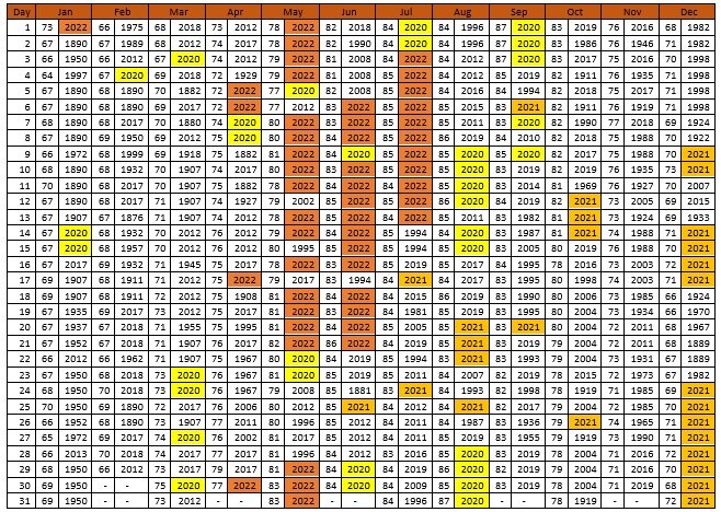
Through July 14th, nearly 30% of Galveston’s record high minimum temperatures have been tied or broken during 2020-2022. For record high maximums, nearly 23% of records have been tied or broken during 2020-2022. Records go back to May 1874.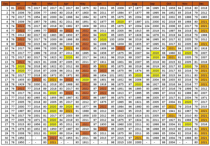
-
Central Park has its first heatwave of the year.
-
There's a lot of variability for La Nina cases. 1998-99 had low snowfall and widespread warmth. 2016-17 had above normal snowfall. We're also poised to have a third consecutive La Nina winter, so there are few, if any, relevant cases. Whether or not blocking develops and is sustained will be critical to snowfall prospects.
-
The seasonal forecast updated on July 1. It updates once per month.
-
Morning thoughts… It will be partly to mostly sunny and hot. High temperatures will reach the upper 80s and lower 90s in most of the region. Likely high temperatures around the region include: New York City (Central Park): 88° Newark: 93° Philadelphia: 92° Tomorrow will be very warm. Normals: New York City: 30-Year: 85.2°; 15-Year: 86.2° Newark: 30-Year: 87.3°; 15-Year: 88.5° Philadelphia: 30-Year: 88.1°; 15-Year: 89.1°
-
Tomorrow will be partly cloudy and continued very warm. However, readings will continue to average near or above normal through at least the coming weekend. Another spell of heat is possible next week. In the South and Southwest, a significant heatwave continues. Phoenix registered a high temperature of 113°. Austin reached 108°, which tied the record set in 2020. Austin has now recorded five consecutive record-tying or record-breaking highs. It also has recorded a record 4 consecutive days with highs of 108° or above. Galveston saw its 11th consecutive day on which the record high minimum temperature was tied or broken. During June 16-20, the MJO has been in Phase 1 at an amplitude of 1.500 or above. Of the six cases that saw such an outcome during June 15-25 (1988, 2003, 2010, 2012, 2017 and 2020), four had a warmer than normal July, one was somewhat cooler than normal and one was cooler than normal. The ECMWF seasonal forecast indicates that the summer will be warmer than normal throughout the region and across much of North America. Based on how the pattern has been evolving during the spring transition to summer, it is more likely than not that the warmest anomalies of the summer will likely occur in July and August with June being the coolest of the three months in the Northeast. The latest ECMWF monthly forecast indicates that July will be warmer than June relative to normal and that August will be the warmest summer month relative to normal. In addition, in the 6 past cases when the June AO averaged +0.750 or above (1950-2021), 50% of the following July cases were warmer than normal. 67% of the following August and September cases featured above normal temperatures. The ENSO Region 1+2 anomaly was -1.2°C and the Region 3.4 anomaly was -0.5°C for the week centered around July 6. For the past six weeks, the ENSO Region 1+2 anomaly has averaged -1.30°C and the ENSO Region 3.4 anomaly has averaged -0.65°C. La Niña conditions will likely persist through the summer. The SOI was +8.68. The preliminary Arctic Oscillation (AO) was +0.363 today. On July 11 the MJO was in Phase 5 at an amplitude of 0.520 (RMM). The July 10-adjusted amplitude was 0.652 (RMM). Based on sensitivity analysis applied to the latest guidance, there is an implied 68% probability that New York City will have a warmer than normal July (1991-2020 normal). July will likely finish with a mean temperature near 78.7° (1.2° above normal).
-
Galveston’s Record Warm Late Spring and Early Summer
donsutherland1 replied to donsutherland1's topic in Climate Change
The extraordinary heat in Galveston (warmest April, May, and June) and elsewhere in Texas (Austin and San Antonio recorded their warmest May and June) reflects a trend in which summers have been growing hotter in Texas. Since 1980, 69% of summers were hotter than the 30-year moving average. Since 2000, that figure has increased to 82%.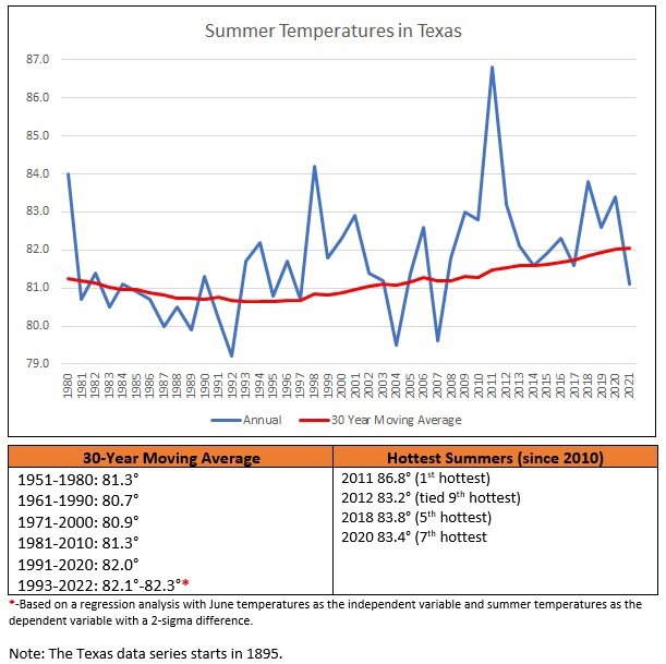
-
Morning thoughts… It will be partly to mostly sunny and hot. High temperatures will reach the upper 80s and lower 90s in most of the region. Likely high temperatures around the region include: New York City (Central Park): 89° Newark: 96° Philadelphia: 91° Tomorrow will be very warm. Normals: New York City: 30-Year: 85.1°; 15-Year: 86.1° Newark: 30-Year: 87.3°; 15-Year: 88.4° Philadelphia: 30-Year: 88.1°; 15-Year: 89.1°
-
Tomorrow will be another hot day. Widespread 90s are possible. Somewhat cooler air will arrive afterward. In the South and Southwest, a significant heatwave continues. Through 4:35 pm MST, Phoenix had a high temperature of 112°. Phoenix will likely see numerous 110° or above temperatures and several minimum temperatures of 90° or above through the remainder of the week. Elsewhere, Austin reached 109° for the third consecutive day. That tied the record for most consecutive days at 109° or above, which was set during August 27-29, 2011. It also toppled the daily record of 107° from 1954. At Galveston, today was the 10th consecutive day on which the daily record high minimum temperature was either tied or broken. During June 16-20, the MJO has been in Phase 1 at an amplitude of 1.500 or above. Of the six cases that saw such an outcome during June 15-25 (1988, 2003, 2010, 2012, 2017 and 2020), four had a warmer than normal July, one was somewhat cooler than normal and one was cooler than normal. The ECMWF seasonal forecast indicates that the summer will be warmer than normal throughout the region and across much of North America. Based on how the pattern has been evolving during the spring transition to summer, it is more likely than not that the warmest anomalies of the summer will likely occur in July and August with June being the coolest of the three months in the Northeast. The latest ECMWF monthly forecast indicates that July will be warmer than June relative to normal and that August will be the warmest summer month relative to normal. In addition, in the 6 past cases when the June AO averaged +0.750 or above (1950-2021), 50% of the following July cases were warmer than normal. 67% of the following August and September cases featured above normal temperatures. The ENSO Region 1+2 anomaly was -1.2°C and the Region 3.4 anomaly was -0.5°C for the week centered around July 6. For the past six weeks, the ENSO Region 1+2 anomaly has averaged -1.30°C and the ENSO Region 3.4 anomaly has averaged -0.65°C. La Niña conditions will likely persist through the summer. The SOI was +12.25. The preliminary Arctic Oscillation (AO) was +0.136 today. On July 10 the MJO was in Phase 5 at an amplitude of 0.658 (RMM). The July 9-adjusted amplitude was 0.897 (RMM). Based on sensitivity analysis applied to the latest guidance, there is an implied 65% probability that New York City will have a warmer than normal July (1991-2020 normal). July will likely finish with a mean temperature near 78.6° (1.1° above normal).
-
Morning thoughts… It will be partly to mostly sunny and hot. Thunderstorms, some f which could be strong, are possible this afternoon or evening. High temperatures will reach the lower and perhaps middle 90s in most of the region. Likely high temperatures around the region include: New York City (Central Park): 89° Newark: 96° Philadelphia: 91° Tomorrow will be hot. Thunderstorms are possible. Normals: New York City: 30-Year: 85.1°; 15-Year: 86.0° Newark: 30-Year: 87.2°; 15-Year: 88.3° Philadelphia: 30-Year: 88.1°; 15-Year: 89.0°
-
Unfortunately, I don't have access to QBO forecasts.
-
A brief surge of heat is likely for tomorrow and Wednesday. Some strong thunderstorms are possible tomorrow afternoon or evening. Widespread 90s are possible. In the South and Southwest, a significant heatwave continues. Through 3:35 pm MST, Phoenix had reached 115° for the first time this year. Phoenix will likely see numerous 110° or above temperatures and several minimum temperatures of 90° or above through the remainder of the week. Parts of Texas saw more record heat. Record high temperatures included: Abilene: 106° (old record: 104°, 1998) Austin: 109° (old record: 108°, 1917) San Antonio: 107° (old record: 104°, 1917) During June 16-20, the MJO has been in Phase 1 at an amplitude of 1.500 or above. Of the six cases that saw such an outcome during June 15-25 (1988, 2003, 2010, 2012, 2017 and 2020), four had a warmer than normal July, one was somewhat cooler than normal and one was cooler than normal. The ECMWF seasonal forecast indicates that the summer will be warmer than normal throughout the region and across much of North America. Based on how the pattern has been evolving during the spring transition to summer, it is more likely than not that the warmest anomalies of the summer will likely occur in July and August with June being the coolest of the three months in the Northeast. The latest ECMWF monthly forecast indicates that July will be warmer than June relative to normal and that August will be the warmest summer month relative to normal. In addition, in the 6 past cases when the June AO averaged +0.750 or above (1950-2021), 50% of the following July cases were warmer than normal. 67% of the following August and September cases featured above normal temperatures. The ENSO Region 1+2 anomaly was -1.2°C and the Region 3.4 anomaly was -0.5°C for the week centered around July 6. For the past six weeks, the ENSO Region 1+2 anomaly has averaged -1.30°C and the ENSO Region 3.4 anomaly has averaged -0.65°C. La Niña conditions will likely persist through the summer. The SOI was +8.99. The preliminary Arctic Oscillation (AO) was +0.002 today. On July 9 the MJO was in Phase 5 at an amplitude of 0.905 (RMM). The July 8-adjusted amplitude was 1.120 (RMM). Based on sensitivity analysis applied to the latest guidance, there is an implied 62% probability that New York City will have a warmer than normal July (1991-2020 normal). July will likely finish with a mean temperature near 78.5° (1.0° above normal).
-
Morning thoughts… It will be partly to mostly sunny and warm. High temperatures will reach the middle and upper 80s in most of the region. Likely high temperatures around the region include: New York City (Central Park): 84° Newark: 90° Philadelphia: 87° Tomorrow and Wednesday will be hot. Thunderstorms are possible. Normals: New York City: 30-Year: 85.0°; 15-Year: 85.9° Newark: 30-Year: 87.2°; 15-Year: 88.2° Philadelphia: 30-Year: 88.1°; 15-Year: 89.0°
-
Tomorrow will be mostly sunny and warm. A brief surge of heat is possible for Tuesday and Wednesday. At that time, widespread 90s are possible. In the South and Southwest, a significant heatwave continues. Through 4:51 pm MST, Phoenix had a high temperature of 113°. Phoenix will likely see numerous 110° or above temperatures and several minimum temperatures of 90° or above through the middle of next week. Afterward, somewhat cooler air will close out the week. Records included: Abilene, TX: 106° (tied record set in 1918) Austin: 110° (old record: 105°, 1917) Brownsville: 100° (old record: 99°, 1917) College Station, TX: 111° (old record: 109°, 1917) Corpus Christi: 100° (old record: 98°, 1953, 1964, 1975 and 2009) Houston: 104° (old record: 101°, 1909, 1980 and 1998) Galveston: 96° (tied record set in 1931) McCook, NE: 111° (old record: 109°, 1954) Pueblo, CO: 107° (old record: 105°, 2016) San Antonio: 106° (old record: 105°, 1930) Galveston also registered its record-tying 7th consecutive low temperature of 85°. During June 16-20, the MJO has been in Phase 1 at an amplitude of 1.500 or above. Of the six cases that saw such an outcome during June 15-25 (1988, 2003, 2010, 2012, 2017 and 2020), four had a warmer than normal July, one was somewhat cooler than normal and one was cooler than normal. The ECMWF seasonal forecast indicates that the summer will be warmer than normal throughout the region and across much of North America. Based on how the pattern has been evolving during the spring transition to summer, it is more likely than not that the warmest anomalies of the summer will likely occur in July and August with June being the coolest of the three months in the Northeast. The latest ECMWF monthly forecast indicates that July will be warmer than June relative to normal and that August will be the warmest summer month relative to normal. In addition, in the 6 past cases when the June AO averaged +0.750 or above (1950-2021), 50% of the following July cases were warmer than normal. 67% of the following August and September cases featured above normal temperatures. The ENSO Region 1+2 anomaly was -1.4°C and the Region 3.4 anomaly was -0.6°C for the week centered around June 29. For the past six weeks, the ENSO Region 1+2 anomaly has averaged -1.28°C and the ENSO Region 3.4 anomaly has averaged -0.73°C. La Niña conditions will likely persist through the summer. The SOI was +9.23. The preliminary Arctic Oscillation (AO) was +0.197 today. On July 8 the MJO was in Phase 5 at an amplitude of 1.120 (RMM). The July 7-adjusted amplitude was 1.331 (RMM). Based on sensitivity analysis applied to the latest guidance, there is an implied 61% probability that New York City will have a warmer than normal July (1991-2020 normal). July will likely finish with a mean temperature near 78.5° (1.0° above normal).
-
Morning thoughts… It will be partly to mostly sunny and warm. High temperatures will reach the lower and middle 80s in most of the region. Likely high temperatures around the region include: New York City (Central Park): 82° Newark: 88° Philadelphia: 86° Tomorrow will be mostly sunny and pleasant but hot weather will likely return for Tuesday and Wednesday. Normals: New York City: 30-Year: 85.0°; 15-Year: 85.8° Newark: 30-Year: 87.1°; 15-Year: 88.1° Philadelphia: 30-Year: 88.0°; 15-Year: 88.9°
-
Tomorrow and Monday will be mostly sunny and warm. A brief surge of heat is possible for Tuesday and Wednesday. At that time, widespread 90s are possible. In the Southwest, a significant heatwave continues. Through 3:30 pm MST, Phoenix has had a high temperature of 112°. Phoenix will likely see numerous 110° or above temperatures and several minimum temperatures of 90° or above through the middle of next week. Afterward, somewhat cooler air will close out the week. Elsewhere, Denver reached 100° (old record: 98°, 1903, 1989 and 2021) and Salt Lake City reached 102° (tied record set in 1939 and tied in 1994). During June 16-20, the MJO has been in Phase 1 at an amplitude of 1.500 or above. Of the six cases that saw such an outcome during June 15-25 (1988, 2003, 2010, 2012, 2017 and 2020), four had a warmer than normal July, one was somewhat cooler than normal and one was cooler than normal. The ECMWF seasonal forecast indicates that the summer will be warmer than normal throughout the region and across much of North America. Based on how the pattern has been evolving during the spring transition to summer, it is more likely than not that the warmest anomalies of the summer will likely occur in July and August with June being the coolest of the three months in the Northeast. The latest ECMWF monthly forecast indicates that July will be warmer than June relative to normal and that August will be the warmest summer month relative to normal. In addition, in the 6 past cases when the June AO averaged +0.750 or above (1950-2021), 50% of the following July cases were warmer than normal. 67% of the following August and September cases featured above normal temperatures. The ENSO Region 1+2 anomaly was -1.4°C and the Region 3.4 anomaly was -0.6°C for the week centered around June 29. For the past six weeks, the ENSO Region 1+2 anomaly has averaged -1.28°C and the ENSO Region 3.4 anomaly has averaged -0.73°C. La Niña conditions will likely persist through the summer. The SOI was +4.62. The preliminary Arctic Oscillation (AO) was +0.520 today. On July 7 the MJO was in Phase 5 at an amplitude of 1.329 (RMM). The July 6-adjusted amplitude was 1.433 (RMM). Based on sensitivity analysis applied to the latest guidance, there is an implied 61% probability that New York City will have a warmer than normal July (1991-2020 normal). July will likely finish with a mean temperature near 78.4° (0.9° above normal).
-
Thanks for sharing that memory.
-
Galveston’s Record Warm Late Spring and Early Summer
donsutherland1 replied to donsutherland1's topic in Climate Change
In The Trappers of Arkansas published in 1876, Gustave Aimard wrote of Galveston: Galveston is built on the small muddy islet of Sgt. Louis, which closes up the mouth of the Rio Trinidad. At that time the houses were low, built of wood, and surrounded by gardens planted with fragrant trees, which impregnated the atmosphere with delicious odors. Unfortunately there is one thing that cannot alter—the climate… The suffocating heat that is summer prevails in the town corrodes the earth and changes it into an impalpable dust, in which you sink up to the knees, and which at the least breath of air, penetrates into the eyes, mouth, and nostrils… [T]hese grievous occurrences… render a residence at Galveston insupportable at times. Today, summer’s fiery heat has grown even more intense. Like many areas, Galveston has been witnessing increasing summer heat on account of an expanding urban heat island and anthropogenic climate change. Summer heat that was once seemingly unthinkable is rapidly becoming the norm. 1875 was Galveston’s benchmark summer. Then, the small town of about 20,000 residents sweltered under unrelenting heat for much of the summer. Summer 1875 concluded with a mean temperature of 85.4°. The years passed and the record remained unmatched. Decades passed and still the record stood. A century passed and 1875 stood alone at the top of the thermometer. It seemed that the record was destined to stand for all-time, even as the city grew rapidly to 250,000 people by 2000. But then in 2005, the longstanding record was finally toppled. The much larger city experienced a summer average of 85.8°. Two years later, that mark would be vaporized by a figure of 87.3°. Prior to 2005, 1875 was the only summer that had ever seen the mercury average 85° or above. Before 2010, just 3 of Galveston’s 135 (2.2%) summers had a mean temperature of 85° or above. But then, things changed dramatically. From 2010 through 2021, 8 of the 12 summers—or two-thirds of summers—saw the temperature average 85° or above. That 12-year period saw summers average 85.3°, barely below the 1875 figure that had stood for 130 years. Summer 2022 is very likely to become yet another summer with a mean temperature of 85° or above following its historically warm June (87.5° mean temperature).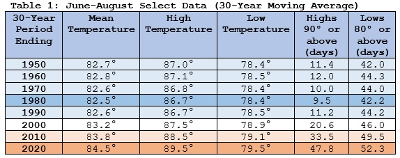
-
Occasional Thoughts on Climate Change
donsutherland1 replied to donsutherland1's topic in Climate Change
On July 8, the U.S. Bureau of Ocean Energy Management announced up to 11 potential lease sales for expanded oil and gas drilling (10 in the Gulf of Mexico and 1 in the northern portion of Alaska’s Cook Inlet). With greenhouse gas emissions continuing to accumulate, expansion of oil and gas production would be shortsighted and destructive. A short-term increase in prices does not justify the much greater long-term costs associated with such production. I submitted the following comment in opposition of the proposal: I respectfully submit the following comments on the Proposed Program for the 2023-2028 National Outer Continental Shelf Oil and Gas Leasing Program (National OCS Program). The Proposed Program includes no more than ten potential lease sales in the Gulf of Mexico (GOM) and an option for one potential lease sale in the northern portion of the Cook Inlet of Alaska. Due to the ongoing grave and growing climate crisis, no lease sales should be permitted anywhere on United States lands or waters. The science is clear. There is no ambiguity. The world’s climate is changing. Human activities, particularly the burning of fossil fuels, are the predominant driver of ongoing warming and a range of related adverse consequences. Less than one year ago, in August 2021, the Intergovernmental Panel on Climate Change (IPCC) summarized the science as it stands today. In its Sixth Assessment Report, the IPCC explained: It is unequivocal that human influence has warmed the atmosphere, ocean and land. Widespread and rapid changes in the atmosphere, ocean, cryosphere and biosphere have occurred... Each of the last four decades has been successively warmer than any decade that preceded it since 1850. Global surface temperature in the first two decades of the 21st century (2001–2020) was 0.99 [0.84 to 1.10] °C higher than 1850–1900… Human influence has warmed the climate at a rate that is unprecedented in at least the last 2000 years.1 Climate change is leading to a growing incidence of extreme outcomes. The IPCC continued: It is virtually certain that hot extremes (including heatwaves) have become more frequent and more intense across most land regions since the 1950s, while cold extremes (including cold waves) have become less frequent and less severe, with high confidence that human-induced climate change is the main driver of these changes. Some recent hot extremes observed over the past decade would have been extremely unlikely to occur without human influence on the climate system. Marine heatwaves have approximately doubled in frequency since the 1980s (high confidence), and human influence has very likely contributed to most of them since at least 2006... The frequency and intensity of heavy precipitation events have increased since the 1950s over most land area for which observational data are sufficient for trend analysis (high confidence), and human-induced climate change is likely the main driver... Human influence has likely increased the chance of compound extreme events since the 1950s. This includes increases in the frequency of concurrent heatwaves and droughts on the global scale (high confidence)...2 The United States has experienced extreme weather in recent years. Four examples include: Summer 2019: Anchorage saw its warmest June, warmest July, and warmest August on record. On July 4, Anchorage recorded its first ever 90° temperature. On 8 days, the temperature reached 80° or above (old record: 4 days, 2015). The average summer temperature was 62.8°. The prior record of 60.8° was set in 2016. Summer 2020: Phoenix recorded its hottest summer on record. July (mean temperature: 98.9°) was Phoenix’s hottest month on record by 0.6°. August surpassed that mark with a 99.1° mean temperature. Select summer heat records included: high temperatures of 110° or above: 48 days (old record: 31 days, 2007 and 2011); high temperatures of 115° or above: 13 days (old record: 7 days, 1974); low temperatures of 90° or above: 28 days (old record: 15 days, 2003 and 2013). For the year, Phoenix set records for most 100° high temperatures (145 days); 110° high temperatures (53 days); 115° high temperatures (14 days); and, 90° low temperatures (28 days). The summer mean temperature of 96.7° easily surpassed the earlier record of 95.1°, which was set in 2013 and tied in 2015. Summer 2021: A historic heatwave demolished longstanding records in the Pacific Northwest. June 26-28 saw the highest temperatures in the region. At Portland, high temperatures were 108°, 112°, and 116° respectively. At Seattle, high temperatures were 102°, 104°, and 108° respectively. An attribution study following the extreme heatwave concluded that the magnitude of the heat “was virtually impossible without human-caused climate change.”3 Late Spring-Early Summer 2022: As of this writing, Galveston has seen its warmest April, warmest May, and warmest June on record. May had a mean temperature of 83.0° (old record: 80.4°, 2018). June had a mean temperature of 87.5° (old record: 86.2°, 2011). Only August 2011, 2019, and 2020 were warmer. During the 61 days in May-June, 29 record high maximum temperatures were tied or broken and 33 record high minimum temperatures were tied or broken. The 86° low temperature on June 21st was the earliest such temperature on record (old record: August 8, 2019). Climate change is producing aridification in the Southwestern United States. Aridification is the process that leads to a hotter and drier climate. As part of that process, the region is experiencing a historic drought that began in 1999.4 Aridification leads to “progressively lower river flows, drier landscapes, higher forest mortality, and more severe and widespread wildfires.”5 Recently, Nevada’s Lake Mead has reached its lowest levels on record.6 Utah’s Great Salt Lake has reached record lows twice this year.7 As aridification advances, the need for tough trade-offs from water rationing will likely become increasingly frequent. Longer-term, a chronic water shortage will lead to the need to rethink agricultural and other economic activity in this region. Such a shortage could drive a population movement out of the Southwest. Climate change is also deadly. In the United States, heat now causes more deaths than any other form of weather.8 Research has estimated that projected yearly excess deaths from climate change would be relatively stable at approximately 100,000 per year when warming is held below 2°C.9 However, the projected yearly excess deaths increase at an accelerating rate as warming increases to about 4.6 million at 4.1°C.10 Despite all the net adverse consequences of climate change—for the United States and globally—and the clear responsibility of fossil fuel burning for anthropogenic climate change, advocates of expanded oil and gas exploitation will very likely justify their case with two major arguments. They will assert that expanded exploitation is necessary to ensure a stable energy market with sufficient flexibility to accommodate a growing population and economy. They will suggest that the dramatic recent increase in oil and gas prices on account of Russia’s invasion of Ukraine make the rapid introduction of new supplies necessary. Both lines of argument fit the classic dictionary definition of shortsighted11 prescriptions. The first line of argument conflates oil and gas with energy supply. An aggressive scaling up of renewable energy sources could readily meet the medium- and longer-term supply needs of a growing economy and population without the climate-destructive greenhouse gas pollution. There is no compelling reason that fossil fuels should be indistinguishable from energy supply. The second line of argument also fails. First, assuming the leased areas have discovered oil and gas reserves, it would take 6-12 months for production to commence.12 The second and more devastating counterargument is that policy would essentially be making a structural long-term commitment to expanded fossil fuel production and greenhouse gas pollution to try to address a short-term, temporary dislocation in the oil and gas market. There is virtually no probability that once the investments have been made and oil and gas production expanded, such production would immediately cease once prices come down and stabilize at lower levels. The profit motive would assure the opposite outcome. In short, policymakers would commit to a near-permanent increase in global temperatures (and related consequences) all to try to resolve a short-term, temporary issue. The mismatch between short-term challenges and long-term consequences could not be starker. The second line of argument also falls for ethical reasons. Aging policymakers, who have limited life exposure to the consequences of their choice, would be imposing more severe climate change on younger people and future generations whose lifetime exposure is much greater. This would be an incredibly selfish decision from which younger people and future generations would have no recourse. It is also a somewhat cowardly decision, as the responsible policymakers will have left the scene long before future generations suffer through the most devastating consequences of the departed leaders’ terrible choice. The decision to expand fossil fuel production despite full knowledge of climate change, its causes, and its consequences, would be nothing less than a catastrophic failure of leadership. It would be a product of shortsightedness, absence of ethical regard for the lives and wellbeing of younger people and future generations who would suffer irreparable harm, and a lack of confidence in American innovation to liberate the nation from an unsustainable and destructive energy status quo. Today, in response to oil and gas prices having risen to their highest level in just over a decade13 in response to temporary factors (the sharp post-COVID economic rebound and disruptions related to the Russian invasion of Ukraine), there has been an all-out scramble to secure new oil and gas supplies. This proposed lease is one element of that rush. That there was no comparable urgency to scale up renewable energy investments and infrastructure and slash the burning of fossil fuels following publication of the IPCC’s Sixth Assessment Report says much about current United States and international priorities. Despite the gravity and urgency of climate change, there remains a deep-seated inability or unwillingness to break from the a harmful fossil fuel-centered status quo. Those priorities are badly misplaced. In the end, if the proposed leases are approved, future generations will forever be astonished how the leaders of one of the most advanced, prosperous, and powerful nations in human history, embraced enhanced climate change. They will be haunted by questions about how any rational and ethical leaders—particularly those who possessed knowledge of the gravity and urgency of climate change and who understood its causes—still chose to impose a hotter and more unstable climate on future generations. What kind of leaders and what kind of country would purposely doom posterity to tragic centuries of lost dreams and ever-present climate catastrophes all to mitigate a modest and temporary challenge arising from energy sources that need to be phased out? Is this the legacy this Administration seeks? Is this the tomorrow it desires? Most importantly, is this the future it will choose? The United States can still avoid choosing more global warming, more extreme weather, and more climate-related fatalities. This proposed leasing program should be withdrawn. No additional oil and gas leases should be offered in the future. Instead, the United States should increase its efforts to decarbonize and accelerate its transition to renewable energy. It should pursue a better future for its youth and forthcoming generations while it still enjoys the luxury of choosing such a future. Endnotes: 1. IPCC, 2021: Summary for Policymakers. In: Climate Change 2021: The Physical Science Basis. Contribution of Working Group I to the Sixth Assessment Report of the Intergovernmental Panel on Climate Change [Masson-Delmotte, V., P. Zhai, A. Pirani, S.L. Connors, C. Péan, S. Berger, N. Caud, Y. Chen, L. Goldfarb, M.I. Gomis, M. Huang, K. Leitzell, E. Lonnoy, J.B.R. Matthews, T.K. Maycock, T. Waterfield, O. Yelekçi, R. Yu, and B. Zhou (eds.)]. Cambridge University Press, Cambridge, United Kingdom and New York, NY, USA, pp.4-6. 2. Ibid., pp.8-9. 3. https://www.worldweatherattribution.org/western-north-american-extreme-heat-virtually-impossible-without-human-caused-climate-change/ 4. Jonathan T. Overpeck and Bradley Udall, “Climate change and the aridification of North America,” PNAS, May 19, 2020, p.11856. 5. Ibid., p.11857. 6. https://www.nbcnews.com/science/environment/lake-mead-nearing-dead-pool-status-engineer-was-named-horrified-rcna35030 7. Claire Hardwick, “Water levels at Utah’s Great Salt Lake drop to record low for second time in a year,” USA Today, July 7, 2022. 8. https://www.weather.gov/hazstat/ 9. Bressler, R.D. The mortality cost of carbon. Nat Commun 12, 4467 (2021), p.6 10. Ibid., pp.4-5. 11. Shortsighted: lacking foresight (https://www.merriam-webster.com/dictionary/shortsighted) 12. https://www.cnbc.com/2022/04/15/biden-administration-to-resume-leasing-for-oil-and-gas-drilling-on-federal-lands.html 13. https://www.eia.gov/finance/markets/crudeoil/spot_prices.php and https://www.eia.gov/dnav/ng/hist/rngwhhdm.htm -
Morning thoughts… Overnight, Washington, DC picked up 4.00” of rain. Two consecutive hours saw 1.51” and 1.53” fall. Prior to then, only June 25, 2006 had two consecutive hours with 1” or more rainfall. It will be partly to mostly sunny and warm except from southern New Jersey southward where it will be mostly cloudy with some showers. High temperatures will reach the lower and middle 80s in most of the region. Likely high temperatures around the region include: New York City (Central Park): 83° Newark: 89° Philadelphia: 82° Tomorrow will be mostly sunny and pleasant. Normals: New York City: 30-Year: 84.9°; 15-Year: 85.6° Newark: 30-Year: 87.1°; 15-Year: 88.0° Philadelphia: 30-Year: 88.0°; 15-Year: 88.8°
-
Washington, DC has now picked up 1” or more of rain in two consecutive hours. The last time that occurred was June 25, 2006.
-
Tomorrow will be mainly cloudy and cool. Scattered showers and thundershowers are possible. However, much of the time, there will be no precipitation. In the Southwest, a significant heatwave has now descended on the region. As of 3:35 pm MST, Phoenix had a high temperature of 110°. Phoenix will likely see numerous 110° or above temperatures and several minimum temperatures of 90° or above through the middle of next week. The heat also stretched into the Gulf States and Southeast. Memphis saw a high temperature of 103°, which surpassed the daily record of 101° set in 1969 and tied in 1980. Next week could see a brief surge of heat into the region. Widespread 90s are possible on one or two days. Overall, the month will likely wind up somewhat warmer than normal. During June 16-20, the MJO has been in Phase 1 at an amplitude of 1.500 or above. Of the six cases that saw such an outcome during June 15-25 (1988, 2003, 2010, 2012, 2017 and 2020), four had a warmer than normal July, one was somewhat cooler than normal and one was cooler than normal. The ECMWF seasonal forecast indicates that the summer will be warmer than normal throughout the region and across much of North America. Based on how the pattern has been evolving during the spring transition to summer, it is more likely than not that the warmest anomalies of the summer will likely occur in July and August with June being the coolest of the three months in the Northeast. The latest ECMWF monthly forecast indicates that July will be warmer than June relative to normal and that August will be the warmest summer month relative to normal. In addition, in the 6 past cases when the June AO averaged +0.750 or above (1950-2021), 50% of the following July cases were warmer than normal. 67% of the following August and September cases featured above normal temperatures. The ENSO Region 1+2 anomaly was -1.4°C and the Region 3.4 anomaly was -0.6°C for the week centered around June 29. For the past six weeks, the ENSO Region 1+2 anomaly has averaged -1.28°C and the ENSO Region 3.4 anomaly has averaged -0.73°C. La Niña conditions will likely persist through the summer. The SOI was -3.02. The preliminary Arctic Oscillation (AO) was +0.704 today. On July 6 the MJO was in Phase 4 at an amplitude of 1.431 (RMM). The July 5-adjusted amplitude was 1.593 (RMM). Based on sensitivity analysis applied to the latest guidance, there is an implied 56% probability that New York City will have a warmer than normal July (1991-2020 normal). July will likely finish with a mean temperature near 78.2° (0.7° above normal).
-
Morning thoughts… It will be partly to mostly cloudy and warm. High temperatures will reach the middle and upper 80s in most of the region. Likely high temperatures around the region include: New York City (Central Park): 83° Newark: 89° Philadelphia: 87° Tomorrow will be mainly cloudy and cool. Normals: New York City: 30-Year: 84.8°; 15-Year: 85.5° Newark: 30-Year: 87.0°; 15-Year: 87.8° Philadelphia: 30-Year: 87.9°; 15-Year: 88.7°
-
Unsettled weather could persist through Saturday. Scattered showers and thundershowers will be possible, along with cooler temperatures. However, much of the time, there will be no precipitation. In the Southwest, a significant heatwave is poised to develop. From tomorrow into the middle of next week, Phoenix will likely see numerous 110° or above temperatures and several minimum temperatures of 90° or above. The first 10 days of July could see near normal readings overall in the Northeast. A brief surge of heat could follow afterward. Overall, the month will likely wind up somewhat warmer than normal. The newest EPS weeklies suggest that a sustained period of above normal temperatures could develop after mid-July. During June 16-20, the MJO has been in Phase 1 at an amplitude of 1.500 or above. Of the six cases that saw such an outcome during June 15-25 (1988, 2003, 2010, 2012, 2017 and 2020), four had a warmer than normal July, one was somewhat cooler than normal and one was cooler than normal. The ECMWF seasonal forecast indicates that the summer will be warmer than normal throughout the region and across much of North America. Based on how the pattern has been evolving during the spring transition to summer, it is more likely than not that the warmest anomalies of the summer will likely occur in July and August with June being the coolest of the three months in the Northeast. The latest ECMWF monthly forecast indicates that July will be warmer than June relative to normal and that August will be the warmest summer month relative to normal. In addition, in the 6 past cases when the June AO averaged +0.750 or above (1950-2021), 50% of the following July cases were warmer than normal. 67% of the following August and September cases featured above normal temperatures. The ENSO Region 1+2 anomaly was -1.4°C and the Region 3.4 anomaly was -0.6°C for the week centered around June 29. For the past six weeks, the ENSO Region 1+2 anomaly has averaged -1.28°C and the ENSO Region 3.4 anomaly has averaged -0.73°C. La Niña conditions will likely persist through the summer. The SOI was +4.99. The preliminary Arctic Oscillation (AO) was +1.013 today. On July 5 the MJO was in Phase 4 at an amplitude of 1.589 (RMM). The July 4-adjusted amplitude was 1.647 (RMM). Based on sensitivity analysis applied to the latest guidance, there is an implied 56% probability that New York City will have a warmer than normal July (1991-2020 normal). July will likely finish with a mean temperature near 78.2° (0.7° above normal).
-
Morning thoughts… It will be partly to mostly cloudy and cooler. A few locations could see a shower or thundershower. High temperatures will reach the lower and middle 80s in most of the region. Likely high temperatures around the region include: New York City (Central Park): 82° Newark: 85° Philadelphia: 82° Unsettled weather will continue through Saturday. Normals: New York City: 30-Year: 84.7°; 15-Year: 85.3° Newark: 30-Year: 86.9°; 15-Year: 87.7° Philadelphia: 30-Year: 87.8°; 15-Year: 88.6°

