

donsutherland1
-
Posts
24,156 -
Joined
Content Type
Profiles
Blogs
Forums
American Weather
Media Demo
Store
Gallery
Everything posted by donsutherland1
-
Morning thoughts… Today will be mostly sunny and cool. High temperatures will reach the lower and middle 70s in most of the region. Likely high temperatures around the region include: New York City (Central Park): 70° Newark: 73° Philadelphia: 74° Tomorrow and Monday will see a continuation of the cool weather. Normals: New York City: 30-Year: 80.6°; 15-Year: 80.4° Newark: 30-Year: 82.8°; 15-Year: 82.8° Philadelphia: 30-Year: 84.1°; 15-Year: 84.3°
-
A piece of the air mass responsible for record-breaking heat in the Plains States and Great Lakes Region moved across the Middle Atlantic region today. Near record and record high temperatures in the Southeast and Middle Atlantic Region included: Atlantic City: 93° Baltimore: 96° (tied record set in 1939) Bridgeport: 90° Charlotte: 98° Columbia, SC: 100° Islip: 90° (old record: 88°, 2000) Lynchburg: 96° (tied record set in 1944) New York City-JFK: 94° New York City-LGA: 92° Newark: 95° Norfolk: 97° (tied record set in 1891 and tied in 1945) Philadelphia: 96° Raleigh: 98° Richmond: 97° Sterling, VA: 96° (old record: 92°, 1994) Washington, DC: 99° (old record: 97°, 2014) Wilmington, DE: 95° Wilmington, NC: 96° Following today's brief burst of heat, much cooler air will return for the weekend. The unseasonably cool weather will continue until midweek next week before warmer air returns. Across the Atlantic Ocean, a record early-season heatwave scorched parts of western Europe. High temperatures included: Andujar, Spain: 112° Carcassonne, France: 105° Cognac, France: 102° London: 91° Nimes, France: 105° Paris: 95° The ECMWF seasonal forecast indicates that the summer will be warmer than normal throughout the region and across much of North America. Based on how the pattern has been evolving during the spring transition to summer, it is more likely than not that the warmest anomalies of the summer will likely occur in July and August with June being the coolest of the three months in the Northeast. The latest ECMWF monthly forecast indicates that July will be warmer than June relative to normal and that August will be the warmest summer month relative to normal. The ENSO Region 1+2 anomaly was -1.6°C and the Region 3.4 anomaly was -0.7°C for the week centered around June 8. For the past six weeks, the ENSO Region 1+2 anomaly has averaged -1.28°C and the ENSO Region 3.4 anomaly has averaged -1.00°C. La Niña conditions will likely persist through the summer. The SOI was +23.55 today. The preliminary Arctic Oscillation (AO) was +0.342 today. On June 15 the MJO was in Phase 1 at an amplitude of 1.893 (RMM). The June 14-adjusted amplitude was 1.594 (RMM). Based on sensitivity analysis applied to the latest guidance, there is an implied 52% probability that New York City will have a warmer than normal June (1991-2020 normal). June will likely finish with a mean temperature near 72.2° (0.2° above normal).
-
99 so far.
-
Morning thoughts… Today will be mostly sunny and very warm. High temperatures will reach the upper 80s and lower 90s in most of the region. Likely high temperatures around the region include: New York City (Central Park): 89° Newark: 94° Philadelphia: 95° Much cooler air will arrive for the weekend. Normals: New York City: 30-Year: 80.3°; 15-Year: 80.1° Newark: 30-Year: 82.5°; 15-Year: 82.5° Philadelphia: 30-Year: 83.8°; 15-Year: 84.0°
-
Tomorrow will be a very warm day with readings reaching the upper 80s in New York City and perhaps lower 90s in Newark and Philadelphia. Much cooler air will return for the weekend. The ECMWF seasonal forecast indicates that the summer will be warmer than normal throughout the region and across much of North America. Based on how the pattern has been evolving during the spring transition to summer, it is more likely than not that the warmest anomalies of the summer will likely occur in July and August with June being the coolest of the three months in the Northeast. The latest ECMWF monthly forecast indicates that July will be warmer than June relative to normal and that August will be the warmest summer month relative to normal. The ENSO Region 1+2 anomaly was -1.6°C and the Region 3.4 anomaly was -0.7°C for the week centered around June 8. For the past six weeks, the ENSO Region 1+2 anomaly has averaged -1.28°C and the ENSO Region 3.4 anomaly has averaged -1.00°C. La Niña conditions will likely persist through the summer. The SOI was +16.52 today. The SOI was unchanged from yesterday. The last time that happened was December 24-25, 2020. The preliminary Arctic Oscillation (AO) was -0.056 today. On June 14 the MJO was in Phase 1 at an amplitude of 1.587 (RMM). The June 13-adjusted amplitude was 1.338 (RMM). Based on sensitivity analysis applied to the latest guidance, there is an implied 52% probability that New York City will have a warmer than normal June (1991-2020 normal). June will likely finish with a mean temperature near 72.2° (0.2° above normal).
-
Morning thoughts… At 6:10, a line of showers and thunderstorms stretched from just west of Wilmington, DE to just south of Albany. After some early showers and thundershowers, it will be variably cloudy and cooler. Additional showers and thunderstorms are likely as a warm front moves slowly across the region. High temperatures will reach the middle and upper 70s in most of the region. Likely high temperatures around the region include: New York City (Central Park): 73° Newark: 77° Philadelphia: 81° Tomorrow will be very warm, but much cooler air will arrive for the weekend. Normals: New York City: 30-Year: 80.0°; 15-Year: 79.8° Newark: 30-Year: 82.1°; 15-Year: 82.2° Philadelphia: 30-Year: 83.5°; 15-Year: 83.7°
-
Galveston’s Record Warm Late Spring and Early Summer
donsutherland1 replied to donsutherland1's topic in Climate Change
At Galveston, which has seen two consecutive warm monthly records, June 1-15 was, by far, the warmest first half of June on record. The mean temperature was 87.1°. The old record was 85.3°, which was set in 2018. Galveston has already seen 9 days with low temperatures of 83° or above. The previous record for the entire month was 7 days. That record was set in 1994. Records go back to June 1874. -
The passage of a warm front could bring some showers or thundershowers tomorrow. Friday will be a very warm day with readings reaching the upper 80s in New York City and perhaps lower 90s in Newark and Philadelphia. Much cooler air will return for the weekend. Intense heat scorched the Great Lakes Region and Southeast today. Record high temperatures included: Athens, GA: 99° (tied record set in 1918) Atlanta: 99° (old record: 96°, 143 and 1952) Chicago: 96° (old record: 95°, 1952, 1954 and 1994) Flint, MI: 93° (tied record set in 1954 and tied in 1988) Lansing, MI: 95° (92°, 1894, 1954, 1967, 1988, and 1994) Macon, GA: 104° (old record: 100°, 2010 and 2011) Rockford, IL: 97° (old record: 95°, 1994) Toledo: 98° (old record: 96°, 1994) Youngstown, OH: 93° (tied record set in 1994) At Galveston, which has seen two consecutive warm monthly records, June 1-15 was, by far, the warmest first half of June on record. The mean temperature was 87.1°. The old record was 85.3°, which was set in 2018. Galveston has already seen 9 days with low temperatures of 83° or above. The previous record for the entire month was 7 days. That record was set in 1994. Records go back to June 1874. In the desert Southwest, today marked the beginning of monsoon season. Phoenix could receive measurable rainfall on Saturday and perhaps Sunday as the first monsoonal moisture flows northward. The wettest monsoon season brought 9.56" of rain to Phoenix during 1984. The driest season was 1924 when just 0.35" of rain was measured. Phoenix receives an average of 2.42" of rain during the monsoon season (1991-2020). In 1961-90, the average was 2.78". Ongoing aridification is reducing precipitation to the Southwest. The ECMWF seasonal forecast indicates that the summer will be warmer than normal throughout the region and across much of North America. Based on how the pattern has been evolving during the spring transition to summer, it is more likely than not that the warmest anomalies of the summer will likely occur in July and August with June being the coolest of the three months in the Northeast. The latest ECMWF monthly forecast indicates that July will be warmer than June relative to normal and that August will be the warmest summer month relative to normal. The ENSO Region 1+2 anomaly was -1.6°C and the Region 3.4 anomaly was -0.7°C for the week centered around June 8. For the past six weeks, the ENSO Region 1+2 anomaly has averaged -1.28°C and the ENSO Region 3.4 anomaly has averaged -1.00°C. La Niña conditions will likely persist through the summer. The SOI was +16.52 today. The preliminary Arctic Oscillation (AO) was +0.413 today. On June 13 the MJO was in Phase 1 at an amplitude of 1.340 (RMM). The June 12-adjusted amplitude was 1.251 (RMM). Based on sensitivity analysis applied to the latest guidance, there is an implied 54% probability that New York City will have a warmer than normal June (1991-2020 normal). June will likely finish with a mean temperature near 72.3° (0.4° above normal).
-
Morning thoughts… It will be partly cloudy and warm. High temperatures will reach the lower and middle 80s in most of the region. Likely high temperatures around the region include: New York City (Central Park): 81° Newark: 86° Philadelphia: 88° Much cooler air will arrive for the weekend.
-
Hottest Weather So Far Lies Ahead for Phoenix
donsutherland1 replied to donsutherland1's topic in Central/Western States
Tomorrow will mark the start of monsoon season in the Southwest. Phoenix could see some early monsoonal rains this weekend. Below are Phoenix’s monsoon season highlights: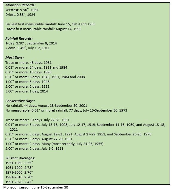
-
Tomorrow will be another partly sunny and warm day. The passage of a warm front could bring some showers or thundershowers on Thursday. Overall, the remainder of the week will generally see somewhat above normal to above normal temperatures. Intense heat moved into the Great Lakes Region today. High temperatures included: Atlanta: 95° Charleston, SC: 98° Chicago: 98° Fayetteville, NC: 100° (tied record set in 1940) Indianapolis: 93° Lexington, KY: 95° (old record: 94°, 1943 and 1988) Rockford, IL: 98° (tied record set in 1987) Savannah: 98° St. Louis: 99° (old record: 97°, 1987) Tomorrow will be another very hot day in parts of the Great Lakes Region before cooler air returns. The core of the heat will not likely move into the Northeast. As a result, New York City will likely see temperatures peak in the middle and upper 80s on Friday. Newark could reach 90°. The ECMWF seasonal forecast indicates that the summer will be warmer than normal throughout the region and across much of North America. Based on how the pattern has been evolving during the spring transition to summer, it is more likely than not that the warmest anomalies of the summer will likely occur in July and August with June being the coolest of the three months in the Northeast. The latest ECMWF monthly forecast indicates that July will be warmer than June relative to normal and that August will be the warmest summer month relative to normal. The ENSO Region 1+2 anomaly was -1.6°C and the Region 3.4 anomaly was -0.7°C for the week centered around June 8. For the past six weeks, the ENSO Region 1+2 anomaly has averaged -1.28°C and the ENSO Region 3.4 anomaly has averaged -1.00°C. La Niña conditions will likely persist through the summer. The SOI was +20.03 today. The preliminary Arctic Oscillation (AO) was +1.360 today. On June 12 the MJO was in Phase 1 at an amplitude of 1.251 (RMM). The June 11-adjusted amplitude was 1.141 (RMM). Based on sensitivity analysis applied to the latest guidance, there is an implied 55% probability that New York City will have a warmer than normal June (1991-2020 normal). June will likely finish with a mean temperature near 72.4° (0.4° above normal).
-
NCEI has also been having issues with its sites. Not all current data is available.
-
Morning thoughts… It will be partly cloudy and warm. High temperatures will reach the lower and middle 80s in most of the region. Likely high temperatures around the region include: New York City (Central Park): 82° Newark: 87° Philadelphia: 82° Through Friday, temperatures will be generally above normal.
-
Hottest Weather So Far Lies Ahead for Phoenix
donsutherland1 replied to donsutherland1's topic in Central/Western States
Today would be the second consecutive day. Yesterday, Galveston recorded a minimum temperature of 85°. That was the earliest such minimum temperature on record. The prior mark was 85°, which was set on June 21, 2019. Today’s low would be the 30th record-tying or record-breaking warm minimum temperature since April 1. -
Late this afternoon, the temperature rose to 92° in Newark and 91° in Philadelphia. Tomorrow will be partly sunny and somewhat cooler. A shower or thundershower is possible at some locations. Overall, the remainder of the week will generally see somewhat above normal to above normal temperatures. The heat responsible for topping numerous records in the Southwest moved into the Plains States and Southeast today. Records included: Abilene: 105° (tied record set in 2011) Asheville: 92° (old record: 91°, 1894 and 2016) Charlotte: 98° (old record: 97°, 1945 and 1958) Cheyenne: 94° (tied record set in 1956) Columbia, SC: 103° (old record: 102°, 1958) Denver: 99° (tied record set in 1994 and tied in 2006) Goodland, KS: 103° (old record: 101°, 1924 and 1952) McCook, NE: 109° Iold record: 103°, 1952) North Platte, NE: 108° (old record: 103°, 1952) ***new June record*** St. Louis: 100° (old record: 98°, 1952) Intense heat will move into the Great Lakes region for a brief time tomorrow through Wednesday. Temperatures from Chicago to Detroit could challenge or break daily record high temperatures. However, the core of the heat will not likely move into the Northeast. As a result, New York City will likely see temperatures peak in the middle and upper 80s. Newark could reach 90°. The ECMWF seasonal forecast indicates that the summer will be warmer than normal throughout the region and across much of North America. Based on how the pattern has been evolving during the spring transition to summer, it is more likely than not that the warmest anomalies of the summer will likely occur in July and August with June being the coolest of the three months in the Northeast. The latest ECMWF monthly forecast indicates that July will be warmer than June relative to normal and that August will be the warmest summer month relative to normal. The ENSO Region 1+2 anomaly was -0.6°C and the Region 3.4 anomaly was -0.9°C for the week centered around June 1. For the past six weeks, the ENSO Region 1+2 anomaly has averaged -1.33°C and the ENSO Region 3.4 anomaly has averaged -1.07°C. La Niña conditions will likely persist through the summer. The SOI was +16.87 today. The preliminary Arctic Oscillation (AO) was +1.712 today. On June 11 the MJO was in Phase 1 at an amplitude of 1.139 (RMM). The June 10-adjusted amplitude was 1.129 (RMM). Based on sensitivity analysis applied to the latest guidance, there is an implied 55% probability that New York City will have a warmer than normal June (1991-2020 normal). June will likely finish with a mean temperature near 72.4° (0.4° above normal).
-
Phoenix Experiences Notable Early-Season Heat
donsutherland1 replied to donsutherland1's topic in Climate Change
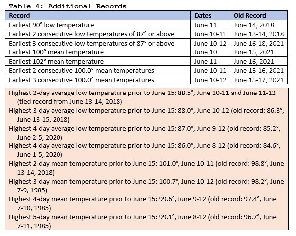
With today’s data, the pre-June 15 mean temperature records are now: 4 days: 100.3; 5 days: 99.5. The lows are: 4 days: 88.5; 5 days: 87.6. -
Galveston’s Record Warm Late Spring and Early Summer
donsutherland1 replied to donsutherland1's topic in Climate Change
Yesterday (June 12), Galveston recorded a minimum temperature of 85°. That is the earliest such minimum temperature on record. The prior mark was 85°, which was set on June 21, 2019. From April 1-June 12, Galveston has had 29 record-breaking or record-tying minimum temperatures. -
Morning thoughts… It will be partly cloudy and very warm. High temperatures will reach the middle and upper 80s in most of the region. Likely high temperatures around the region include: New York City (Central Park): 84° Newark: 89° Philadelphia: 88° Through Friday, temperatures will be generally above normal.
-
Hottest Weather So Far Lies Ahead for Phoenix
donsutherland1 replied to donsutherland1's topic in Central/Western States
A quick summary of the early-season heat in Phoenix:
-
Tomorrow will be partly sunny and noticeably warmer. The remainder of the week will generally see somewhat above normal to above normal temperatures. Out west, additional high temperature records were tied or broken. Records included: Abilene, TX: 109° (old record: 106°, 1942) Cheyenne: 92° (tied record set in 1956) Phoenix: 113° (old record: 112°, 1918, 1933, 1936, 1974 and 2019) Salt Lake City: 102° (old record: 101°, 1918) San Antonio: 105° (tied record set in 1942) This heat will move into the Great Lakes region for a brief time during midweek. Temperatures from Chicago to Detroit could challenge or break daily record high temperatures. However, the core of the heat will not likely move into the Northeast. As a result, New York City will likely see temperatures peak in the middle and upper 80s. The ECMWF seasonal forecast indicates that the summer will be warmer than normal throughout the region and across much of North America. Based on how the pattern has been evolving during the spring transition to summer, it is more likely than not that the warmest anomalies of the summer will likely occur in July and August with June being the coolest of the three months in the Northeast. The latest ECMWF monthly forecast indicates that July will be warmer than June relative to normal and that August will be the warmest summer month relative to normal. The ENSO Region 1+2 anomaly was -0.6°C and the Region 3.4 anomaly was -0.9°C for the week centered around June 1. For the past six weeks, the ENSO Region 1+2 anomaly has averaged -1.33°C and the ENSO Region 3.4 anomaly has averaged -1.07°C. La Niña conditions will likely persist through the summer. The SOI was +8.58 today. The preliminary Arctic Oscillation (AO) was +1.066 today. On June 10 the MJO was in Phase 1 at an amplitude of 1.122 (RMM). The June 9-adjusted amplitude was 1.231 (RMM). Based on sensitivity analysis applied to the latest guidance, there is an implied 54% probability that New York City will have a warmer than normal June (1991-2020 normal). June will likely finish with a mean temperature near 72.4° (0.4° above normal).
-
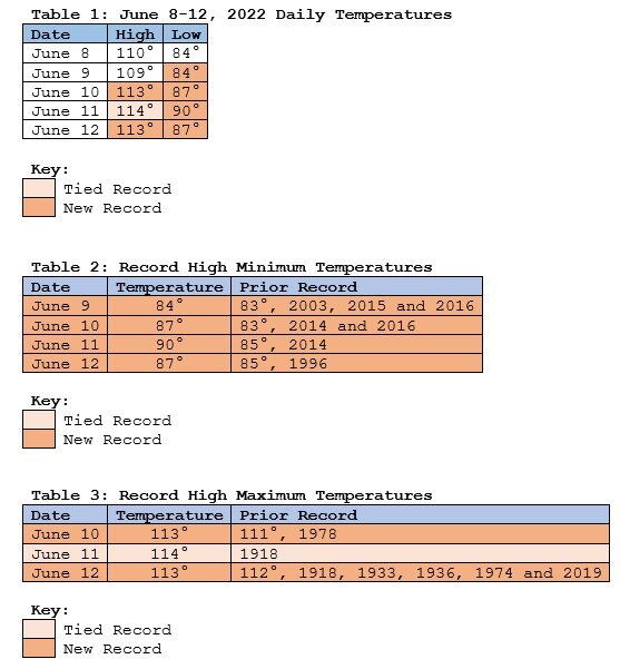
The June 8-12, 2022 period was the warmest 5-day period on record prior to June 15th. Four tables:
- 1 reply
-
- 1
-

-
Morning thoughts… It will be variably cloudy with showers and thunderstorms. High temperatures will reach the lower and middle 70s in most of the region. Likely high temperatures around the region include: New York City (Central Park): 78° Newark: 82° Philadelphia: 80° Tomorrow will be partly sunny and vey warm. Normals: New York City: 30-Year: 78.7°; 15-Year: 78.6° Newark: 30-Year: 80.8°; 15-Year: 80.9° Philadelphia: 30-Year: 82.3°; 15-Year: 82.5°
-
Tomorrow will be variably cloudy with frequent showers and thunderstorms. The remainder of the week will generally see somewhat above normal to above normal temperatures. Out west, numerous high temperature records were tied or broken. Records included: Abilene, TX: 108° (old record: 105°, 2012) Corpus Christi: 97° (tied record set in 2014) Dallas-Forth Worth: 103° (tied record set in 1911) Death Valley, CA: 122° (old record: 121°, 1921) Denver: 100° (tied record set in 2013) Flagstaff: 87° (tied record set in 1910) Las Vegas: 109° (old record: 108°, 1996) Phoenix: 114° (tied record set in 1910) San Antonio: 104° (tied record set in 1942) This morning, Phoenix also recorded a low temperature of 90°. That would smash the daily record of 85° from 2014 and would be the earliest 90° minimum temperature on record. The record was set on June 14, 2018 when the low temperature was 90°. Excessive heat will continue to grip the desert Southwest through tomorrow. Phoenix will very likely again see readings of 110° or above. Additional temperature records are possible. This heat will move into the Great Lakes region for a brief time during midweek. Temperatures from Chicago to Detroit could challenge or break daily record high temperatures. However, the heat will not move into the Northeast. The ECMWF seasonal forecast indicates that the summer will be warmer than normal throughout the region and across much of North America. Based on how the pattern has been evolving during the spring transition to summer, it is more likely than not that the warmest anomalies of the summer will likely occur in July and August with June being the coolest of the three months in the Northeast. The latest ECMWF monthly forecast indicates that July will be warmer than June relative to normal and that August will be the warmest summer month relative to normal. The ENSO Region 1+2 anomaly was -0.6°C and the Region 3.4 anomaly was -0.9°C for the week centered around June 1. For the past six weeks, the ENSO Region 1+2 anomaly has averaged -1.33°C and the ENSO Region 3.4 anomaly has averaged -1.07°C. La Niña conditions will likely persist through the summer. The SOI was +6.96 today. The preliminary Arctic Oscillation (AO) was +0.444 today. On June 9 the MJO was in Phase 1 at an amplitude of 1.231 (RMM). The June 8-adjusted amplitude was 1.528 (RMM). Based on sensitivity analysis applied to the latest guidance, there is an implied 57% probability that New York City will have a warmer than normal June (1991-2020 normal). June will likely finish with a mean temperature near 72.6° (0.6° above normal).
-
Hottest Weather So Far Lies Ahead for Phoenix
donsutherland1 replied to donsutherland1's topic in Central/Western States
This morning’s low temperature in Phoenix was 90. That would crush the daily record of 85 from 2014. It would also be the earliest 90 low on record. The record was set on June 14, 2018.
