

donsutherland1
-
Posts
24,154 -
Joined
Content Type
Profiles
Blogs
Forums
American Weather
Media Demo
Store
Gallery
Everything posted by donsutherland1
-
Much of the region sizzled under near record to record heat. High temperatures included: Albany: 92° (tied record set in 1941) Atlantic City: 93° (tied record set in 1996) Baltimore: 95° Islip: 90° (tied record set in 1996) New York City-JFK: 87° New York City-LGA: 91° New York City-NYC: 90° Newark: 95° Philadelphia: 95° (tied record set in 1934) Richmond: 95° (old record: 93°, 1934 and 1962) Scranton: 90° Sterling, VA: 92° (tied record set in 1996) Washington, DC: 92° Wilmington, DE: 95° (tied record set in 1996) Worcester: 88° (tied record set in 1975) New York City's first 80° or above temperature of the year was 90°. Only 1918, 1927, and 2010 saw 90° or above readings as Central Park's first 80° or above temperature. Records go back to 1869. Islip also saw its first 80° or above temperature of the year with a high of 90°. Only 1969 saw the first 80° temperature wind up as the first 90° or above temperature. Records go back to 1963. In Europe, Andujar, Spain recorded its second consecutive high of 107° in what is unprecedented May heat. The historic spring heat also continued in parts of India and Pakistan. Jacobabad reached 120° for the third consecutive day. Tomorrow will be another hot day. Areas on the immediate coastline where sea breezes occur may remain much cooler than interior sections. New York City and Newark could again see the mercury rise into the upper 80s and lower 90s. Thunderstorms are possible late in the day and during the evening as a cold front moves across the region. Behind the cold front, a much cooler air mass will overspread the region. During the middle of next week, high temperatures could struggle just to reach 70° in parts of the northern Middle Atlantic region. Overall, the second half of the month will likely be warmer than normal and there remains some possibility of an overall warm monthly outcome. The potential also exists for several very warm to perhaps hot days. The ECMWF seasonal forecast indicates that the summer will be warmer than normal throughout the region and across much of North America. The ENSO Region 1+2 anomaly was -1.4°C and the Region 3.4 anomaly was -1.1°C for the week centered around May 11. For the past six weeks, the ENSO Region 1+2 anomaly has averaged -1.57°C and the ENSO Region 3.4 anomaly has averaged -1.03°C. La Niña conditions will likely persist into the start of June. The SOI was +6.34 today. The preliminary Arctic Oscillation (AO) was +0.427 today. On May 19 the MJO was in Phase 8 at an amplitude of 1.303 (RMM). The May 18-adjusted amplitude was 1.261 (RMM). Based on sensitivity analysis applied to the latest guidance, there is an implied 57% probability that New York City will have a warmer than normal May (1991-2020 normal). May will likely finish with a mean temperature near 63.6° (0.4° above normal).
-
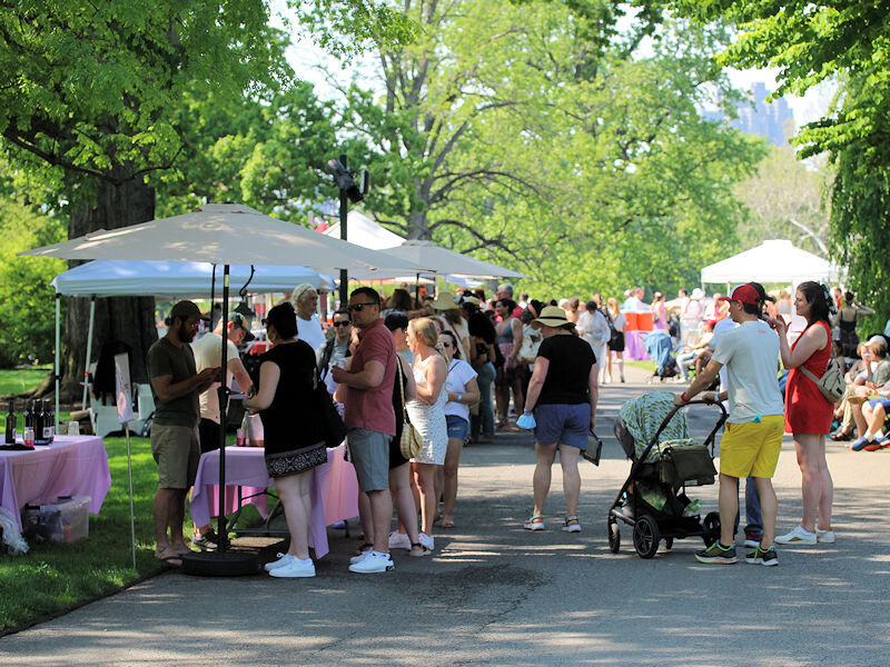
The temperature soared into the 90s in much of the NYC region. At the New York Botanical Garden, there was a wine festival and farmer’s market.


-
The issue usually becomes apparent around 2 pm during the summer and a little later during late May-early June.
-
Morning thoughts… Clouds and fog will give way to partly to mostly sunny skies. High temperatures will likely reach the upper 70s and lower 80s along the Connecticut shore to middle 90s in parts of New Jersey and southeastern Pennsylvania. Likely high temperatures around the region include: New York City (Central Park): 90° Newark: 95° Philadelphia: 95° Tomorrow will be another hot day before a cold front brings noticeably cooler weather starting Monday. Normals: New York City: 30-Year: 72.6°; 15-Year: 73.3° Newark: 30-Year: 73.9°; 15-Year: 74.8° Philadelphia: 30-Year: 75.7°; 15-Year: 76.4° Daily Records for May 21: Baltimore: 96°, 1934 Harrisburg: 95°, 1941 New York City-JFK: 90°, 1962 and 1996 New York City-LGA: 93°, 1996 New York City-NYC: 93°, 1996 Newark: 96°, 1996 Philadelphia: 95°, 1934 Washington, DC: 95°, 1934
-
Parts of the Middle Atlantic and Southeastern regions saw temperatures rise into the upper 80s and 90s today. Temperatures included: Baltimore: 90° Norfolk: 94° Philadelphia: 87° Raleigh: 96° (old record: 94°, 1938) Richmond: 97° (old record: 96°, 1934) Washington, DC: 89° Wilmington, NC: 95° (old record: 94°, 2000) That heat will expand into the northern Middle Atlantic region tomorrow. Some additional showers and thundershowers are likely overnight as the warm front pushes across the region. Following the frontal passage, the warmest weather of the year so far is in store for the weekend for parts of the region. Areas on the immediate coastline where sea breezes occur may remain much cooler than interior sections. New York City and Newark could see the mercury rise into the upper 80s and lower 90s. Overall, the second half of the month will likely be warmer than normal and there remains some possibility of an overall warm monthly outcome. The potential also exists for several very warm to perhaps hot days. The ECMWF seasonal forecast indicates that the summer will be warmer than normal throughout the region and across much of North America. The ENSO Region 1+2 anomaly was -1.4°C and the Region 3.4 anomaly was -1.1°C for the week centered around May 11. For the past six weeks, the ENSO Region 1+2 anomaly has averaged -1.57°C and the ENSO Region 3.4 anomaly has averaged -1.03°C. La Niña conditions will likely persist into the start of June. The SOI was +15.34 today. The preliminary Arctic Oscillation (AO) was +0.530 today. On May 18 the MJO was in Phase 8 at an amplitude of 1.281 (RMM). The May 17-adjusted amplitude was 1.264 (RMM). Based on sensitivity analysis applied to the latest guidance, there is an implied 62% probability that New York City will have a warmer than normal May (1991-2020 normal). May will likely finish with a mean temperature near 63.7° (0.5° above normal).
-
Central Park, at least, should make a run at 90. Whether it reaches it is a different matter. 70s would represent a more than 3 sigma modeling error from one day out.
-
Morning thoughts… Clouds and fog will give way to some sunshine. Late afternoon or overnight showers and thundershowers are possible. High temperatures will likely reach the upper 60s along the Connecticut shore to upper 80s in southeastern Pennsylvania. Likely high temperatures around the region include: New York City (Central Park): 74° Newark: 77° Philadelphia: 87° The weekend will likely see the warmest temperatures so far this season in many parts of the region. Many locations away from the water will see their first 90s of the year. Normals: New York City: 30-Year: 72.4°; 15-Year: 73.1° Newark: 30-Year: 73.6°; 15-Year: 74.5° Philadelphia: 30-Year: 75.4°; 15-Year: 76.1°
-
Mountain West Discussion
donsutherland1 replied to mayjawintastawm's topic in Central/Western States
Some additional late-season snowfall information for Denver.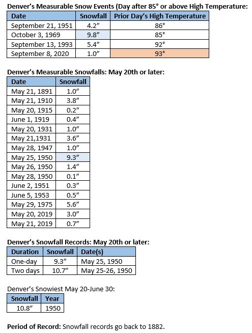
-
Tomorrow will be partly sunny and warmer. Temperatures will rise into the 70s throughout much of the region. Out West, Denver, which saw temperatures rise into the upper 80s today will see showers and rain turn to a heavy snowfall tomorrow night into Saturday. In the northern Middle Atlantic region, the warmest weather of the year so far is in store for the weekend for parts of the region. Areas on the immediate coastline where sea breezes occur may remain much cooler than interior sections. New York City and Newark could see the mercury rise into the upper 80s and lower 90s. Overall, the second half of the month will likely be warmer than normal and there remains some possibility of an overall warm monthly outcome. The potential also exists for several very warm to perhaps hot days. The ECMWF seasonal forecast indicates that the summer will be warmer than normal throughout the region and across much of North America. The ENSO Region 1+2 anomaly was -1.4°C and the Region 3.4 anomaly was -1.1°C for the week centered around May 11. For the past six weeks, the ENSO Region 1+2 anomaly has averaged -1.57°C and the ENSO Region 3.4 anomaly has averaged -1.03°C. La Niña conditions will likely persist into the start of June. The SOI was +13.19 today. The preliminary Arctic Oscillation (AO) was +0.830 today. On May 17 the MJO was in Phase 7 at an amplitude of 1.279 (RMM). The May 16-adjusted amplitude was 1.440 (RMM). Based on sensitivity analysis applied to the latest guidance, there is an implied 63% probability that New York City will have a warmer than normal May (1991-2020 normal). May will likely finish with a mean temperature near 63.7° (0.5° above normal).
-
Morning thoughts… Rain will end this morning. The clouds will break from west to east this afternoon. High temperatures will likely reach the upper 60s and lower 70s in much of the region. Southern New Jersey and southeastern Pennsylvania will see temperatures top out in the upper 70s and lower 80s. Likely high temperatures around the region include: New York City (Central Park): 68° Newark: 70° Philadelphia: 78° The weekend will likely see the warmest temperatures so far this season in many parts of the region. Normals: New York City: 30-Year: 72.1°; 15-Year: 72.9° Newark: 30-Year: 73.4°; 15-Year: 74.3° Philadelphia: 30-Year: 75.2°; 15-Year: 75.8°
-
Showers and periods of rain are likely overnight into early tomorrow. Clouds will break later tomorrow and readings will climb into the upper 60s and lower 70s. Afterward, the warmest weather of the year so far is in store for the weekend for parts of the region. Areas on the immediate coastline where sea breezes occur may remain much cooler than interior sections. New York City and Newark could see the mercury rise into the upper 80s and lower 90s. Overall, the second half of the month will likely be warmer than normal and there remains some possibility of an overall warm monthly outcome. The potential also exists for several very warm to perhaps hot days. The ECMWF seasonal forecast indicates that the summer will be warmer than normal throughout the region and across much of North America. The ENSO Region 1+2 anomaly was -1.4°C and the Region 3.4 anomaly was -1.1°C for the week centered around May 11. For the past six weeks, the ENSO Region 1+2 anomaly has averaged -1.57°C and the ENSO Region 3.4 anomaly has averaged -1.03°C. La Niña conditions will likely persist into the start of June. The SOI was +15.03 today. The preliminary Arctic Oscillation (AO) was +0.613 today. On May 16 the MJO was in Phase 7 at an amplitude of 1.440 (RMM). The May 15-adjusted amplitude was 1.686 (RMM). Based on sensitivity analysis applied to the latest guidance, there is an implied 62% probability that New York City will have a warmer than normal May (1991-2020 normal). May will likely finish with a mean temperature near 63.7° (0.5° above normal).
-
Morning thoughts… Clouds will increase during the afternoon or evening. Some showers and periods of rain are likely overnight into tomorrow. High temperatures will likely reach the lower and middle 70s in much of the region. Likely high temperatures around the region include: New York City (Central Park): 72° Newark: 74° Philadelphia: 74° The weekend will likely see the warmest temperatures so far this season in many parts of the region. Normals: New York City: 30-Year: 71.9°; 15-Year: 72.7° Newark: 30-Year: 73.1°; 15-Year: 74.0° Philadelphia: 30-Year: 74.9°; 15-Year: 75.6°
-
Slightly cooler weather will continue through Thursday. Afterward, the warmest weather of the year so far is possible next weekend for parts of the region. Areas on the immediate coastline where sea breezes occur may remain much cooler than interior sections. Overall, the second half of the month will likely be warmer than normal and there remains some possibility of an overall warm monthly outcome. The potential also exists for several very warm to perhaps hot days. The ECMWF seasonal forecast indicates that the summer will be warmer than normal throughout the region and across much of North America. The ENSO Region 1+2 anomaly was -1.4°C and the Region 3.4 anomaly was -1.1°C for the week centered around May 11. For the past six weeks, the ENSO Region 1+2 anomaly has averaged -1.57°C and the ENSO Region 3.4 anomaly has averaged -1.03°C. La Niña conditions will likely persist into the start of June. The SOI was +24.45 today. The preliminary Arctic Oscillation (AO) was +0.267 today. On May 15 the MJO was in Phase 6 at an amplitude of 1.688 (RMM). The May 14-adjusted amplitude was 1.653 (RMM). Based on sensitivity analysis applied to the latest guidance, there is an implied 55% probability that New York City will have a warmer than normal May (1991-2020 normal). May will likely finish with a mean temperature near 63.5° (0.3° above normal).
-
Morning thoughts… It will be mostly sunny and warm. High temperatures will likely reach the middle and upper 70s in much of the region. Likely high temperatures around the region include: New York City (Central Park): 77° Newark: 79° Philadelphia: 81° Tomorrow and Thursday will be somewhat cooler. The weekend could see the warmest temperatures so far this season in many parts of the region. Normals: New York City: 30-Year: 71.7°; 15-Year: 72.5° Newark: 30-Year: 72.8°; 15-Year: 73.8° Philadelphia: 30-Year: 74.6°; 15-Year: 75.3°
-
For a time, it will likely turn cooler. The month could end with above normal temperatures.
-
Following today's passage of a cold front, slightly cooler weather will follow for tomorrow through Thursday. Afterward, the warmest weather of the year so far is possible next weekend for parts of the region. Areas on the immediate coastline may remain much cooler than interior sections. Overall, the second half of the month will likely be warmer than normal and there remains some possibility of an overall warm monthly outcome. The potential also exists for several very warm to perhaps hot days. The ECMWF seasonal forecast indicates that the summer will be warmer than normal throughout the region and across much of North America. The ENSO Region 1+2 anomaly was -1.4°C and the Region 3.4 anomaly was -1.1°C for the week centered around May 11. For the past six weeks, the ENSO Region 1+2 anomaly has averaged -1.57°C and the ENSO Region 3.4 anomaly has averaged -1.03°C. La Niña conditions will likely persist into the start of June. The SOI was +20.39 today. The preliminary Arctic Oscillation (AO) was +0.267 today. On May 14 the MJO was in Phase 5 at an amplitude of 1.656 (RMM). The May 13-adjusted amplitude was 1.698 (RMM). Based on sensitivity analysis applied to the latest guidance, there is an implied 52% probability that New York City will have a warmer than normal May (1991-2020 normal). May will likely finish with a mean temperature near 63.4° (0.2° above normal).
-
Morning thoughts… It will be partly sunny and warm. A cold front will bring strong to severe thunderstorms this afternoon or evening to many parts of the region. High temperatures will likely reach the middle and upper 70s in much of the region. Likely high temperatures around the region include: New York City (Central Park): 75° Newark: 78° Philadelphia: 81° Somewhat cooler air will follow the frontal passage for tomorrow through Thursday. Normals: New York City: 30-Year: 71.4°; 15-Year: 72.3° Newark: 30-Year: 72.6°; 15-Year: 73.5° Philadelphia: 30-Year: 74.4°; 15-Year: 75.1°
-
Morning thoughts… Morning fog will give way to variably cloudy skies. It will be warmer. High temperatures will likely reach the middle and upper 70s in much of the region. Likely high temperatures around the region include: New York City (Central Park): 77° Newark: 79° Philadelphia: 81° Tomorrow will be variably cloudy and warm. Strong to perhaps severe thunderstorms are likely. Normals: New York City: 30-Year: 71.2°; 15-Year: 72.0° Newark: 30-Year: 72.3°; 15-Year: 73.2° Philadelphia: 30-Year: 74.1°; 15-Year: 74.8°
-
Clouds broke in parts of the New York City area sending temperatures into the 70s. Islip reached 76°. A few showers overspread the region from south to north during the late afternoon and evening. Up north, temperatures rose into the 80s and even 90s. High temperatures included: Albany: 84° Bangor: 91° (old record: 87°, 1961) Boston: 86° (tied record set in 1879) Burlington: 88° (old record: 86°, 1961) Caribou: 82° (old record: 81°, 1961) ***4th consecutive record high*** Concord: 89° Hartford: 84° Manchester, NH: 91° (old record: 81°, 2004 and 2018) Montreal: 87° (old record: 85°, 2004) Portland: 84° (old record: 81°, 1961) Tomorrow will see more sunshine with readings rising into the middle and perhaps upper 70s. Monday will be very warm, but there will be the risk of strong thunderstorms as a cold front crosses the region. After a slight cooldown during the middle of next week, the warmest weather of the year so far is possible next weekend. Overall, the second half of the month will likely be warmer than normal and there remains some possibility of an overall warm monthly outcome. The potential also exists for several very warm to perhaps hot days. The ECMWF seasonal forecast indicates that the summer will be warmer than normal throughout the region and across much of North America. The ENSO Region 1+2 anomaly was -1.9°C and the Region 3.4 anomaly was -1.1°C for the week centered around April 27. For the past six weeks, the ENSO Region 1+2 anomaly has averaged -1.30°C and the ENSO Region 3.4 anomaly has averaged -0.93°C. La Niña conditions will likely persist into the start of June. The SOI was +19.25 today. The preliminary Arctic Oscillation (AO) was +2.432 today. On May 12 the MJO was in Phase 5 at an amplitude of 1.621 (RMM). The May 11-adjusted amplitude was 1.372 (RMM). Based on sensitivity analysis applied to the latest guidance, there is an implied 57% probability that New York City will have a warmer than normal May (1991-2020 normal). May will likely finish with a mean temperature near 63.6° (0.4° above normal).
-
Morning thoughts… Today could be a near carbon copy of yesterday. It will be mostly cloudy and mild. There could be some fog and also some showers. Most of the day will be dry. High temperatures will likely reach the upper 60s and lower 70s in much of the region. Likely high temperatures around the region include: New York City (Central Park): 72° Newark: 74° Philadelphia: 73° Tomorrow will be variably cloudy and warmer. Normals: New York City: 30-Year: 71.0°; 15-Year: 71.8° Newark: 30-Year: 72.1°; 15-Year: 73.0° Philadelphia: 30-Year: 73.9°; 15-Year: 74.5°
-
The New York City area saw mainly cloudy conditions with a few breaks in the clouds. Temperatures reached the lower 70s. Yet again, record high temperatures fell from the Midwest to Canada. Records included: Buffalo: 85° (tied record set in 2004 and tied in 2011 and 2014) Burlington: 88° (old record: 84°, 1985) Caribou: 90° (old record: 78°, 1992) ***2nd earliest 90° temperature*** Chicago: 89° (tied record set in 1956 and tied in 1991) Fredericton, NB: 85° (old record: 81°, 1969) La Tuque, QC: 91° (old record: 88°, 1977) Madison: 92° (old record: 88°, 1977) ***Earliest 4-day heatwave by 16 days*** Manchester, NH: 88° (old record: 84°, 2012) Moline, IL: 94° (old record: 91°, 1915) Montreal: 87° (old record: 83°, 1992) Ottawa: 86° (old record: 83°, 1985) Quebec City: 88° (old record: 74°, 1998) Rivière-du-Loup, QC: 80° (old record: 69°, 1998) Rockford, IL: 92° (old record: 88°, 1940 and 1991) Sherbrooke, QC: 86° (old record: 70°, 2008) Trois-Rivières, QC: 88° (old record: 72°, 2016) Tomorrow will be mostly cloudy with perhaps another shower or two. Temperatures will top out in the upper 60s and lower 70s. Sunday will see more sunshine with readings rising into the middle and perhaps upper 70s. Overall, the second half of the month will likely be warmer than normal and there remains some possibility of an overall warm monthly outcome. The potential also exists for several very warm to perhaps hot days. The ECMWF seasonal forecast indicates that the summer will be warmer than normal throughout the region and across much of North America. The ENSO Region 1+2 anomaly was -1.9°C and the Region 3.4 anomaly was -1.1°C for the week centered around April 27. For the past six weeks, the ENSO Region 1+2 anomaly has averaged -1.30°C and the ENSO Region 3.4 anomaly has averaged -0.93°C. La Niña conditions will likely persist into the start of June. The SOI was +24.45 today. The preliminary Arctic Oscillation (AO) was +3.304 today. That surpassed the old daily record +2.708 from 1992. On May 11 the MJO was in Phase 5 at an amplitude of 1.364 (RMM). The May 10-adjusted amplitude was 1.048 (RMM). Based on sensitivity analysis applied to the latest guidance, there is an implied 52% probability that New York City will have a warmer than normal May (1991-2020 normal). May will likely finish with a mean temperature near 63.3° (0.1° above normal).
-
Morning thoughts… It will be mostly cloudy and mild. There could be some fog and also some showers. Most of the day will be dry. High temperatures will likely reach the upper 60s and lower 70s in much of the region. Likely high temperatures around the region include: New York City (Central Park): 70° Newark: 71° Philadelphia: 75° The weekend could start with another mainly cloudy day, but partial sunshine is likely on Sunday. Normals: New York City: 30-Year: 70.7°; 15-Year: 71.6° Newark: 30-Year: 71.8°; 15-Year: 72.7° Philadelphia: 30-Year: 73.6°; 15-Year: 74.3°
-
Under variably cloudy skies, temperatures again rose into the 70s across much of the region. Record heat again prevailed from the Midwest into Canada. Records included: Bangor: 85° (old record: 83°, 1991) Burlington: 89° (old record: 84°, 2004) Caribou: 81° (old record: 78°, 1992) Eau Claire, WI: 94° (old record: 92°, 1900) Madison: 93° (old record: 86°, 1991) ***Earliest heatwave on record*** Moline, IL: 95° (old record: 94°, 1956) Montreal: 86° (old record: 81°, 1992) Ottawa: 85° (old record: 82°, 1992) Plattsburgh, NY: 85° (old record: 83°, 1956) Quebec City: 81° (old record: 76°, 2016) Rivière-du-Loup, QC: 75° (old record: 70°, 2016) Rockford, IL: 93° (old record: 88°, 1896) Sherbrooke, QC: 86° (old record: 66°, 2006) St. Louis: 93° (old record: 92°, 1956) Syracuse: 85° (old record: 84°, 1985, 1993, and 2014) Trois-Rivières: 85° (old record: 71°, 2012) Tomorrow will be mostly cloudy with some showers. Temperatures will top out in the upper 60s and lower 70s. Temperatures will likely reach the 70s on both days during the weekend. However, record-challenging or record-breaking temperatures will stay to the north and west of the region. Overall, the second half of the month will likely be warmer than normal and there remains some possibility of an overall warm monthly outcome. The ECMWF seasonal forecast indicates that the summer will be warmer than normal throughout the region and across much of North America. The ENSO Region 1+2 anomaly was -1.9°C and the Region 3.4 anomaly was -1.1°C for the week centered around April 27. For the past six weeks, the ENSO Region 1+2 anomaly has averaged -1.30°C and the ENSO Region 3.4 anomaly has averaged -0.93°C. La Niña conditions will likely persist into the start of June. The SOI was +32.80 today. That was a May record 3rd consecutive day with an SOI figure at or above +30.00. The old record was set during May 9-10, 2000 and tied during May 27-28, 2010 and May 16-17, 2013. The preliminary Arctic Oscillation (AO) was +3.313 today. That surpassed the old daily record +2.942 from 1992. On May 10 the MJO was in Phase 4 at an amplitude of 1.042 (RMM). The May 9-adjusted amplitude was 0.984 (RMM). Based on sensitivity analysis applied to the latest guidance, there is an implied 48% probability that New York City will have a warmer than normal May (1991-2020 normal). May will likely finish with a mean temperature near 63.1° (0.1° below normal).
-
Weather Trivia: With Caribou reaching 80 degrees, 2022 has become the first year during which Chicago reached 90 degrees (5/11) and Caribou reached 80 degrees (5/12) before Central Park reported its first 80-degree temperature of the year.
-
Morning thoughts… It will be variably cloudy and mild. High temperatures will likely reach the upper 60s and lower 70s in much of the region. Likely high temperatures around the region include: New York City (Central Park): 71° Newark: 73° Philadelphia: 72° Tomorrow will be mostly cloudy with the risk of a shower. Normals: New York City: 30-Year: 70.5°; 15-Year: 71.3° Newark: 30-Year: 71.5°; 15-Year: 72.4° Philadelphia: 30-Year: 73.4°; 15-Year: 74.0°

