

donsutherland1
-
Posts
24,154 -
Joined
Content Type
Profiles
Blogs
Forums
American Weather
Media Demo
Store
Gallery
Everything posted by donsutherland1
-
Tomorrow will be variably cloudy and mild. Friday will be unseasonably warm before somewhat cooler air returns for the start of the weekend. The expected development of blocking will likely result in a return of cooler than normal conditions during the closing days of April into the beginning of May. During the 1991-2020 period, the April 25-May 5 period saw temperatures average 1°-2° below normal when strong blocking coincided with Niña conditions. Afterward, approximately 50% of such cases went on to see a warmer to much warmer than normal second half of May. The ENSO Region 1+2 anomaly was -1.7°C and the Region 3.4 anomaly was -0.9°C for the week centered around April 13. For the past six weeks, the ENSO Region 1+2 anomaly has averaged -0.80°C and the ENSO Region 3.4 anomaly has averaged -0.88°C. La Niña conditions will likely persist into the start of June. The ENSO Region 1+2 anomaly of -1.7°C is the lowest such figure on record for a week centered around April 13. The old record was -1.4°C, which was set in 1994. Since 1982, there were five prior cases where the ENSO Region 1+2 anomaly was -1.5°C or colder. 40% of those cases saw La Niña conditions the following winter; 40% saw neutral-cool ENSO conditions that approached but did not reach La Niña status. 20% of those cases saw an El Niño develop during the following winter. More immediately, the magnitude of cool anomalies implies that the proverbial stage is set for an active to very active Atlantic hurricane season. The SOI was +27.69 today. The preliminary Arctic Oscillation (AO) was +0.096 today. On April 18 the MJO was in Phase 1 at an amplitude of 1.316 (RMM). The April 17-adjusted amplitude was 1.192 (RMM). Based on sensitivity analysis applied to the latest guidance, there is an implied 70% probability that New York City will have a cooler than normal April (1991-2020 normal). April will likely finish with a mean temperature near 53.2° (0.5° below normal).
-
Morning thoughts… It will be mostly sunny and somewhat milder today. High temperatures will likely reach the middle and upper 50s in much of the region. Likely high temperatures around the region include: New York City (Central Park): 56° Newark: 58° Philadelphia: 61° The warming trend will continue tomorrow. Normals: New York City: 30-Year: 63.8°; 15-Year: 64.1° Newark: 30-Year: 64.5°; 15-Year: 64.9° Philadelphia: 30-Year: 66.6°; 15-Year: 67.0°
-
Clouds reluctantly yielded to sunshine during the afternoon. Temperatures remained much below normal. Tomorrow will be another cool day, though it will be somewhat milder. After midweek, milder conditions will develop. However, the possible development of blocking could result in a return of cooler than normal conditions after a short period of warmer than normal temperatures. The ENSO Region 1+2 anomaly was -1.7°C and the Region 3.4 anomaly was -0.9°C for the week centered around April 13. For the past six weeks, the ENSO Region 1+2 anomaly has averaged -0.80°C and the ENSO Region 3.4 anomaly has averaged -0.88°C. La Niña conditions will likely persist into the start of June. The ENSO Region 1+2 anomaly of -1.7°C is the lowest such figure on record for a week centered around April 13. The old record was -1.4°C, which was set in 1994. Since 1982, there were five prior cases where the ENSO Region 1+2 anomaly was -1.5°C or colder. 40% of those cases saw La Niña conditions the following winter; 40% saw neutral-cool ENSO conditions that approached but did not reach La Niña status. 20% of those cases saw an El Niño develop during the following winter. More immediately, the magnitude of cool anomalies implies that the proverbial stage is set for an active to very active Atlantic hurricane season. The SOI was +20.26 today. During April 5-14, the SOI had a 10-day stretch during which the SOI was +20.00 or above. The last time a streak of 7 or more such days occurred in April was March 28-April 5, 2011 when the SOI reached at least +20.00 on 9 consecutive days. Then, there was a brief period of much warmer than normal temperatures following the end of that stretch and a longer period of much warmer than normal temperatures starting about 2 1/2 weeks later. If such timing holds, much warmer conditions could develop sometime during the first week in May. The preliminary Arctic Oscillation (AO) was +0.874 today. On April 17 the MJO was in Phase 1 at an amplitude of 1.192 (RMM). The April 16-adjusted amplitude was 1.292 (RMM). Based on sensitivity analysis applied to the latest guidance, there is an implied 60% probability that New York City will have a cooler than normal April (1991-2020 normal). April will likely finish with a mean temperature near 53.5° (0.2° below normal).
-
Spring Snowstorm Obs. 4/18-4/19
donsutherland1 replied to BuffaloWeather's topic in Upstate New York/Pennsylvania
Elevantion notwithstanding, it was an amazing event. Based on some of last night's radar, the snow fell really heavily at times (probably near 3" per hour in spots). -
Spring Snowstorm Obs. 4/18-4/19
donsutherland1 replied to BuffaloWeather's topic in Upstate New York/Pennsylvania
The NWS Binghamton measurement shows 14.2" of snow for Binghamton. That would surpass the existing April record of 13.9" from April 15-17, 2007. The two-day mark is 13.6" from April 15-16, 2007, which would also be exceeded. -
Spring Snowstorm Obs. 4/18-4/19
donsutherland1 replied to BuffaloWeather's topic in Upstate New York/Pennsylvania
Updated select accumulations: Location ST Event Type Mag. 1 SW VIRGIL NY HEAVY SNOW 18.0 ERIEVILLE NY HEAVY SNOW 16.3 MONTROSE PA HEAVY SNOW 14.5 HARFORD NY HEAVY SNOW 14.5 5 WSW MEREDITH NY SNOW 14.5 NWS BINGHAMTON NY HEAVY SNOW 14.2 SOUTH PLYMOUTH NY HEAVY SNOW 14.0 4 ESE AFTON NY HEAVY SNOW 14.0 3 SSE CLAYVILLE NY HEAVY SNOW 14.0 SOLON NY HEAVY SNOW 13.8 PARIS NY HEAVY SNOW 13.5 NORWICH NY HEAVY SNOW 13.5 PORT CRANE NY HEAVY SNOW 13.0 MARYLAND NY HEAVY SNOW 13.0 BRACKNEY PA HEAVY SNOW 13.0 4 WNW WINDSOR NY HEAVY SNOW 12.5 WINDSOR NY HEAVY SNOW 12.0 ONEONTA NY HEAVY SNOW 12.0 DIMOCK PA SNOW 12.0 CANDOR NY HEAVY SNOW 12.0 -
Spring Snowstorm Obs. 4/18-4/19
donsutherland1 replied to BuffaloWeather's topic in Upstate New York/Pennsylvania
282 NOUS41 KBGM 190856 PNSBGM NYZ009-015>018-022>025-036-037-044>046-055>057-062-PAZ038>040-043-044-047- 048-072-192056- PUBLIC INFORMATION STATEMENT NATIONAL WEATHER SERVICE BINGHAMTON NY 456 AM EDT TUE APR 19 2022 ...SNOWFALL REPORTS... LOCATION AMOUNT TIME/DATE PROVIDER ...NEW YORK... ...BROOME COUNTY... WINDSOR 12.0 IN 0340 AM 04/19 PUBLIC NWS BINGHAMTON 10.3 IN 0430 AM 04/19 OFFICIAL NWS OBS 2 SW VESTAL CENTER 9.0 IN 0330 AM 04/19 NWS EMPLOYEE 2 WNW VESTAL CENTER 8.8 IN 0445 AM 04/19 PUBLIC NWS BINGHAMTON 8.4 IN 0300 AM 04/19 OFFICIAL NWS OBS PORT DICKINSON 6.0 IN 0337 AM 04/19 NWS EMPLOYEE 1 SE PORT CRANE 5.5 IN 0130 AM 04/19 WHITNEY POINT 5.0 IN 0300 AM 04/19 PUBLIC 1 N JOHNSON CITY 4.5 IN 0230 AM 04/19 BROADCAST MEDIA 4 W WINDSOR 3.0 IN 0300 AM 04/19 PUBLIC NWS BINGHAMTON 3.0 IN 0100 AM 04/19 OFFICIAL NWS OBS ...CHENANGO COUNTY... OXFORD 7.0 IN 0300 AM 04/19 PUBLIC 3 SE GREENE 6.5 IN 0215 AM 04/19 TRAINED SPOTTER 1 W PHARSALIA 1.5 IN 1140 PM 04/18 PUBLIC ...CORTLAND COUNTY... HOMER 1.0 IN 0132 AM 04/19 TRAINED SPOTTER ...ONEIDA COUNTY... WHITESBORO 4.7 IN 0430 AM 04/19 TRAINED SPOTTER ...OTSEGO COUNTY... MARYLAND 13.0 IN 0300 AM 04/19 PUBLIC OTEGO 10.0 IN 0210 AM 04/19 PUBLIC UNADILLA 7.5 IN 0325 AM 04/19 PUBLIC ...SULLIVAN COUNTY... KIAMESHA 4.1 IN 0435 AM 04/19 TRAINED SPOTTER ...TIOGA COUNTY... 3 NE RICHFORD 4.0 IN 1220 AM 04/19 PUBLIC ...PENNSYLVANIA... ...PIKE COUNTY... SHOHOLA 1.6 IN 0200 AM 04/19 PUBLIC ...SUSQUEHANNA COUNTY... MONTROSE 12.0 IN 0449 AM 04/19 PUBLIC MONTROSE 10.0 IN 0140 AM 04/19 PUBLIC && -
Morning thoughts… Clouds and showers will give way to partly sunny skies. It will be windy and cool. High temperatures will likely reach the lower and middle 50s in much of the region. Likely high temperatures around the region include: New York City (Central Park): 52° Newark: 54° Philadelphia: 55° Milder air will return after midweek. Normals: New York City: 30-Year: 63.4°; 15-Year: 63.7° Newark: 30-Year: 64.2°; 15-Year: 64.5° Philadelphia: 30-Year: 66.2°; 15-Year: 66.6°
-
Plain rain in Larchmont, NY.
-
On this date in 1887, a storm dumped 3" of snow in New York City. This time around, a storm will bring snow to an area running from Pennsylvania into northern New England and a heavy windswept rain to the coastal plain tonight into early tomorrow. A general 0.50"-1.50" rainfall with locally higher amounts in excess of 2.00" is likely. Winds could gust past 50 mph. Snow is likely in the higher elevations and in the interior. The Poconos, Catskills, and Adirondacks could see an appreciable accumulation of snow. Seasonal snowfall amounts to date include: Albany: 33.6" (25.2" below normal) Allentown: 19.5" (33.6" below normal) Baltimore: 14.4" (4.9" below normal) Binghamton: 67.2" (18.3" below normal) Boston: 54.0" (5.0" above normal) Bridgeport: 27.7" (5.8" below normal) Buffalo: 96.0" (1.0" above normal) Burlington: 66.5" (20.0" below normal) Caribou: 120.1" (4.5" above normal) Harrisburg: 16.4" (13.4" below normal) Islip: 37.0" (5.3" above normal) New York City: 17.9" (11.9" below normal) Newark: 17.9" (13.6" below normal) Philadelphia: 12.9" (10.2" below normal) Portland: 44.1" (24.2" below normal) Providence: 43.5" (7.0" above normal) Washington, DC: 13.2" (0.5" below normal) After midweek, milder conditions will develop. The ENSO Region 1+2 anomaly was -1.7°C and the Region 3.4 anomaly was -0.9°C for the week centered around April 13. For the past six weeks, the ENSO Region 1+2 anomaly has averaged -0.80°C and the ENSO Region 3.4 anomaly has averaged -0.88°C. La Niña conditions will likely persist into the start of June. The ENSO Region 1+2 anomaly of -1.7°C is the lowest such figure on record for a week centered around April 13. The old record was -1.4°C, which was set in 1994. Since 1982, there were five prior cases where the ENSO Region 1+2 anomaly was -1.5°C or colder. 40% of those cases saw La Niña conditions the following winter; 40% saw neutral-cool ENSO conditions that approached but did not reach La Niña status. 20% of those cases saw an El Niño develop during the following winter. More immediately, the magnitude of cool anomalies implies that the proverbial stage is set for an active to very active Atlantic hurricane season. The SOI was +20.19 today. During April 5-14, the SOI had a 10-day stretch during which the SOI was +20.00 or above. The last time a streak of 7 or more such days occurred in April was March 28-April 5, 2011 when the SOI reached at least +20.00 on 9 consecutive days. Then, there was a brief period of much warmer than normal temperatures following the end of that stretch and a longer period of much warmer than normal temperatures starting about 2 1/2 weeks later. The preliminary Arctic Oscillation (AO) was +0.917 today. On April 16 the MJO was in Phase 8 at an amplitude of 1.293 (RMM). The April 15-adjusted amplitude was 1.012 (RMM). Based on sensitivity analysis applied to the latest guidance, there is an implied 50% probability that New York City will have a warmer than normal April (1991-2020 normal). April will likely finish with a mean temperature near 53.7° (normal).
-
Central PA Spring 2022
donsutherland1 replied to Itstrainingtime's topic in Upstate New York/Pennsylvania
It's snowing and the ground is covered in State College. https://www.statecollege.com/webcams/college-avenue-camera/ -
2021-2022 ENSO
donsutherland1 replied to StormchaserChuck!'s topic in Weather Forecasting and Discussion
That's a growing possibility. It's not yet cast in stone, but the odds have increased. -
2021-2022 ENSO
donsutherland1 replied to StormchaserChuck!'s topic in Weather Forecasting and Discussion
The ENSO Region 1+2 anomaly was -1.7C for the week centered around April 13th. That is the coldest anomaly for that timeframe since weekly records were kept beginning in 1982. The prior mark was -1.4C in 1994. -
Morning thoughts… Clouds will increase during the day and rain will likely arrive late in the day. Overnight into tomorrow morning, there will be a windswept heavy rain. Higher elevations and interior sections will likely see some snow. High temperatures will likely reach the lower and middle 50s in much of the region. Likely high temperatures around the region include: New York City (Central Park): 53° Newark: 54° Philadelphia: 54° The cool weather will continue through at least midweek. Normals: New York City: 30-Year: 63.0°; 15-Year: 63.3° Newark: 30-Year: 63.8°; 15-Year: 64.1° Philadelphia: 30-Year: 65.8°; 15-Year: 66.3° At Bismarck, 2.5” of snow fell yesterday. That broke the daily record of 2.1” from 1959. It also increased the snowfall for this month to 21.9”, making 2022 the snowiest April on record. The old record of 21.8” was set in 2013. April records go back to 1875.
-
Today featured brilliant sunshine but unseasonably cool readings. The colder than normal readings will likely persist through at least midweek. Before then, a storm could bring a windswept rain to the region tomorrow night into Tuesday. A general 0.50"-1.50" rainfall with some locally higher amounts appears likely. Snow is likely in the higher elevations and in the interior. The Poconos, Catskills, and Adirondacks could see at least an appreciable accumulation of snow. The ENSO Region 1+2 anomaly was -1.1°C and the Region 3.4 anomaly was -0.9°C for the week centered around April 6. For the past six weeks, the ENSO Region 1+2 anomaly has averaged -0.73°C and the ENSO Region 3.4 anomaly has averaged -0.92°C. La Niña conditions will likely persist into the start of May. The SOI was +18.75 today. During April 5-14, the SOI had a 10-day stretch during which the SOI was +20.00 or above. The last time a streak of 7 or more such days occurred in April was March 28-April 5, 2011 when the SOI reached at least +20.00 on 9 consecutive days. Then, there was a brief period of much warmer than normal temperatures following the end of that stretch and a longer period of much warmer than normal temperatures starting about 2 1/2 weeks later. The preliminary Arctic Oscillation (AO) was +0.782 today. On April 15 the MJO was in Phase 8 at an amplitude of 1.014 (RMM). The April 14-adjusted amplitude was 0.828 (RMM). Based on sensitivity analysis applied to the latest guidance, there is an implied 57% probability that New York City will have a warmer than normal April (1991-2020 normal). April will likely finish with a mean temperature near 54.0° (0.3° above normal).
-
Morning thoughts… It will be mainly sunny and much cooler today. High temperatures will likely reach the lower and middle 50s in much of the region. Likely high temperatures around the region include: New York City (Central Park): 52° Newark: 53° Philadelphia: 56° A cold rain will develop late tomorrow or tomorrow and continue into Tuesday. Higher elevations and interior sections could see some snow. Normals: New York City: 30-Year: 62.6°; 15-Year: 62.9° Newark: 30-Year: 63.4°; 15-Year: 63.7° Philadelphia: 30-Year: 65.5°; 15-Year: 65.9°
-
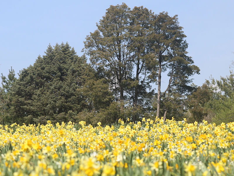
With the thermometer topping 70 degrees under bright sunshine, the spring celebration of color was well underway at the New York Botanical Garden.


-
The temperature again rose into the upper 60s and lower 70s in much of the region courtesy of bright sunshine. But the spring party is coming to an end as a cold front moves eastward across central Pennsylvania and central New York State. Following the frontal passage, which will be marked by some showers or even thundershowers, noticeably cooler air will pour into the region tonight and persist through at least the middle of next week. A storm could bring a cold rain to the region early next week with some snow possible in the higher elevations and in the interior. The ENSO Region 1+2 anomaly was -1.1°C and the Region 3.4 anomaly was -0.9°C for the week centered around April 6. For the past six weeks, the ENSO Region 1+2 anomaly has averaged -0.73°C and the ENSO Region 3.4 anomaly has averaged -0.92°C. La Niña conditions will likely persist into the start of May. The SOI was +16.44 today. During April 5-14, the SOI had a 10-day stretch during which the SOI was +20.00 or above. The last time a streak of 7 or more such days occurred in April was March 28-April 5, 2011 when the SOI reached at least +20.00 on 9 consecutive days. Then, there was a brief period of much warmer than normal temperatures following the end of that stretch and a longer period of much warmer than normal temperatures starting about 2 1/2 weeks later. The preliminary Arctic Oscillation (AO) was +0.260 today. On April 14 the MJO was in Phase 8 at an amplitude of 0.827 (RMM). The April 13-adjusted amplitude was 0.627 (RMM). Based on sensitivity analysis applied to the latest guidance, there is an implied 55% probability that New York City will have a warmer than normal April (1991-2020 normal). April will likely finish with a mean temperature near 54.0° (0.3° above normal).
-
The final low temperature at Bismarck was 0F (-17.8C). That was the coldest temperature so late in the season. The previous latest such temperature occurred on April 5, 1996 with a low temperature -1F (-18.3C).
-
Morning thoughts… Clouds will increase this afternoon. Showers and thunderstorms are likely late this afternoon or this evening. High temperatures will likely reach the upper 60s and lower 70s in much of the region. Likely high temperatures around the region include: New York City (Central Park): 68° Newark: 71° Philadelphia: 73° It will be noticeably cooler tomorrow despite ample sunshine. Normals: New York City: 30-Year: 62.2°; 15-Year: 62.5° Newark: 30-Year: 62.9°; 15-Year: 63.3° Philadelphia: 30-Year: 65.1°; 15-Year: 65.5° Through 6 am CDT, the low temperature at Bismarck is 1°. That smashes the daily record low of 10°, which was set in 1953. It is also the coldest temperature so late in the season. The previous latest such temperature occurred on April 9, 1997 when the temperature also fell to 1°.
-
Under bright sunshine temperatures rose into the upper 60s and lower 70s across the region. Tomorrow will be another warm day. However, a strong cold front will slice across the region bringing showers and perhaps gusty thunderstorms. Noticeably cooler air will then pour into the region and persist through at least the middle of next week. The duration and magnitude of the upcoming cool spell could determine whether April finishes with a cool or warm anomaly. The ENSO Region 1+2 anomaly was -1.1°C and the Region 3.4 anomaly was -0.9°C for the week centered around April 6. For the past six weeks, the ENSO Region 1+2 anomaly has averaged -0.73°C and the ENSO Region 3.4 anomaly has averaged -0.92°C. La Niña conditions will likely persist into the start of May. The SOI was +19.54 today. That ended the 10-day stretch during which the SOI was +20.00 or above. The last time a streak of 7 or more such days occurred in April was March 28-April 5, 2011 when the SOI reached at least +20.00 on 9 consecutive days. Then, there was a brief period of much warmer than normal temperatures following the end of that stretch and a longer period of much warmer than normal temperatures starting about 2 1/2 weeks later. The preliminary Arctic Oscillation (AO) was -0.178 today. On April 13 the MJO was in Phase 7 at an amplitude of 0.630 (RMM). The April 12-adjusted amplitude was 0.750 (RMM). Based on sensitivity analysis applied to the latest guidance, there is an implied 50% probability that New York City will have a warmer than normal April (1991-2020 normal). April will likely finish with a mean temperature near 53.7° (normal).
-
Morning thoughts… It will be partly to mostly sunny and warm today. High temperatures will likely reach the upper 60s and lower 70s in much of the region. Likely high temperatures around the region include: New York City (Central Park): 67° Newark: 69° Philadelphia: 70° The unseasonable warmth will continue into the start of the weekend. Normals: New York City: 30-Year: 61.8°; 15-Year: 62.1° Newark: 30-Year: 62.5°; 15-Year: 62.9° Philadelphia: 30-Year: 64.7°; 15-Year: 65.1°
-
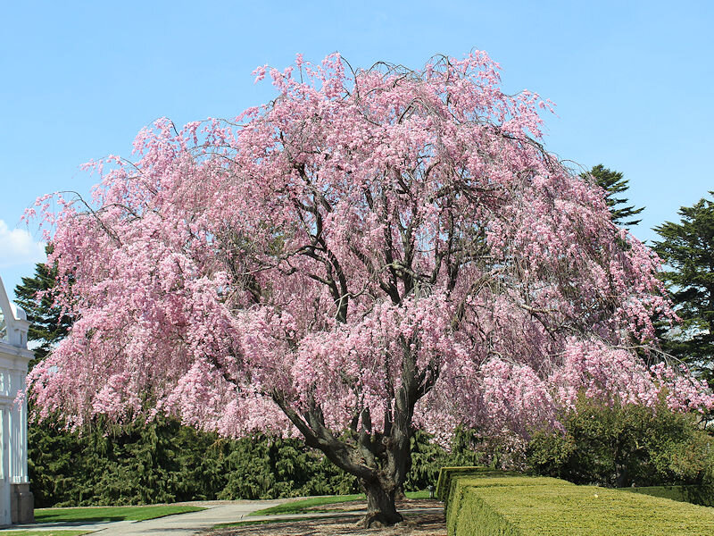
From the New York Botanical Garden early this afternoon:
-
Under partly sunny skies, temperatures soared into the upper 70s and lower 80s away from the coastline. Newark reached 88°, which tied the daily record set in 1941. Thunderstorms moved through the region during the late afternoon and early evening as a front came eastward. Following the frontal passage, tomorrow and Saturday will remain on the warm side of normal. However, a strong cold front will slice across the region on Saturday bringing showers and perhaps gusty thunderstorms. Noticeably cooler air will then pour into the region and persist through at least the middle of next week. The duration and magnitude of the upcoming cool spell could determine whether April finishes with a cool or warm anomaly. The ENSO Region 1+2 anomaly was -1.1°C and the Region 3.4 anomaly was -0.9°C for the week centered around April 6. For the past six weeks, the ENSO Region 1+2 anomaly has averaged -0.73°C and the ENSO Region 3.4 anomaly has averaged -0.92°C. La Niña conditions will likely persist into the start of May. The SOI was +21.63 today. Today was the 10th consecutive day that the SOI was +20.00 or above. The last time that happened was January 8-17, 2011 when the SOI reached +20.00 or above on 10 consecutive days. This is only the 7th time on record that the SOI has been at or above +20.00 for at least 10 consecutive days. Daily figures go back to 1991. The last time a streak of 7 or more such days occurred in April was March 28-April 5, 2011 when the SOI reached at least +20.00 on 9 consecutive days. Then, there was a brief period of much warmer than normal temperatures following the end of that stretch and a longer period of much warmer than normal temperatures starting about 2 1/2 weeks later. The preliminary Arctic Oscillation (AO) was -0.459 today. On April 12 the MJO was in Phase 7 at an amplitude of 0.750 (RMM). The April 11-adjusted amplitude was 0.712 (RMM). Based on sensitivity analysis applied to the latest guidance, there is an implied 45% probability that New York City will have a warmer than normal April (1991-2020 normal). April will likely finish with a mean temperature near 53.5° (0.2° below normal).
-
It's good to see some of the Minot area numbers starting to come in. That was where the heaviest snow was expected to fall.

