donsutherland1
-
Posts
24,152 -
Joined
Content Type
Profiles
Blogs
Forums
American Weather
Media Demo
Store
Gallery
Everything posted by donsutherland1
-
Morning thoughts… It will be partly cloudy and somewhat cooler. A few locations could see a shower or thundershower. High temperatures will reach the lower and middle 80s in most of the region. Likely high temperatures around the region include: New York City (Central Park): 83° Newark: 85° Philadelphia: 88° Tomorrow and Tuesday will see showers and thunderstorms. Some of the rain will be heavy. Normals: New York City: 30-Year: 82.9°; 15-Year: 82.7° Newark: 30-Year: 84.2°; 15-Year: 84.3° Philadelphia: 30-Year: 85.4°; 15-Year: 85.1°
-
Mountain West Discussion
donsutherland1 replied to mayjawintastawm's topic in Central/Western States
During August 21-23, 1967, Shreveport picked up 3.83" of rain when no tropical cyclones were present. However, the high rainfall totals were nowhere near as widespread as modeled for the upcoming event. Much lower amounts were recorded in northern Texas. -
Mountain West Discussion
donsutherland1 replied to mayjawintastawm's topic in Central/Western States
It might be record-setting if the numbers from the maps you posted verify. I will have to see if I can find other non-tropical cases of such excessive rainfall. -
Mountain West Discussion
donsutherland1 replied to mayjawintastawm's topic in Central/Western States
Through 5:40 pm MST, the Friday-Saturday monsoon rainfall has been disappointing in Phoenix and Tucson. Monsoon total rainfall for June 15-August 20 is: Phoenix: 1.34” (normal: 1.53”) and Tucson: 2.36” (normal: 3.66”). -
Cooler air will begin to move into the region tomorrow. Early next week will see some unsettled weather with showers and thundershowers. Much of the second half of August could see above to much above normal temperatures in the Pacific Northwest. The ECMWF seasonal forecast indicates that the summer will be warmer than normal throughout the region and across much of North America. Based on how the pattern has been evolving during the spring transition to summer, it is more likely than not that the warmest anomalies of the summer will likely occur in July and August with June being the coolest of the three months in the Northeast. In addition, in the 6 past cases when the June AO averaged +0.750 or above (1950-2021), 67% of the following August and September cases featured above normal temperatures. The August ECMWF forecast shows a warmer than normal September in the Northeast. This warmth would be consistent with the ongoing warming that has been occurring in September. On August 18, the SOI fell to -32.90. Since 1991, there were 8 cases when the SOI fell to -30 or below during the August 10-25 period. That outcome has often preceded a wetter than normal September in parts of the Northeast. Mean September rainfall figures for those 8 cases: Boston: 4.38" (normal: 3.55"); New York City: 5.08" (normal: 4.31"); and, Philadelphia: 5.12" (normal: 4.40"). Very wet years outnumbered very dry ones by a 2:1 ratio in Boston and 3:1 ratio in both New York City and Philadelphia. 63% of cases saw at least one day with 1" or more rainfall in Boston. 88% saw at least one day with 1" or more in New York City and Philadelphia. 50% of those cases saw at least one day with 2" or more daily rainfall in Philadelphia. In sum, the SOI may be offering a signal that there will be some drought relief for the northern Mid-Atlantic and southern New England regions in September. The ENSO Region 1+2 anomaly was -0.5°C and the Region 3.4 anomaly was -1.1°C for the week centered around August 10. For the past six weeks, the ENSO Region 1+2 anomaly has averaged -0.90°C and the ENSO Region 3.4 anomaly has averaged -0.77°C. La Niña conditions will likely persist through the fall. The SOI was -4.98 today. The preliminary Arctic Oscillation (AO) was -0.644 today. On August 18 the MJO was in Phase 1 at an amplitude of 0.495 (RMM). The August 17-adjusted amplitude was 0.480 (RMM). Based on sensitivity analysis applied to the latest guidance, there is an implied 92% probability that New York City will have a warmer than normal August (1991-2020 normal). August will likely finish with a mean temperature near 78.5° (2.4° above normal).
-
Temperatures were in the middle 80s at Robert Moses State Park. Overall, it was a great beach day.
-
Morning thoughts… It will be partly sunny and very warm. A few locations could see a shower or thundershower. High temperatures will reach the upper 80s and lower 90s in most of the region. Likely high temperatures around the region include: New York City (Central Park): 89° Newark: 92° Philadelphia: 93° It will turn cooler tomorrow. Normals: New York City: 30-Year: 83.0°; 15-Year: 82.8° Newark: 30-Year: 84.4°; 15-Year: 84.5° Philadelphia: 30-Year: 85.5°; 15-Year: 85.2°
-
Tomorrow will be another very warm day. However, cooler air will begin to move into the region for Sunday. Much of the second half of August could see above to much above normal temperatures in the Pacific Northwest. The ECMWF seasonal forecast indicates that the summer will be warmer than normal throughout the region and across much of North America. Based on how the pattern has been evolving during the spring transition to summer, it is more likely than not that the warmest anomalies of the summer will likely occur in July and August with June being the coolest of the three months in the Northeast. In addition, in the 6 past cases when the June AO averaged +0.750 or above (1950-2021), 67% of the following August and September cases featured above normal temperatures. The August ECMWF forecast shows a warmer than normal September in the Northeast. This warmth would be consistent with the ongoing warming that has been occurring in September. On August 18, the SOI fell to -32.90. Since 1991, there were 8 cases when the SOI fell to -30 or below during the August 10-25 period. That outcome has often preceded a wetter than normal September in parts of the Northeast. Mean September rainfall figures for those 8 cases: Boston: 4.38" (normal: 3.55"); New York City: 5.08" (normal: 4.31"); and, Philadelphia: 5.12" (normal: 4.40"). Very wet years outnumbered very dry ones by a 2:1 ratio in Boston and 3:1 ratio in both New York City and Philadelphia. 63% of cases saw at least one day with 1" or more rainfall in Boston. 88% saw at least one day with 1" or more in New York City and Philadelphia. 50% of those cases saw at least one day with 2" or more daily rainfall in Philadelphia. In sum, the SOI may be offering a signal that there will be some drought relief for the northern Mid-Atlantic and southern New England regions in September. The ENSO Region 1+2 anomaly was -0.5°C and the Region 3.4 anomaly was -1.1°C for the week centered around August 10. For the past six weeks, the ENSO Region 1+2 anomaly has averaged -0.90°C and the ENSO Region 3.4 anomaly has averaged -0.77°C. La Niña conditions will likely persist through the fall. The SOI was -15.78 today. The preliminary Arctic Oscillation (AO) was -0.877 today. On August 17 the MJO was in Phase 8 at an amplitude of 0.479 (RMM). The August 16-adjusted amplitude was 0.226 (RMM). Based on sensitivity analysis applied to the latest guidance, there is an implied 88% probability that New York City will have a warmer than normal August (1991-2020 normal). August will likely finish with a mean temperature near 78.2° (2.1° above normal).
-
Hottest Weather So Far Lies Ahead for Phoenix
donsutherland1 replied to donsutherland1's topic in Central/Western States
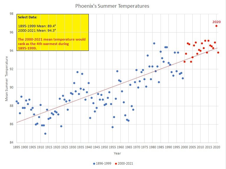
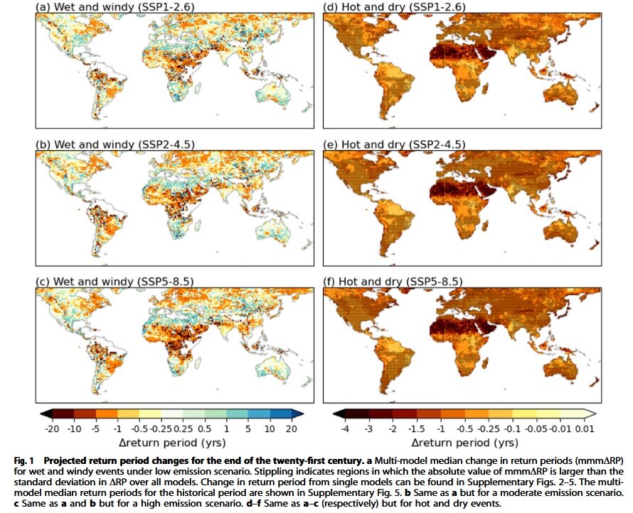
That is an ill-informed comment. A factual assessment follows. First, although most people are indoors at night, there are populations that are not (select occupations such as construction and the homeless). Their health and lives matter, too (at least in an ethical framework that treats all lives as having value). Frivolous dismissals of an issue that is being discussed by scientists and policymakers, including Phoenix's Mayor Kate Gallego, as "bizarre" doesn't make that issue disappear. Flippant dismissals don't make the problem of anthropogenic climate change, which the IPCC described as "unequivocal, vanish. Second, temperatures and temperature records are not mere abstract numbers that have no significance or meaning beyond the data. They have a real impact. The Southwest's and Phoenix's rising heat poses growing health and societal challenges. The Fourth National Climate Assessment explained: Extreme heat episodes in much of the region disproportionately threaten the health and well-being of individuals and populations who are especially vulnerable... Vulnerability arises from numerous factors individually or in combination, including physical susceptibility (for example, young children and older adults), excessive exposure to heat (such as during heat waves), and socioeconomic factors that influence susceptibility and exposure (for example, hot and poorly ventilated homes or lack of access to public emergency cooling centers)... Communicable diseases, ground-level ozone air pollution, dust storms, and allergens can combine with temperature and precipitation extremes to generate multiple disease burdens (an indicator of the impact of a health problem). Episodes of extreme heat can affect transportation by reducing the ability of commercial airlines to gain sufficient lift for takeoff at major regional airports. Those are real, not imaginary, consequences. Discussing such matter is not even close to "bizarre." Dismissing or denying them is worse than bizarre. Moreover, the Fifth Assessment that will be published in 2023 will sharpen the language related to heat-, drought-, and wildfire-related impacts, all of which are interrelated. Further, compound heat-drought events are projected to increase in the Southwest. Source: Ridder et al., 2022. More than half of Phoenix's warmest months on record have occurred since 2010, including July 2022. The 2010-2022 period accounts for a disproportionate share of exceptionally hot months, as Phoenix's records go back to August 1895. Summers have been warming dramatically. 5 of the 10 hottest summers and 11 of the 20 hottest summers have occurred since 2010. Moreover, the 2000-2021 summer average temperature would rank as the 4th warmest summer during the entire 1895-1999 period. Half of the summers during 2000-2021 were hotter than the hottest summer during the 1895-1999 period. Extremely hot nights (minimum temperatures of 90° or above) were once very uncommon. During 1895-1999, 22% of years saw such minimum temperatures. Every year during 2000-2021 has seen one or more such days. The last time one was not recorded was in 1991. The annual average was 0.5 days during 1895-1999. During 2000-2021, it rocketed to 9.7 days. Diverting attention from the warming of Southwest climate in general, and Phoenix's climate in particular, does not discount the critical and growing importance of an issue that is well-supported by science and well-documented in the climate record. That there has been some welcome monsoon relief that eases the ongoing multi-year drought does not erase what is a growing and increasingly urgent issue confronting the Southwest. Moreover, the monsoon relief may dent but very likely won't erase the now 9" rainfall deficit that has accumulated from January 2015 through mid-August 2022 in the Phoenix area. Much more rain will be needed to end the drought. The coming La Niña winter won't necessarily bring the kind of winter-spring precipitation that is needed. As for the insults in the comment, they merely illustrate the unserious nature of the comment. Fortunately, policymakers are not treating the issue as an "irrelevant" game. They have real responsibilities for the lives of the residents they serve and the economies that provide livelihoods for those people. They understand what's at stake. They are working to protect health, lives, and local economies. Already, Phoenix has developed a Climate Action Plan, which is hardly what one would expect were the issue "irrelevant." In conclusion, the issue of Phoenix's and the Southwest's increasing heat is highly relevant. Internet or Social Media posts don't render it invalid. As long as it is a valid and important issue, I will highlight it when necessary or appropriate, as readers should have opportunity to be exposed to relevant developments, along with the facts.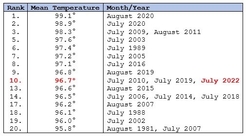
-
Morning thoughts… It will be partly sunny and very warm. High temperatures will reach the upper 80s and lower 90s in most of the region. Likely high temperatures around the region include: New York City (Central Park): 89° Newark: 92° Philadelphia: 91° After another very warm day tomorrow, somewhat cooler air will arrive to conclude the weekend. Normals: New York City: 30-Year: 83.2°; 15-Year: 83.0° Newark: 30-Year: 84.5°; 15-Year: 84.6° Philadelphia: 30-Year: 85.6°; 15-Year: 85.4°
-
Hottest Weather So Far Lies Ahead for Phoenix
donsutherland1 replied to donsutherland1's topic in Central/Western States
It certainly is an important part of the story. I have some family just outside of Phoenix. The growth has been remarkable. -
This morning the temperature fell to 62° in New York City's Central Park. That was the coolest reading since June 23 when the thermometer registered 61°. Under bright sunshine, the temperature rebounded into the middle 80s and upper 80s during the afternoon. Newark reached 90°. Tomorrow will be a very warm day. Many parts of the region could approach or reach 90°. Another cooler air mass could move into the region Saturday night or Sunday. Much of the second half of August could see above to much above normal temperatures in the Pacific Northwest. The ECMWF seasonal forecast indicates that the summer will be warmer than normal throughout the region and across much of North America. Based on how the pattern has been evolving during the spring transition to summer, it is more likely than not that the warmest anomalies of the summer will likely occur in July and August with June being the coolest of the three months in the Northeast. In addition, in the 6 past cases when the June AO averaged +0.750 or above (1950-2021), 67% of the following August and September cases featured above normal temperatures. The August ECMWF forecast shows a warmer than normal September in the Northeast. This warmth would be consistent with the ongoing warming that has been occurring in September. On August 18, the SOI fell to -32.90. Since 1991, there were 8 cases when the SOI fell to -30 or below during the August 10-25 period. That outcome has often preceded a wetter than normal September in parts of the Northeast. Mean September rainfall figures for those 8 cases: Boston: 4.38" (normal: 3.55"); New York City: 5.08" (normal: 4.31"); and, Philadelphia: 5.12" (normal: 4.40"). Very wet years outnumbered very dry ones by a 2:1 ratio in Boston and 3:1 ratio in both New York City and Philadelphia. 63% of cases saw at least one day with 1" or more rainfall in Boston. 88% saw at least one day with 1" or more in New York City and Philadelphia. 50% of those cases saw at least one day with 2" or more daily rainfall in Philadelphia. In sum, the SOI may be offering a signal that there will be some drought relief for the northern Mid-Atlantic and southern New England regions in September. The ENSO Region 1+2 anomaly was -0.5°C and the Region 3.4 anomaly was -1.1°C for the week centered around August 10. For the past six weeks, the ENSO Region 1+2 anomaly has averaged -0.90°C and the ENSO Region 3.4 anomaly has averaged -0.77°C. La Niña conditions will likely persist through the fall. The SOI was -32.90 today. That was the lowest figure since June 20, 2020 when the SOI was -33.95. The preliminary Arctic Oscillation (AO) was -0.885 today. On August 16 the MJO was in Phase 7 at an amplitude of 0.227 (RMM). The August 15-adjusted amplitude was 0.070 (RMM). Based on sensitivity analysis applied to the latest guidance, there is an implied 84% probability that New York City will have a warmer than normal August (1991-2020 normal). August will likely finish with a mean temperature near 78.0° (1.9° above normal).
-
Texas/Oklahoma Discussion & Obs Thread 2022
donsutherland1 replied to It's Always Sunny's topic in Central/Western States
At Galveston, the heatwave that began on July 2nd has now reached 48 days. That ties the record set during July 3-August 19, 2015 for the longest heatwave. -
Hottest Weather So Far Lies Ahead for Phoenix
donsutherland1 replied to donsutherland1's topic in Central/Western States
That’s correct regarding the absence of nighttime relief. The arrival of the monsoonal rains and cooler conditions has been life-saving in the Phoenix area. Prior to then, the year was off to an especially deadly start. https://www.azfamily.com/2022/07/19/heat-deaths-maricopa-county-hit-half-year-record/?outputType=amp It is a myth that Phoenix’s increasing heat and rapid rise in very warm nights (80° lows have increased from 46.5 days per year to 74.0 days per year from 1961-1990 to 1991-2020; 90° lows have increased from 1.1 days to 7.4 days during that same period) isn’t hazardous to human health/life. Mayor Gallego, among other City leaders, is correct in focusing on Phoenix’s warming climate. -
Mountain West Discussion
donsutherland1 replied to mayjawintastawm's topic in Central/Western States
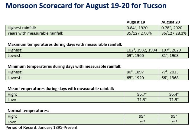
August 19-20 could feature heavy monsoonal rains in Phoenix and Tucson. The potential exists for 1" or more daily rainfall at both cities on at least one day. Monsoon Scorecards for both cities are below.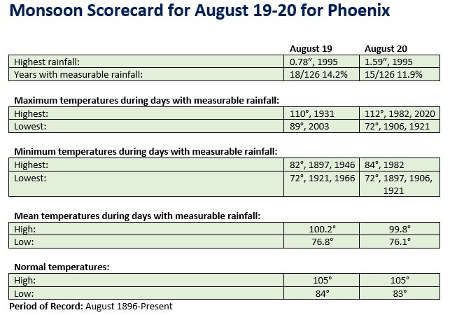
-
Occasional Thoughts on Climate Change
donsutherland1 replied to donsutherland1's topic in Climate Change
Summer 1936 and Summer 2021 are currently tied for hottest summer according to the NOAA's most recent ranking. In the larger scheme of things, most of the hot summers (mean temperature of 73° or above) have occurred since 2000. 10/13 (77%) have occurred since 2000, including 7/13 (54%) have occurred since 2010. Only 1934, 1936, and 1988 had mean temperatures of 73° or above prior to 2000. Ongoing climate change is leading to an outcome where such summers are becoming the new "normal." Summer 2022 could join that list.
-
Morning thoughts… It will be partly sunny and warmer. High temperatures will reach the middle and upper 80s in most of the region. Likely high temperatures around the region include: New York City (Central Park): 84° Newark: 90° Philadelphia: 88° Warmer than normal readings will continue into the start of the weekend before cooler air returns on Sunday. Normals: New York City: 30-Year: 83.3°; 15-Year: 83.1° Newark: 30-Year: 84.6°; 15-Year: 84.8° Philadelphia: 30-Year: 85.8°; 15-Year: 85.5°
-
An offshore storm brought plenty of clouds to the region today. A few locations saw some drizzle or showers. Out West, Boise recorded its 20th 100° day of the year. That tied the record set in 2003. 9 of Boise's 10 warmest summers have occurred since 2000. Records go back to 1875. Salt Lake City further extended its annual record of 100° days to 23 days. Generally cooler than normal conditions will persist through tomorrow. Afterward, a warmup is likely, though no excessive heat will occur through at least the weekend. Much of the second half of August could see above to much above normal temperatures in the Pacific Northwest. The ECMWF seasonal forecast indicates that the summer will be warmer than normal throughout the region and across much of North America. Based on how the pattern has been evolving during the spring transition to summer, it is more likely than not that the warmest anomalies of the summer will likely occur in July and August with June being the coolest of the three months in the Northeast. In addition, in the 6 past cases when the June AO averaged +0.750 or above (1950-2021), 67% of the following August and September cases featured above normal temperatures. The August ECMWF forecast shows a warmer than normal September in the Northeast. This warmth would be consistent with the ongoing warming that has been occurring in September. The ENSO Region 1+2 anomaly was -0.5°C and the Region 3.4 anomaly was -1.1°C for the week centered around August 10. For the past six weeks, the ENSO Region 1+2 anomaly has averaged -0.90°C and the ENSO Region 3.4 anomaly has averaged -0.77°C. La Niña conditions will likely persist through the fall. The SOI was -6.74 today. The preliminary Arctic Oscillation (AO) was -1.036 today. On August 15 the MJO was in Phase 1 at an amplitude of 0.074 (RMM). The August 14-adjusted amplitude was 0.294 (RMM). Based on sensitivity analysis applied to the latest guidance, there is an implied 81% probability that New York City will have a warmer than normal August (1991-2020 normal). August will likely finish with a mean temperature near 78.0° (1.9° above normal).
-
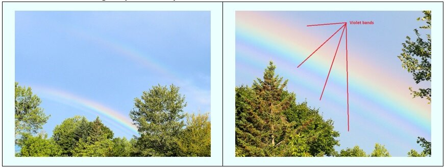
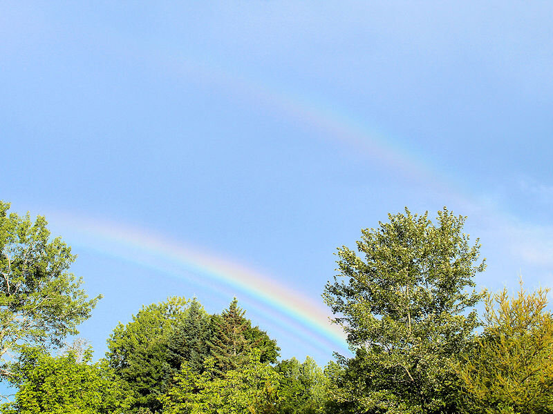
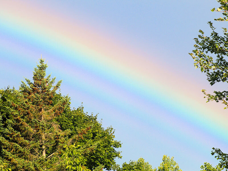
During a recent trip to Maine, I encountered a double rainbow. The lower rainbow was a supernumerary rainbow.
-
Morning thoughts… It will be variably cloudy and somewhat cooler than normal. A few places could see some showers. High temperatures will reach the upper 70s and lower 80s in most of the region. Likely high temperatures around the region include: New York City (Central Park): 79° Newark: 82° Philadelphia: 84° Cooler than normal conditions will persist through tomorrow before near normal and somewhat above normal temperatures return. Normals: New York City: 30-Year: 83.4°; 15-Year: 83.3° Newark: 30-Year: 84.7°; 15-Year: 85.0° Philadelphia: 30-Year: 85.9°; 15-Year: 85.7°
-
Today featured bright sunshine and pleasant temperatures in the lower and middle 80s. In the West, Salt Lake City recorded its 22nd 100° day. That broke the annual record of 21 days, which was set in 1960 and tied in 1994 and 2021. Generally cooler than normal conditions will persist through Thursday. Afterward, a warmup is likely, though no excessive heat will occur through at least the weekend. Much of the second half of August could see above to much above normal temperatures in the Pacific Northwest. The ECMWF seasonal forecast indicates that the summer will be warmer than normal throughout the region and across much of North America. Based on how the pattern has been evolving during the spring transition to summer, it is more likely than not that the warmest anomalies of the summer will likely occur in July and August with June being the coolest of the three months in the Northeast. In addition, in the 6 past cases when the June AO averaged +0.750 or above (1950-2021), 67% of the following August and September cases featured above normal temperatures. The August ECMWF forecast shows a warmer than normal September in the Northeast. The ENSO Region 1+2 anomaly was -0.5°C and the Region 3.4 anomaly was -1.1°C for the week centered around August 10. For the past six weeks, the ENSO Region 1+2 anomaly has averaged -0.90°C and the ENSO Region 3.4 anomaly has averaged -0.77°C. La Niña conditions will likely persist through the fall. The SOI was +9.04 today. The preliminary Arctic Oscillation (AO) was -1.291 today. On August 14 the MJO was in Phase 2 at an amplitude of 0.296 (RMM). The August 13-adjusted amplitude was 0.337 (RMM). Based on sensitivity analysis applied to the latest guidance, there is an implied 77% probability that New York City will have a warmer than normal August (1991-2020 normal). August will likely finish with a mean temperature near 77.8° (1.7° above normal).
-
Morning thoughts… It will be partly cloudy and somewhat cooler than normal. High temperatures will reach the lower and middle 80s in most of the region. Likely high temperatures around the region include: New York City (Central Park): 81° Newark: 85° Philadelphia: 83° Cooler than normal conditions will persist through Thursday before near normal and somewhat above normal temperatures return. Normals: New York City: 30-Year: 83.5°; 15-Year: 83.4° Newark: 30-Year: 84.9°; 15-Year: 85.1° Philadelphia: 30-Year: 86.0°; 15-Year: 85.8°
-
Rainbows at Stetson, ME on the morning of August 14 during a brief shower.
-
Generally cooler than normal conditions will persist through the week. Afterward, a warmup is likely, though no excessive heat will occur through at least the weekend. Much of the second half of August could see above to much above normal temperatures in the Pacific Northwest. The ECMWF seasonal forecast indicates that the summer will be warmer than normal throughout the region and across much of North America. Based on how the pattern has been evolving during the spring transition to summer, it is more likely than not that the warmest anomalies of the summer will likely occur in July and August with June being the coolest of the three months in the Northeast. In addition, in the 6 past cases when the June AO averaged +0.750 or above (1950-2021), 67% of the following August and September cases featured above normal temperatures. The August ECMWF forecast shows a warmer than normal September in the Northeast. The ENSO Region 1+2 anomaly was -0.5°C and the Region 3.4 anomaly was -1.1°C for the week centered around August 10. For the past six weeks, the ENSO Region 1+2 anomaly has averaged -0.90°C and the ENSO Region 3.4 anomaly has averaged -0.77°C. La Niña conditions will likely persist through the fall. The SOI was +13.96 today. The preliminary Arctic Oscillation (AO) was -1.021 today. On August 13 the MJO was in Phase 2 at an amplitude of 0.345 (RMM). The August 12-adjusted amplitude was 0.213 (RMM). Based on sensitivity analysis applied to the latest guidance, there is an implied 74% probability that New York City will have a warmer than normal August (1991-2020 normal). August will likely finish with a mean temperature near 77.7° (1.6° above normal).
-
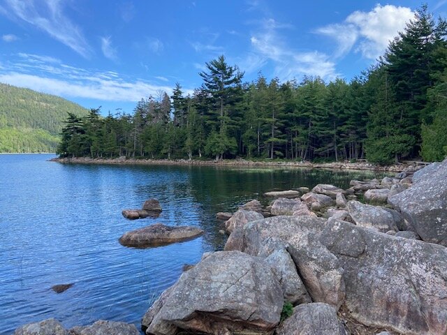
High temperatures in central Maine have been running similar to those in NYC during the past few days (upper 70s and lower 80s). Nights have been cooler (upper 50s and lower 60s). From Acadia National Park: