

donsutherland1
-
Posts
24,192 -
Joined
Content Type
Profiles
Blogs
Forums
American Weather
Media Demo
Store
Gallery
Everything posted by donsutherland1
-
I believe Environment Canada issued those warnings. https://www.canada.ca/en/environment-climate-change/services/hurricane-forecasts-facts.html
- 1,529 replies
-
- 2
-

-
- hurricane
- tropical storm
- (and 1 more)
-
There’s a real chance. I suspect that Fiona’s expanding circulation will help drive cool air into the region. 40s in September have become infrequent. Since 2000, only 2006, 2009, 2013, and 2020 have seen the temperature dip below 50.
- 1,529 replies
-
- 2
-

-
-
- hurricane
- tropical storm
- (and 1 more)
-
In many parts of the region, today was the coolest day since late Spring. In New York City's Central Park, the mercury topped out at 63°. The last time the high temperature was at least as cool was May 8th when the temperature reached 58°. Newark's high temperature of 64° was the lowest since May 8th when the high was just 62°. Select low temperatures from this morning included: Boston: 50° (coolest since May 26: 50°) New York City: 51° (coolest since May 10: 51°) Newark: 50° (coolest since May 10: 50°) Philadelphia: 56° (coolest since May 26: 54°) After another very cool start, tomorrow will be somewhat warmer with readings reaching the upper 60s and lower 70s. Sunday and Monday will see readings return to near to somewhat above normal levels. In part due to Merbok's impact on the jet stream, September will likely end with cooler than normal conditions. The cool weather could continue into the start of October. In southern Florida, near record and record heat prevailed. Miami reached 95°, which broke the daily mark of 94° from 1943. Today's 95° temperature was the second latest on record. It was also the second such temperature in September, which tied the monthly record set in 1989 and tied in 2019 and 2021. Florida faces a hurricane risk next week. Hurricane Fiona will make landfall in Atlantic Canada tomorrow. With a contribution from the ongoing marine heatwave, Fiona will likely do so as a category 2 hurricane. Canada's lowest barometric pressure on record could be challenged. The powerful storm could also sweep a surge of warm air northward along Greenland's west coast sending temperatures in some areas up to near 50°. In the 6 past cases when the June AO averaged +0.750 or above (1950-2021), 67% of the following August and September cases featured above normal temperatures. The August ECMWF forecast shows a warmer than normal September in the Northeast. This warmth would be consistent with the ongoing warming that has been occurring in September. The ENSO Region 1+2 anomaly was -0.9°C and the Region 3.4 anomaly was -1.0°C for the week centered around September 6. For the past six weeks, the ENSO Region 1+2 anomaly has averaged -0.62°C and the ENSO Region 3.4 anomaly has averaged -1.00°C. La Niña conditions will likely persist through the fall. The SOI was +14.80 today. The preliminary Arctic Oscillation (AO) was +0.341 today. On September 21 the MJO was in Phase 3 at an amplitude of 0.476 (RMM). The September 20-adjusted amplitude was 0.336 (RMM). Based on sensitivity analysis applied to the latest guidance, there is an implied 70% probability that New York City will have a warmer than normal September (1991-2020 normal). September will likely finish with a mean temperature near 69.9° (0.7° above normal).
- 1,529 replies
-
- 2
-
-
- hurricane
- tropical storm
- (and 1 more)
-
Almost certainly, the ongoing marine heatwave has put a category 3 scenario on the table for Nova Scotia. Without it, one would see a weaker but still potent storm.
- 1,529 replies
-
- 1
-
-
- hurricane
- tropical storm
- (and 1 more)
-
Morning thoughts… Today sunny but unseasonably cool. High temperatures will reach the middle 60s in most of the region. Likely high temperatures around the region include: New York City (Central Park): 64° Newark: 66° Philadelphia: 67° Tomorrow will be another cool day. Normals: New York City: 30-Year: 73.5°; 15-Year: 74.7° Newark: 30-Year: 75.1°; 15-Year: 76.3° Philadelphia: 30-Year: 76.3°; 15-Year: 77.4°
-
Texas/Oklahoma Discussion & Obs Thread 2022
donsutherland1 replied to It's Always Sunny's topic in Central/Western States
Through September 22, Galveston has 100 days on which the low temperature was 80°F or above. That is well above the old mark of 91 days, which was set in 2011. Very few locations in the mainland U.S. have ever seen 100 or more such days.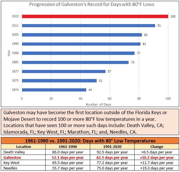
-
A strong cold front moved across the region during the morning and early afternoon bringing showers and thundershowers. In response, temperatures began falling even as the sun returned. Tomorrow, many parts of the region will experience their coldest temperatures so far this season. Temperatures will warm up during the second half of the weekend. However, in part due to Merbok's impact on the jet stream, September will likely end with cooler than normal conditions. During Saturday, Hurricane Fiona will likely make landfall in Atlantic Canada. With a contribution from the ongoing marine heatwave, Fiona will likely do so as a category 2 hurricane. Canada's lowest barometric pressure on record could be challenged. In the 6 past cases when the June AO averaged +0.750 or above (1950-2021), 67% of the following August and September cases featured above normal temperatures. The August ECMWF forecast shows a warmer than normal September in the Northeast. This warmth would be consistent with the ongoing warming that has been occurring in September. The ENSO Region 1+2 anomaly was -0.9°C and the Region 3.4 anomaly was -1.0°C for the week centered around September 6. For the past six weeks, the ENSO Region 1+2 anomaly has averaged -0.62°C and the ENSO Region 3.4 anomaly has averaged -1.00°C. La Niña conditions will likely persist through the fall. The SOI was +12.72 today. The preliminary Arctic Oscillation (AO) was +0.341 today. On September 20 the MJO was in Phase 3 at an amplitude of 0.336 (RMM). The September 19-adjusted amplitude was 0.365 (RMM). Based on sensitivity analysis applied to the latest guidance, there is an implied 61% probability that New York City will have a warmer than normal September (1991-2020 normal). September will likely finish with a mean temperature near 69.9° (0.7° above normal).
- 1,529 replies
-
- 2
-
-
- hurricane
- tropical storm
- (and 1 more)
-
Texas/Oklahoma Discussion & Obs Thread 2022
donsutherland1 replied to It's Always Sunny's topic in Central/Western States
The temperature reached 95°F today in Galveston, which tied the daily record set in 2005. Today's 90° or above reading further extended this year's record for such days to 105. That number has increased as Galveston's climate has warmed.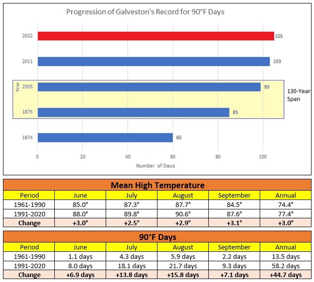
-
Morning thoughts… Today will be variably cloudy and cooler. Showers or thundershowers are possible this morning into early this afternoon. High temperatures will reach the middle 70s in most of the region. Likely high temperatures around the region include: New York City (Central Park): 75° Newark: 77° Philadelphia: 79° Tomorrow will be sharply cooler with temperatures topping out in the 60s across the region. Normals: New York City: 30-Year: 73.9°; 15-Year: 75.0° Newark: 30-Year: 75.5°; 15-Year: 76.7° Philadelphia: 30-Year: 76.7°; 15-Year: 77.7°
-
Following a pleasantly warm day, cooler weather is on the way. Parts of the region will see their coldest temperatures so far this season on Friday. Temperatures will warm up during the second half of the weekend. However, there is an increasing probability that the month could end with cooler than normal conditions. During late Friday night or early Saturday morning, Hurricane Fiona will likely make landfall in Atlantic Canada. In part due to the ongoing marine heatwave, Fiona will likely do so as a category 2 hurricane. Parts of the central and southern U.S. experienced another day of record heat. High temperatures included: Little Rock: 101° (old record: 100°, 1925) Memphis: 102° (old record: 98°, 1980) ***Latest 100° reading on record by one day*** Miami: 94° (old record: 93°, 1987 and 1989) Nashville: 100° (old record: 97°, 1955) ***Latest 100° reading on record by 10 days*** Oklahoma City: 97° (tied record set in 1948 and tied in 1956, 1980 and 1998) Tulsa: 99° (old record: 98°, 1980) Wichita: 101° (old record: 99°, 1956 and 1980) ***4th 100° day after September 15th vs. old mark of 1 day*** Galveston reached 90° for the 104th time this year. That broke the record of 103 90° days, which was set in 2011. Minneapolis extended its record streak of 70° to 118 days. That streak will now end as much cooler air has moved in. In the 6 past cases when the June AO averaged +0.750 or above (1950-2021), 67% of the following August and September cases featured above normal temperatures. The August ECMWF forecast shows a warmer than normal September in the Northeast. This warmth would be consistent with the ongoing warming that has been occurring in September. On August 18, the SOI fell to -32.90. Since 1991, there were 8 cases when the SOI fell to -30 or below during the August 10-25 period. That outcome has often preceded a wetter than normal September in parts of the Northeast. Mean September rainfall figures for those 8 cases: Boston: 4.38" (normal: 3.55"); New York City: 5.08" (normal: 4.31"); and, Philadelphia: 5.12" (normal: 4.40"). Very wet years outnumbered very dry ones by a 2:1 ratio in Boston and 3:1 ratio in both New York City and Philadelphia. 63% of cases saw at least one day with 1" or more rainfall in Boston. 88% saw at least one day with 1" or more in New York City and Philadelphia. 50% of those cases saw at least one day with 2" or more daily rainfall in Philadelphia. In sum, the SOI may be offering a signal that there will be some drought relief for the northern Mid-Atlantic and southern New England regions in September. On September 7, Philadelphia picked up 1.22" of rain. The ENSO Region 1+2 anomaly was -0.9°C and the Region 3.4 anomaly was -1.0°C for the week centered around September 6. For the past six weeks, the ENSO Region 1+2 anomaly has averaged -0.62°C and the ENSO Region 3.4 anomaly has averaged -1.00°C. La Niña conditions will likely persist through the fall. The SOI was +14.98 today. The preliminary Arctic Oscillation (AO) was +0.334 today. On September 19 the MJO was in Phase 3 at an amplitude of 0.368 (RMM). The September 18-adjusted amplitude was 0.508 (RMM). Based on sensitivity analysis applied to the latest guidance, there is an implied 75% probability that New York City will have a warmer than normal September (1991-2020 normal). September will likely finish with a mean temperature near 70.3° (1.1° above normal).
-
Morning thoughts… Today will be partly sunny and pleasantly warm. A shower or thundershower is possible. High temperatures will reach the lower and middle 80s in most of the region. Likely high temperatures around the region include: New York City (Central Park): 80° Newark: 83° Philadelphia: 85° The coolest air mass so far this season will begin pushing into the region tomorrow. Friday will be much cooler than normal with the temperature topping out in the 60s in parts of the region. Normals: New York City: 30-Year: 74.3°; 15-Year: 75.4° Newark: 30-Year: 75.9°; 15-Year: 77.0° Philadelphia: 30-Year: 77.1°; 15-Year: 78.1°
-
Under bright sunshine, temperatures rose into the upper 70s and lower 80s across the region. The mild weather's stay will be short. A sharp cold shot is likely after midweek. Parts of the region will then see their coldest temperatures so far this season. Temperatures will warm up during the second half of the weekend. However, there is an increasing probability that the month could end with cooler than normal conditions. Out West, more record heat prevailed. Highlights included: Kansas City: 99° (old record: 95°, 1931 and 1948) Lincoln: 103° (old record: 96°, 2016 and 2018) North Platte: 97° (old record: 96°, 2016) Omaha: 99° (old record: 95°, 2018) St. Louis: 97° (tied record set in 2017) Wichita: 100° (old record: 99°, 1980) ***Record 3rd 100° day after September 15*** Denver hit 92°. Although that fell 2° short of the daily record, it was the record 10th September day on which the temperature reached 90° or above. During 1961-1990, the average was 2.3 days with an average high temperature of 76.9°. During 1991-2020, that figure increased to 4.0 days with an average high temperature of 79.2°. In the 6 past cases when the June AO averaged +0.750 or above (1950-2021), 67% of the following August and September cases featured above normal temperatures. The August ECMWF forecast shows a warmer than normal September in the Northeast. This warmth would be consistent with the ongoing warming that has been occurring in September. On August 18, the SOI fell to -32.90. Since 1991, there were 8 cases when the SOI fell to -30 or below during the August 10-25 period. That outcome has often preceded a wetter than normal September in parts of the Northeast. Mean September rainfall figures for those 8 cases: Boston: 4.38" (normal: 3.55"); New York City: 5.08" (normal: 4.31"); and, Philadelphia: 5.12" (normal: 4.40"). Very wet years outnumbered very dry ones by a 2:1 ratio in Boston and 3:1 ratio in both New York City and Philadelphia. 63% of cases saw at least one day with 1" or more rainfall in Boston. 88% saw at least one day with 1" or more in New York City and Philadelphia. 50% of those cases saw at least one day with 2" or more daily rainfall in Philadelphia. In sum, the SOI may be offering a signal that there will be some drought relief for the northern Mid-Atlantic and southern New England regions in September. On September 7, Philadelphia picked up 1.22" of rain. The ENSO Region 1+2 anomaly was -0.9°C and the Region 3.4 anomaly was -1.0°C for the week centered around September 6. For the past six weeks, the ENSO Region 1+2 anomaly has averaged -0.62°C and the ENSO Region 3.4 anomaly has averaged -1.00°C. La Niña conditions will likely persist through the fall. The SOI was +12.54 today. The preliminary Arctic Oscillation (AO) was -0.273 today. On September 18 the MJO was in Phase 2 at an amplitude of 0.525 (RMM). The September 17-adjusted amplitude was 0.278 (RMM). Based on sensitivity analysis applied to the latest guidance, there is an implied 75% probability that New York City will have a warmer than normal September (1991-2020 normal). September will likely finish with a mean temperature near 70.4° (1.2° above normal).
-
Morning thoughts… Today will be mostly sunny and somewhat cooler than yesterday. High temperatures will reach the lower and middle 80s in most of the region. Likely high temperatures around the region include: New York City (Central Park): 80° Newark: 82° Philadelphia: 84° The coolest air mass so far this season will begin pushing into the region tomorrow. Friday will be much cooler than normal with the temperature topping out in the 60s in parts of the region. Normals: New York City: 30-Year: 74.7°; 15-Year: 75.7° Newark: 30-Year: 76.3°; 15-Year: 77.4° Philadelphia: 30-Year: 77.5°; 15-Year: 78.4°
- 1,529 replies
-
- 1
-
-
- hurricane
- tropical storm
- (and 1 more)
-
Somewhat cooler air will arrive tonight into tomorrow. A sharp cold shot is likely after midweek. Parts of the region will then see their coldest temperatures so far this season. In the 6 past cases when the June AO averaged +0.750 or above (1950-2021), 67% of the following August and September cases featured above normal temperatures. The August ECMWF forecast shows a warmer than normal September in the Northeast. This warmth would be consistent with the ongoing warming that has been occurring in September. On August 18, the SOI fell to -32.90. Since 1991, there were 8 cases when the SOI fell to -30 or below during the August 10-25 period. That outcome has often preceded a wetter than normal September in parts of the Northeast. Mean September rainfall figures for those 8 cases: Boston: 4.38" (normal: 3.55"); New York City: 5.08" (normal: 4.31"); and, Philadelphia: 5.12" (normal: 4.40"). Very wet years outnumbered very dry ones by a 2:1 ratio in Boston and 3:1 ratio in both New York City and Philadelphia. 63% of cases saw at least one day with 1" or more rainfall in Boston. 88% saw at least one day with 1" or more in New York City and Philadelphia. 50% of those cases saw at least one day with 2" or more daily rainfall in Philadelphia. In sum, the SOI may be offering a signal that there will be some drought relief for the northern Mid-Atlantic and southern New England regions in September. On September 7, Philadelphia picked up 1.22" of rain. The ENSO Region 1+2 anomaly was -0.9°C and the Region 3.4 anomaly was -1.0°C for the week centered around September 6. For the past six weeks, the ENSO Region 1+2 anomaly has averaged -0.62°C and the ENSO Region 3.4 anomaly has averaged -1.00°C. La Niña conditions will likely persist through the fall. The SOI was +22.58 today. The preliminary Arctic Oscillation (AO) was -0.659 today. On September 17 the MJO was in Phase 2 at an amplitude of 0.280 (RMM). The September 16-adjusted amplitude was 0.219 (RMM). Based on sensitivity analysis applied to the latest guidance, there is an implied 75% probability that New York City will have a warmer than normal September (1991-2020 normal). September will likely finish with a mean temperature near 70.7° (1.5° above normal).
- 1,529 replies
-
- 1
-
-
- hurricane
- tropical storm
- (and 1 more)
-
Morning thoughts… Today will be variably cloudy and very warm. High temperatures will reach the middle and upper 80s in most of the region. Likely high temperatures around the region include: New York City (Central Park): 85° Newark: 88° Philadelphia: 88° It will turn cooler tomorrow. A sharp cold shot is likely after midweek. Normals: New York City: 30-Year: 75.1°; 15-Year: 76.1° Newark: 30-Year: 76.6°; 15-Year: 77.7° Philadelphia: 30-Year: 77.9°; 15-Year: 78.7°
-
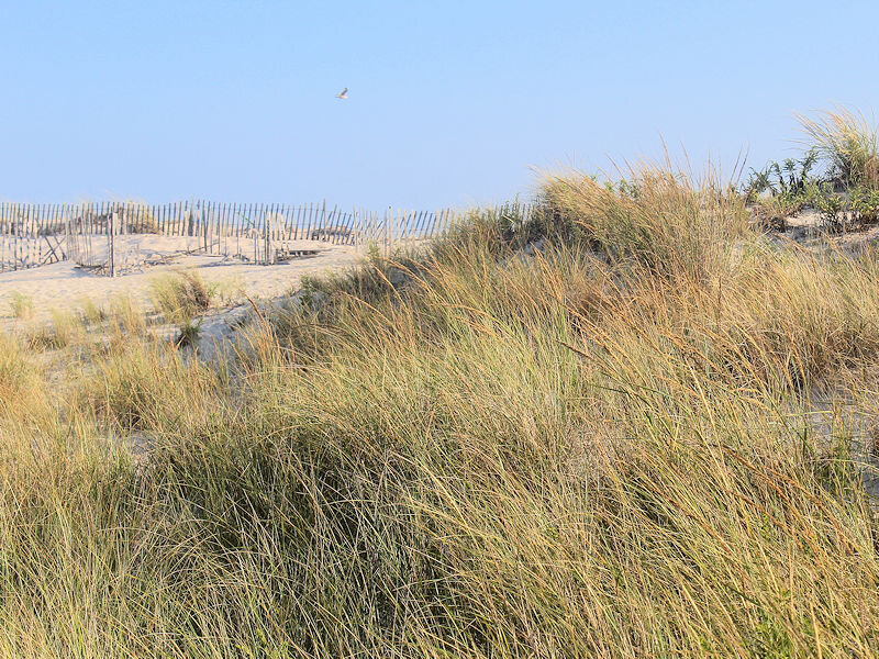
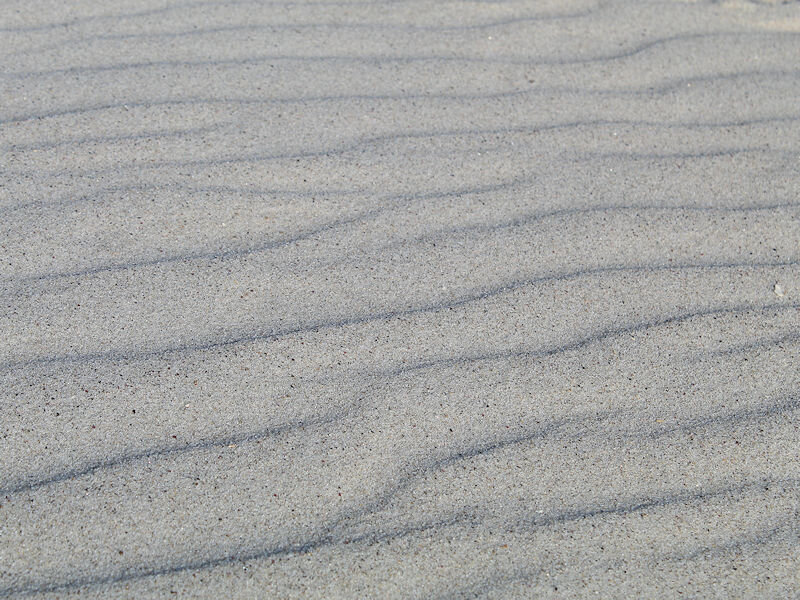
A brisk sea breeze, temperatures in the lower 80s, and abnormally warm ocean temperatures made for a great beach day. Some photos from Robert Moses State Park from this afternoon.
- 1,529 replies
-
- 8
-
-
- hurricane
- tropical storm
- (and 1 more)
-
Tomorrow will be a very warm day with temperatures reaching the middle and upper 80s across the region. A few of the hotter spots could hit 90°. Somewhat cooler air will arrive afterward and then a sharp cold shot is likely after midweek. In the longer range, there remains greater than usual uncertainty, as extratropical Merbok, which pounded the Bering Sea area, could impact the jet stream. Occasionally, such cyclones have set in motion a pattern evolution that has dislodged cold air that pours into the continental U.S. 1-2 weeks later. A classic example from the far more intense Nuri occurred in 2014. Nuri bombed out as it battered the Bering Sea region on November 9. Very cold air moved into the northeastern U.S. starting on November 15. Near record and even some record low temperatures occurred from November 18-22. Merbok will not reach Nuri's intensity, but the scenario of a strong cold shot to close out September and open October is plausible. In the 6 past cases when the June AO averaged +0.750 or above (1950-2021), 67% of the following August and September cases featured above normal temperatures. The August ECMWF forecast shows a warmer than normal September in the Northeast. This warmth would be consistent with the ongoing warming that has been occurring in September. On August 18, the SOI fell to -32.90. Since 1991, there were 8 cases when the SOI fell to -30 or below during the August 10-25 period. That outcome has often preceded a wetter than normal September in parts of the Northeast. Mean September rainfall figures for those 8 cases: Boston: 4.38" (normal: 3.55"); New York City: 5.08" (normal: 4.31"); and, Philadelphia: 5.12" (normal: 4.40"). Very wet years outnumbered very dry ones by a 2:1 ratio in Boston and 3:1 ratio in both New York City and Philadelphia. 63% of cases saw at least one day with 1" or more rainfall in Boston. 88% saw at least one day with 1" or more in New York City and Philadelphia. 50% of those cases saw at least one day with 2" or more daily rainfall in Philadelphia. In sum, the SOI may be offering a signal that there will be some drought relief for the northern Mid-Atlantic and southern New England regions in September. On September 7, Philadelphia picked up 1.22" of rain. The ENSO Region 1+2 anomaly was -0.9°C and the Region 3.4 anomaly was -1.0°C for the week centered around September 6. For the past six weeks, the ENSO Region 1+2 anomaly has averaged -0.62°C and the ENSO Region 3.4 anomaly has averaged -1.00°C. La Niña conditions will likely persist through the fall. The SOI was +31.91 today. That broke the daily record of +28.76, which was set in 2013. The preliminary Arctic Oscillation (AO) was -0.911 today. On September 16 the MJO was in Phase 8 at an amplitude of 0.220 (RMM). The September 15-adjusted amplitude was 0.482 (RMM). Based on sensitivity analysis applied to the latest guidance, there is an implied 76% probability that New York City will have a warmer than normal September (1991-2020 normal). September will likely finish with a mean temperature near 70.9° (1.7° above normal).
- 1,529 replies
-
- 1
-
-
- hurricane
- tropical storm
- (and 1 more)
-
Morning thoughts… Today will be mostly sunny and warm. High temperatures will reach the lower and middle 80s in most of the region. Likely high temperatures around the region include: New York City (Central Park): 85° Newark: 87° Philadelphia: 87° The warmth will peak tomorrow. Normals: New York City: 30-Year: 75.6°; 15-Year: 76.4° Newark: 30-Year: 77.0°; 15-Year: 78.0° Philadelphia: 30-Year: 78.2°; 15-Year: 79.1°
-
Noticeably warmer air will return tomorrow to close out the weekend and continue into early next week. The potential exists for parts of the region to experience 90° or above temperatures at the height of the warmth. Philadelphia and Newark have the best chance at approaching or reaching 90° during the peak of the warmth. New York City will likely top out in the middle or upper 80s. In the longer range, there is greater than usual uncertainty, as extratropical Merbok, which pounded the Bering Sea area, could impact the jet stream. Occasionally, such cyclones have set in motion a pattern evolution that has dislodged cold air that pours into the continental U.S. 1-2 weeks later. A classic example from the far more intense Nuri occurred in 2014. Nuri bombed out as it battered the Bering Sea region on November 9. Very cold air moved into the northeastern U.S. starting on November 15. Near record and even some record low temperatures occurred from November 18-22. Merbok will not reach Nuri's intensity, but the scenario of a strong cold shot to close out September and open October is plausible. In the 6 past cases when the June AO averaged +0.750 or above (1950-2021), 67% of the following August and September cases featured above normal temperatures. The August ECMWF forecast shows a warmer than normal September in the Northeast. This warmth would be consistent with the ongoing warming that has been occurring in September. On August 18, the SOI fell to -32.90. Since 1991, there were 8 cases when the SOI fell to -30 or below during the August 10-25 period. That outcome has often preceded a wetter than normal September in parts of the Northeast. Mean September rainfall figures for those 8 cases: Boston: 4.38" (normal: 3.55"); New York City: 5.08" (normal: 4.31"); and, Philadelphia: 5.12" (normal: 4.40"). Very wet years outnumbered very dry ones by a 2:1 ratio in Boston and 3:1 ratio in both New York City and Philadelphia. 63% of cases saw at least one day with 1" or more rainfall in Boston. 88% saw at least one day with 1" or more in New York City and Philadelphia. 50% of those cases saw at least one day with 2" or more daily rainfall in Philadelphia. In sum, the SOI may be offering a signal that there will be some drought relief for the northern Mid-Atlantic and southern New England regions in September. On September 7, Philadelphia picked up 1.22" of rain. The ENSO Region 1+2 anomaly was -0.9°C and the Region 3.4 anomaly was -1.0°C for the week centered around September 6. For the past six weeks, the ENSO Region 1+2 anomaly has averaged -0.62°C and the ENSO Region 3.4 anomaly has averaged -1.00°C. La Niña conditions will likely persist through the fall. The SOI was +29.42 today. That broke the daily record of +25.38, which was set in 2010. The preliminary Arctic Oscillation (AO) was -1.472 today. On September 15 the MJO was in Phase 8 at an amplitude of 0.483 (RMM). The September 14-adjusted amplitude was 0.447 (RMM). Based on sensitivity analysis applied to the latest guidance, there is an implied 78% probability that New York City will have a warmer than normal September (1991-2020 normal). September will likely finish with a mean temperature near 71.1° (1.9° above normal).
- 1,529 replies
-
- 1
-
-
- hurricane
- tropical storm
- (and 1 more)
-
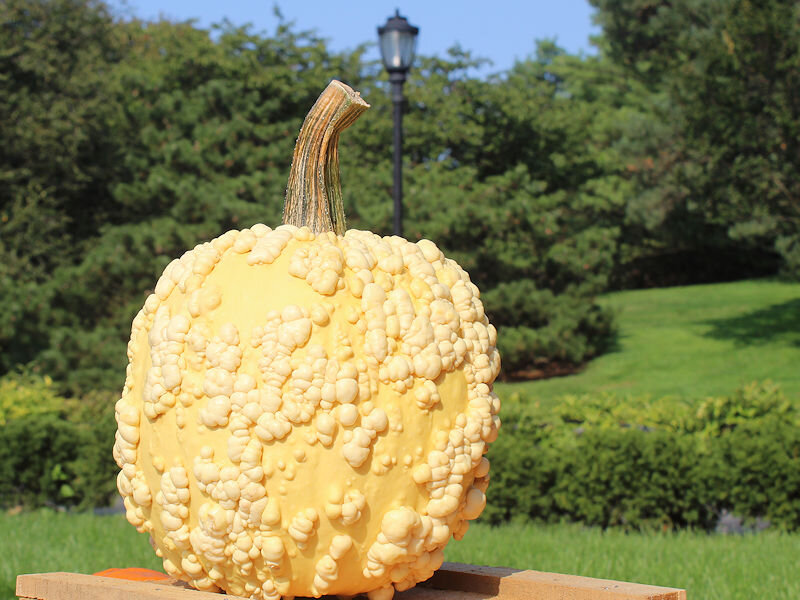
Under bright sunshine, the temperature soared to 75° in New York City. That made for a great opening day for the New York Botanical Garden's fall gourd show. Some photos:


- 1,529 replies
-
- 8
-
-
- hurricane
- tropical storm
- (and 1 more)
-
St. Paul Island recorded sustained winds of 55.2 mph yesterday. That was the highest figure since December 3, 2011 when 56 mph winds were recorded. It was the highest September figure since September 29, 1958 when sustained winds of 63 mph were measured.
- 1,529 replies
-
- 1
-
-
- hurricane
- tropical storm
- (and 1 more)
-
Morning thoughts… Today will be mostly sunny with near normal temperatures. High temperatures will reach the middle and upper 70s in most of the region. Some 80s are possible especially from central New Jersey southward. Likely high temperatures around the region include: New York City (Central Park): 76° Newark: 78° Philadelphia: 83° Much warmer air will arrive tomorrow. Normals: New York City: 30-Year: 75.9°; 15-Year: 76.7° Newark: 30-Year: 77.4°; 15-Year: 78.3° Philadelphia: 30-Year: 78.6°; 15-Year: 79.4°
-
Much of the region saw its coolest morning so far this season. Low temperatures included: Albany: 45° Allentown: 46° Binghamton: 41° Boston: 55° Bridgeport: 50° Danbury: 45° Islip: 50° New York City: 57° Newark: 53° Philadelphia: 58° Poughkeepsie: 43° Providence: 49° Scranton: 46° Westhampton: 40° White Plains: 49° The early autumnal chill will be short-lived. Noticeably warmer air will return to close out the weekend and continue into early next week. The potential exists for parts of the region to experience 90° or above temperatures at the height of the warmth. Philadelphia and Newark have the best chance at approaching or reaching 90° during the peak of the warmth. New York City will likely top out in the middle or upper 80s. In the longer range, there is greater than usual uncertainty, as extratropical Merbok, which will pound the Bering Sea and then Alaska's north shore through tomorrow, could impact the jet stream. Occasionally, such cyclones have set in motion a pattern evolution that has dislodged cold air that pours into the continental U.S. 1-2 weeks later. A classic example from the far more intense Nuri occurred in 2014. Nuri bombed out as it battered the Bering Sea region on November 9. Very cold air moved into the northeastern U.S. starting on November 15. Near record and even some record low temperatures occurred from November 18-22. Merbok will not reach Nuri's intensity, but the scenario of a strong cold shot to close out September and open October is plausible. In the 6 past cases when the June AO averaged +0.750 or above (1950-2021), 67% of the following August and September cases featured above normal temperatures. The August ECMWF forecast shows a warmer than normal September in the Northeast. This warmth would be consistent with the ongoing warming that has been occurring in September. On August 18, the SOI fell to -32.90. Since 1991, there were 8 cases when the SOI fell to -30 or below during the August 10-25 period. That outcome has often preceded a wetter than normal September in parts of the Northeast. Mean September rainfall figures for those 8 cases: Boston: 4.38" (normal: 3.55"); New York City: 5.08" (normal: 4.31"); and, Philadelphia: 5.12" (normal: 4.40"). Very wet years outnumbered very dry ones by a 2:1 ratio in Boston and 3:1 ratio in both New York City and Philadelphia. 63% of cases saw at least one day with 1" or more rainfall in Boston. 88% saw at least one day with 1" or more in New York City and Philadelphia. 50% of those cases saw at least one day with 2" or more daily rainfall in Philadelphia. In sum, the SOI may be offering a signal that there will be some drought relief for the northern Mid-Atlantic and southern New England regions in September. On September 7, Philadelphia picked up 1.22" of rain. The ENSO Region 1+2 anomaly was -0.9°C and the Region 3.4 anomaly was -1.0°C for the week centered around September 6. For the past six weeks, the ENSO Region 1+2 anomaly has averaged -0.62°C and the ENSO Region 3.4 anomaly has averaged -1.00°C. La Niña conditions will likely persist through the fall. The SOI was +20.68 today. The preliminary Arctic Oscillation (AO) was -1.666 today. On September 14 the MJO was in Phase 8 at an amplitude of 0.024 (RMM). The September 13-adjusted amplitude was 0.044 (RMM). Based on sensitivity analysis applied to the latest guidance, there is an implied 79% probability that New York City will have a warmer than normal September (1991-2020 normal). September will likely finish with a mean temperature near 71.2° (2.0° above normal).
- 1,529 replies
-
- 1
-
-
- hurricane
- tropical storm
- (and 1 more)
-
Morning thoughts… After a very cool start, today will be mostly sunny and cool. High temperatures will reach the middle and upper 70s in most of the region. Likely high temperatures around the region include: New York City (Central Park): 76° Newark: 79° Philadelphia: 80° Much warmer air will arrive on Sunday. Normals: New York City: 30-Year: 76.3°; 15-Year: 77.1° Newark: 30-Year: 77.8°; 15-Year: 78.6° Philadelphia: 30-Year: 79.0°; 15-Year: 79.7°
- 1,529 replies
-
- 1
-
-
- hurricane
- tropical storm
- (and 1 more)
-
The coolest air mass so far this season is continuing to overspread the region. The temperature will dip into the 50s for the first time this season at Central Park. Some outlying areas could see the mercury dip below 50°. However, the early autumnal chill will be short-lived. Noticeably warmer air will likely return early next week. The potential exists for parts of the region to experience 90° or above temperatures at the height of the warmth. Philadelphia and Newark have the best chance at approaching or reaching 90° during the peak of the warmth. New York City will likely top out in the middle or upper 80s. In the 6 past cases when the June AO averaged +0.750 or above (1950-2021), 67% of the following August and September cases featured above normal temperatures. The August ECMWF forecast shows a warmer than normal September in the Northeast. This warmth would be consistent with the ongoing warming that has been occurring in September. On August 18, the SOI fell to -32.90. Since 1991, there were 8 cases when the SOI fell to -30 or below during the August 10-25 period. That outcome has often preceded a wetter than normal September in parts of the Northeast. Mean September rainfall figures for those 8 cases: Boston: 4.38" (normal: 3.55"); New York City: 5.08" (normal: 4.31"); and, Philadelphia: 5.12" (normal: 4.40"). Very wet years outnumbered very dry ones by a 2:1 ratio in Boston and 3:1 ratio in both New York City and Philadelphia. 63% of cases saw at least one day with 1" or more rainfall in Boston. 88% saw at least one day with 1" or more in New York City and Philadelphia. 50% of those cases saw at least one day with 2" or more daily rainfall in Philadelphia. In sum, the SOI may be offering a signal that there will be some drought relief for the northern Mid-Atlantic and southern New England regions in September. On September 7, Philadelphia picked up 1.22" of rain. The ENSO Region 1+2 anomaly was -0.9°C and the Region 3.4 anomaly was -1.0°C for the week centered around September 6. For the past six weeks, the ENSO Region 1+2 anomaly has averaged -0.62°C and the ENSO Region 3.4 anomaly has averaged -1.00°C. La Niña conditions will likely persist through the fall. The SOI was +8.50 today. The preliminary Arctic Oscillation (AO) was -1.510 today. On September 13 the MJO was in Phase 2 at an amplitude of 0.030 (RMM). The September 12-adjusted amplitude was 0.229 (RMM). Based on sensitivity analysis applied to the latest guidance, there is an implied 80% probability that New York City will have a warmer than normal September (1991-2020 normal). September will likely finish with a mean temperature near 71.2° (2.0° above normal).
- 1,529 replies
-
- 1
-
-
- hurricane
- tropical storm
- (and 1 more)