

donsutherland1
-
Posts
24,176 -
Joined
Content Type
Profiles
Blogs
Forums
American Weather
Media Demo
Store
Gallery
Everything posted by donsutherland1
-
Morning thoughts… Today will be partly cloudy and a bit milder. High temperatures will reach the middle and upper 50s in most of the region. Likely high temperatures around the region include: New York City (Central Park): 58° Newark: 60° Philadelphia: 61° Tomorrow will be somewhat milder. Normals: New York City: 30-Year: 62.9°; 15-Year: 63.6° Newark: 30-Year: 64.4°; 15-Year: 65.4° Philadelphia: 30-Year: 65.6°; 15-Year: 66.1°
-
Today was another unseasonably cool day. The temperature was again confined to the 50s. Parts of the East saw record cold. Records included: Baton Rouge: 34° (old record: 36°, 1948) Charleston: 37° (old record: 39°, 1948) Jacksonville: 42° (old record: 43°, 1981 and 2009) Little Rock: 33° (tied record set in 1989) Savannah: 38° (old record: 40°, 2009) Tomorrow will be another chilly day following a frosty start in many suburban areas with temperatures peaking in the 50s. A few areas will reach or exceed 60°. Moderation is possible during the weekend. However, there will be a risk of precipitation. Afterward, with the MJO in Phase 6 at a high amplitude and the Arctic Oscillation forecast to go positive for the closing week of the month, the closing week of October could feature above normal temperatures. The ENSO Region 1+2 anomaly was -2.0°C and the Region 3.4 anomaly was -0.8°C for the week centered around October 12. For the past six weeks, the ENSO Region 1+2 anomaly has averaged -1.33°C and the ENSO Region 3.4 anomaly has averaged -0.87°C. La Niña conditions will likely persist through the fall. The SOI was +7.93 today. The preliminary Arctic Oscillation (AO) was -0.298 today. On October 17 the MJO was in Phase 6 at an amplitude of 1.404 (RMM). The October 16-adjusted amplitude was 1.456 (RMM). Based on sensitivity analysis applied to the latest guidance, there is an implied 65% probability that New York City will have a cooler than normal October (1991-2020 normal). October will likely finish with a mean temperature near 56.8° (1.3° below normal).
-
Morning thoughts… Today will be partly cloudy and unseasonably cool. High temperatures will reach the lower and middle 50s in most of the region. Likely high temperatures around the region include: New York City (Central Park): 54° Newark: 56° Philadelphia: 56° Tomorrow will be another cool day. Normals: New York City: 30-Year: 63.3°; 15-Year: 64.0° Newark: 30-Year: 64.8°; 15-Year: 65.8° Philadelphia: 30-Year: 66.0°; 15-Year: 66.6°
-
Despite partly sunny skies, readings were largely confined to the 50s in much of the region. Tomorrow will be another chilly day following a frosty start in many suburban areas with temperatures again peaking in the 50s. Moderation is possible during the weekend. There will be a risk of precipitation. Chicago could see the mercury reach 32° for the first time this season tomorrow morning. Last year, Chicago's first freeze occurred on November 2. The last freeze at least as early as the one that is forecast occurred on October 13, 2018. Afterward, with the MJO in Phase 6 at a high amplitude and the Arctic Oscillation forecast to go positive for the closing week of the month, the closing week of October could feature above normal temperatures. The ENSO Region 1+2 anomaly was -2.0°C and the Region 3.4 anomaly was -0.8°C for the week centered around October 12. For the past six weeks, the ENSO Region 1+2 anomaly has averaged -1.33°C and the ENSO Region 3.4 anomaly has averaged -0.87°C. La Niña conditions will likely persist through the fall. The SOI was +16.24 today. The preliminary Arctic Oscillation (AO) was -0.403 today. On October 16 the MJO was in Phase 6 at an amplitude of 1.452 (RMM). The October 15-adjusted amplitude was 1.686 (RMM). Based on sensitivity analysis applied to the latest guidance, there is an implied 69% probability that New York City will have a cooler than normal October (1991-2020 normal). October will likely finish with a mean temperature near 56.6° (1.5° below normal).
-
Morning thoughts… Today will be partly cloudy and unseasonably cool. High temperatures will reach the middle and upper 50s in most of the region. Likely high temperatures around the region include: New York City (Central Park): 56° Newark: 59° Philadelphia: 58° Tomorrow will be another very cool day. Normals: New York City: 30-Year: 63.6°; 15-Year: 64.4° Newark: 30-Year: 65.2°; 15-Year: 66.2° Philadelphia: 30-Year: 66.4°; 15-Year: 67.0°
-
A cold front is crossing the region. In its wake, much cooler air will cover the region through Friday. Tomorrow will be a chilly with readings rising only into the 50s. Moderation is possible during the weekend. There will be a risk of precipitation. Chicago could see the mercury reach 32° for the first time this season tomorrow or Wednesday morning. Last year, Chicago's first freeze occurred on November 2. The last freeze at least as early as the one that is forecast occurred on October 13, 2018. Afterward, with the MJO in Phase 6 at a high amplitude and the Arctic Oscillation forecast to go positive for the closing week of the month, the closing week of October could feature above normal temperatures. The ENSO Region 1+2 anomaly was -2.0°C and the Region 3.4 anomaly was -0.8°C for the week centered around October 12. For the past six weeks, the ENSO Region 1+2 anomaly has averaged -1.33°C and the ENSO Region 3.4 anomaly has averaged -0.87°C. La Niña conditions will likely persist through the fall. The SOI was +18.11 today. The preliminary Arctic Oscillation (AO) was -0.815 today. On October 15 the MJO was in Phase 6 at an amplitude of 1.684 (RMM). The October 14-adjusted amplitude was 2.050 (RMM). Based on sensitivity analysis applied to the latest guidance, there is an implied 68% probability that New York City will have a cooler than normal October (1991-2020 normal). October will likely finish with a mean temperature near 56.5° (1.4° below normal).
-
It was 95, which beat the prior record by 10 degrees.
-
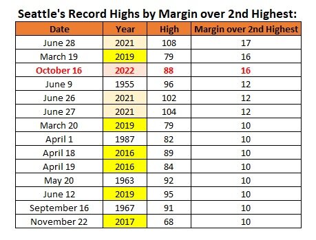
Seattle beat its daily record high temperature by 16°F (tied for the 2nd largest margin). There are 14 days on which the margin of record is 10°F or above, with a disproportionate share of such days occurring since 2015.
-
Morning thoughts… Today will be mostly cloudy and warm. There will be some showers, especially during the afternoon. High temperatures will reach the middle and upper 60s in most of the region. Likely high temperatures around the region include: New York City (Central Park): 65° Newark: 66° Philadelphia: 68° Much cooler air will move into the region by tomorrow. Normals: New York City: 30-Year: 64.0°; 15-Year: 64.8° Newark: 30-Year: 65.5°; 15-Year: 66.7° Philadelphia: 30-Year: 66.7°; 15-Year: 67.4°
-
Mountain West Discussion
donsutherland1 replied to mayjawintastawm's topic in Central/Western States
Portland, OR registered its third extreme October heat event this month. No previous October had more than one.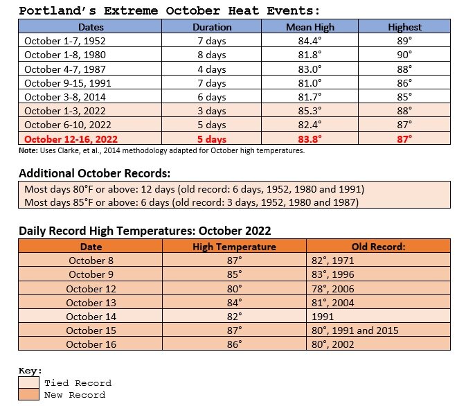
-
Mountain West Discussion
donsutherland1 replied to mayjawintastawm's topic in Central/Western States
Seattle reached an astonishing 88 degrees today, smashing is daily mark by 16 degrees and its second half of October record by 14 degrees. Bellingham, WA reached 80 degrees for the first time ever in October.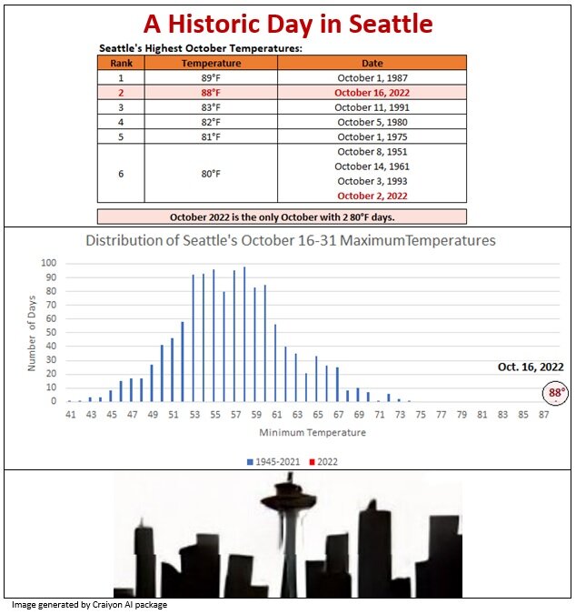
-
Under partly sunny skies, readings again climbed into the 60s across the region. Out West, it was another day of exceptional heat in the Pacific Northwest. Seattle recorded its highest temperature so late in the season and its second highest October reading on record. Only October 1, 1987 (89°) had a higher temperature. Bellingham, WA set an October monthly record. Its previous latest 80° temperature occurred on September 28, 2003 and again on September 28, 2017. Preliminary high temperatures included: Abbotsford, BC: 79° (old record: 76°, 2002) Bellingham, WA: 80° (old record: 71°, 2015 and 2018) ***New October Record*** Portland: 85° (old record: 80°, 2002) Seattle: 88° (old record: 72°, 2018) Vancouver: 68° (old record: 66°, 1997) Victoria: 75° (old record: 71°, 2002) Much cooler air will move into the region early this week. Tomorrow will be another mild day with temperatures rising into the 60s. A shower is possible tomorrow as a cold front cross the region. Behind the front, temperatures will rise no higher than the 50s through Thursday in many parts of the region. Moderation is possible during the weekend. Chicago will likely see the mercury reach 32° for the first time this season late tomorrow or Tuesday morning. Last year, Chicago's first freeze occurred on November 2. The last freeze at least as early as the one that is forecast occurred on October 13, 2018. Afterward, with the MJO in Phase 6 at a high amplitude and the Arctic Oscillation forecast to go positive for the closing week of the month, the closing week of October could feature above normal temperatures. The ENSO Region 1+2 anomaly was -1.6°C and the Region 3.4 anomaly was -0.8°C for the week centered around October 5. For the past six weeks, the ENSO Region 1+2 anomaly has averaged -1.07°C and the ENSO Region 3.4 anomaly has averaged -0.87°C. La Niña conditions will likely persist through the fall. The SOI was +24.30 today. The preliminary Arctic Oscillation (AO) was -0.978 today. On October 14 the MJO was in Phase 6 at an amplitude of 2.047 (RMM). The October 13-adjusted amplitude was 1.852 (RMM). Based on sensitivity analysis applied to the latest guidance, there is an implied 70% probability that New York City will have a cooler than normal October (1991-2020 normal). October will likely finish with a mean temperature near 56.3° (1.6° below normal).
-
Morning thoughts… Today will be partly sunny and warm. High temperatures will reach the upper 60s in most of the region. Likely high temperatures around the region include: New York City (Central Park): 67° Newark: 68° Philadelphia: 70° Much cooler air will move into the region by Tuesday. Normals: New York City: 30-Year: 64.4°; 15-Year: 65.2° Newark: 30-Year: 65.9°; 15-Year: 67.1° Philadelphia: 30-Year: 67.1°; 15-Year: 67.9°
-
Temperatures soared into the upper 60s and lower 70s today. The mild weather will continue through the weekend. However, much cooler air will likely move into the region early next week. Out West, the temperature smashed record highs in the Pacific Northwest. Records included: Astoria, OR: 83° (old record: 78°, 1954) *** latest 80° high on record*** Portland: 87° (old record: 80°, 1991 and 2015) Salem, OR: 92° (old record: 89°, 1901) ***latest 90° high on record*** Since 1950, 15/21 (71%) of cases with an ENSO Region 1+2 anomaly of -0.75°C or below were warmer than normal in the Middle Atlantic region, including Philadelphia and New York City. 48% were 1° or more above average in New York City and 62% were 1° or more above average in Philadelphia. Just 14% were 1° or more below normal in New York City while 24% were 1° or more below normal in Philadelphia. One-third of cases in both cities saw a monthly mean temperature of 60° or above. Overall, such ENSO conditions also favored warmth in the Central and Northern Plains, along with dry conditions in the Plains States. October 1988 was the coldest exception. The closing week of September saw the coldest Region 1+2 anomaly since September 1988. That development has increased the probability of a cooler outcome this month. A cooler than normal October is the base case. October 2022 is well on track for a colder than normal outcome. For example, 26/29 (89.7%) cases that saw October 1-10 wind up with a mean temperature of 56.5° or below in New York City, had a monthly mean temperature below the current normal average of 57.9°. The ENSO Region 1+2 anomaly was -1.6°C and the Region 3.4 anomaly was -0.8°C for the week centered around October 5. For the past six weeks, the ENSO Region 1+2 anomaly has averaged -1.07°C and the ENSO Region 3.4 anomaly has averaged -0.87°C. La Niña conditions will likely persist through the fall. The SOI was +24.62 today. The preliminary Arctic Oscillation (AO) was -0.086 today. On October 13 the MJO was in Phase 6 at an amplitude of 1.845 (RMM). The October 12-adjusted amplitude was 1.689 (RMM). Based on sensitivity analysis applied to the latest guidance, there is an implied 75% probability that New York City will have a cooler than normal October (1991-2020 normal). October will likely finish with a mean temperature near 56.1° (1.8° below normal).
-
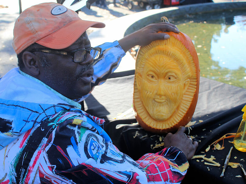
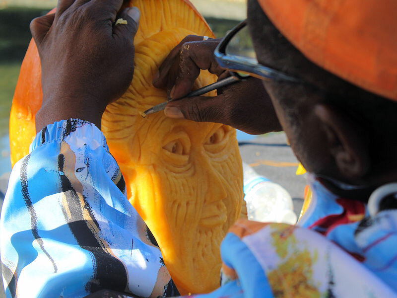
Under brilliant sunshine and temperatures in the upper 60s, the New York Botanical Garden held a pumpkin-carving contest between three internationally-recognized artists. Alan Silva Lincoln Bias Lenny Calvin The winner is announced The winning carving


-
Morning thoughts… Today will be mostly sunny and warm. High temperatures will reach the upper 60s and lower 70s in most of the region. Likely high temperatures around the region include: New York City (Central Park): 69° Newark: 72° Philadelphia: 74° Much cooler air will move into the region early next week. Normals: New York City: 30-Year: 64.7°; 15-Year: 65.6° Newark: 30-Year: 66.3°; 15-Year: 67.5° Philadelphia: 30-Year: 67.5°; 15-Year: 68.3°
-
The sun returned and today wound up becoming a mild autumn day. The mild weather will continue through the weekend. However, much cooler air will likely move into the region early next week. Out West, it was a tale of two seasons. At Portland, the temperature soared to 82°, which tied the daily mark set in 1991. It was also Portland's 10th 80° day this month, easily surpassing the old record of 6 days. At Minneapolis, a daily record 0.4" of snow fell. The last daily measurable snowfall prior to October 15th occurred on October 14, 2018 when 0.3" fell. Since 1950, 15/21 (71%) of cases with an ENSO Region 1+2 anomaly of -0.75°C or below were warmer than normal in the Middle Atlantic region, including Philadelphia and New York City. 48% were 1° or more above average in New York City and 62% were 1° or more above average in Philadelphia. Just 14% were 1° or more below normal in New York City while 24% were 1° or more below normal in Philadelphia. One-third of cases in both cities saw a monthly mean temperature of 60° or above. Overall, such ENSO conditions also favored warmth in the Central and Northern Plains, along with dry conditions in the Plains States. October 1988 was the coldest exception. The closing week of September saw the coldest Region 1+2 anomaly since September 1988. That development has increased the probability of a cooler outcome this month. A cooler than normal October is the base case. October 2022 is well on track for a colder than normal outcome. For example, 26/29 (89.7%) cases that saw October 1-10 wind up with a mean temperature of 56.5° or below in New York City, had a monthly mean temperature below the current normal average of 57.9°. The ENSO Region 1+2 anomaly was -1.6°C and the Region 3.4 anomaly was -0.8°C for the week centered around October 5. For the past six weeks, the ENSO Region 1+2 anomaly has averaged -1.07°C and the ENSO Region 3.4 anomaly has averaged -0.87°C. La Niña conditions will likely persist through the fall. The SOI was +23.46 today. The preliminary Arctic Oscillation (AO) was +0.533 today. On October 12 the MJO was in Phase 6 at an amplitude of 1.684 (RMM). The October 11-adjusted amplitude was 1.626 (RMM). Based on sensitivity analysis applied to the latest guidance, there is an implied 77% probability that New York City will have a cooler than normal October (1991-2020 normal). October will likely finish with a mean temperature near 56.0° (1.9° below normal).
-
From this distance, it’s difficult to make very reliable forecasts. It should be noted that some of the long-range seasonal models are not very cold right now.
-
Probably not, unless the PDO goes positive and there’s strong Atlantic blocking.
-
Morning thoughts… Today will be partly sunny and warm. High temperatures will reach the upper 60s and lower 70s in most of the region. Likely high temperatures around the region include: New York City (Central Park): 68° Newark: 69° Philadelphia: 71° Much cooler air will move into the region early next week. Normals: New York City: 30-Year: 65.1°; 15-Year: 66.0° Newark: 30-Year: 66.6°; 15-Year: 67.9° Philadelphia: 30-Year: 67.9°; 15-Year: 68.7°
-
After perhaps some early showers, sunshine will return tomorrow. It will remain mild. The mild weather will continue into the weekend. However, more cold air could begin to arrive late in the weekend or just afterward. Early next week could turn much cooler. Since 1950, 15/21 (71%) of cases with an ENSO Region 1+2 anomaly of -0.75°C or below were warmer than normal in the Middle Atlantic region, including Philadelphia and New York City. 48% were 1° or more above average in New York City and 62% were 1° or more above average in Philadelphia. Just 14% were 1° or more below normal in New York City while 24% were 1° or more below normal in Philadelphia. One-third of cases in both cities saw a monthly mean temperature of 60° or above. Overall, such ENSO conditions also favored warmth in the Central and Northern Plains, along with dry conditions in the Plains States. October 1988 was the coldest exception. The closing week of September saw the coldest Region 1+2 anomaly since September 1988. That development has increased the probability of a cooler outcome this month. A cooler than normal October is the base case. October 2022 is well on track for a colder than normal outcome. For example, 26/29 (89.7%) cases that saw October 1-10 wind up with a mean temperature of 56.5° or below in New York City, had a monthly mean temperature below the current normal average of 57.9°. The ENSO Region 1+2 anomaly was -1.6°C and the Region 3.4 anomaly was -0.8°C for the week centered around October 5. For the past six weeks, the ENSO Region 1+2 anomaly has averaged -1.07°C and the ENSO Region 3.4 anomaly has averaged -0.87°C. La Niña conditions will likely persist through the fall. The SOI was +22.11 today. The preliminary Arctic Oscillation (AO) was +0.968 today. On October 11 the MJO was in Phase 6 at an amplitude of 1.619 (RMM). The October 10-adjusted amplitude was 1.332 (RMM). Based on sensitivity analysis applied to the latest guidance, there is an implied 74% probability that New York City will have a cooler than normal October (1991-2020 normal). October will likely finish with a mean temperature near 56.0° (1.9° below normal).
-
Winter 2022-2023 outlook compiled by The Washington Post. The NOAA, Weather.com, and AccuWeather outlooks are in reasonable agreement, especially with temperatures. WeatherBell is the cold outlier. The article notes of WeatherBell: The winter outlook from WeatherBell Analytics, a weather consulting firm, should put more pep in the step of snow lovers. The firm predicts temperatures that are normal to slightly below normal for nearly all of the country from November 2022 to March 2023. https://www.washingtonpost.com/climate-environment/2022/10/13/winter-outlooks-united-states-snow/
-
Morning thoughts… Today will be mostly cloudy and mild. There will be some periods of rain and perhaps a thunderstorm. High temperatures will reach the upper 60s and lower 70s in most of the region. Likely high temperatures around the region include: New York City (Central Park): 67° Newark: 69° Philadelphia: 70° Much cooler air will move into the region early next week. Normals: New York City: 30-Year: 65.5°; 15-Year: 66.5° Newark: 30-Year: 67.0°; 15-Year: 68.3° Philadelphia: 30-Year: 68.3°; 15-Year: 69.2°
-
Tomorrow will be mostly cloudy with periods of rain. Some locations could experience a thunderstorm. It will be mild with temperatures rising into the middle and upper 60s. The mild weather will continue into the weekend. However, more cold air could begin to arrive late in the weekend. Early next week could turn much cooler. Out West, Portland reached 80° for the 8th time this month. The previous October record was 6 days. That record was set in 1952 and tied in 1980 and 1991. Since 1950, 15/21 (71%) of cases with an ENSO Region 1+2 anomaly of -0.75°C or below were warmer than normal in the Middle Atlantic region, including Philadelphia and New York City. 48% were 1° or more above average in New York City and 62% were 1° or more above average in Philadelphia. Just 14% were 1° or more below normal in New York City while 24% were 1° or more below normal in Philadelphia. One-third of cases in both cities saw a monthly mean temperature of 60° or above. Overall, such ENSO conditions also favored warmth in the Central and Northern Plains, along with dry conditions in the Plains States. October 1988 was the coldest exception. The closing week of September saw the coldest Region 1+2 anomaly since September 1988. That development has increased the probability of a cooler outcome this month. A cooler than normal October is the base case. October 2022 is well on track for a colder than normal outcome. For example, 26/29 (89.7%) cases that saw October 1-10 wind up with a mean temperature of 56.5° or below in New York City, had a monthly mean temperature below the current normal average of 57.9°. The ENSO Region 1+2 anomaly was -1.6°C and the Region 3.4 anomaly was -0.8°C for the week centered around October 5. For the past six weeks, the ENSO Region 1+2 anomaly has averaged -1.07°C and the ENSO Region 3.4 anomaly has averaged -0.87°C. La Niña conditions will likely persist through the fall. The SOI was +21.53 today. The preliminary Arctic Oscillation (AO) was +2.318 today. On October 10 the MJO was in Phase 6 at an amplitude of 1.330 (RMM). The October 9-adjusted amplitude was 1.143 (RMM). Based on sensitivity analysis applied to the latest guidance, there is an implied 74% probability that New York City will have a cooler than normal October (1991-2020 normal). October will likely finish with a mean temperature near 55.9° (2.0° below normal).
-
Morning thoughts… Today will be partly sunny and warm. High temperatures will reach the upper 60s and lower 70s in most of the region. Likely high temperatures around the region include: New York City (Central Park): 69° Newark: 71° Philadelphia: 72° Slightly cooler air will arrive to end the week. Normals: New York City: 30-Year: 65.8°; 15-Year: 66.9° Newark: 30-Year: 67.4°; 15-Year: 68.7° Philadelphia: 30-Year: 68.7°; 15-Year: 69.6°


