donsutherland1
-
Posts
24,169 -
Joined
Content Type
Profiles
Blogs
Forums
American Weather
Media Demo
Store
Gallery
Everything posted by donsutherland1
-
Mountain West Discussion
donsutherland1 replied to mayjawintastawm's topic in Central/Western States
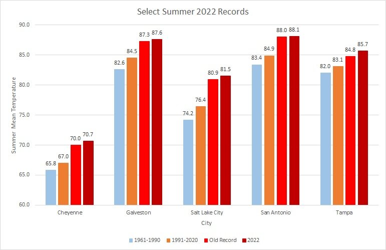
The unprecedented late-season heatwave that has scorched parts of the West has resulted in numerous locations seeing their hottest September 1-5 period on record. A sample of locations is below.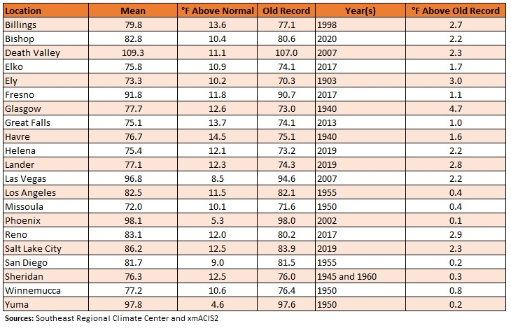
-
Clouds gradually pushed into the region this afternoon ahead of a slow-moving front. Showers and thunderstorms along that front will lead to a significant rainfall through early Wednesday. A general 1.00"-2.00" rainfall appears likely with locally higher amounts. Drought-stricken southern New England could see 1.50"-3.00" or rain with some locally much higher amounts. Already, a small part of Rhode Island has seen 3"-6" or rain. Ahead of the front, temperatures climbed well into the 80s. Highs included: Baltimore: 87° Bridgeport: 83° Islip: 85° New York City: 88° Newark: 87° Philadelphia: 90° Washington, DC: 87° The ongoing intense heatwave will continue into Wednesday (and Thursday at some locations) in the West. Today's preliminary high temperatures included: Casper: 97° Cheyenne: 95° (old record: 94°, 2020) ***Record 8th 95° or above day*** Death Valley, CA: 121° ***Record 5th 120° or above day in September*** Denver: 97° Fairfield (Travis Air Force Base), CA: 117° (old record: 96°, 1958) ***New all-time record*** Redding, CA: 113° Reno: 102° (old record: 100°, 2020) Sacramento: 114° (old record: 108°, 1988) ***New September record*** Salinas, CA: 103° (old record: 97°, 2004) Salt Lake City: 104° (old record: 100°, 2020) ***New September record for the 3rd time in 5 days*** San Francisco: 97° (old record: 94°, 2004) San Jose: 104° (old record: 99°, 2008) Santa Rosa, CA: 112° (old record: 101°, 1923 and 2008) ***New September record*** In the 6 past cases when the June AO averaged +0.750 or above (1950-2021), 67% of the following August and September cases featured above normal temperatures. The August ECMWF forecast shows a warmer than normal September in the Northeast. This warmth would be consistent with the ongoing warming that has been occurring in September. On August 18, the SOI fell to -32.90. Since 1991, there were 8 cases when the SOI fell to -30 or below during the August 10-25 period. That outcome has often preceded a wetter than normal September in parts of the Northeast. Mean September rainfall figures for those 8 cases: Boston: 4.38" (normal: 3.55"); New York City: 5.08" (normal: 4.31"); and, Philadelphia: 5.12" (normal: 4.40"). Very wet years outnumbered very dry ones by a 2:1 ratio in Boston and 3:1 ratio in both New York City and Philadelphia. 63% of cases saw at least one day with 1" or more rainfall in Boston. 88% saw at least one day with 1" or more in New York City and Philadelphia. 50% of those cases saw at least one day with 2" or more daily rainfall in Philadelphia. In sum, the SOI may be offering a signal that there will be some drought relief for the northern Mid-Atlantic and southern New England regions in September. The ENSO Region 1+2 anomaly was -0.4°C and the Region 3.4 anomaly was -0.8°C for the week centered around August 31. For the past six weeks, the ENSO Region 1+2 anomaly has averaged -0.62°C and the ENSO Region 3.4 anomaly has averaged -0.95°C. La Niña conditions will likely persist through the fall. The SOI was +19.26 today. The preliminary Arctic Oscillation (AO) was -0.792 today. On September 3 the MJO was in Phase 4 at an amplitude of 0.549 (RMM). The September 2-adjusted amplitude was 0.587 (RMM).
- 1,529 replies
-
- 1
-

-
- hurricane
- tropical storm
- (and 1 more)
-
Morning thoughts… It will be mostly cloudy and cooler. Rain and thunderstorms are likely, especially later today and tomorrow. A general 1.00”-2.00” of rain is likely with locally higher amounts. Southern New England will see a general 1.5”-3.00” rainfall with some higher amounts. High temperatures will reach the upper 70s and lower 80s in most of the region. Central New Jersey southward will see warmer temperatures. Likely high temperatures around the region include: New York City (Central Park): 81° Newark: 84° Philadelphia: 87° Somewhat cooler than normal conditions are likely through Thursday. Normals: New York City: 30-Year: 79.9°; 15-Year: 80.0° Newark: 30-Year: 81.3°; 15-Year: 81.5° Philadelphia: 30-Year: 82.5°; 15-Year: 82.4°
-
Under partly to mostly sunny skies, parts of the region saw temperatures surge into the lower 90s. High temperatures included: Baltimore: 91° New York City: 90° Newark: 92° Philadelphia: 91° Washington, DC: 91° A somewhat cooler than normal and wet period now lies ahead. That period will likely extend through Thursday. A significant rainfall is likely from tomorrow into Wednesday. A general 1.00"-2.00" rainfall appears likely with locally higher amounts. The ongoing intense heatwave will continue into Wednesday (and Thursday at some locations) in the West. Today's preliminary high temperatures included: Burbank, CA: 110° (tied record from 1984) ***Potential new all-time low of 83°*** Camarillo, CA: 106° (old record: 93°, 1961) ***tied September record*** Casper: 100° (old record: 96°, 1998) ***new September record*** Cheyenne: 94° (old record: 93°, 1960) Death Valley, CA: 124° (old record: 122°, 2020) ***Record 4th 120° or above temperature in September*** Great Falls: 94° (tied record set in 1998 and tied in 2001 and 2003) Lander, WY: 99° (old record: 94°, 1995 and 2019) ***new September record*** Long Beach, CA: 109° (old record: 107°, 1988) Pocatello, ID: 97° (old record: 96°, 1998) Reno: 104° (old record: 102°, 2020) ***new September record*** Salt Lake City: 102° (old record: 98°, 1950, 2017 and 2019) Sheridan, WY: 102° Casper's previous latest 100° temperature was August 12, 2018. In the 6 past cases when the June AO averaged +0.750 or above (1950-2021), 67% of the following August and September cases featured above normal temperatures. The August ECMWF forecast shows a warmer than normal September in the Northeast. This warmth would be consistent with the ongoing warming that has been occurring in September. On August 18, the SOI fell to -32.90. Since 1991, there were 8 cases when the SOI fell to -30 or below during the August 10-25 period. That outcome has often preceded a wetter than normal September in parts of the Northeast. Mean September rainfall figures for those 8 cases: Boston: 4.38" (normal: 3.55"); New York City: 5.08" (normal: 4.31"); and, Philadelphia: 5.12" (normal: 4.40"). Very wet years outnumbered very dry ones by a 2:1 ratio in Boston and 3:1 ratio in both New York City and Philadelphia. 63% of cases saw at least one day with 1" or more rainfall in Boston. 88% saw at least one day with 1" or more in New York City and Philadelphia. 50% of those cases saw at least one day with 2" or more daily rainfall in Philadelphia. In sum, the SOI may be offering a signal that there will be some drought relief for the northern Mid-Atlantic and southern New England regions in September. The ENSO Region 1+2 anomaly was -0.5°C and the Region 3.4 anomaly was -0.9°C for the week centered around August 24. For the past six weeks, the ENSO Region 1+2 anomaly has averaged -0.72°C and the ENSO Region 3.4 anomaly has averaged -0.93°C. La Niña conditions will likely persist through the fall. The SOI was +16.28 today. The preliminary Arctic Oscillation (AO) was -1.186 today. On September 2 the MJO was in Phase 3 at an amplitude of 0.586 (RMM). The September 1-adjusted amplitude was 0.709 (RMM).
- 1,529 replies
-
- 1
-
-
- hurricane
- tropical storm
- (and 1 more)
-
Morning thoughts… It will be increasingly cloudy and warm. High temperatures will reach the middle and perhaps upper 80s in most of the region. Likely high temperatures around the region include: New York City (Central Park): 85° Newark: 87° Philadelphia: 88° A significant rainfall is likely from later tomorrow into Wednesday. Somewhat cooler than normal conditions are likely through Thursday.. Normals: New York City: 30-Year: 80.1°; 15-Year: 80.2° Newark: 30-Year: 81.6°; 15-Year: 81.7° Philadelphia: 30-Year: 82.7°; 15-Year: 82.6°
-
Under bright sunshine, temperatures returned to the lower 80s this afternoon. Tomorrow will be warmer with highs in the middle and upper 80s. A moderate to significant rainfall is likely from late Monday into Wednesday. A general 0.50"-1.50" rainfall appears likely. Some higher amounts will likely fall north and west of Newark and New York City. The ongoing intense heatwave will continue into early next week in the West. Today's preliminary high temperatures included: Belgrade, MT: 100° (96°, 2007) ***tied September record*** Billings: 101° (old record: 97°, 1950 and 1978) Boise: 102° (old record: 101°, 1931 and 2007) ***tied September record*** Cut Bank: 96° (old record: 94°, 1950) Death Valley: 122° (tied record set in 2007) Dillon, MT: 97° (old record: 95°, 2017) ***new September record*** Glasgow, MT: 100° Great Falls, MT: 102° (old record: 95°, 1978) ***new September record*** Havre, MT: 103° (old record: 99°, 2009) ***new September record*** Helena, MT: 99° (old record: 97°, 2017) ***tied September record*** Lancaster, CA: 109° (old record: 108°, 1955) Lewistown, MT: 97° (old record: 93°, 2001) Reno: 100° Salt Lake City: 103° (old record: 98°, 2017) ***new September record*** Sheridan, WY: 101° (old record: 99°, 1950) In the 6 past cases when the June AO averaged +0.750 or above (1950-2021), 67% of the following August and September cases featured above normal temperatures. The August ECMWF forecast shows a warmer than normal September in the Northeast. This warmth would be consistent with the ongoing warming that has been occurring in September. On August 18, the SOI fell to -32.90. Since 1991, there were 8 cases when the SOI fell to -30 or below during the August 10-25 period. That outcome has often preceded a wetter than normal September in parts of the Northeast. Mean September rainfall figures for those 8 cases: Boston: 4.38" (normal: 3.55"); New York City: 5.08" (normal: 4.31"); and, Philadelphia: 5.12" (normal: 4.40"). Very wet years outnumbered very dry ones by a 2:1 ratio in Boston and 3:1 ratio in both New York City and Philadelphia. 63% of cases saw at least one day with 1" or more rainfall in Boston. 88% saw at least one day with 1" or more in New York City and Philadelphia. 50% of those cases saw at least one day with 2" or more daily rainfall in Philadelphia. In sum, the SOI may be offering a signal that there will be some drought relief for the northern Mid-Atlantic and southern New England regions in September. The recent passage of the MJO through Phase 2 at a very high amplitude (1.500 or above) during late August has introduced greater uncertainty. The ENSO Region 1+2 anomaly was -0.5°C and the Region 3.4 anomaly was -0.9°C for the week centered around August 24. For the past six weeks, the ENSO Region 1+2 anomaly has averaged -0.72°C and the ENSO Region 3.4 anomaly has averaged -0.93°C. La Niña conditions will likely persist through the fall. The SOI was +16.46 today. The preliminary Arctic Oscillation (AO) was -1.791 today. On September 1 the MJO was in Phase 3 at an amplitude of 0.711 (RMM). The August 31-adjusted amplitude was 0.932 (RMM).
-
Morning thoughts… It will be mostly sunny and somewhat warmer. High temperatures will reach the lower and perhaps middle 80s in most of the region. Likely high temperatures around the region include: New York City (Central Park): 80° Newark: 82° Philadelphia: 88° Generally warmer than normal conditions will persist through the weekend. A moderate to significant rainfall is possible next week. Normals: New York City: 30-Year: 80.4°; 15-Year: 80.4° Newark: 30-Year: 81.8°; 15-Year: 81.9° Philadelphia: 30-Year: 83.0°; 15-Year: 82.8°
- 1,529 replies
-
- 1
-
-
- hurricane
- tropical storm
- (and 1 more)
-
Tomorrow will be fair with near seasonable temperatures. The weekend will end with warmer readings. A moderate to significant rainfall is possible from late Monday into Wednesday. The ongoing intense heatwave will continue into early next week in the West. Today's preliminary high temperatures included: Bishop, CA: 107° (old record: 106°, 1950) Boise: 101° (tied record set in 1950) Burns, OR: 102° (old record: 100°, 1950) Death Valley, CA: 124° (old record: 123°, 1996) Lancaster, CA: 113° (old record: 112°, 1950) ***New September record*** Reno: 102° (old record: 101°, 1950) ***Tied September record*** Salt Lake City: 100° (old record: 98°, 1947 and 2019) In addition, Lytton, BC reached 103° (39.6°C). That set a new September record high for British Columbia. In the 6 past cases when the June AO averaged +0.750 or above (1950-2021), 67% of the following August and September cases featured above normal temperatures. The August ECMWF forecast shows a warmer than normal September in the Northeast. This warmth would be consistent with the ongoing warming that has been occurring in September. On August 18, the SOI fell to -32.90. Since 1991, there were 8 cases when the SOI fell to -30 or below during the August 10-25 period. That outcome has often preceded a wetter than normal September in parts of the Northeast. Mean September rainfall figures for those 8 cases: Boston: 4.38" (normal: 3.55"); New York City: 5.08" (normal: 4.31"); and, Philadelphia: 5.12" (normal: 4.40"). Very wet years outnumbered very dry ones by a 2:1 ratio in Boston and 3:1 ratio in both New York City and Philadelphia. 63% of cases saw at least one day with 1" or more rainfall in Boston. 88% saw at least one day with 1" or more in New York City and Philadelphia. 50% of those cases saw at least one day with 2" or more daily rainfall in Philadelphia. In sum, the SOI may be offering a signal that there will be some drought relief for the northern Mid-Atlantic and southern New England regions in September. The recent passage of the MJO through Phase 2 at a very high amplitude (1.500 or above) during late August has introduced greater uncertainty. The ENSO Region 1+2 anomaly was -0.5°C and the Region 3.4 anomaly was -0.9°C for the week centered around August 24. For the past six weeks, the ENSO Region 1+2 anomaly has averaged -0.72°C and the ENSO Region 3.4 anomaly has averaged -0.93°C. La Niña conditions will likely persist through the fall. The SOI was +15.63 today. The preliminary Arctic Oscillation (AO) was -1.975 today. On August 31 the MJO was in Phase 2 at an amplitude of 0.938 (RMM). The August 30-adjusted amplitude was 1.066 (RMM).
- 1,529 replies
-
- 1
-
-
- hurricane
- tropical storm
- (and 1 more)
-
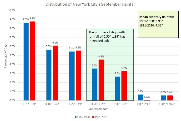
New York City's average monthly rainfall for September has increased from 3.95" to 4.31". A dramatic increase in the frequency of days with 0.50"-1.99" has driven this increase. The 1992-2021 average has risen to 4.52" skewed by Ida's 2021 rainfall.
-
Morning thoughts… It will be partly sunny and cooler. High temperatures will reach the upper 70s and lower 80s in most of the region. Likely high temperatures around the region include: New York City (Central Park): 85° Newark: 88° Philadelphia: 88° Generally warmer than normal conditions will persist through the weekend. A moderate to significant rainfall is possible next week. Normals: New York City: 30-Year: 80.7°; 15-Year: 80.6° Newark: 30-Year: 82.1°; 15-Year: 82.1° Philadelphia: 30-Year: 83.2°; 15-Year: 83.0°
- 1,529 replies
-
- 3
-
-
- hurricane
- tropical storm
- (and 1 more)
-
SLC already has 28 100-degree days this year. That has demolished the previous record of 21 days (1960, 1994, and 2021). It also had its hottest summer on record.
- 1,529 replies
-
- 1
-
-
- hurricane
- tropical storm
- (and 1 more)
-
Tomorrow will be cooler, but readings will still be near seasonable levels. In general, above normal temperatures will likely continue through at least much of the first week of September. An intense heatwave will continue into early next week in the West. Already, Salt Lake City set a September record high temperature of 101° today. The old daily record was 100° from 2019. 100° was also the old monthly record. High temperatures included: Death Valley, CA: 124° (old record: 121°, 1948 and 1996) Lancaster, CA: (old record: 110°, 1948 and 1950) Needles, CA: 112° Palm Springs, CA: 110° Salt Lake City: 101° (old record: 100°, 2019) ***new September record*** Boise and Salt Lake City could see temperatures approach or reach September records. Death Valley will likely see multiple 120° or hotter days. In the 6 past cases when the June AO averaged +0.750 or above (1950-2021), 67% of the following August and September cases featured above normal temperatures. The August ECMWF forecast shows a warmer than normal September in the Northeast. This warmth would be consistent with the ongoing warming that has been occurring in September. On August 18, the SOI fell to -32.90. Since 1991, there were 8 cases when the SOI fell to -30 or below during the August 10-25 period. That outcome has often preceded a wetter than normal September in parts of the Northeast. Mean September rainfall figures for those 8 cases: Boston: 4.38" (normal: 3.55"); New York City: 5.08" (normal: 4.31"); and, Philadelphia: 5.12" (normal: 4.40"). Very wet years outnumbered very dry ones by a 2:1 ratio in Boston and 3:1 ratio in both New York City and Philadelphia. 63% of cases saw at least one day with 1" or more rainfall in Boston. 88% saw at least one day with 1" or more in New York City and Philadelphia. 50% of those cases saw at least one day with 2" or more daily rainfall in Philadelphia. In sum, the SOI may be offering a signal that there will be some drought relief for the northern Mid-Atlantic and southern New England regions in September. The recent passage of the MJO through Phase 2 at a very high amplitude (1.500 or above) during late August has introduced greater uncertainty. The ENSO Region 1+2 anomaly was -0.5°C and the Region 3.4 anomaly was -0.9°C for the week centered around August 24. For the past six weeks, the ENSO Region 1+2 anomaly has averaged -0.72°C and the ENSO Region 3.4 anomaly has averaged -0.93°C. La Niña conditions will likely persist through the fall. The SOI was +26.09 today. The preliminary Arctic Oscillation (AO) was -1.525 today. On August 30 the MJO was in Phase 2 at an amplitude of 1.069 (RMM). The August 29-adjusted amplitude was 1.392 (RMM).
- 1,529 replies
-
- 2
-

-
- hurricane
- tropical storm
- (and 1 more)
-
Morning thoughts… It will be partly sunny and warm. High temperatures will reach the upper 80s and lower 90s in most of the region. Likely high temperatures around the region include: New York City (Central Park): 85° Newark: 88° Philadelphia: 88° Generally warmer than normal conditions will persist through at least much of the first week of September. Normals: New York City: 30-Year: 80.9°; 15-Year: 80.8° Newark: 30-Year: 82.3°; 15-Year: 82.3° Philadelphia: 30-Year: 83.5°; 15-Year: 83.2°
- 1,529 replies
-
- 1
-
-
- hurricane
- tropical storm
- (and 1 more)
-
New York City had a mean temperature of 79.4° in August, which was 3.3° above normal. Newark finished summer 2022 with a mean temperature of 79.2° (but was a few hundredths of a degree below the 1993 record). Above normal temperatures will likely continue through at least much of the first week of September. An intense heatwave that will continue into early September is under way in parts of the western U.S. and Canada. High temperatures today included: Boise: 106° (old record: 102°, 2004) ***latest 106° on record*** Burbank: 112° (old record: 108°, 2017) ***new all-time record*** Death Valley, CA: 123° Denver: 94° Salt Lake City: 102° (old record: 98°, 1950) Woodland Hills, CA: 112° (old record: 111°, 1998) Boise and Salt Lake City could see temperatures approach or reach September records. Death Valley will likely see multiple 120° or hotter days. In the 6 past cases when the June AO averaged +0.750 or above (1950-2021), 67% of the following August and September cases featured above normal temperatures. The August ECMWF forecast shows a warmer than normal September in the Northeast. This warmth would be consistent with the ongoing warming that has been occurring in September. On August 18, the SOI fell to -32.90. Since 1991, there were 8 cases when the SOI fell to -30 or below during the August 10-25 period. That outcome has often preceded a wetter than normal September in parts of the Northeast. Mean September rainfall figures for those 8 cases: Boston: 4.38" (normal: 3.55"); New York City: 5.08" (normal: 4.31"); and, Philadelphia: 5.12" (normal: 4.40"). Very wet years outnumbered very dry ones by a 2:1 ratio in Boston and 3:1 ratio in both New York City and Philadelphia. 63% of cases saw at least one day with 1" or more rainfall in Boston. 88% saw at least one day with 1" or more in New York City and Philadelphia. 50% of those cases saw at least one day with 2" or more daily rainfall in Philadelphia. In sum, the SOI may be offering a signal that there will be some drought relief for the northern Mid-Atlantic and southern New England regions in September. The recent passage of the MJO through Phase 2 at a very high amplitude (1.500 or above) during late August has introduced greater uncertainty. The ENSO Region 1+2 anomaly was -0.5°C and the Region 3.4 anomaly was -0.9°C for the week centered around August 24. For the past six weeks, the ENSO Region 1+2 anomaly has averaged -0.72°C and the ENSO Region 3.4 anomaly has averaged -0.93°C. La Niña conditions will likely persist through the fall. The SOI was +18.88 today. The preliminary Arctic Oscillation (AO) was -1.471 today. On August 29 the MJO was in Phase 2 at an amplitude of 1.865 (RMM). The August 28-adjusted amplitude was 1.930 (RMM).
-
Hottest Weather So Far Lies Ahead for Phoenix
donsutherland1 replied to donsutherland1's topic in Central/Western States
Phoenix is concluding its 6th hottest summer (tied with 1981, 2002, and 2011. Five of the last 10 summers have ranked in the top 10 in terms of heat.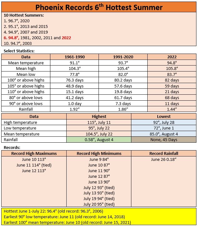
-
DCA _ NYC _ BOS __ ORD _ ATL _ IAH ___ DEN _ PHX _ SEA 1.1 1.5 2.0 1.2 1.2 0.2 1.3 2.0 1.8
-
Seattle's Record Heatwave
donsutherland1 replied to donsutherland1's topic in Central/Western States
Today Seattle reached 90°, which set a new record high for today. It was also the 12th such temperature this year, which tied the record for most such days from 2015. -
A very warm August is concluding. Tomorrow will again see above normal temperatures. Newark is on track to record its second warmest summer on record. There is some chance it could see its warmest summer on record. Philadelphia will see either its second or third warmest summer on record. Above normal temperatures will likely continue through at least much of the first week of September. An intense heatwave that will continue into early September is now evolving in parts of the western U.S. and Canada. Portland reached 99°, which surpassed the record of 98° that was set in 1987. Salt Lake City reached 101°, which surpassed the old record set in 1954. Seattle reached 90° breaking the record of 88° from 1987. It was also Seattle's 12th 90° day of the year, which tied the record for most such days from 2015. Boise and Salt Lake City could see temperatures approach or reach September records. Death Valley will likely see multiple 120° or hotter days. The ECMWF seasonal forecast indicates that the summer will be warmer than normal throughout the region and across much of North America. Based on how the pattern has been evolving during the spring transition to summer, it is more likely than not that the warmest anomalies of the summer will likely occur in July and August with June being the coolest of the three months in the Northeast. In addition, in the 6 past cases when the June AO averaged +0.750 or above (1950-2021), 67% of the following August and September cases featured above normal temperatures. The August ECMWF forecast shows a warmer than normal September in the Northeast. This warmth would be consistent with the ongoing warming that has been occurring in September. On August 18, the SOI fell to -32.90. Since 1991, there were 8 cases when the SOI fell to -30 or below during the August 10-25 period. That outcome has often preceded a wetter than normal September in parts of the Northeast. Mean September rainfall figures for those 8 cases: Boston: 4.38" (normal: 3.55"); New York City: 5.08" (normal: 4.31"); and, Philadelphia: 5.12" (normal: 4.40"). Very wet years outnumbered very dry ones by a 2:1 ratio in Boston and 3:1 ratio in both New York City and Philadelphia. 63% of cases saw at least one day with 1" or more rainfall in Boston. 88% saw at least one day with 1" or more in New York City and Philadelphia. 50% of those cases saw at least one day with 2" or more daily rainfall in Philadelphia. In sum, the SOI may be offering a signal that there will be some drought relief for the northern Mid-Atlantic and southern New England regions in September. The recent passage of the MJO through Phase 2 at a very high amplitude (1.500 or above) during late August has introduced greater uncertainty. The ENSO Region 1+2 anomaly was -0.5°C and the Region 3.4 anomaly was -0.9°C for the week centered around August 24. For the past six weeks, the ENSO Region 1+2 anomaly has averaged -0.72°C and the ENSO Region 3.4 anomaly has averaged -0.93°C. La Niña conditions will likely persist through the fall. The SOI was +18.88 today. The preliminary Arctic Oscillation (AO) was -1.563 today. On August 28 the MJO was in Phase 2 at an amplitude of 1.865 (RMM). The August 27-adjusted amplitude was 1.930 (RMM). Based on sensitivity analysis applied to the latest guidance, there is an implied near 100% probability that New York City will have a warmer than normal August (1991-2020 normal). August will likely finish with a mean temperature near 79.4° (3.3° above normal).
-
Morning thoughts… It will be partly sunny and vey warm. High temperatures will reach the upper 80s and lower 90s in most of the region. Likely high temperatures around the region include: New York City (Central Park): 88° Newark: 91° Philadelphia: 92° Generally warmer than normal conditions will persist through at least much of the first week of September. Normals: New York City: 30-Year: 81.3°; 15-Year: 81.2° Newark: 30-Year: 82.7°; 15-Year: 82.7° Philadelphia: 30-Year: 83.9°; 15-Year: 83.6°
-
Tomorrow will be a hot day. Temperatures will rise into the upper 80s and lower 90s. Newark is on track to record its second warmest summer on record. There is some chance it could see its warmest summer on record. Philadelphia will see either its second or third warmest summer on record. The remainder of August will likely see generally above normal temperatures. Additional 90° or above days are possible in parts of the region. Above normal temperatures will likely continue through at least much of the first week of September. Late August and early September will see an intense heatwave develop in parts of the western U.S. and Canada. Boise and Salt Lake City could see temperatures approach or reach September records. The ECMWF seasonal forecast indicates that the summer will be warmer than normal throughout the region and across much of North America. Based on how the pattern has been evolving during the spring transition to summer, it is more likely than not that the warmest anomalies of the summer will likely occur in July and August with June being the coolest of the three months in the Northeast. In addition, in the 6 past cases when the June AO averaged +0.750 or above (1950-2021), 67% of the following August and September cases featured above normal temperatures. The August ECMWF forecast shows a warmer than normal September in the Northeast. This warmth would be consistent with the ongoing warming that has been occurring in September. On August 18, the SOI fell to -32.90. Since 1991, there were 8 cases when the SOI fell to -30 or below during the August 10-25 period. That outcome has often preceded a wetter than normal September in parts of the Northeast. Mean September rainfall figures for those 8 cases: Boston: 4.38" (normal: 3.55"); New York City: 5.08" (normal: 4.31"); and, Philadelphia: 5.12" (normal: 4.40"). Very wet years outnumbered very dry ones by a 2:1 ratio in Boston and 3:1 ratio in both New York City and Philadelphia. 63% of cases saw at least one day with 1" or more rainfall in Boston. 88% saw at least one day with 1" or more in New York City and Philadelphia. 50% of those cases saw at least one day with 2" or more daily rainfall in Philadelphia. In sum, the SOI may be offering a signal that there will be some drought relief for the northern Mid-Atlantic and southern New England regions in September. The recent passage of the MJO through Phase 2 at a very high amplitude (1.500 or above) during late August has introduced greater uncertainty. The ENSO Region 1+2 anomaly was -0.5°C and the Region 3.4 anomaly was -0.9°C for the week centered around August 24. For the past six weeks, the ENSO Region 1+2 anomaly has averaged -0.72°C and the ENSO Region 3.4 anomaly has averaged -0.93°C. La Niña conditions will likely persist through the fall. The SOI was +19.36 today. The preliminary Arctic Oscillation (AO) was -1.379 today. On August 27 the MJO was in Phase 2 at an amplitude of 1.930 (RMM). The August 26-adjusted amplitude was 1.898 (RMM). Based on sensitivity analysis applied to the latest guidance, there is an implied near 100% probability that New York City will have a warmer than normal August (1991-2020 normal). August will likely finish with a mean temperature near 79.4° (3.3° above normal).
-
Morning thoughts… It will be mostly sunny and vey warm. High temperatures will reach the upper 80s and lower 90s in most of the region. Likely high temperatures around the region include: New York City (Central Park): 87° Newark: 90° Philadelphia: 93° Generally warmer than normal conditions will persist through at least much of the first week of September. Normals: New York City: 30-Year: 81.5°; 15-Year: 81.3° Newark: 30-Year: 82.9°; 15-Year: 82.9° Philadelphia: 30-Year: 84.1°; 15-Year: 83.8°
-
Clouds held temperatures to the low 80s from Newark to New York City. Farther south, Philadelphia topped out at 91°. Temperatures will rebound tomorrow. Newark is on track to record its second warmest summer on record. There is some chance it could see its warmest summer on record. Philadelphia will see either its second or third warmest summer on record. The remainder of August will likely see generally above normal temperatures. Additional 90° or above days are possible in parts of the region. Above normal temperatures will likely continue through at least much of the first week of September. The ECMWF seasonal forecast indicates that the summer will be warmer than normal throughout the region and across much of North America. Based on how the pattern has been evolving during the spring transition to summer, it is more likely than not that the warmest anomalies of the summer will likely occur in July and August with June being the coolest of the three months in the Northeast. In addition, in the 6 past cases when the June AO averaged +0.750 or above (1950-2021), 67% of the following August and September cases featured above normal temperatures. The August ECMWF forecast shows a warmer than normal September in the Northeast. This warmth would be consistent with the ongoing warming that has been occurring in September. On August 18, the SOI fell to -32.90. Since 1991, there were 8 cases when the SOI fell to -30 or below during the August 10-25 period. That outcome has often preceded a wetter than normal September in parts of the Northeast. Mean September rainfall figures for those 8 cases: Boston: 4.38" (normal: 3.55"); New York City: 5.08" (normal: 4.31"); and, Philadelphia: 5.12" (normal: 4.40"). Very wet years outnumbered very dry ones by a 2:1 ratio in Boston and 3:1 ratio in both New York City and Philadelphia. 63% of cases saw at least one day with 1" or more rainfall in Boston. 88% saw at least one day with 1" or more in New York City and Philadelphia. 50% of those cases saw at least one day with 2" or more daily rainfall in Philadelphia. In sum, the SOI may be offering a signal that there will be some drought relief for the northern Mid-Atlantic and southern New England regions in September. The recent passage of the MJO through Phase 2 at a very high amplitude (1.500 or above) during late August has introduced greater uncertainty. The ENSO Region 1+2 anomaly was -0.8°C and the Region 3.4 anomaly was -1.2°C for the week centered around August 10. For the past six weeks, the ENSO Region 1+2 anomaly has averaged -0.83°C and the ENSO Region 3.4 anomaly has averaged -0.88°C. La Niña conditions will likely persist through the fall. The SOI was +16.20 today. The preliminary Arctic Oscillation (AO) was -0.882 today. On August 26 the MJO was in Phase 2 at an amplitude of 1.898 (RMM). The August 25-adjusted amplitude was 1.768 (RMM). Based on sensitivity analysis applied to the latest guidance, there is an implied near 100% probability that New York City will have a warmer than normal August (1991-2020 normal). August will likely finish with a mean temperature near 79.3° (3.2° above normal).
-
Morning thoughts… Clouds will give way to partly sunny conditions. High temperatures will reach the lower and middle 80s in most of the region. Likely high temperatures around the region include: New York City (Central Park): 82° Newark: 85° Philadelphia: 89° Generally warmer than normal conditions will persist through at least much of the first week of September. Normals: New York City: 30-Year: 81.7°; 15-Year: 81.3° Newark: 30-Year: 82.9°; 15-Year: 82.9° Philadelphia: 30-Year: 84.1°; 15-Year: 83.8°
-
Today saw temperatures again reach the upper 80s and lower 90s in much of the region. High temperatures included: Allentown: 87° Baltimore: 90° Bridgeport: 86° Islip: 90° New York City: 90° Newark: 91° Philadelphia: 93° Washington, DC: 91° Newark is on track to record its second warmest summer on record. Philadelphia will see either its second or third warmest summer on record. Tomorrow will be somewhat cooler than today was. However, the remainder of August will likely see generally above normal temperatures. Additional 90° or above days are possible in parts of the region. Above normal temperatures will likely continue through at least much of the first week of September. The ECMWF seasonal forecast indicates that the summer will be warmer than normal throughout the region and across much of North America. Based on how the pattern has been evolving during the spring transition to summer, it is more likely than not that the warmest anomalies of the summer will likely occur in July and August with June being the coolest of the three months in the Northeast. In addition, in the 6 past cases when the June AO averaged +0.750 or above (1950-2021), 67% of the following August and September cases featured above normal temperatures. The August ECMWF forecast shows a warmer than normal September in the Northeast. This warmth would be consistent with the ongoing warming that has been occurring in September. On August 18, the SOI fell to -32.90. Since 1991, there were 8 cases when the SOI fell to -30 or below during the August 10-25 period. That outcome has often preceded a wetter than normal September in parts of the Northeast. Mean September rainfall figures for those 8 cases: Boston: 4.38" (normal: 3.55"); New York City: 5.08" (normal: 4.31"); and, Philadelphia: 5.12" (normal: 4.40"). Very wet years outnumbered very dry ones by a 2:1 ratio in Boston and 3:1 ratio in both New York City and Philadelphia. 63% of cases saw at least one day with 1" or more rainfall in Boston. 88% saw at least one day with 1" or more in New York City and Philadelphia. 50% of those cases saw at least one day with 2" or more daily rainfall in Philadelphia. In sum, the SOI may be offering a signal that there will be some drought relief for the northern Mid-Atlantic and southern New England regions in September. The ENSO Region 1+2 anomaly was -0.8°C and the Region 3.4 anomaly was -1.2°C for the week centered around August 10. For the past six weeks, the ENSO Region 1+2 anomaly has averaged -0.83°C and the ENSO Region 3.4 anomaly has averaged -0.88°C. La Niña conditions will likely persist through the fall. The SOI was +6.68 today. The preliminary Arctic Oscillation (AO) was -0.305 today. On August 25 the MJO was in Phase 2 at an amplitude of 1.773 (RMM). The August 24-adjusted amplitude was 1.644 (RMM). Based on sensitivity analysis applied to the latest guidance, there is an implied near 100% probability that New York City will have a warmer than normal August (1991-2020 normal). August will likely finish with a mean temperature near 79.3° (3.2° above normal).
-
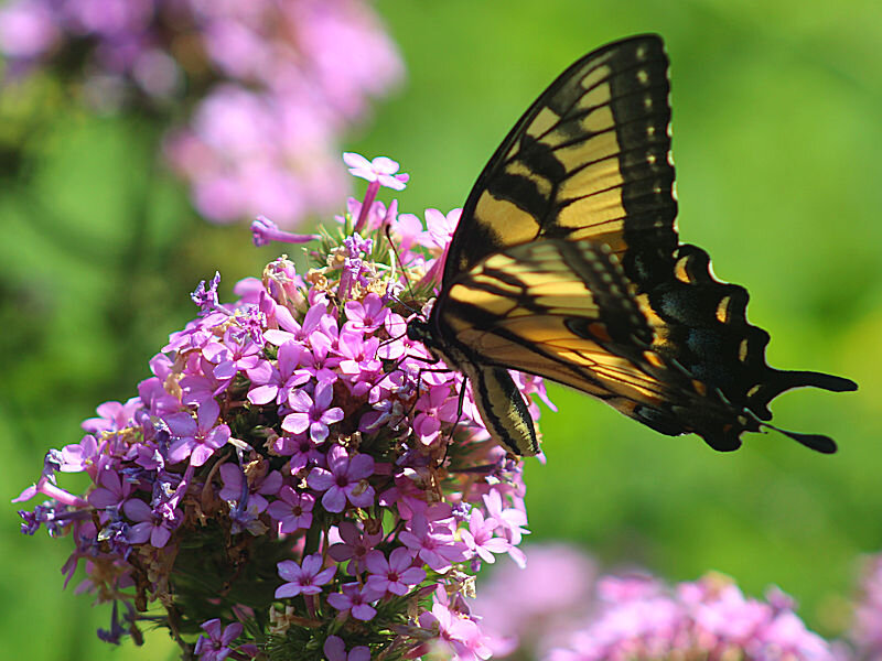
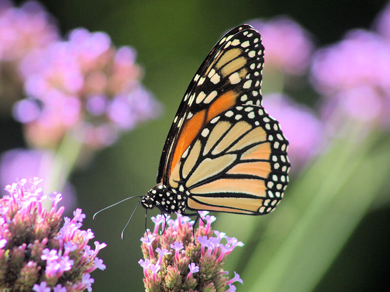
In New York City, the temperature soared to 90°F today. At the New York Botanical Garden, flowers were in abundance and butterflies were plentiful.