donsutherland1
-
Posts
24,156 -
Joined
Content Type
Profiles
Blogs
Forums
American Weather
Media Demo
Store
Gallery
Everything posted by donsutherland1
-
Morning thoughts… It will be mostly sunny and very warm. High temperatures will reach the middle and upper 90s in most of the region. Likely high temperatures around the region include: New York City (Central Park): 93° Newark: 98° Philadelphia: 97° Very warm to occasionally hot weather will continue into the weekend. Normals: New York City: 30-Year: 84.5°; 15-Year: 85.2° Newark: 30-Year: 86.0°; 15-Year: 87.1° Philadelphia: 30-Year: 87.0°; 15-Year: 87.6°
-
Temperatures again rose into the upper 80s and lower 90s across much of the region today. Tomorrow will see temperatures peak. Temperatures will rise well into the 90s across the region with some spots approaching or reaching 100°. The ECMWF seasonal forecast indicates that the summer will be warmer than normal throughout the region and across much of North America. Based on how the pattern has been evolving during the spring transition to summer, it is more likely than not that the warmest anomalies of the summer will likely occur in July and August with June being the coolest of the three months in the Northeast. The latest ECMWF monthly forecast indicates that July will be warmer than June relative to normal and that August will be the warmest summer month relative to normal. In addition, in the 6 past cases when the June AO averaged +0.750 or above (1950-2021), 50% of the following July cases were warmer than normal. 67% of the following August and September cases featured above normal temperatures. The ENSO Region 1+2 anomaly was -0.9°C and the Region 3.4 anomaly was -0.7°C for the week centered around July 27. For the past six weeks, the ENSO Region 1+2 anomaly has averaged -1.18°C and the ENSO Region 3.4 anomaly has averaged -0.62°C. La Niña conditions will likely persist into the fall. The SOI was +25.49 (old record: +25.06, 1998). The preliminary Arctic Oscillation (AO) was +0.168 today. On August 1 the MJO was in Phase 3 at an amplitude of 0.931 (RMM). The July 31-adjusted amplitude was 0.680 (RMM).
-
Texas/Oklahoma Discussion & Obs Thread 2022
donsutherland1 replied to It's Always Sunny's topic in Central/Western States
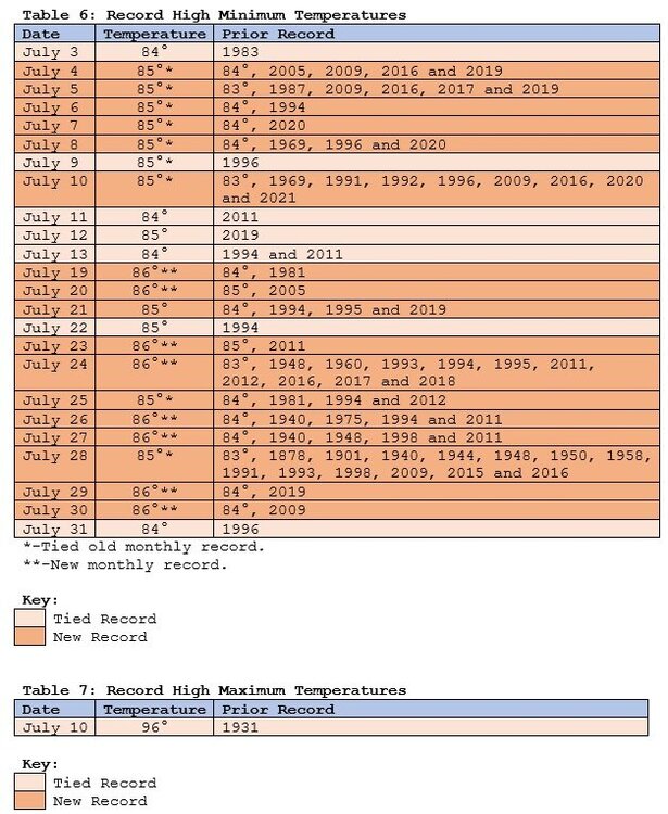
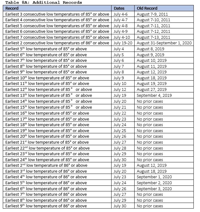
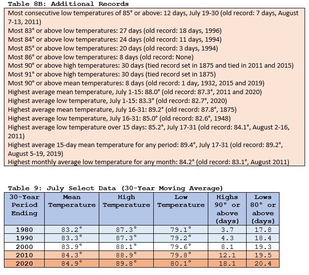
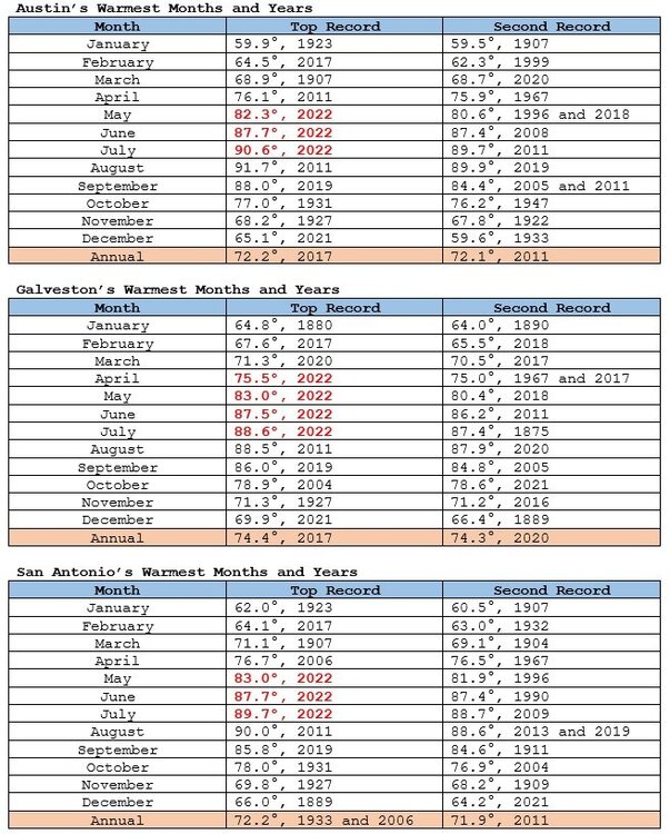
During 1961-1990, about one-in-five days saw the temperature reach or exceed 90 in Galveston. Now, approximately seven-in-ten reach 90 or above. There has been a dramatic shift in the distribution of high temperatures in August.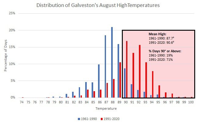
-
Hottest Weather So Far Lies Ahead for Phoenix
donsutherland1 replied to donsutherland1's topic in Central/Western States
The 1991-20 normal is up 0.7 degrees from the previous baseline. The monsoonal cooling knocked down the overall monthly mean. The first 22 and 23 days were actually the hottest such periods on record for July. -
Morning thoughts… It will be mostly sunny and very warm. High temperatures will reach the upper 80s and lower 90s in most of the region. Likely high temperatures around the region include: New York City (Central Park): 90° Newark: 95° Philadelphia: 94° Very warm to occasionally hot weather will continue into the weekend. Normals: New York City: 30-Year: 84.6°; 15-Year: 85.3° Newark: 30-Year: 86.1°; 15-Year: 87.2° Philadelphia: 30-Year: 87.1°; 15-Year: 87.8°
-
Galveston’s Record Warm Late Spring and Early Summer
donsutherland1 replied to donsutherland1's topic in Climate Change
Galveston will very likely see summer 2022 come out with a mean temperature of 86.0° or above in Galveston. A record warm summer remains on the table. The only summers that warm were: 2011: 87.3° 2020: 86.1° Galveston has been experiencing warming summers. Since 1980, 86% of summers were warmer than the 30-year moving average. Since 2000, that figure has increased further to 91%.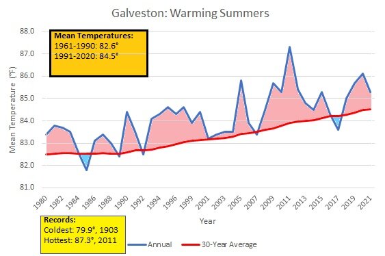
-
Temperatures rose into the upper 80s and lower 90s across much of the region today. Tomorrow will be another very warm day with similar temperatures. The heat will likely peak on Thursday with temperatures rising well into the 90s across the region with some spots approaching or reaching 100°. The ECMWF seasonal forecast indicates that the summer will be warmer than normal throughout the region and across much of North America. Based on how the pattern has been evolving during the spring transition to summer, it is more likely than not that the warmest anomalies of the summer will likely occur in July and August with June being the coolest of the three months in the Northeast. The latest ECMWF monthly forecast indicates that July will be warmer than June relative to normal and that August will be the warmest summer month relative to normal. In addition, in the 6 past cases when the June AO averaged +0.750 or above (1950-2021), 50% of the following July cases were warmer than normal. 67% of the following August and September cases featured above normal temperatures. The ENSO Region 1+2 anomaly was -0.9°C and the Region 3.4 anomaly was -0.7°C for the week centered around July 27. For the past six weeks, the ENSO Region 1+2 anomaly has averaged -1.18°C and the ENSO Region 3.4 anomaly has averaged -0.62°C. La Niña conditions will likely persist into the fall. The SOI was +25.79 (old record: +20.20, 1998). The preliminary Arctic Oscillation (AO) was +0.195 today. On July 31 the MJO was in Phase 3 at an amplitude of 0.679 (RMM). The July 30-adjusted amplitude was 0.661 (RMM).
-
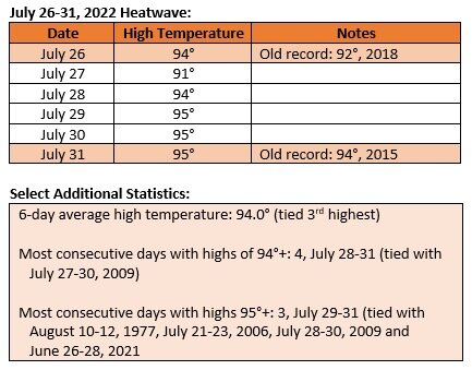
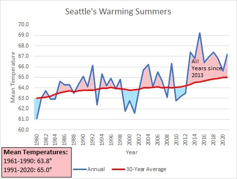
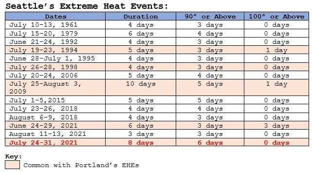
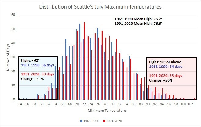
Recently, Seattle experienced its third extreme heat event (methodology from Clarke et al., 2014) in the past two years. Embedded in that extreme heat event was that city's longest heatwave on record. The extreme heat event and heatwave occur at a time when Seattle's summers are growing warmer and the frequency of 90° high temperatures in July are increasing.
-
Morning thoughts… It will be partly sunny and very warm. High temperatures will reach the upper 80s and lower 90s in most of the region. Likely high temperatures around the region include: New York City (Central Park): 79° Newark: 84° Philadelphia: 86° Very warm to occasionally hot weather will continue into the weekend. Normals: New York City: 30-Year: 84.7°; 15-Year: 85.5° Newark: 30-Year: 86.2°; 15-Year: 87.4° Philadelphia: 30-Year: 87.2°; 15-Year: 87.9°
-
Hotter air will be returning starting tomorrow. The heat could peak this week with temperatures rising well into the 90s across the region with some spots approaching or reaching 100°. Overall, August will likely be warmer than normal. The ECMWF seasonal forecast indicates that the summer will be warmer than normal throughout the region and across much of North America. Based on how the pattern has been evolving during the spring transition to summer, it is more likely than not that the warmest anomalies of the summer will likely occur in July and August with June being the coolest of the three months in the Northeast. The latest ECMWF monthly forecast indicates that July will be warmer than June relative to normal and that August will be the warmest summer month relative to normal. In addition, in the 6 past cases when the June AO averaged +0.750 or above (1950-2021), 50% of the following July cases were warmer than normal. 67% of the following August and September cases featured above normal temperatures. The ENSO Region 1+2 anomaly was -0.9°C and the Region 3.4 anomaly was -0.7°C for the week centered around July 27. For the past six weeks, the ENSO Region 1+2 anomaly has averaged -1.18°C and the ENSO Region 3.4 anomaly has averaged -0.62°C. La Niña conditions will likely persist through the summer. The SOI was +26.28 (old record: +15.23, 2010). The preliminary Arctic Oscillation (AO) was -0.100 today. On July 29 the MJO was in Phase 3 at an amplitude of 0.608 (RMM). The July 28-adjusted amplitude was 0.609 (RMM).
-
Morning thoughts… Clouds and showers will slowly give way to sunshine. High temperatures will reach the upper 70s and lower 80s in most of the region. Likely high temperatures around the region include: New York City (Central Park): 79° Newark: 84° Philadelphia: 86° Hot air will return tomorrow. Normals: New York City: 30-Year: 84.7°; 15-Year: 85.6° Newark: 30-Year: 86.3°; 15-Year: 87.5° Philadelphia: 30-Year: 87.3°; 15-Year: 88.0°
-
Texas/Oklahoma Discussion & Obs Thread 2022
donsutherland1 replied to It's Always Sunny's topic in Central/Western States
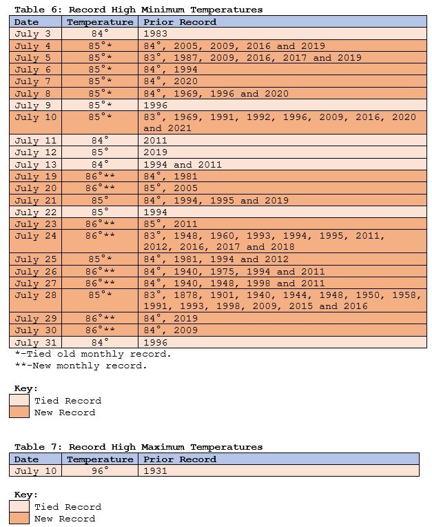
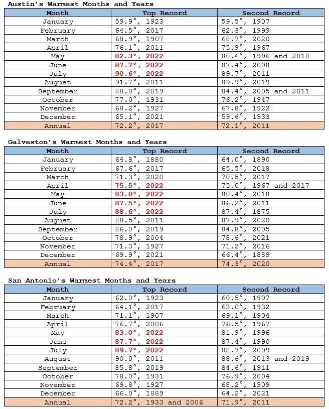
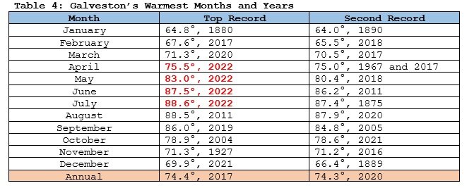
A remarkable July has now concluded in Texas. Austin and San Antonio saw their third consecutive record warm month while Galveston saw its fourth. July 2022 was also Galveston’s hottest month on record.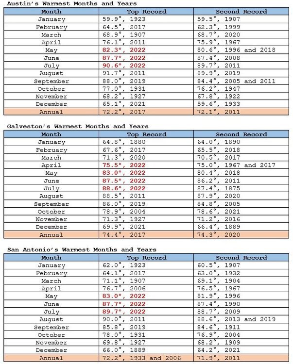
-
Hottest Weather So Far Lies Ahead for Phoenix
donsutherland1 replied to donsutherland1's topic in Central/Western States
July 2022 was tied as the 7th hottest July and 10th hottest month on record in Phoenix.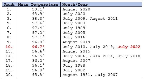
-
A warmer than normal July concluded today. In New York City, the monthly mean temperature was 79.5°, which was 2.0° above normal. Clouds and showers could give way to sunshine tomorrow. It will be briefly cooler before hotter air returns. Later in the week, temperatures could peak well in the 90s across the region with some spots approaching or reaching 100°. Overall, August will likely be warmer than normal. Out West, Austin and San Antonio recorded their third consecutive record warm month. Galveston registered its fourth consecutive record warm month. During June 16-20, the MJO has been in Phase 1 at an amplitude of 1.500 or above. Of the six cases that saw such an outcome during June 15-25 (1988, 2003, 2010, 2012, 2017 and 2020), four had a warmer than normal July, one was somewhat cooler than normal and one was cooler than normal. The latest guidance all indicates that July will wind up solidly among the warmer than normal cases. The ECMWF seasonal forecast indicates that the summer will be warmer than normal throughout the region and across much of North America. Based on how the pattern has been evolving during the spring transition to summer, it is more likely than not that the warmest anomalies of the summer will likely occur in July and August with June being the coolest of the three months in the Northeast. The latest ECMWF monthly forecast indicates that July will be warmer than June relative to normal and that August will be the warmest summer month relative to normal. In addition, in the 6 past cases when the June AO averaged +0.750 or above (1950-2021), 50% of the following July cases were warmer than normal. 67% of the following August and September cases featured above normal temperatures. The ENSO Region 1+2 anomaly was -1.0°C and the Region 3.4 anomaly was -0.7°C for the week centered around July 20. For the past six weeks, the ENSO Region 1+2 anomaly has averaged -1.30°C and the ENSO Region 3.4 anomaly has averaged -0.60°C. La Niña conditions will likely persist through the summer. The SOI was +28.87 (old record: +25.98, 2011). The preliminary Arctic Oscillation (AO) was -0.141 today. On July 29 the MJO was in Phase 3 at an amplitude of 0.609 (RMM). The July 28-adjusted amplitude was 0.862 (RMM).
-
Galveston’s Record Warm Late Spring and Early Summer
donsutherland1 replied to donsutherland1's topic in Climate Change
July 2022 was Galveston's hottest month on record. It was also Galveston's 4th consecutive record warm month.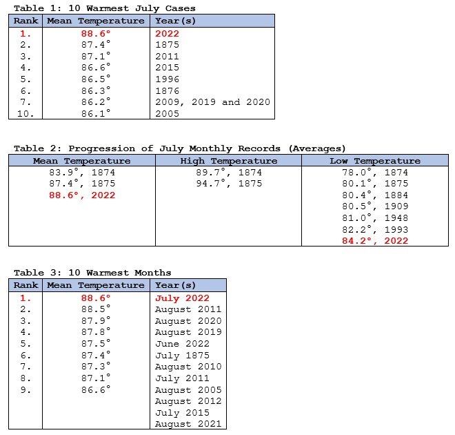
-
Galveston’s Record Warm Late Spring and Early Summer
donsutherland1 replied to donsutherland1's topic in Climate Change
Austin and San Antonio are concluding their third consecutive record warm month. Galveston is concluding its fourth consecutive record warm month.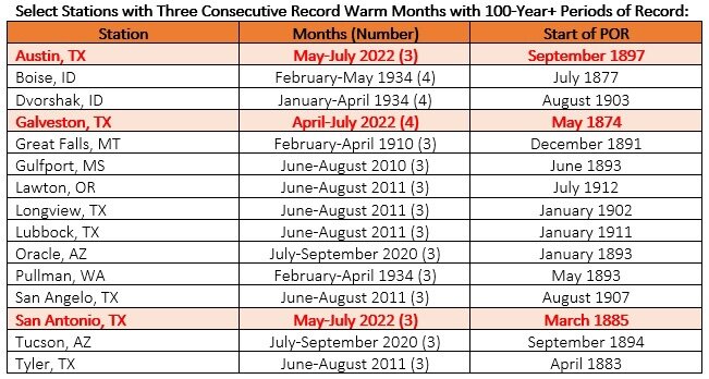
-
August 2022 temperature forecast contest
donsutherland1 replied to Roger Smith's topic in Weather Forecasting and Discussion
DCA _ NYC _ BOS __ ORD _ ATL _ IAH ___ DEN _ PHX _ SEA 1.5 2.0 2.0 1.8 1.2 0.7 0.2 0.5 1.0 -
Morning thoughts… Sunshine will give way to increasing clouds. High temperatures will reach the middle and upper 80s in most of the region. Likely high temperatures around the region include: New York City (Central Park): 84° Newark: 89° Philadelphia: 89° Clouds and showers will give way to some sunshine tomorrow. It will be cooler, but hot air will return on Tuesday. Normals: New York City: 30-Year: 84.8°; 15-Year: 85.7° Newark: 30-Year: 86.4°; 15-Year: 87.8° Philadelphia: 30-Year: 87.4°; 15-Year: 88.2°
-
July will conclude with near or above normal temperatures. Afterward, there is the potential for significant heat to expand into the region during the first week of August. Overall, August will likely be warmer than normal. Out West, Austin and San Antonio are virtually certain to record their third consecutive record warm month. Galveston is on track to record its fourth consecutive record warm month. Seattle and Portland are experiencing their second consecutive year with a concurrent extreme heat event for the first time on record. During June 16-20, the MJO has been in Phase 1 at an amplitude of 1.500 or above. Of the six cases that saw such an outcome during June 15-25 (1988, 2003, 2010, 2012, 2017 and 2020), four had a warmer than normal July, one was somewhat cooler than normal and one was cooler than normal. The latest guidance all indicates that July will wind up solidly among the warmer than normal cases. The ECMWF seasonal forecast indicates that the summer will be warmer than normal throughout the region and across much of North America. Based on how the pattern has been evolving during the spring transition to summer, it is more likely than not that the warmest anomalies of the summer will likely occur in July and August with June being the coolest of the three months in the Northeast. The latest ECMWF monthly forecast indicates that July will be warmer than June relative to normal and that August will be the warmest summer month relative to normal. In addition, in the 6 past cases when the June AO averaged +0.750 or above (1950-2021), 50% of the following July cases were warmer than normal. 67% of the following August and September cases featured above normal temperatures. The ENSO Region 1+2 anomaly was -1.0°C and the Region 3.4 anomaly was -0.7°C for the week centered around July 20. For the past six weeks, the ENSO Region 1+2 anomaly has averaged -1.30°C and the ENSO Region 3.4 anomaly has averaged -0.60°C. La Niña conditions will likely persist through the summer. The SOI was +25.24. The preliminary Arctic Oscillation (AO) was -0.165 today. On July 28 the MJO was in Phase 2 at an amplitude of 0.865 (RMM). The July 27-adjusted amplitude was 0.920 (RMM). Based on sensitivity analysis applied to the latest guidance, there is an implied near 100% probability that New York City will have a warmer than normal July (1991-2020 normal). July will likely finish with a mean temperature near 79.5° (2.0° above normal).
-
Temperatures will generally remain near or above normal through the remainder of the month. Afterward, there is the potential for significant heat to expand into the region during the first week of August. Overall, August will likely be warmer than normal. Out West, Austin and San Antonio are virtually certain to record their third consecutive record warm month. Galveston is on track to record its fourth consecutive record warm month. Seattle is now experiencing its third extreme heat event in the last two years and could make a run at tying or breaking its longest stretch of 90° or above days. During June 16-20, the MJO has been in Phase 1 at an amplitude of 1.500 or above. Of the six cases that saw such an outcome during June 15-25 (1988, 2003, 2010, 2012, 2017 and 2020), four had a warmer than normal July, one was somewhat cooler than normal and one was cooler than normal. The latest guidance all indicates that July will wind up solidly among the warmer than normal cases. The ECMWF seasonal forecast indicates that the summer will be warmer than normal throughout the region and across much of North America. Based on how the pattern has been evolving during the spring transition to summer, it is more likely than not that the warmest anomalies of the summer will likely occur in July and August with June being the coolest of the three months in the Northeast. The latest ECMWF monthly forecast indicates that July will be warmer than June relative to normal and that August will be the warmest summer month relative to normal. In addition, in the 6 past cases when the June AO averaged +0.750 or above (1950-2021), 50% of the following July cases were warmer than normal. 67% of the following August and September cases featured above normal temperatures. The ENSO Region 1+2 anomaly was -1.0°C and the Region 3.4 anomaly was -0.7°C for the week centered around July 20. For the past six weeks, the ENSO Region 1+2 anomaly has averaged -1.30°C and the ENSO Region 3.4 anomaly has averaged -0.60°C. La Niña conditions will likely persist through the summer. The SOI was +20.99. The preliminary Arctic Oscillation (AO) was -0.260 today. On July 27 the MJO was in Phase 2 at an amplitude of 0.928 (RMM). The July 26-adjusted amplitude was 1.189 (RMM). Based on sensitivity analysis applied to the latest guidance, there is an implied near 100% probability that New York City will have a warmer than normal July (1991-2020 normal). July will likely finish with a mean temperature near 79.5° (2.0° above normal).
-
It will be interesting to see if there is an attribution study. If so, these events may be covered in the same study, even as they occurred days apart.
-
Temperatures rose into the upper 80s and lower 90s across the region. Tomorrow will be a similar day. Temperatures will generally remain near or above normal through the remainder of the month. There is potential for significant heat to expand into the region during the first week of August. Overall, August will likely be warmer than normal. During June 16-20, the MJO has been in Phase 1 at an amplitude of 1.500 or above. Of the six cases that saw such an outcome during June 15-25 (1988, 2003, 2010, 2012, 2017 and 2020), four had a warmer than normal July, one was somewhat cooler than normal and one was cooler than normal. The latest guidance all indicates that July will wind up solidly among the warmer than normal cases. The ECMWF seasonal forecast indicates that the summer will be warmer than normal throughout the region and across much of North America. Based on how the pattern has been evolving during the spring transition to summer, it is more likely than not that the warmest anomalies of the summer will likely occur in July and August with June being the coolest of the three months in the Northeast. The latest ECMWF monthly forecast indicates that July will be warmer than June relative to normal and that August will be the warmest summer month relative to normal. In addition, in the 6 past cases when the June AO averaged +0.750 or above (1950-2021), 50% of the following July cases were warmer than normal. 67% of the following August and September cases featured above normal temperatures. The ENSO Region 1+2 anomaly was -1.0°C and the Region 3.4 anomaly was -0.7°C for the week centered around July 20. For the past six weeks, the ENSO Region 1+2 anomaly has averaged -1.30°C and the ENSO Region 3.4 anomaly has averaged -0.60°C. La Niña conditions will likely persist through the summer. The SOI was +15.63. The preliminary Arctic Oscillation (AO) was -0.147 today. On July 25 the MJO was in Phase 1 at an amplitude of 1.564 (RMM). The July 24-adjusted amplitude was 1.486 (RMM). Based on sensitivity analysis applied to the latest guidance, there is an implied near 100% probability that New York City will have a warmer than normal July (1991-2020 normal). July will likely finish with a mean temperature near 79.6° (2.1° above normal).
-
Temperatures will generally remain near or above normal through the remainder of the month. There is potential for significant heat to expand into the region late in the first week of August. Overall, August will likely be warmer than normal. In the Midwest, St. Louis picked up 8.64" rainfall today. That swept away the longstanding daily rainfall record of 6.85", which was set on August 20, 1915. During June 16-20, the MJO has been in Phase 1 at an amplitude of 1.500 or above. Of the six cases that saw such an outcome during June 15-25 (1988, 2003, 2010, 2012, 2017 and 2020), four had a warmer than normal July, one was somewhat cooler than normal and one was cooler than normal. The latest guidance all indicates that July will wind up solidly among the warmer than normal cases. The ECMWF seasonal forecast indicates that the summer will be warmer than normal throughout the region and across much of North America. Based on how the pattern has been evolving during the spring transition to summer, it is more likely than not that the warmest anomalies of the summer will likely occur in July and August with June being the coolest of the three months in the Northeast. The latest ECMWF monthly forecast indicates that July will be warmer than June relative to normal and that August will be the warmest summer month relative to normal. In addition, in the 6 past cases when the June AO averaged +0.750 or above (1950-2021), 50% of the following July cases were warmer than normal. 67% of the following August and September cases featured above normal temperatures. The ENSO Region 1+2 anomaly was -1.0°C and the Region 3.4 anomaly was -0.7°C for the week centered around July 20. For the past six weeks, the ENSO Region 1+2 anomaly has averaged -1.30°C and the ENSO Region 3.4 anomaly has averaged -0.60°C. La Niña conditions will likely persist through the summer. The SOI was +6.89. The preliminary Arctic Oscillation (AO) was -0.015 today. On July 24 the MJO was in Phase 1 at an amplitude of 1.485 (RMM). The July 23-adjusted amplitude was 1.419 (RMM). Based on sensitivity analysis applied to the latest guidance, there is an implied near 100% probability that New York City will have a warmer than normal July (1991-2020 normal). July will likely finish with a mean temperature near 79.6° (2.1° above normal).
-
Morning thoughts… It will be partly cloudy and warm. High temperatures will reach the lower and middle 80s in most of the region. Likely high temperatures around the region include: New York City (Central Park): 85° Newark: 90° Philadelphia: 88° Tomorrow will turn warmer. Normals: New York City: 30-Year: 85.0°; 15-Year: 86.1° Newark: 30-Year: 86.7°; 15-Year: 88.1° Philadelphia: 30-Year: 87.6°; 15-Year: 88.6°
-
Tomorrow will be partly sunny with seasonable temperatures. Temperatures will generally remain near orabove normal through the remainder of the month. There is potential for significant heat to expand into the region late in the first week of August. Overall, August will likely be warmer than normal. In the Midwest, St. Louis picked up 8.64" rainfall today. That swept away the longstanding daily rainfall record of 6.85", which was set on August 20, 1915. During June 16-20, the MJO has been in Phase 1 at an amplitude of 1.500 or above. Of the six cases that saw such an outcome during June 15-25 (1988, 2003, 2010, 2012, 2017 and 2020), four had a warmer than normal July, one was somewhat cooler than normal and one was cooler than normal. The latest guidance all indicates that July will wind up solidly among the warmer than normal cases. The ECMWF seasonal forecast indicates that the summer will be warmer than normal throughout the region and across much of North America. Based on how the pattern has been evolving during the spring transition to summer, it is more likely than not that the warmest anomalies of the summer will likely occur in July and August with June being the coolest of the three months in the Northeast. The latest ECMWF monthly forecast indicates that July will be warmer than June relative to normal and that August will be the warmest summer month relative to normal. In addition, in the 6 past cases when the June AO averaged +0.750 or above (1950-2021), 50% of the following July cases were warmer than normal. 67% of the following August and September cases featured above normal temperatures. The ENSO Region 1+2 anomaly was -1.0°C and the Region 3.4 anomaly was -0.7°C for the week centered around July 20. For the past six weeks, the ENSO Region 1+2 anomaly has averaged -1.30°C and the ENSO Region 3.4 anomaly has averaged -0.60°C. La Niña conditions will likely persist through the summer. The SOI was +7.02. The preliminary Arctic Oscillation (AO) was -0.074 today. On July 23 the MJO was in Phase 1 at an amplitude of 1.419 (RMM). The July 22-adjusted amplitude was 1.504 (RMM). Based on sensitivity analysis applied to the latest guidance, there is an implied 99% probability that New York City will have a warmer than normal July (1991-2020 normal). July will likely finish with a mean temperature near 79.7° (2.2° above normal).