donsutherland1
-
Posts
23,765 -
Joined
Content Type
Profiles
Blogs
Forums
American Weather
Media Demo
Store
Gallery
Everything posted by donsutherland1
-
Initially, the increase in precipitation should be beneficial. But eventually, seasonal snowfall will decline. Boston northward could still see some increase for the time being.
-
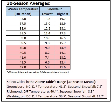
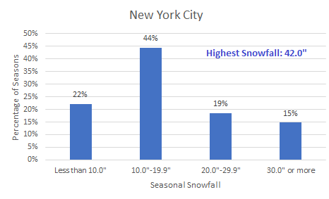
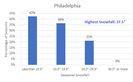
A climate link might be found, at least to some extent, if an attribution study finds that, for example, a marine heatwave altered the hemispheric pattern. AGW has led to a pronounced increase in the frequency and magnitude of marine heatwaves. Of course, internal variability will also be an important factor. In the long-range, even as there will remain a lot of variability in season-to-season snowfall, average snowfall will very likely decline as winters continue to warm. The winters in the lower Middle Atlantic region provide some insight into what lies ahead. Based on a regression equation that included Norfolk, Raleigh, Richmond, and Washington, DC (coefficient of determination: 0.836), it is likely that winters will become much less snowy, on average. The current seasonal average for New York City is 29.8”. With season-to-season variability, there will still be some snowy winters, but those winters will become less frequent. For New York City and Philadelphia, average snowfall for winters with mean temperatures of 37° or above and 40° or above were: Winters with a Mean Temperature of 37.0° or Above: New York City: Mean Temperature: 38.5°; Mean Snowfall: 17.5″ (n=27) Philadelphia: Mean Temperature: 39.0°; Mean Snowfall: 12.7″ (n=33) For Winters with a Mean Temperature of 40.0° or Above: New York City: Mean Temperature: 40.9°; Mean Snowfall: 10.3″ (n=5) Philadelphia: Mean Temperature: 41.2°; Mean Snowfall: 9.9″ (n=9) Those numbers are broadly consistent with the results from the regression equation. Below is the distribution of seasonal snowfall for winters that had mean temperatures of 37.0° or above: If this data is representative, New York City's 30-year average snowfall (Central Park) could decline to about 20" by the mid-2030s. There will still be some big years. Winter 2009-10 in Baltimore and Washington, DC, provides an example of such an outcome in a warmer climate.
-
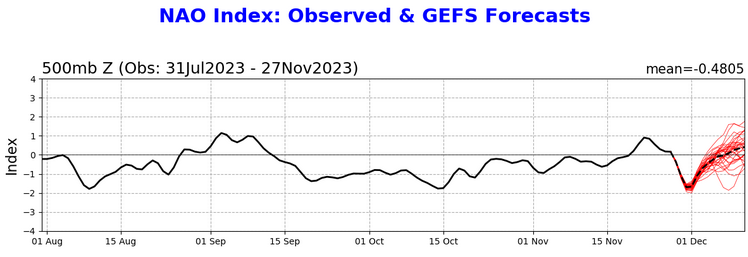
The Arctic Oscillation (AO) reached -3.350 yesterday (preliminary value). The occurrence of strong Atlantic blocking during the last week has often preceded a tendency for Atlantic blocking in December and January.
-
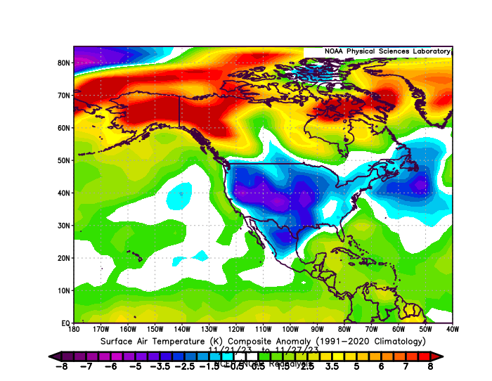
The final map. Cold anomalies were widespread, but the coldest anomalies were centered in the Plains States westward not the Southeast.
-
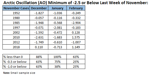
November finished with a mean temperature of 46.7° (1.2° below normal) in New York City. November 2023 was the coldest such month in November since 2021. Tomorrow will be another mild day. Showers could affect the region late in the day or on Saturday. The ENSO Region 1+2 anomaly was +2.0°C and the Region 3.4 anomaly was +2.1°C for the week centered around November 22. For the past six weeks, the ENSO Region 1+2 anomaly has averaged +2.22°C and the ENSO Region 3.4 anomaly has averaged +1.80°C. A basinwide El Niño event is ongoing. El Niño conditions will likely continue to strengthen into the early winter. Should the ENSO Region 1+2 and 3.4 anomalies remain at or above +1.00°C in December, which is likely, and should the PDO remain negative, there is a single past case (1950-2022) with similar ENSO/PDO conditions: December 1972. The SOI was +6.30 today. The preliminary Arctic Oscillation (AO) was -3.350 today. Only four prior November cases (1950-2022) saw the AO fall to -3.000 or below during the last week of November: 1985, 2002, 2010, and 2018. On November 28 the MJO was in Phase 3 at an amplitude of 0.457 (RMM). The November 27-adjusted amplitude was 0.555 (RMM).
-
Yes. I suspect that the ongoing marine heatwave near Region 4 is impacting the forcing.
-
My reasoning is that the first half will be around 2-3 degrees above normal. The closing 10 days of the month could become cold, especially if Arctic air moves across the Northeast. This is a risky idea, as the the ECMWF weeklies have backed off on the cold to end the month and start January.
-
It was always supposed to transition from an East Pacific to basinwide event on the computer guidance (CFSv2, ECMWF, etc.). That evolution has now occurred. Some had incorrectly expected a Modoki El Niño, but ENSO Region 1+2 will remain at or above +0.5C throughout the winter, so there will be no Modoki event.
-
DCA should be 1.0. I had what I thought was a typo, but was probably a counting problem.
-
DCA _NYC _BOS __ ORD _ATL _IAH ____ DEN _PHX _SEA 1.0 0.3 0.0 2.0 1.0 1.4 3.0 2.3 3.3 DCA _NYC _BOS __ ORD _DTW _BUF ____ DEN _ SEA _ BTV 11.5 15.0 27.5 27.0 38.5 85.0 56.5 1.2 70.0
-
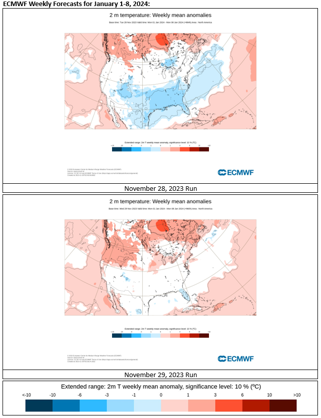
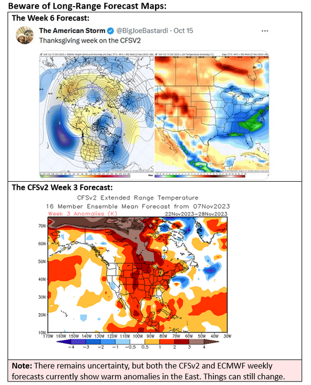
Reminder that beyond about 2 weeks, extended range models have little skill. In just one day, here's how the ECMWF weeklies changed for the January 1-8, 2024 timeframe.

-
A moderating trend will commence tomorrow. Showers could affect the region late in the day or Saturday. The ENSO Region 1+2 anomaly was +2.0°C and the Region 3.4 anomaly was +2.1°C for the week centered around November 22. For the past six weeks, the ENSO Region 1+2 anomaly has averaged +2.22°C and the ENSO Region 3.4 anomaly has averaged +1.80°C. A basinwide El Niño event is ongoing. El Niño conditions will likely continue to strengthen into the early winter. Should the ENSO Region 1+2 and 3.4 anomalies remain at or above +1.00°C in December, which is likely, and should the PDO remain negative, there is a single past case (1950-2022) with similar ENSO/PDO conditions: December 1972. The SOI was -0.89 today. The preliminary Arctic Oscillation (AO) was -2.468 today. On November 27 the MJO was in Phase 3 at an amplitude of 0.555 (RMM). The November 26-adjusted amplitude was 0.824 (RMM). Based on sensitivity analysis applied to the latest guidance, there is an implied near 100% probability that New York City will have a cooler than normal November (1991-2020 normal). November will likely finish with a mean temperature near 46.4° (1.5° below normal). That would be New York City's coldest November since November 2019.
-
No. High geomagnetic activity tends to favor a positive NAO or lack of Atlantic blocking. https://link.springer.com/content/pdf/10.1007/s11200-014-0508-z.pdf
-
I agree. It's definitely not going to be a "blowtorch" this time around. The East will probably be somewhat warmer than normal in most places. Nothing like 2015 is remotely on the table as far as I can see. Even 1994-type warmth seems unlikely. Colder prospects late in the month are possible (showing up on some of the extended guidance).
-
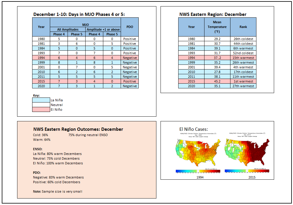
For those who are interested in December outcomes in the East based on the MJO's being predominantly in Phases 4 or 5 in early December (December 1-10):
-
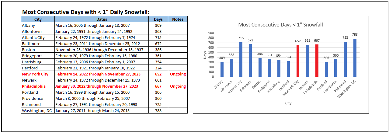
386 days.
-
Yes it is. Sadly, I think the Park will break that record, too.
-
Today was blustery and winterlike with highs finishing in the upper 30s and lower 40s. Baltimore, Bridgeport, Islip, New York City, Newark, and Philadelphia were among locations seeing their first snow flurries of the season. Tomorrow be partly sunny but unseasonably cold. Temperatures will again peak mainly in the 30s in much of the region. A moderating trend should commence on Thursday. The ENSO Region 1+2 anomaly was +2.0°C and the Region 3.4 anomaly was +2.1°C for the week centered around November 22. For the past six weeks, the ENSO Region 1+2 anomaly has averaged +2.22°C and the ENSO Region 3.4 anomaly has averaged +1.80°C. A basinwide El Niño event is ongoing. El Niño conditions will likely continue to strengthen into the early winter. Should the ENSO Region 1+2 and 3.4 anomalies remain at or above +1.00°C in December, which is likely, and should the PDO remain negative, there is a single past case (1950-2022) with similar ENSO/PDO conditions: December 1972. The SOI was -1.72 today. The preliminary Arctic Oscillation (AO) was -1.042 today. On November 26 the MJO was in Phase 3 at an amplitude of 0.824 (RMM). The November 25-adjusted amplitude was 1.015 (RMM). Based on sensitivity analysis applied to the latest guidance, there is an implied near 100% probability that New York City will have a cooler than normal November (1991-2020 normal). November will likely finish with a mean temperature near 46.3° (1.6° below normal). That would be New York City's coldest November since November 2019.
-
There was a passing snow flurry in the Bronx.
-
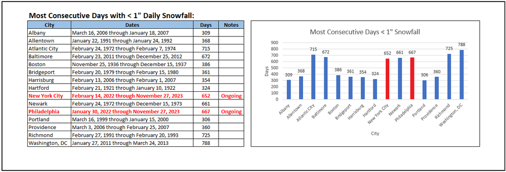
Yes. Central Park reported the lowest amount (0.9” vs JFK’s 1.0” on February 27).
-
Through November 27, both New York City and Philadelphia are continuing their longest streaks on record during which less than 1" daily snowfall was measured.
-
Tomorrow and Wednesday will be partly sunny but unseasonably cold. Temperatures will peak in the 30s tomorrow and Wednesday in much of the region. Flurries are possible, especially tomorrow. A few areas outside of New York City could see a heavier snow shower that could briefly coat the ground. A moderating trend should commence on Thursday. The ENSO Region 1+2 anomaly was +2.0°C and the Region 3.4 anomaly was +2.1°C for the week centered around November 22. For the past six weeks, the ENSO Region 1+2 anomaly has averaged +2.22°C and the ENSO Region 3.4 anomaly has averaged +1.80°C. A basinwide El Niño event is ongoing. El Niño conditions will likely continue to strengthen into the early winter. Should the ENSO Region 1+2 and 3.4 anomalies remain at or above +1.00°C in December, which is likely, and should the PDO remain negative, there is a single past case (1950-2022) with similar ENSO/PDO conditions: December 1972. The SOI was not available today. The preliminary Arctic Oscillation (AO) was -0.317 today. On November 25 the MJO was in Phase 2 at an amplitude of 1.015 (RMM). The November 24-adjusted amplitude was 1.141 (RMM). Based on sensitivity analysis applied to the latest guidance, there is an implied near 100% probability that New York City will have a cooler than normal November (1991-2020 normal). November will likely finish with a mean temperature near 46.3° (1.6° below normal). That would be New York City's coldest November since November 2019.
-
Latest NAO forecast shows the NAO going positive in the extended range. The AO remains negative. Were both to go positive, that would favor an even warmer outcome than is currently forecast.
-
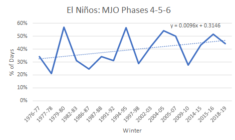
It should be noted that even as there is large variability in the percentage of days during which the MJO is in Phases 4-6 during El Niño events, the percentage has been trending higher during the winter months. The trend is based on the 16 El Niños for which daily MJO data is available.
-
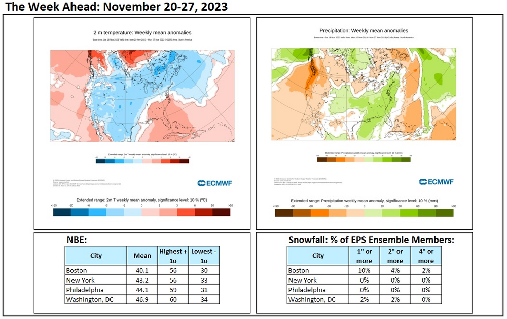
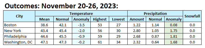
Final Outcomes: