

frd
-
Posts
6,931 -
Joined
-
Last visited
Content Type
Profiles
Blogs
Forums
American Weather
Media Demo
Store
Gallery
Everything posted by frd
-
Not a good start for eventual early season cold air delivery. Hey, but whatever. This seems to be the recent par for the course deal.
-
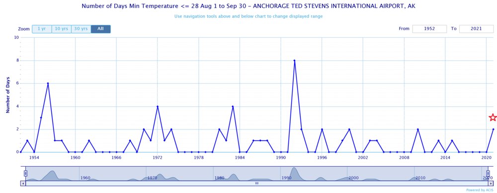
Low of 47F.
-
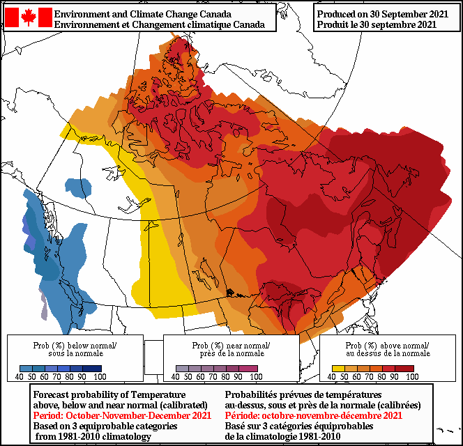
From bluewave , his thoughts echo in our region as well. A return to warmer than average temperatures following a brief cooler to near normal first day of the month. This matches up with September and October being the fastest warming months of fall. The monthly temperature increases from 81-10 to 91-20 have been more pronounced during certain months. Newark and Islip are compared below. The +1.0 or warmer months for either station were bolded. So we get an extension of summer into September. ……….EWR…..ISP Dec…+1.5….+1.5 Jan….+1.2…+1.3 Feb….+0.5….+0.5 Mar….+0.4….+0.6 Apr….+0.5…..+0.6 May...+0.6….+0.9 Jun….+0.3….+0.6 Jul…..+1.4…..+1.1 Aug...+0.6….+0.9 Sep….+1.0….+1.3 Oct…..+0.9..+1.4 Nov….+0.2..+0.5
-
Was a pathetic Nino, screwy SOI and strange MJO , and it did not behave like your old fashion El Ninos.
-
For our area away from the higher elevations we really need the Pac to cooperate.
-
Its a psychological relief to know in advance that the odds of a normal winter for the Mid Atlantic outside of the higher elevations is going to be a challenge. That notion typically fits well with a Nina. Data supports less and less snowfall the last 5 years from generally DC and points South and SW. I also mentioned last winter I feel that a + PNA is more important than a super negative AO. Donald S. may even have the stats to prove this. Nothing is simple anymore, prior positive weather teleconnections need to be taken with a step back. No one really knows what this winter will hold, outside of the persistance track of late.
-
Latest IRI/CPC models going for a weak Nina. Well, except the CPC, but the other 26 models, including the Euro, keep the Nina weak.
-
Interesting.
-
I was referring to Canada simply being colder versus torching. Hence my reference to the Canadian 10 day temperature anomoly. Folks assumed a -4 SD AO last winter would lead to colder and snow, it didn't.
-
Pathetic as usual....... Went from likely to chance of storms. Reminds me of last winter in a way, when three winter storm warnings here dropped a total of 4 inches of snow. National Weather Service Mount Holly NJ 327 PM EDT Tue Sep 28 2021 Latest Mount Holly Update --- NEAR TERM /THROUGH WEDNESDAY/... There`s still a thunderstorm threat into the evening behind this morning`s convection, but most of the CAMs are backing off. Still expecting a gradual moistening and surface heating in cloud breaks ahead of the surface front and MLCAPE in the 1000-1500 range, but areal coverage is waning. PoPs have been adjusted downward.
-
Warmish
-
Question is, whether the weakening really happens and what occurs after it. Is the pv going to snap back into a tight ball, or does it remain on the weaker side going into December.
-
Exactly, remember last winter, everyone gung-ho about blocking that finally was in real-time. And also rather robust. Guess what, Canadian 10 temp means where very warm, and depite the NW flow we had very little meaningful cold to trigger baroclinic feedback/storms and also no deep cold that would be hard to scour out. We need arctic cold in my opinion combined with blocking. Some fear this combo leading to cold and dry. I actually like to play that card because we may score here in the low lands.
-
Something has broken the horrible 4 year streak, may portend to be a positive moving deeper into the fall for the lower lattitudes. Still a Nina, but might be atypical in outcomes.
-
Growing concensus for early winter enthusiasts. Of interest, is the forecated opposite state of the MJO versus last year during October, as well as Iceland/UK blocking taking place and a weakened state of the pv.
-
Updated forecast brings temperatures into the 40s for overnight lows later in the week.
-
Maybe some small hail with stronger storms on Tuesday. SHORT TERM /MONDAY NIGHT THROUGH TUESDAY NIGHT/... A progressive short wave trough will move over the Great Lakes Monday night with an attendant surface low and cold front moving towards our region out of southern Canada. While moisture is still limited, there is still weak instability forecast along and ahead of the front, so will keep scattered showers and thunderstorms in the forecast on Tuesday. Steep lapse rates and the slightly drier mid- level profile could lead to some small hail with the stronger of these thunderstorms.
-
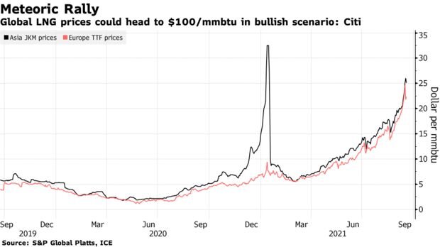
LNG prices are really going up. If winter is cold then expect huge demand and little additional supply to curb run away prices. https://bamwx.com/2021/09/24/weather-to-play-big-role-in-surging-natural-gas-prices-this-winter/ https://www.bloomberg.com/news/articles/2021-09-23/citi-isn-t-ruling-out-natural-gas-at-100-in-a-frigid-winter
-
Will be of interest to keep track to see any upstream effect from the recurving typhoon.
-
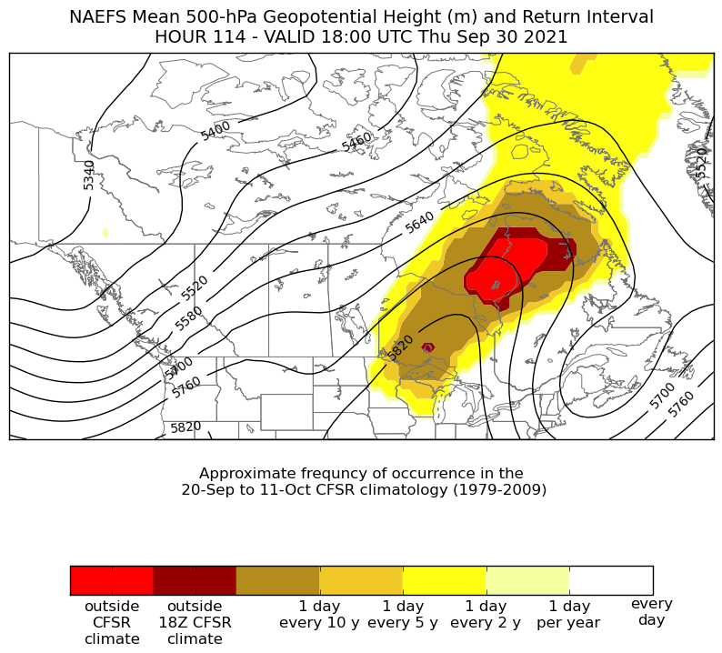
I believe that is a record block. As some have stated, we need record blocks these days to get any meaningful cooling. from bluewave
-
Nice to see that the highest skill for December is going for the weakest 100 mb vortex. Of course, in our climo even with a weakened vortex and blocking in the AO and even the NAO regions does not insure winter weather in these parts in early to mid December. But, I imagine that might be a plus for December holiday spirits and such, regardless. As many know here, we really need a true source of arctic air to tap to achieve snowfall in December away from psu-land. Keep an eye on the temps in SE Canada during late November for a clue to snow prospects here in early to mid December.
-
Pretty cool animation from Stu
-
Incredible !!!!!


.gif.feefdb4124b0d0eecbf21da5c8583565.gif)

