John1122
-
Posts
10,747 -
Joined
-
Last visited
Content Type
Profiles
Blogs
Forums
American Weather
Media Demo
Store
Gallery
Everything posted by John1122
-
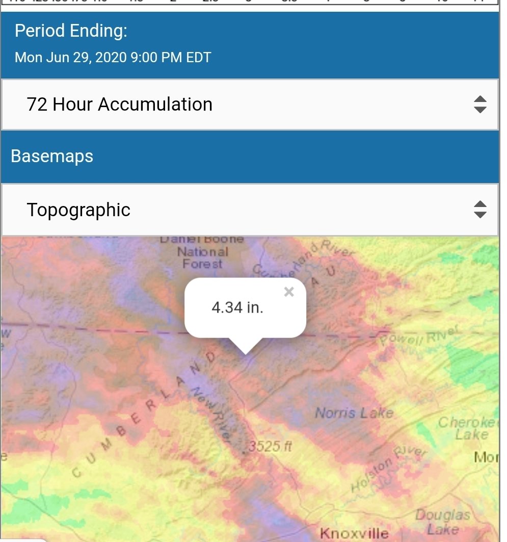
.41 in a slow rolling thunderstorm a little bit ago. I missed the brunt of it, areas in LaFollette to Caryville flooded and probably got over an inch in about 30 minutes.
-
We get about 10-15 more inches a year than the far Eastern areas like TYS to Tri but it's been ridiculous the last couple of years. The drought in 2016 dried the soils extremely deep and we burned and smoldered for a month. Since that broke each year just one ups the prior. I had virtually no rain last September and still had the rainiest year we ever had. Unless it dries significantly we will beat that record this year. Will likely cross 60 inches on the year this month, which is way ahead of TYS currently and their 40 inches is 15 AN for there.
- 186 replies
-
- 1
-

-
- tennessee river valley
- wind
- (and 4 more)
-
Picked up more heavy rain around 6 to 7 pm. Prompted flash flood warnings here. Ended up with 3.17 inches today.
- 186 replies
-
- 3
-
-
- tennessee river valley
- wind
- (and 4 more)
-
July came in like June left off. An extremely heavy shower parked overhead earlier. 2.1 inches of rain from it. Ended up at 8.93 for June. Wild when that's one of the drier months in the last 7 or 8 months.
- 186 replies
-
- 1
-
-
- tennessee river valley
- wind
- (and 4 more)
-
Another .5 inches this evening. 2.9 for the day. Gonna approach 10 inches again this month if the rain come back in overnight and tomorrow.
- 186 replies
-
- 1
-
-
- tennessee river valley
- wind
- (and 4 more)
-
Still pounding down here and it's lined up to Louisville, Kentucky and pointed right at our area.
-
1.1 inches overnight. Another 1.3 inches this evening with another round moving in, more flooding in the area. That's over 3 inches in the past 36 hours. June is going to be another month with well AN rainfall.
-
.85 rain yesterday. Been having heavy rain and thunderstorms training here for several hours overnight. Not looked at the rain gauge yet but won't be surprised it it's 1 to 1.5 inches or more just based on how hard it's rain and how many rounds have rolled through.
-
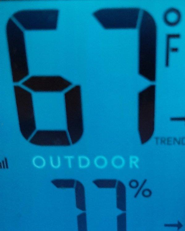
Another afternoon with the temp at 69/70. So rare for it to rain all day in summer too unless a hurricane is involved.
-
It was cloudy here at sunset. I was expecting some vivid colors but no such luck.
- 186 replies
-
- 1
-
-
- tennessee river valley
- wind
- (and 4 more)
-
The dust certainly lived up to its billing. There's just a bit of brown tinge to all the haze and it's way thicker than normal summer haze.
- 186 replies
-
- 2
-
-
- tennessee river valley
- wind
- (and 4 more)
-
They are very easily scared, fortunately. At least the ones here are. They aren't the Gatlinburg city bears that people watch. Those are the ones to worry about.
- 186 replies
-
- 2
-
-
- tennessee river valley
- wind
- (and 4 more)
-
Hot and sticky for my walk this evening. A few rain drops and I walked up near face to face with a bear in the road about 1/4th mile from my house. Clapped my hands and it took off back into the woods. Dogs gave a brief chase but lost interest quickly. Wild Raspberries are getting ripe in the area. Guess it's been into them.
- 186 replies
-
- 3
-
-
- tennessee river valley
- wind
- (and 4 more)
-
Several rounds of excessive rainfall today. 2.74 inches so far. Had a persistent 45 minute heavy thunderstorm around 3 that really upped totals.
-
3 pm and 66 degrees. I don't remember when we've had a stretch of days like this in mid-June before.
- 186 replies
-
- 3
-
-
- tennessee river valley
- wind
- (and 4 more)
-
Another afternoon and early summer evening with temps falling from the 70s into the 60s. We keep getting summer in fall, it's nice to get fall in summer.
- 186 replies
-
- 2
-
-
- tennessee river valley
- wind
- (and 4 more)
-
Went walking this evening, felt like early October. Temp was 63 at 8pm, plus the humidity was down from yesterday.
- 186 replies
-
- 4
-
-
- tennessee river valley
- wind
- (and 4 more)
-
Another crazy early summer late afternoon.
- 186 replies
-
- 2
-
-
- tennessee river valley
- wind
- (and 4 more)
-
Hard to beat today, currently sitting at 72 degrees with low humidity. Evening walk is going to feel much better than yesterday when it was 86 with a 75 dp.
- 186 replies
-
- 1
-
-
- tennessee river valley
- wind
- (and 4 more)
-
June rolled in at 45 degrees here this morning.
-
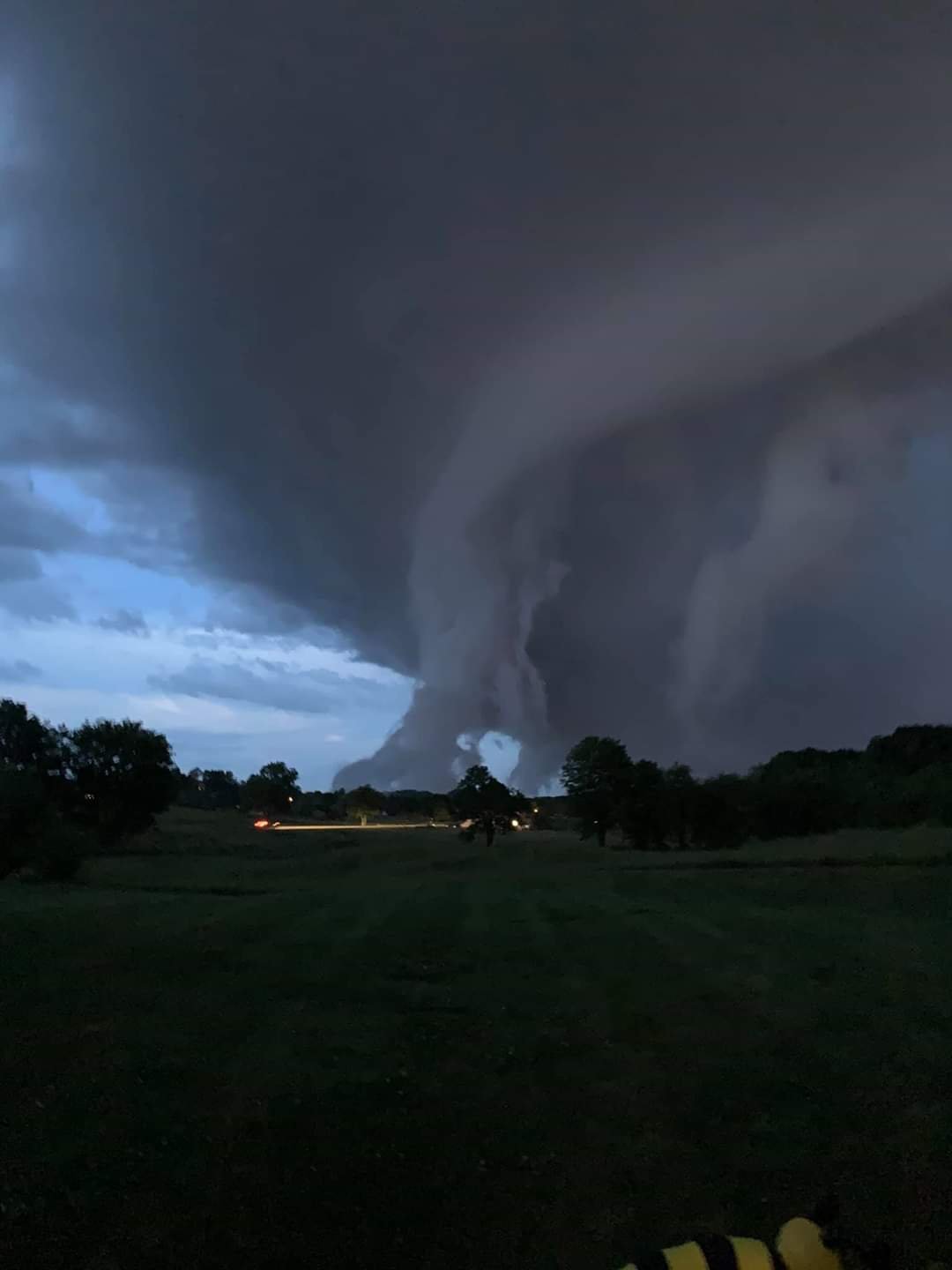
Someone posted this about an hour ago claiming it was London, Ky and even gave the street they they took the picture from. Not sure if it's true, mainly interested on what kind of cloud this is.

-
.85 rainfall with a lot of limbs out of trees in the storm. Up to about forearm thickness.
-
Rocking and rolling here this afternoon. Very strong winds, heavy rain and small hail.
- 186 replies
-
- 1
-
-
- tennessee river valley
- wind
- (and 4 more)
-
Wild Speculation for Winter 20 -21
John1122 replied to Holston_River_Rambler's topic in Tennessee Valley
I just wish we could get our BN warm season weather, which has been frequent the last few years, to actually cooperate in winter and land there for a change. -
.48 inches of rain yesterday, mostly between midnight and 7 am. Temp stayed in the upper 50s to low 60s during the day.