John1122
-
Posts
10,741 -
Joined
-
Last visited
Content Type
Profiles
Blogs
Forums
American Weather
Media Demo
Store
Gallery
Everything posted by John1122
-
Christmas Eve/Christmas 2020 Arctic Express Snow Obs.
John1122 replied to John1122's topic in Tennessee Valley
I'm about to officially reach white Christmas status. Closing in on an inch already. Currently visibility is approximately 700 feet. I think I may bust high on the MRX call map if I can maintain this for even another hour. Not counting and potential banding or anything like that. -
Christmas Eve/Christmas 2020 Arctic Express Snow Obs.
John1122 replied to John1122's topic in Tennessee Valley
I am sure areas to the East will do much better but it's hard to beat getting to see these huge flakes falling while red birds fill the apple tree by my feeder in the daylight. Daylight snow is just rare here any more. -
Christmas Eve/Christmas 2020 Arctic Express Snow Obs.
John1122 replied to John1122's topic in Tennessee Valley
Ripping half and silver dollars now. Or fatties as some would say. -
Christmas Eve/Christmas 2020 Arctic Express Snow Obs.
John1122 replied to John1122's topic in Tennessee Valley
35 to 34 did it for Jacksboro.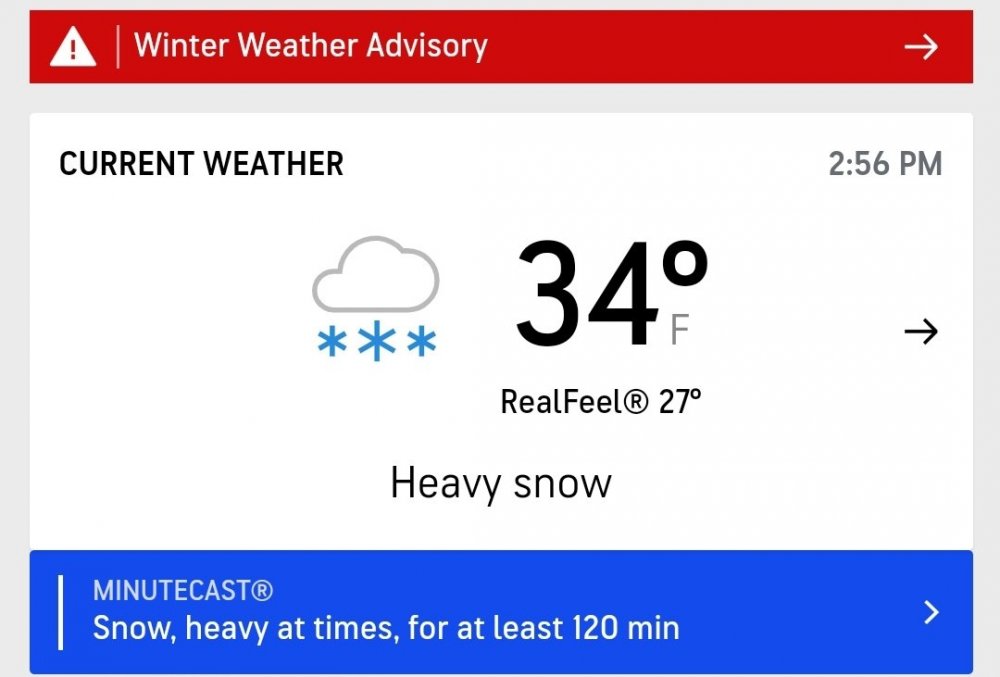
-
Christmas Eve/Christmas 2020 Arctic Express Snow Obs.
John1122 replied to John1122's topic in Tennessee Valley
32 and the ground is milky white. Large snow flakes with probably 5 percent sleet. Just enough to barely hear it. -
Christmas Eve/Christmas 2020 Arctic Express Snow Obs.
John1122 replied to John1122's topic in Tennessee Valley
Just turned the corner. Heavy snow now. Quarter to half dollar sized flakes. -
Christmas Eve/Christmas 2020 Arctic Express Snow Obs.
John1122 replied to John1122's topic in Tennessee Valley
Obs from Jacksboro to my South.
-
December 2020 Medium/Long Term Pattern Discussion.
John1122 replied to John1122's topic in Tennessee Valley
If it went north after 240 all of East Tennessee and East Kentucky probably gets 10 more inches. -
December 2020 Medium/Long Term Pattern Discussion.
John1122 replied to John1122's topic in Tennessee Valley
It's only below freezing on the Plateau and NE of Morristown that run. Knoxville gets 20 inches of snow in 18 hours at 33. There wouldn't be a standing powerline in the entire valley from Morristown to Lawrenceburg. -
Christmas Eve/Christmas 2020 Arctic Express Snow Obs.
John1122 replied to John1122's topic in Tennessee Valley
Me too, sleet is a good base for snow to lay on if the ground didn't look like a lake. But it eats up precious snow QPF and use West siders can't afford that. -
Christmas Eve/Christmas 2020 Arctic Express Snow Obs.
John1122 replied to John1122's topic in Tennessee Valley
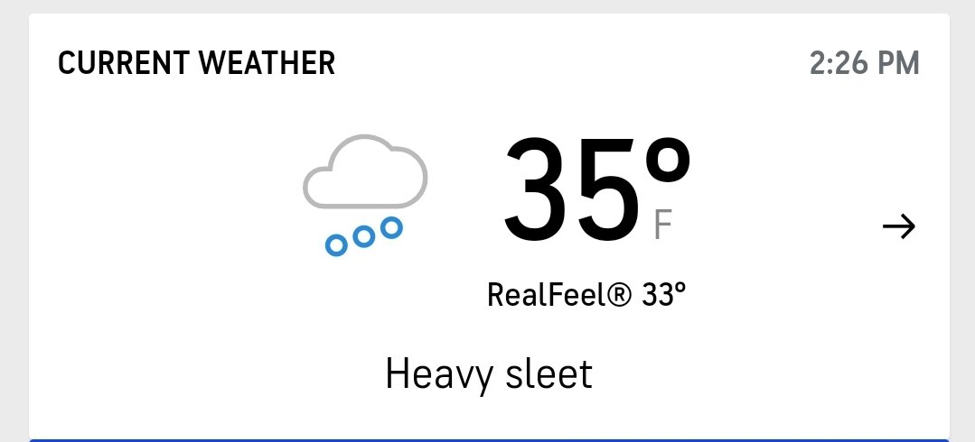
I'd forgotten how loud heavy sleet was. I'm currently 80 percent sleet, 20 percent snow. -
Christmas Eve/Christmas 2020 Arctic Express Snow Obs.
John1122 replied to John1122's topic in Tennessee Valley
I'm actually in a sleet burst right now too. -
December 2020 Medium/Long Term Pattern Discussion.
John1122 replied to John1122's topic in Tennessee Valley
Holy mother....probably mixed or sleet south of 40 on the Euro, but lordy. -
Christmas Eve/Christmas 2020 Arctic Express Snow Obs.
John1122 replied to John1122's topic in Tennessee Valley
Moisture has moved back over me 70/30 snow rain mix. Running about 45 minutes behind the HRRR changeover time. -
Christmas Eve/Christmas 2020 Arctic Express Snow Obs.
John1122 replied to John1122's topic in Tennessee Valley
Soon as I post that I look out and it's snowing mixed with sleet. Just lightly though. -
Christmas Eve/Christmas 2020 Arctic Express Snow Obs.
John1122 replied to John1122's topic in Tennessee Valley
36 and strong north winds here. Precip down to drizzle. -
Christmas Eve/Christmas 2020 Arctic Express Snow Obs.
John1122 replied to John1122's topic in Tennessee Valley
Cold is around 30 minutes behind schedule vs modeling. I was modeled to change over at 1 and I don't think I'm going to get there. Another surge of heavy rain and 41 degrees. -
Christmas Eve/Christmas 2020 Arctic Express Snow Obs.
John1122 replied to John1122's topic in Tennessee Valley
Just flooding down rain. Gonna be so close to ending here when the cold arrives. Just have to hope the backing happens. I may be too far West and this might be the time things verify more East than west on a modeled precip shield. -
Christmas Eve/Christmas 2020 Arctic Express Snow Obs.
John1122 replied to John1122's topic in Tennessee Valley
Trying to see if it popped/where the Lee side low may be. Right now the only surface map i can find with a L shows it near Harlan Ky. -
Christmas Eve/Christmas 2020 Arctic Express Snow Obs.
John1122 replied to John1122's topic in Tennessee Valley
34 just west of me in Scott co. Down to 42 here. -
Christmas Eve/Christmas 2020 Arctic Express Snow Obs.
John1122 replied to John1122's topic in Tennessee Valley
Below freezing about 80 miles west of me. 47 here with moderate rain. Looks like its 47 in Oneida and 36 in Jamestown. -
Dandridge Dollop 12/24/20 Storm Thread (Winter Wonderland)
John1122 replied to AMZ8990's topic in Tennessee Valley
This area will progress quickly. The reason Eastern areas see snow initially is a low will develop on the front and basically stop it until the low passes. The rest is from convective snow bands from a trailing upper level disturbance.- 847 replies
-
- 2
-

-
- cold temperatures
- snow
- (and 8 more)
-
Dandridge Dollop 12/24/20 Storm Thread (Winter Wonderland)
John1122 replied to AMZ8990's topic in Tennessee Valley
RGEM keeps on flexing like Hulk Hogan.- 847 replies
-
- 2
-
-
- cold temperatures
- snow
- (and 8 more)
-
Dandridge Dollop 12/24/20 Storm Thread (Winter Wonderland)
John1122 replied to AMZ8990's topic in Tennessee Valley
3k NAM.- 847 replies
-
- 2
-
-
- cold temperatures
- snow
- (and 8 more)
-
Dandridge Dollop 12/24/20 Storm Thread (Winter Wonderland)
John1122 replied to AMZ8990's topic in Tennessee Valley
3k NAM is going to be more aggressive with the initial snow and has the convection captured in the Mid-state popping.