yoda
-
Posts
62,015 -
Joined
Content Type
Profiles
Blogs
Forums
American Weather
Media Demo
Store
Gallery
Everything posted by yoda
-
Lol too early to say that
- 2,802 replies
-
- 1
-

-
- severe
- thunderstorms
- (and 4 more)
-
They were as far south as the 1st row of counties in N VA (Fairfax/Loudoun/Clarke)
-
1630 SPC OTLK a bit more robust for us this afternoon re disco
-
Too late, you said TOR... so you just guaranteed a TOR day
-
Also looks decent for this afternoon around 21z-23z
-
Morning update from LWX AFD:
- 2,802 replies
-
- 1
-

-
- severe
- thunderstorms
- (and 4 more)
-
I thought Eskimo Joe would be more complaining about the Flood Watch in effect for him
-
From the 0100 OTLK from SPC:
-
Doubt they will even get here... but might want to watch the storms in W PA moving SE... have had occasional TW's with them
-
Interesting Day 1 and 2 updates from SPC... day 1 - today - is 2/15/5 with talk of cellular activity producing hail and supercell possible Tomorrow (Monday) talks about a potential bow complex coming through in the afternoon
- 2,802 replies
-
- 2
-
-
- severe
- thunderstorms
- (and 4 more)
-
00z GFS sim radar likes Monday night, Tuesday night, and Thursday night
-

2019 Short/Medium Range Severe Weather Thread
yoda replied to snowlover2's topic in Lakes/Ohio Valley
https://www.spc.noaa.gov/products/md/md1085.html Mesoscale Discussion 1085 NWS Storm Prediction Center Norman OK 0948 PM CDT Sat Jun 15 2019 Areas affected...Northern Missouri...eastern Kansas...and western Illinois Concerning...Severe Thunderstorm Watch 362... Valid 160248Z - 160345Z The severe weather threat for Severe Thunderstorm Watch 362 continues. SUMMARY...The severe threat continues for WW 362. Additional watches are being considered. DISCUSSION...Regional radar shows a line of storms has developed a weak cold front extending from portions of western Illinois into northern Missouri and far eastern Kansas. In addition, a fairly well developed MCV is now associated with the northern end of this activity, now tracking into northern Illinois, and storms here are beginning to bow out. A few reports of large hail (1-1.5 inches in diameter) and strong wind gusts (60 mph) have occurred this evening. Given the ample supply of low-level moisture (high 60s to low 70s F dew point temperatures), instability (1500-3000+ J/kg MLCAPE), and deep-layer shear (40-45 kt effective bulk shear), the ongoing storms should continue to pose a severe threat, particularly across portions of north-central Illinois where a damaging wind threat may be emerging and thus, a new watch may be needed. Additional storms may develop farther west along the front extending into southeast Kansas, and thus may require an additional watch here. ..Karstens.. 06/16/2019 ...Please see www.spc.noaa.gov for graphic product... ATTN...WFO...LOT...ILX...LSX...DVN...SGF...EAX...TOP...ICT... -
00z NAM NEST lights up DC metro between 22z and 01z
-

-
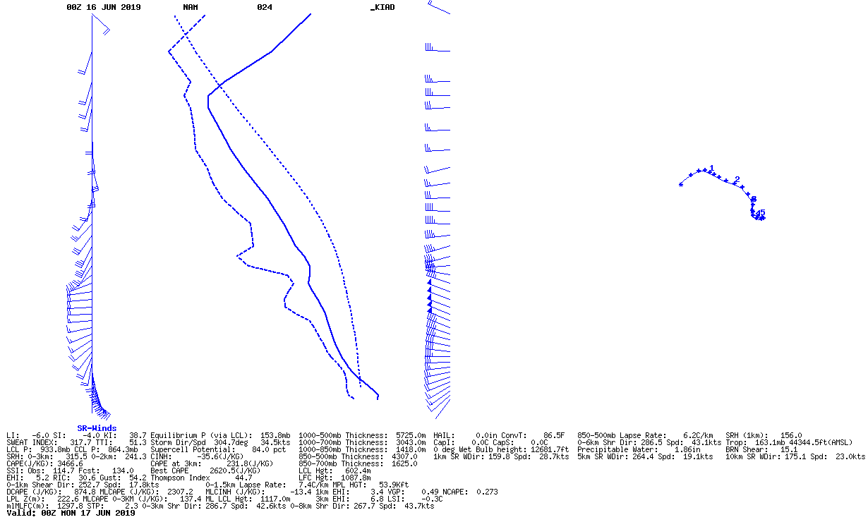
Well then, the 03z MON sounding at KIAD is certainly fun to look at from the 00z NAM
-
Waiting on the new 00z NAM... but 18z NAM soundings were pretty nice for 21z and 00z tomorrow
-
18z NAM soundings look tasty from 21z SUN to 09z MON
-
12z GFS soundings for KIAD and KDCA and KBWI at 00z MON (8pm Sunday) are pretty impressive considering its 60 hours out
-
00z GFS sim radar looks intriguing at 72 hours on 00z MON (8pm SUN) and then again at hours 93 and 96 as you go from 21z MON into 00z TUES and as you go on Wednesday into Thursday
-
Radarscope claiming rotation with the storm near Middleburg just a lil while ago
-
Looks pretty nice for Monday? Or is that Tuesday?
-
Sunday into Monday looks intriguing
-
00z NAM looks a lil bit more intriguing for Thursday evening... at 21z THUR at KIAD, SBCAPE is around 1500, ML Lapse Rates around 6.5 C/KM, 0-6km shear around 65 kts, and MLCAPE just below 1000 with 0-3km CAPE around 170... SRH at all levels looks decent
-
12z NAM seems to think otherwise... its at the end of its run, at KIAD at 78 hours, it has ~1000 SBCAPE at 18z THUR with MLCAPE at around 650. 0-6km shear is flying at over 60 kts.
-
LWX in their afternoon AFD mentioned the chance for some severe early next week... on Monday I believe