yoda
-
Posts
62,104 -
Joined
Content Type
Profiles
Blogs
Forums
American Weather
Media Demo
Store
Gallery
Everything posted by yoda
-
Not crap anymore, huh?
-
Brother who teaches at Columbia Elementary says powers out
-
Tornado warning Central Howard county Columbia and Ellicott City are in path
-
New STW for Howard and Anne Arundel and Southern Baltimore out for winds to 70mph
-
What size?
- 2,802 replies
-
- 1
-

-
- severe
- thunderstorms
- (and 4 more)
-
According to the latest SWS, the storms are moving more SE now than E
-
BULLETIN - IMMEDIATE BROADCAST REQUESTED Severe Thunderstorm Warning National Weather Service Baltimore MD/Washington DC 256 PM EDT Thu May 23 2019 The National Weather Service in Sterling Virginia has issued a * Severe Thunderstorm Warning for... Northwestern Howard County in central Maryland... Montgomery County in central Maryland... Southeastern Frederick County in north central Maryland... Northeastern Loudoun County in northern Virginia... * Until 330 PM EDT. * At 256 PM EDT, severe thunderstorms were located along a line extending from near Ballenger Creek to near Lansdowne, moving east at 50 mph. HAZARD...60 mph wind gusts. SOURCE...Radar indicated. IMPACT...Damaging winds will cause some trees and large branches to fall. This could injure those outdoors, as well as damage homes and vehicles. Roadways may become blocked by downed trees. Localized power outages are possible. Unsecured light objects may become projectiles. * Locations impacted include... Germantown, Rockville, Bethesda, Gaithersburg, Leesburg, Olney, Damascus, Lansdowne, Poolesville, Aspen Hill, Potomac, North Bethesda, Montgomery Village, North Potomac, Ballenger Creek, Redland, Chevy Chase, North Kensington, South Kensington and North Chevy Chase. PRECAUTIONARY/PREPAREDNESS ACTIONS... Remain alert for a possible tornado! Tornadoes can develop quickly from severe thunderstorms. If you spot a tornado go at once into the basement or small central room in a sturdy structure. For your protection move to an interior room on the lowest floor of a building. Large hail and damaging winds and continuous cloud to ground lightning is occurring with these storms. Move indoors immediately. Lightning is one of nature`s leading killers. Remember, if you can hear thunder, you are close enough to be struck by lightning.
-
@high risk From LWX's afternoon AFD re evening and tonight... sounds like you were right on your post but maybe?
-
What about this evening that LWX mentioned in their AFD and SPC mentioned in the 1630 OTLK? Hit and miss storms?
-
SEVERE THUNDERSTORM WATCH OUTLINE UPDATE FOR WS 218 NWS STORM PREDICTION CENTER NORMAN OK 100 PM EDT THU MAY 23 2019 SEVERE THUNDERSTORM WATCH 218 IS IN EFFECT UNTIL 800 PM EDT FOR THE FOLLOWING LOCATIONS MDC003-005-009-011-013-015-017-021-025-027-029-031-033-035-041- 043-510-240000- /O.NEW.KWNS.SV.A.0218.190523T1700Z-190524T0000Z/ MD . MARYLAND COUNTIES INCLUDED ARE ANNE ARUNDEL BALTIMORE CALVERT CAROLINE CARROLL CECIL CHARLES FREDERICK HARFORD HOWARD KENT MONTGOMERY PRINCE GEORGES QUEEN ANNE`S TALBOT WASHINGTON MARYLAND INDEPENDENT CITIES INCLUDED ARE BALTIMORE CITY SEVERE THUNDERSTORM WATCH OUTLINE UPDATE FOR WS 218 NWS STORM PREDICTION CENTER NORMAN OK 100 PM EDT THU MAY 23 2019 SEVERE THUNDERSTORM WATCH 218 IS IN EFFECT UNTIL 800 PM EDT FOR THE FOLLOWING LOCATIONS VAC013-043-047-059-061-069-079-099-107-113-137-139-153-157-177- 179-187-510-600-610-630-683-685-840-240000- /O.NEW.KWNS.SV.A.0218.190523T1700Z-190524T0000Z/ VA . VIRGINIA COUNTIES INCLUDED ARE ARLINGTON CLARKE CULPEPER FAIRFAX FAUQUIER FREDERICK GREENE KING GEORGE LOUDOUN MADISON ORANGE PAGE PRINCE WILLIAM RAPPAHANNOCK SPOTSYLVANIA STAFFORD WARREN VIRGINIA INDEPENDENT CITIES INCLUDED ARE ALEXANDRIA FAIRFAX FALLS CHURCH FREDERICKSBURG MANASSAS SEVERE THUNDERSTORM WATCH OUTLINE UPDATE FOR WS 218 NWS STORM PREDICTION CENTER NORMAN OK 100 PM EDT THU MAY 23 2019 SEVERE THUNDERSTORM WATCH 218 IS IN EFFECT UNTIL 800 PM EDT FOR THE FOLLOWING LOCATIONS WVC003-037-065-240000- /O.NEW.KWNS.SV.A.0218.190523T1700Z-190524T0000Z/ WV . WEST VIRGINIA COUNTIES INCLUDED ARE BERKELEY JEFFERSON MORGAN SEVERE THUNDERSTORM WATCH OUTLINE UPDATE FOR WS 218 NWS STORM PREDICTION CENTER NORMAN OK 100 PM EDT THU MAY 23 2019 SEVERE THUNDERSTORM WATCH 218 IS IN EFFECT UNTIL 800 PM EDT FOR THE FOLLOWING LOCATIONS DCC001-240000- /O.NEW.KWNS.SV.A.0218.190523T1700Z-190524T0000Z/ DC . DISTRICT OF COLUMBIA COUNTIES INCLUDED ARE DISTRICT OF COLUMBIA
-
Pretty large amount of LWX CWA in the STWatch
-
SPC going for the twin bill it appears in their 1630 disco
-
Still 5 tor, 15 hail, 15 wind at 1630 OTLK 30 wind and ENH risk remains where it is... maybe a super slight south shift
-
https://www.weather.gov/lwx/events_20080604 https://www.weather.gov/lwx/events_20080604_lsr http://voices.washingtonpost.com/capitalweathergang/2008/06/june_4_2008_severe_weather_out_1.html
-
Area Forecast Discussion National Weather Service Baltimore MD/Washington DC 1028 AM EDT Thu May 23 2019 && .NEAR TERM /THROUGH TONIGHT/... High pressure will remain offshore today and a southerly flow will continue to usher in warmer and more humid conditions. Max temps will top off in the mid to upper 80s across most locations with a few locations possibly approaching 90 degrees. The increased heat and humidity will lead to an unstable atmosphere. Latest modified KIAD sounding shows around 1-2KJ/KG of MLCAPE developing this afternoon, with some locations possibility reaching over 2KJ/KG. A convective system is also tracking through the Ohio Valley into western Pennsylvania this morning. This system will track through our area this afternoon into this evening. Latest thinking is that this system will weaken as it approaches late this morning, but re-development is possible across our area this afternoon into early this evening due to the increasing instability. Strong deep layer shear combined with the instability suggests that severe thunderstorms are possible this afternoon into this evening. Deep layer shear will most likely be around 40-50 knots. Current thinking is that the best chance for strong to severe storms will be near and east of a pressure trough that should set up near the Blue Ridge and Catcoctin Mountains this afternoon. However, given the strong shear profiles and relatively favorable mid-level lapse rates, there is a threat for severe storms across the entire area. Do think that overall coverage of the severe storms will be isolated to scattered since the lifting mechanism is relatively weak. Locally damaging wind gusts and large hail are the primary threats, but an isolated tornado cannot be ruled out due to the strong shear profiles. In preparation for today`s potential severe threat, ensure you and your family have multiple ways to receive warnings and have a plan and place to take shelter if needed. Another round of showers and thunderstorms are possible later this evening ahead of the cold front. Instability will be more limited, but the shear profiles will be quite strong. Therefore, an isolated severe storm cannot be ruled out with this activity, especially across northern Maryland/northern VA/eastern WV. Activity will diminish overnight as instability continues to decrease and the cold front drops farther south.
-
I forget where @mappy gets those zoomed in outlook SPC maps
-
ENH is just north of DC... includes just about all of MD (except S MD) and S PA
-
That's a large 5 percent tornado area from SPC on the new Day 1 OTLK
- 2,802 replies
-
- 1
-
-
- severe
- thunderstorms
- (and 4 more)
-
00z HRRR and 02z HRRR bring a line through of cells around 20z
-
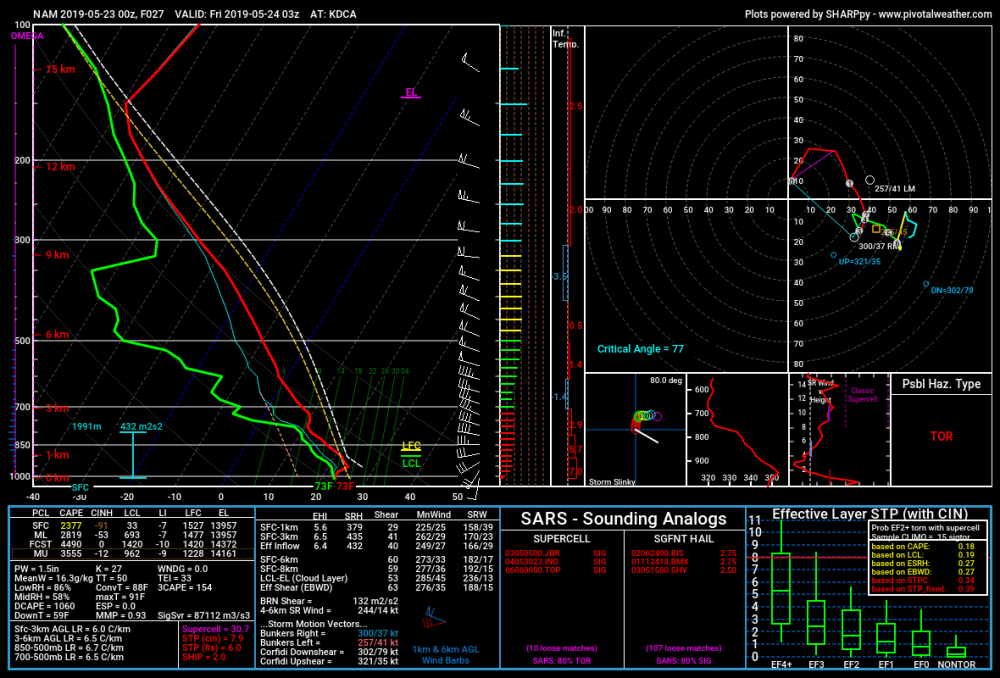
Another view of the sounding at DCA at 03z FRI per pivotalweather
-
00z NAM NEST decides to drive through some what would appear to be supercells around 20z to 21z... then brings a pretty decent line south from PA as a finale around 03z but its fragmenting around DC at that time
-
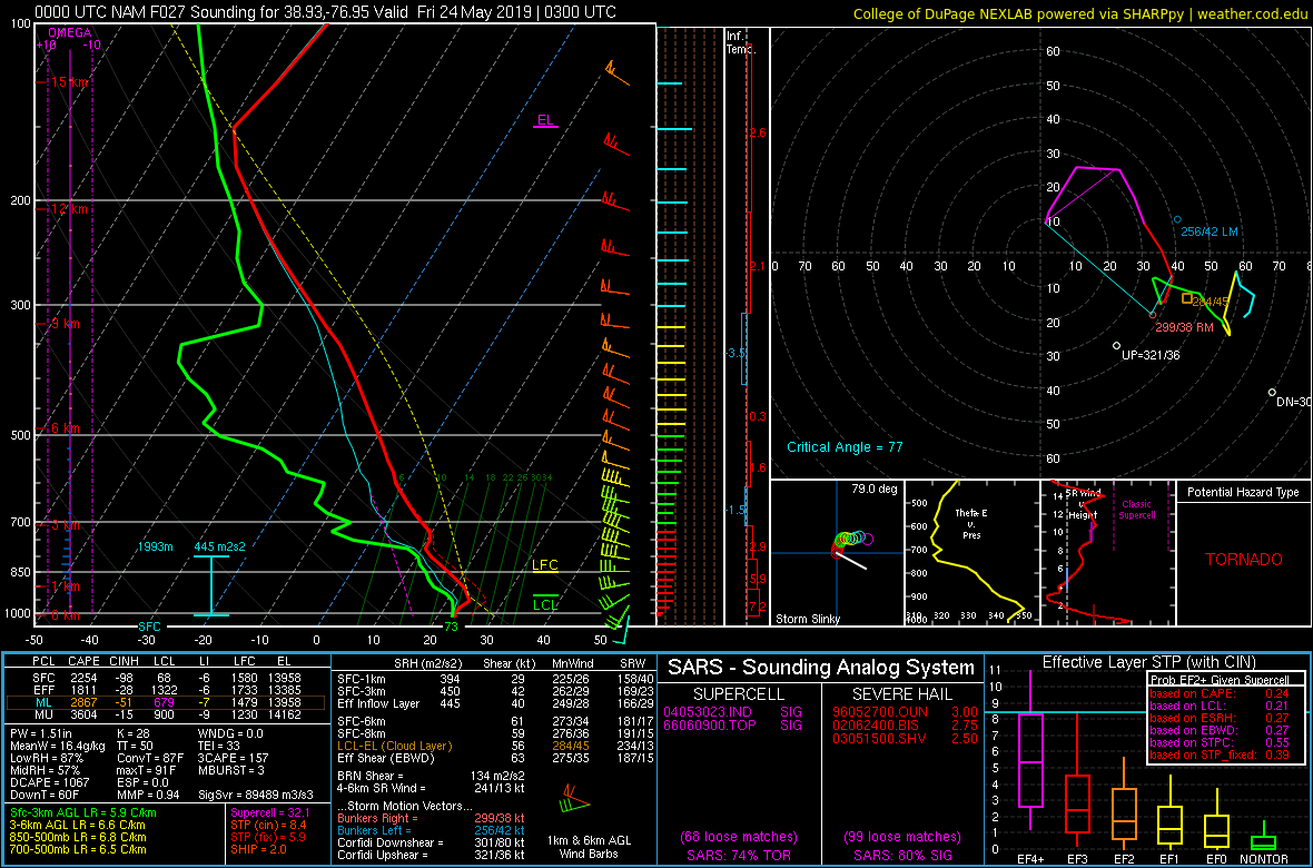
Oh hai... sounding around DCA at 03z FRI per the 00z NAM

-
00z NAM sim radar brings some nastiness for the evening commute from BWI to DCA to near EZF at 21z
-
Ok... those are some disturbing soundings the 00z NAM is tossing out at 00z and 03z FRI at KIAD... 03z FRI at KBWI and KDCA... Yes, just a sounding, but you don't see those types of soundings around here very often Yes, doesn't guarantee we see severe. But still... wow @Kmlwx @high risk
-

2019 Short/Medium Range Severe Weather Thread
yoda replied to snowlover2's topic in Lakes/Ohio Valley
Tornado Warning in NE MO for Marion and Shelby counties