

southmdwatcher
-
Posts
1,023 -
Joined
-
Last visited
Content Type
Profiles
Blogs
Forums
American Weather
Media Demo
Store
Gallery
Everything posted by southmdwatcher
-
Severe storms for the at least parts of the region instead of the chase for snow. Sorry but that is what the models are yelling. Hope we get the mid to late March Hail Mary snow event.
-
2023 Mid-Atlantic Severe Wx Thread (General Discussion)
southmdwatcher replied to Kmlwx's topic in Mid Atlantic
This topic will get much more active this week after we let go of the snow chase.- 2,785 replies
-
- 1
-

-
- severe
- thunderstorms
- (and 3 more)
-
Jan 31 - Feb 1 Snow/Sleet/Misery Obs & Disco
southmdwatcher replied to NorthArlington101's topic in Mid Atlantic
0.4" Avoided the shutout! -
December 22-23, 2022: Warm Rain to Arctic Chill
southmdwatcher replied to WxUSAF's topic in Mid Atlantic
28/25 Much colder than the last busted event. -
Rain total of 2.42" for this event
-
It's gonna rain tomorrow in DC Metro and we have closings and delays already. This is soft. Rant done. Bring on some real Winter weather next week.
-
Wow, hope we never have to do another March 1984/April 16 2011 Carolina's Outbreak event.........
-
This event looks like there could be some significant tornadoes. On another note, severe outbreaks that crossover to multiple regional subforums, have had difficulties. In the older forum, the Central/Western states took it upon themselves to have threads for any event west of the Appalachians.
-
TS Nicole Impact Thread for Friday into Saturday
southmdwatcher replied to yoda's topic in Mid Atlantic
The Tornado Watch was suppose to expire at 3pm and the local extension into southern MD didn't mention anything about extending the time. Instability seems to be at or higher than forecasted this morning. What is the SPC/local NWS doing? -
TS Nicole Impact Thread for Friday into Saturday
southmdwatcher replied to yoda's topic in Mid Atlantic
Tornado watch has been expanded into Charles and St Mary's Counties in Maryland -
So how difficult is it to do a lottery drawing???
-
Major November Outbreak Possible
southmdwatcher replied to Tallis Rockwell's topic in Central/Western States
No split, the structure is improving as it heads northeast from Carrollton to Plano -
Major November Outbreak Possible
southmdwatcher replied to Tallis Rockwell's topic in Central/Western States
However, that storm looks to be splitting. -
Major November Outbreak Possible
southmdwatcher replied to Tallis Rockwell's topic in Central/Western States
I have GRLevel2 Analyst 3.0 and the Tarrant storm doesn't yet look dangerous, as per a producing tornado issue. -
36
-
Rain and 46 degrees. Beautiful for early October.
-
2022 Mid-Atlantic Severe Wx Thread (General Discussion Etc)
southmdwatcher replied to Kmlwx's topic in Mid Atlantic
Tornado warning for the storm crossing the river into Charles County. -
2022 Mid-Atlantic Severe Wx Thread (General Discussion Etc)
southmdwatcher replied to Kmlwx's topic in Mid Atlantic
Video might be private or only available to his friends. Can not see it. -
2022 Mid-Atlantic Severe Wx Thread (General Discussion Etc)
southmdwatcher replied to Kmlwx's topic in Mid Atlantic
The storm near Culpeper needs to be watched. Now severe warned. -
Radar is aiming this first batch crossing the mountains toward southern MD/Northern Neck area.
-
2022 Mid-Atlantic Severe Wx Thread (General Discussion Etc)
southmdwatcher replied to Kmlwx's topic in Mid Atlantic
So this is going to be a southern MD/central VA event??.......well at least most of us have relatively dry ground -
2022 Mid-Atlantic Severe Wx Thread (General Discussion Etc)
southmdwatcher replied to Kmlwx's topic in Mid Atlantic
3 to 5 inch plus jackpots along Sligo Creek and the Little Patuxent River would be problematic -
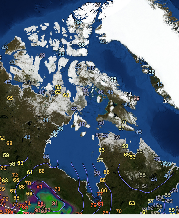
As per GR Earth the current temperatures in Central and Northern Canada
-
2022 Mid-Atlantic Severe Wx Thread (General Discussion Etc)
southmdwatcher replied to Kmlwx's topic in Mid Atlantic
Central PA supercell with the tornado warning has a BWER -
2022 Mid-Atlantic Severe Wx Thread (General Discussion Etc)
southmdwatcher replied to Kmlwx's topic in Mid Atlantic
We might be too far north or east to receive the storms forming out in Ohio and West Virginia. However, at least one of yesterday's SPC Convective outlook discussions, mentioned that the shortwave coming out of the Ohio Valley today and crossing over the Appalachians would produce some strong to severe storms well into the night for some portion of the Mid Atlantic region. Probably going to be a Richmond target.


