wxsniss
-
Posts
5,812 -
Joined
-
Last visited
Content Type
Profiles
Blogs
Forums
American Weather
Media Demo
Store
Gallery
Everything posted by wxsniss
-
First Legit Storm Potential of the Season Upon Us
wxsniss replied to 40/70 Benchmark's topic in New England
Euro AI stable 12z-18z-0z, just outside BM, widespread advisory -
First Legit Storm Potential of the Season Upon Us
wxsniss replied to 40/70 Benchmark's topic in New England
Lagging vorticity I was referring to was here... this could be feedback from the line of convection sweeping off southeast coast, I'm not sure as 6z GFS hinted at this too, but it disrupts much better cyclogenesis. Otherwise, we'd have a huge hit. -
First Legit Storm Potential of the Season Upon Us
wxsniss replied to 40/70 Benchmark's topic in New England
CMC 0z ~100-150 mile shift northwest over 12z... So far 0z major league guidance is 2/2 with a substantial hit -
First Legit Storm Potential of the Season Upon Us
wxsniss replied to 40/70 Benchmark's topic in New England
Yeah there's some lagging vorticity at 0z (? feedback with the line of convection sweeping off southeast coast), so cyclogenesis not as clean as 12z This verbatim solution less important than adding support for a subtantial SNE hit, 12z was not just a fluke GFS run -
First Legit Storm Potential of the Season Upon Us
wxsniss replied to 40/70 Benchmark's topic in New England
Definite improvement over 18z, thru 90h more similar to 12z with shortwave digging over Georgia -
January 2026 regional war/obs/disco thread
wxsniss replied to Baroclinic Zone's topic in New England
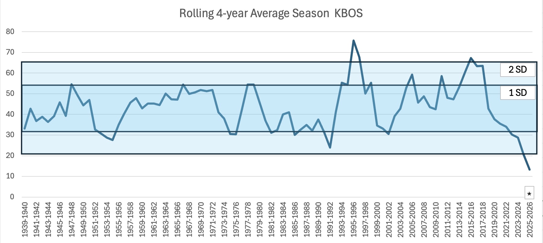
I'm in awe of the absolute clinic (interference and otherwise) by which SNE is missing significant snowfall, especially now in a BN cold stretch... For 15-16th and 18-19th in particular, strength of the vort on guidance a few days ago seemed like it would overcome any inteference issues to at least graze (15-16th) or cut (18-19th) A corollary: there are many more routes to having no event than there are for an event to materialize. I did this last year and was curious how it extrapolates this year... I charted 4-year rolling average snowfall at KBOS. Obviously 2025-2026 is not over, so for February and March I just used historic means (* indicates extrapolation from historic means for those 2 months). Look how off the charts this 4 year stretch has been... well below 2 standard deviations: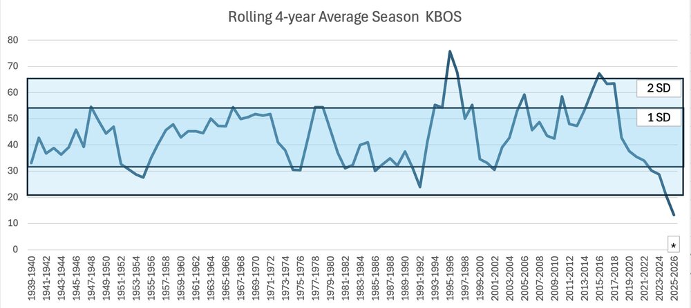
-
January 2026 regional war/obs/disco thread
wxsniss replied to Baroclinic Zone's topic in New England
Just catching up, good analysis all, great blog post Ray To add to all the flies in the ointment, I think the ULL over St. Lawrence River is hindering trough from tilting more negative, scoots this east just as it looks ready to explode. Diminish that and we’d have a huge hit on this 0z GFS. -
January 2026 regional war/obs/disco thread
wxsniss replied to Baroclinic Zone's topic in New England
Agree, best look in weeks... Lots of chefs in kitchen in a more favorable longwave pattern = potential, even if there is interference. At moment (and will obviously evolve this far out), EPS and EPS-AI hinting at a SNE grazer 16th followed by at least CNE/NNE hit 18th, but tons of scatter around those focal points with huge range in ceiling as we're seeing seeing on OP runs. I too am hoping to at least get the 6" monkey off our back, nearing 4 years now... and in the shorter term, let's get <32F by kickoff Sunday. -
January 2026 regional war/obs/disco thread
wxsniss replied to Baroclinic Zone's topic in New England
Great snow growth and grass whitening now in Boston Fenway area... And forecasts definitely busted a few degrees too warm this morning with continuing northerly drain in place As much as we continue to be starved for a meaty storm, at least this winter has given decent vibes with persistent cold and some white -
January 2026 regional war/obs/disco thread
wxsniss replied to Baroclinic Zone's topic in New England
https://xmacis.rcc-acis.org/ Specifically for KBOS (noting the unrepresentative wastewater facility caveats): 1936-37 9.0" 2011-12 9.3" 2023-24 9.8" 2025-26 5.0" to date Mean 42.2" -
Landed in Logan at 5:45am this morning… one of the most turbulent landings I’ve ever experienced. Looks like KBOS 59 mph gust. Multiple people throwing up before even we got to gate. Took me hours to settle my nausea. Missed the wounded duck storm… congrats to the region especially Connecticut and south shore areas.

-
December 14th - Snow showers or Plowable snow?
wxsniss replied to Sey-Mour Snow's topic in New England
18z AI-GFS (I have no idea if this is worth anything) is also ticking better than 12z -
December 14th - Snow showers or Plowable snow?
wxsniss replied to Sey-Mour Snow's topic in New England
If there's any takeaway from 18z suite, it's that this is not continuing to slip away into nothing (which was a distinct possibility on yesterday's guidance). It will be meager, but there will be accumulation. -
December 14th - Snow showers or Plowable snow?
wxsniss replied to Sey-Mour Snow's topic in New England
On this 18z NAM: some decent fronto scrapes the south coast... could see upwards of 3-5" right at the water if that occurs. Let's hold or continue these ticks in the next 12 hours... -
December 14th - Snow showers or Plowable snow?
wxsniss replied to Sey-Mour Snow's topic in New England
Yeah it's been a tough stretch for the region and this hobby. I posted last night... I remember the forum days of all-hands-on-deck war-room analysis for an impending KU, and now I'm micro-dissecting 1-2" vs. 2-3". We're famished for a region-wide larger event. Dec 20 2024 was the last positive bust for MBY (Boston suburbs) in years, and it was ~5.5". But easy to forget (maybe because the unseasonal cold) that it's very early and there's lots of winter to go. -
December 14th - Snow showers or Plowable snow?
wxsniss replied to Sey-Mour Snow's topic in New England
Box update As noted above, upside potential at this point IF the vort comes in stronger, could add 1-2" south and east zones, with maybe spots 4-5" total in outer Cape... -
December 14th - Snow showers or Plowable snow?
wxsniss replied to Sey-Mour Snow's topic in New England
Do you know how often the AIFS is re-trained? Would be amazing if in fact it gets better over the course of each event and each idiosyncratic setup. I came across this indicating an updated training schedule, but does not detail: https://arxiv.org/abs/2509.18994 (before I get misconstrued... I would hate losing the joy and suspense of forecasting to a perfect AI) -
Brace yourselves... Let's at least get some Foxboro snow mojo in the air Sunday
-
18z NAM was an example... on that run, more energy was able to compensate a little for the worse tilt and southeast squash To echo what CoastalWx and others have said... I remember the occasions, felt like a few times every season, when we were micro-analyzing such details with huge stakes on the eve of classic KUs. Now the stakes are a few inches and it's tiring. 0z Euro continued to tick the trough more positive and outcome more southeast... maybe 1-3" south coast, 3-4" outer Cape. 0z AIFS a hair better.
-
Not liking NAM trend at 18z, fwiw... 18z Saturday/0z Sunday is a key litmus I've been using on all guidance... all about pin-the-PV-center-on-the-lake... the further northwest that lobe center is, the better the downstream heights and tilt of our trough for our storm a day later: Over Lake Superior, high-end advisory. East of Lake Huron, it's a scraper.
-
Maybe the most negative steady trend today is both Euro-AIFS and EPS incrementally pulling away for 4 cycles since 6z today
-
0z EC: can see the worse outcome well before... at 72h 0z Sunday the PV center ticked slightly east over Lake Huron instead of Lake Michigan... that slight tick is enough to smush heights downstream and keep the trough more positive... Models are vacillating between SNE graze vs. 1-3/2-5... (and though hard to explain, it does strangely seem to correlate with 6z/18z vs. 0z/12z). Probably won't lock in for another 24 hours or so. I'm still favoring at least advisory in southeast areas.
-
Definitely better tilt, orientation of TPV, and upstream ridging by 0z Sunday compared to EC 0z... at moment a light event for southeast areas, but just minor tweaks will get significant improvement at surface on future runs
-
vs. 6z, EC significantly improved western ridge, not sure energy will dig and tilt enough to deliver on this specific run, but 14th a definite contender
-
Always a thrill to see opening best rates of the season, though only for about 3 minutes… We’ll have our chances… this alone looks like it should bring much better results at surface than it actually has, and can tweak significantly better with time: