wxsniss
-
Posts
5,810 -
Joined
-
Last visited
Content Type
Profiles
Blogs
Forums
American Weather
Media Demo
Store
Gallery
Everything posted by wxsniss
-
Possible coastal storm centered on Feb 1 2026.
wxsniss replied to Typhoon Tip's topic in New England
Others have commented on this, but it's illustrated well on this last NAM 12z (worse) vs. 6z (better)... The distribution / momentum of lumps of vorticity has a huge impact on the structure / tilt / timing of the trough and where our storm forms and ejects. On the NAM, if you look specifically at 6z Saturday timepoint at the energy over MO / IN / IA, 12z comes in like a flat swinging pendulum, whereas 6z run already has curvature in the stream allowing the ULL to close off further west. Same thing underlying improvements in the EC over past 4 cycles... compare 6z going back 4 cycles and look how it's trended better with that curvature at 6z Saturday: -
Possible coastal storm centered on Feb 1 2026.
wxsniss replied to Typhoon Tip's topic in New England
Surprised no one commented on full moon goon Feb 1-2 Too much uncertainty. Sounds like a cop out but I'd wait until at least Thurs 0z. -
What is this beast All PVA from H5 vort rounding trough?
-
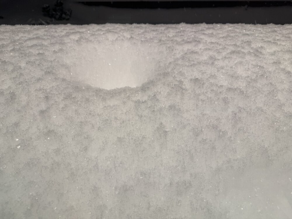
Unreal dendrites this is SO beautiful This storm had character Accumulation around a light:
-
Best rates of storm in Boston past 30 min We would’ve easily hit 30 with these dendrites yesterday Shoveled, reaccumulated 1” in 30 min
-
Sheer beauty out there… snow covered roads, massive piles, huge dendrites falling and rapidly accumulating. Another 2 inches for east areas at least.
-
Some jet assist along with this PVA?
-
Sorry not fresh, but wanted to add to thread for legacy / archival purposes... I thought this was a nice bit from the Box AFD last night detailing the storm. I'm still not sure why snowgrowth wasn't as good as many (including this AFD) expected... but with Cocorahs having generally 1.4-1.7 qpf / snow totals 15-20" (@Ginx snewx's call all week) with areas 20"+ in the expected north shore and Worcester hills... seems like SLRs ~10-12:1? Still achieved 1-1.5" / hr rates for almost entire duration. KEY MESSAGE 1...Major winter storm continues this evening and overnight. Difficult to impossible travel conditions persist through 12-2am with 1-3" per hour snowfall rates. After a bit of an early start, snowfall rates have increased to 1 inch per hour across much of the CWA this afternoon. These dangerous travel conditions continue well into the overnight as low pressure deepens offshore helping to increase mid level frontogenesis. The bulk of the snow falls through about 06z with gradual improvement into Monday morning as a dry slot works its way into the region. Storm totals are still holding steady as of the 18z update with totals expected to be in the 12"-18" range across the majority of southern New England, with 8"-12" expected on the Cape, Islands, and immediate southern coast. The higher elevations and northeastern MA will likely see 18"-24" for much of the 495 corridor including the Boston metro area. Coastal low takes shape off the Del Marva Peninsula this afternoon helping to further increase mid-level frontogenesis. In response, a deep and robust layer of lift will extend through much of the column including the dendritic growth zone (DGZ). BUFKIT soundings even show the potential for 2 favorable layers for dendritic growth, one in the mid to upper levels, and another closer to the surface with the deep and substantial near surface cold pool. Attention turns from mid level frontogenesis to lower level frontogenesis (925- 850mb) as a steep low level temperature gradient associated with an incoming coastal front approaches from the south. Coastal front initially races north across the ocean then slows to a crawl this evening as it encounters the wedge of low level cold air on land. Warm front aloft still continues north overnight, so expecting +SN to slowly transition to heavy sleet along the south coast and move inland between 00-05z Furthest inland extent looks to be along west to east corridor extending from Providence RI to Plymouth MA. In these locations the mid level warm nose increases to +1-2C. Perhaps a bit more exciting for us weather lovers is the non-zero chance for +TSSN as the mid levels warm enough for some elevated instability this evening into the overnight. Northeasterly LLJ increases to 30-40kts this evening as the low center passes just S of Nantucket. Thus, could see a period of gusty winds and blowing snow especially over the southern waters, Cape and Islands. HREF blizzard probs remain around 20%-30%, between 22 and 05z. The limiting factors for blizzard conditions along the south coast will be sleet and lower snow ratios as well as the short lived nature of the gustiest winds. Further inland, the mid level warm front stops short of changing the precip type to sleet and instead brings a lower ratio snow that that will help to cap totals between 12 and 18 inches for much of the interior. Impressive temperature gradient develops overnight with surface temps rising to near 32 as far inland as PVD but staying in the lower teens at ORH on the other side of the surface warm front! Prolific snow winds down from SW to NE as a mid level dry slot pushes into southern New England as 500-700mb RH values fall to 40- 60%. RH values like these are hostile to snow crystal growth and instead favor a period of "snizzle" or flurries. Any lingering snow eventually tapers to light flurries. Last hold out for light to moderate snow will be northeastern Massachusetts as northeasterly flow on Monday will allow for ocean-driven snow showers to persist into Monday afternoon. The next key message will better focus on Monday`s snowfall.
-
Was thinking the same. I think we have a real shot at 20" total looking at radar, and from soundings at 0z we could get better snowgrowth than we had all day yesterday...
-
Any thoughts on snowgrowth issues yesterday (and maybe relatedly SLRs)? Looks like generally 1-1.5”/hr so decent rates anyway, but the flakes were small for almost entire event. Was the DGZ not optimally saturated? Best omega above/below DGZ? CoCoRaHS seem generally 1.4-1.7 qpf so estimating maybe 10-12:1?
-
Remaining expected snowfall beginning 1am Monday:
-
Measured (compacted, not clearing) 15.25-15.5" at 1 am near Coolidge Corner in Brookline Beginning at 10am, that's ~1"/hr x 15 hrs, so accumulated decently despite the mediocre snowgrowth
-
Some of the highest in MA and CT: ...Worcester County... Holden 20.0 in 1219 AM 01/26 Trained Spotter Grafton 19.0 in 1219 AM 01/26 Trained Spotter 2 NE New Braintree 18.0 in 0925 PM 01/25 Trained Spotter Princeton 18.0 in 1054 PM 01/25 Trained Spotter Worcester AP 17.5 in 1157 PM 01/25 Official NWS Obs 1 NE Lunenburg 17.0 in 0946 PM 01/25 Amateur Radio 2 ENE Fitchburg 17.0 in 0951 PM 01/25 Amateur Radio ...Hartford County... 1 NNW Simsbury 18.0 in 0951 PM 01/25 Broadcast Media 1 SE Simsbury 18.0 in 1000 PM 01/25 Trained Spotter 1 NW Glastonbury 18.0 in 1030 PM 01/25 Amateur Radio West Hartford 17.0 in 0915 PM 01/25 Broadcast Media
-
...Suffolk County... 1 WNW Logan AP 16.7 in 1200 AM 01/26 Official NWS Obs 1 S Boston 15.0 in 0942 PM 01/25 Public 1 NNE Dorchester 14.1 in 1000 PM 01/25 Trained Spotter Logan AP 10.5 in 0700 PM 01/25 Official NWS Obs
-
I’m curious how the snowgrowth will be tomorrow… best lift looks lower than today, like 925-850 or 700 Interesting with all the discussion of 12-15:1 SLRs and good crosshair progged the initial few hours, the snowgrowth struggled…
-
So has the stupid iPhone weather app... has been saying Sleet here all afternoon
-
How's your snowgrowth been? Been a struggle so far here despite decent returns overhead
-
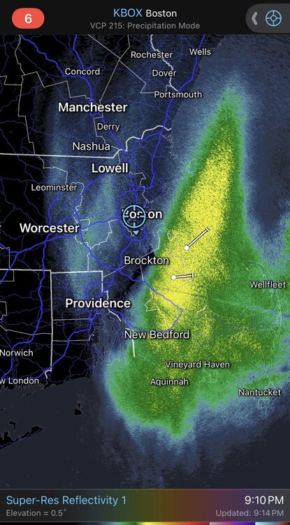
Matches well with velocity scans
-
Interesting in Brookline just still mostly arctic sand @weathafella @Henry's Weather and others in Boston metro curious what your snowgrowth has been
-
Yeah northeast MA / north shore area looks excellent for both portions of storm 6z NAM thermals about stable and continues the Monday top off thru midnight, might not even be a hiatus Monday morning
-
6z HRRR stable/ticked up:

-
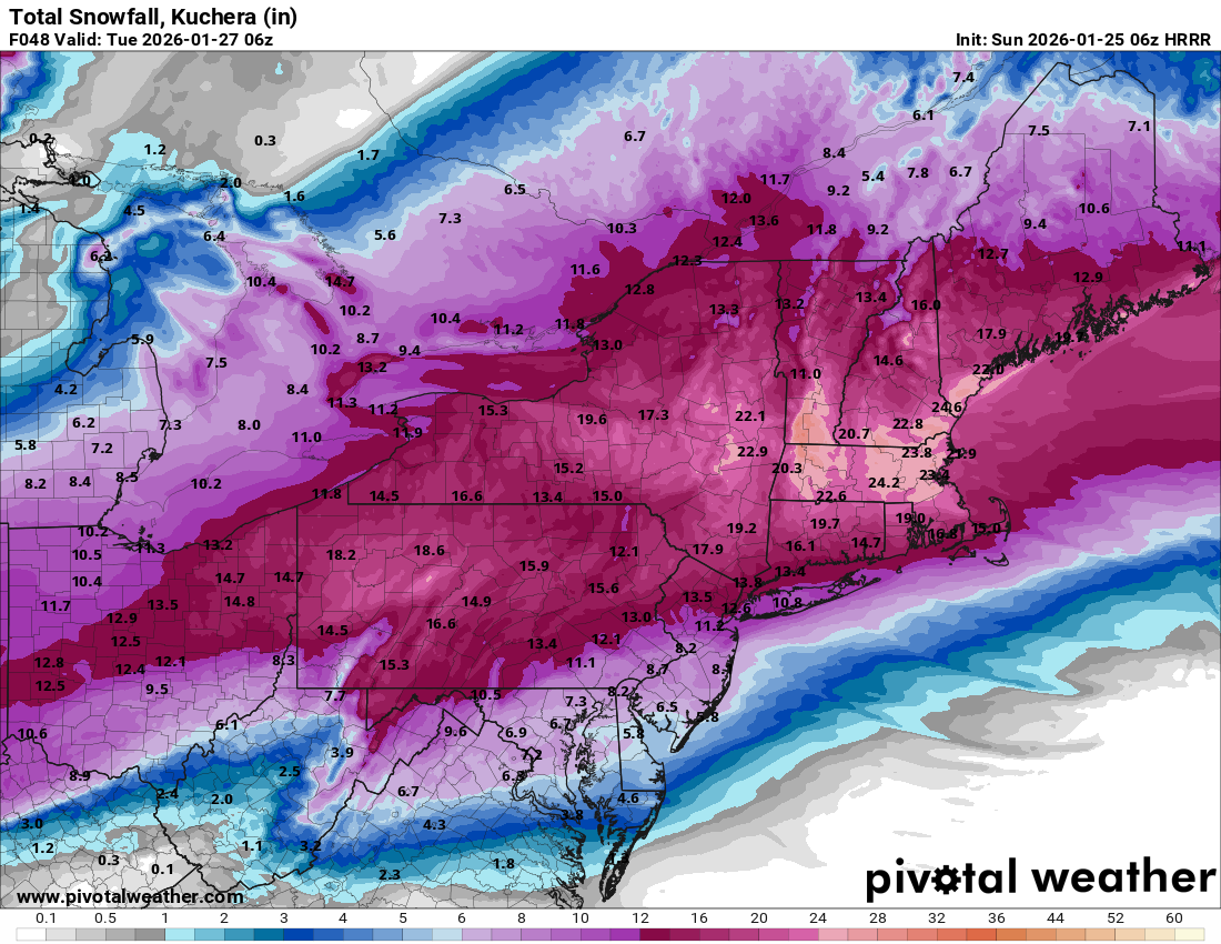
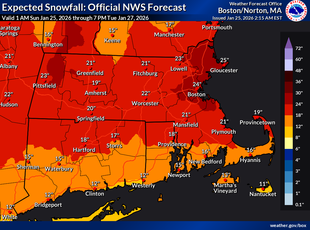
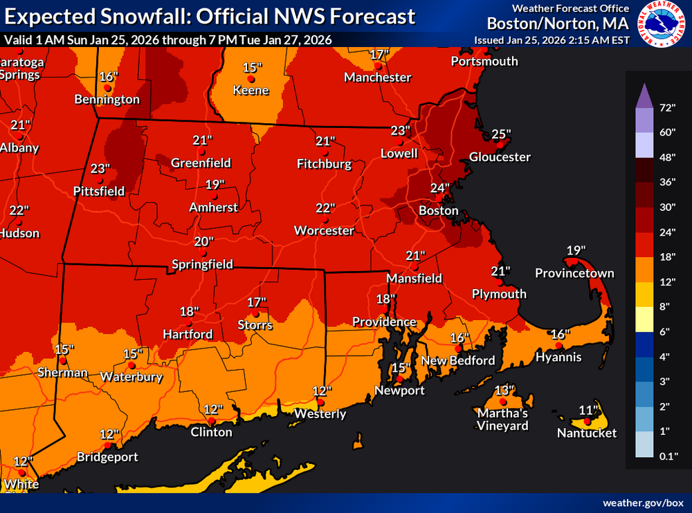
...or even the expected NWS snowfall map:
-
The Star Market on Commonwealth near BU. For some reason, there's a very strong correlation between impending screaming-media-hyped snowstorm and sold out bananas:
-
Pats in playoffs + impending major snowstorm… I'll echo Jerry's and other's sentiments... there's a palpable "night before" electricity we haven't felt for years. And having confidence only accelerate into the event is pretty amazing. Did grocery shopping tonight... the empty store shelves are honestly kind of silly, but maybe people are anticipating supply chain disruptions down south? In any case, loading groceries to the car and feeling the unabashed piercing cold on the eve of a huge snowstorm... New England winter is back. Our hobby, with all its rewards, is back. I know Sunday afternoon I'll be bouncing back and forth like a kid who never outgrew the thrill, relishing in the 2 hobbies. For those of us who have been yearning for something good in either realm for the past 4 years... finally, it's here.
-
Great map Ray. Best I've seen including the TV forecasts. I also think current NWS will be increased if 12z trends from today stand. I'm thinking areas of north shore have a shot at 18-24 especially if the east/northeast fetch Monday materializes