wxsniss
-
Posts
5,810 -
Joined
-
Last visited
Content Type
Profiles
Blogs
Forums
American Weather
Media Demo
Store
Gallery
Everything posted by wxsniss
-
Friday February 6 FROPA / WINDEX small event
wxsniss replied to HoarfrostHubb's topic in New England
Awesome hoping that swings east more than south -
Friday February 6 FROPA / WINDEX small event
wxsniss replied to HoarfrostHubb's topic in New England
I’m in Brookline just west of city, finally heavy snow gotta be 1-2”/hr at least Hoping we can benefit from the N-S orientation of this band whipping through city -
Friday February 6 FROPA / WINDEX small event
wxsniss replied to HoarfrostHubb's topic in New England
Some 35-40 dbz stuff approaching south shore -
Friday February 6 FROPA / WINDEX small event
wxsniss replied to HoarfrostHubb's topic in New England
@CoastalWx -
Friday February 6 FROPA / WINDEX small event
wxsniss replied to HoarfrostHubb's topic in New England
100% Good Harbor Beach should be epic right now… very jealous but I’ll take the great refresher Hopefully metro area fills in 12-3p -
Friday February 6 FROPA / WINDEX small event
wxsniss replied to HoarfrostHubb's topic in New England
Congrats @Ginx snewx@mattm4242folks RI/Orh/North shore getting absolutely crushed! Awesome event so many mesoscale processes HRRR has more filling in metrowest 12-3pm let’s hope we get better rates and growth -
Friday February 6 FROPA / WINDEX small event
wxsniss replied to HoarfrostHubb's topic in New England
RAPs 0z-1z-2z also ticked west -
Friday February 6 FROPA / WINDEX small event
wxsniss replied to HoarfrostHubb's topic in New England
A museum exhibit... I think I've seen something like this during a Dec 17 2020 WAA event:
-
Friday February 6 FROPA / WINDEX small event
wxsniss replied to HoarfrostHubb's topic in New England
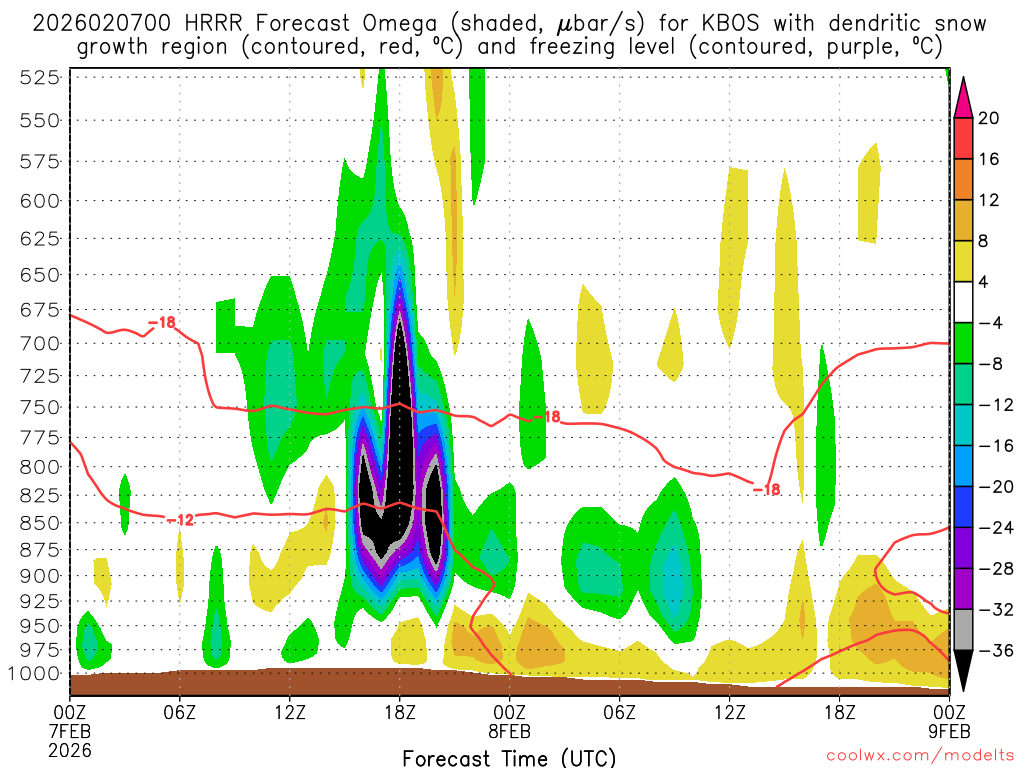
What's also amazing is it's not just a passing hour... like 15z-21z -
Friday February 6 FROPA / WINDEX small event
wxsniss replied to HoarfrostHubb's topic in New England
This is peak, but close to this for hours 15z-20z -
Friday February 6 FROPA / WINDEX small event
wxsniss replied to HoarfrostHubb's topic in New England
KBOS from 0z HRRR... -
Friday February 6 FROPA / WINDEX small event
wxsniss replied to HoarfrostHubb's topic in New England
Nice AFD, not a mundane setup: -AO and -NAO teleconnections yielding a very suppressed polar jet this period, with storm track well south of New England. However, this supports a potent, high latitude closed low to descend from James Bay into New England this weekend. This feature will be accompanied by an arctic front Sat, which will yield a complex snow event for SNE. This vigorous closed low induces cyclogenesis well southeast of the 40N/70W benchmark Sat. However, such strong forcing for ascent results in an inverted/Norlun trough from the offshore low extending northwest into SNE Sat. This will result in narrow bands of snow Sat moving west to east across CT/MA/RI. Model data reveals a combination of steep low level lapse rates (up to 9C/km in 0-2 km layer), deep saturated layer, strong convergence and at least modest omega in the snow growth region, will yield a 2- 4 hr period of moderate to perhaps heavy snow at times, from late Sat morning into the afternoon. The snow squall parameter ramps up rapidly between 18-22z across eastern MA Sat afternoon. 12z NAM bufkit for KBVY, indicates up to 20 u/bars of lift in the -10C to - 15C layer 15z-18z. This should yield favorable SLR and low vsbys. This is also supported by HREF offering 30-50% probs of hourly snowfall rates exceeding 1" and 20-30% for greater than 2" per hour, with these high rates focused across eastern MA westward into RI and the Worcester Hills. Duration of strong lift, deep saturation and steep low level lapse rates is brief (2-4 hr window) and this will limit accumulations to mainly 2 to 4 inches, with highest amounts across RI and central-eastern MA. This boundary becomes more enhanced as it enters eastern MA, with multiple models generating over 0.50 inches of qpf across Essex county, with some ocean effect enhancement contributing to the higher totals. In addition, the 13z NBM (v5.0) snow probs have 20- 30% probs of 8+ inches across Essex county, esp the Cape Ann area, and 50% prob of 6+ inches of snow. Given multiple models have strong low level convergence, steep low level lapse rates, a deep saturated layer and at least modest forcing for ascent in the snow growth region, will hoist a small winter storm watch area for Essex county. Snowfall projections here will be for 4-8", with even a low prob of isolated higher amounts pending the evolution of this mesoscale snow band associated with the inverted/Norlun trough. Keep in mind, these mesoscale snow bands are very difficult to forecast and this is a situation where snowfall amounts can vary greatly over short distance. Thus, continue to check back and monitor our updated forecast. For the remainder of coastal eastern MA, given the OES component, isolated amounts of up to 6 inches is possible. -
Friday February 6 FROPA / WINDEX small event
wxsniss replied to HoarfrostHubb's topic in New England
12z GFS and RGEM also like RI, soundings there looked good too They're probably accounting for ocean enhancement for higher confidence to warning amounts North Shore -
Friday February 6 FROPA / WINDEX small event
wxsniss replied to HoarfrostHubb's topic in New England
Box adjusted, appropriately imo... This is pretty close to HREF... some guidance had another max in south RI but not enough support: -
Friday February 6 FROPA / WINDEX small event
wxsniss replied to HoarfrostHubb's topic in New England
13z NBM... not sure how useful these are if at all... they were very good in the Jan 25-26 event. (EDIT in case people are wondering: these get released for 1z/7z/13z/19z... I assume because they incorporate a blend of the 0z/6z/12z/18z models) This is likely overdone, and not sure how appropriate a "blend" of models is for events that are heavily impacted by meso features for which models have lots of variation, but the trend has been steadily up. It's assuming mean SLRs 15-17:1 for the event.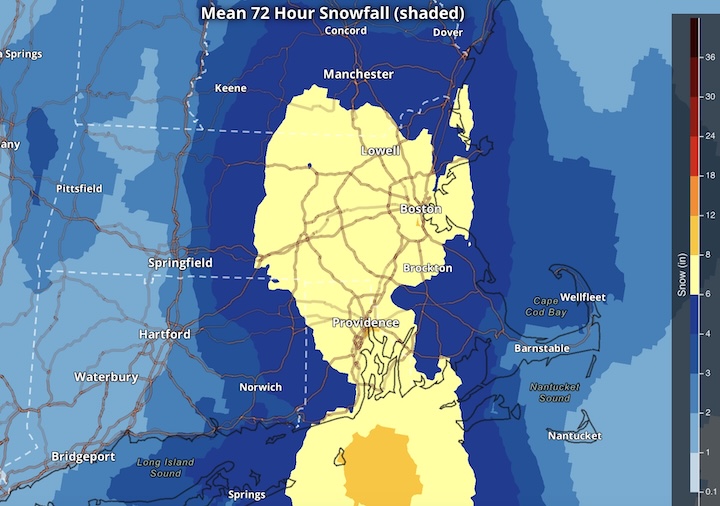
-
Friday February 6 FROPA / WINDEX small event
wxsniss replied to HoarfrostHubb's topic in New England
-
Friday February 6 FROPA / WINDEX small event
wxsniss replied to HoarfrostHubb's topic in New England
A prime nowcast setup, but there’s strong consensus at 12z on North Shore max (and a shot at warning) RGEM, GFS, NAMs, RRFS, …and this is the HREF: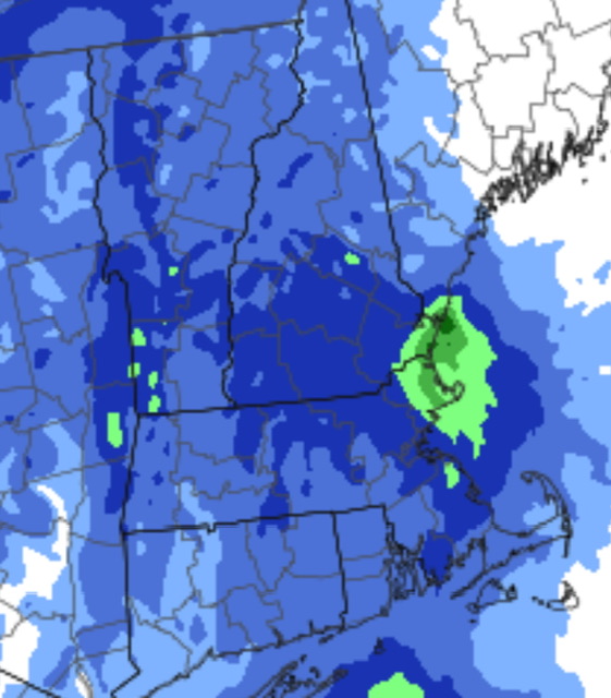
-
Friday February 6 FROPA / WINDEX small event
wxsniss replied to HoarfrostHubb's topic in New England
Rather dynamic pattern for Fri night into Sat as deep mid level trough amplifies across New Eng and eventually takes on negative tilt, with 700 mb low eventually developing south of New Eng Sat afternoon. Strong height falls developing off the coast will lead to cyclogenesis well offshore on Saturday, but given the strong upstream trough there will be an inverted trough that develops and extends across New Eng. Increasing forcing for ascent ahead of the trough and low level convergence with the inverted trough combined with deepening moisture plume with near saturation through the mid levels will result in widespread snow developing from late evening through Saturday. The snow should taper off in the afternoon in western New Eng behind the arctic front, while becoming more focused in eastern MA. Interesting set up as snow will be moving in from the west ahead of the trough, but hi-res guidance shows also bands of snow moving into eastern MA from the ocean later tonight through Sat from convergent NE flow ahead of the arctic front. The bands moving in from the ocean and the inverted trough are wildcards to the snow forecast. These inverted troughs are often associated with narrow mesoscale bands of enhanced snowfall where the low level convergence sets up. We also have potential for localized snow squalls along the arctic front. There are decent model signals given strong low level frontogenesis, relatively steep 0-3km lapse rates and some low level CAPE. Snow squall parameter is highlighted across eastern New Eng Sat afternoon. In addition, model soundings show very favorable snow growth for a few hours in eastern New Eng with 20-30 units of omega in the DGZ suggesting locally brief heavy snowfall rates of 1"+/hr within any enhanced snow bands. However, forecasting the exact location and axis of where these heavier snow bands is very challenging often leading to low confidence forecasts in location of potentially higher impact snowfall. This is a situation where snowfall amounts can vary greatly over short distances. -
Friday February 6 FROPA / WINDEX small event
wxsniss replied to HoarfrostHubb's topic in New England
-
Friday February 6 FROPA / WINDEX small event
wxsniss replied to HoarfrostHubb's topic in New England
19z NBM ticked up again -
Friday February 6 FROPA / WINDEX small event
wxsniss replied to HoarfrostHubb's topic in New England
NBM 13z Feb 5 output Not sure what this is worth and take guardedly for now (at least the distribution of highest amounts that will be pretty dependent on meso features), but it did pretty well with the Jan 25-26 storm... also notable that it has steadily ticked up the past 4 cycles: -
Possible coastal storm centered on Feb 1 2026.
wxsniss replied to Typhoon Tip's topic in New England
ngl, I (and I'm sure most here) check every NAM run for hint of a surprise, even though we've declared this dead. Without those runaway lows... you look at H5 and surface at 6z Sunday and think how can this miss a better hit on eastern areas. One thing that keeps me intrigued: yes the convection and buckshot lows further east are consistently run after run spoiling a hit, but where that convection and lows pop up is pretty inconsistent. -
Possible coastal storm centered on Feb 1 2026.
wxsniss replied to Typhoon Tip's topic in New England
Commented earlier today, here are some images... definitely some echoes of this on 18z Euro... models gonna struggle... EDIT: these images are from a NAM run before March 13, 2018: -
Possible coastal storm centered on Feb 1 2026.
wxsniss replied to Typhoon Tip's topic in New England
Just catching up... what a run I posted earlier this morning about resemblance to March 2018: Buckshot vorticity exiting Carolinas, spawning multiple lows, fujiwara of easternmost low swinging back NW towards benchmark, and consolidation of the entire gyre around benchmark yielding a big prolonged hit... This 18z Euro strongly resembles that handling -
Possible coastal storm centered on Feb 1 2026.
wxsniss replied to Typhoon Tip's topic in New England
Not saying this happens here but there is some resemblance: only from the perspective of the "shrapnel of vorticity" reminds me a bit of the March 13 2018 snowstorm... there too models struggled with multiple lows developing +/- chasing convection east +/- fujiwara of a low into New England... At the time I called it the "mogwai" effect of all these pieces of vorticity spawning small surface lows once they hit the water off the Carolinas, and models struggling to resolve how to handle Ultimately the stew of surface lows did gyrate close to BM with a big hit on much of region