

wxsniss
-
Posts
5,810 -
Joined
-
Last visited
Content Type
Profiles
Blogs
Forums
American Weather
Media Demo
Store
Gallery
Everything posted by wxsniss
-
Thanks for the quick advice guys I'll probably go with a Generac. I'm a little worried about footprint and available space closest to where our gas/electric intake and meters, but I'll get the consultation and see. It's easy to lose motivation and keep kicking the can, but I guess worth at least seeing if logistically possible and getting a quote.
-
Was thinking whole house ATS for simplicity Kids in multiple rooms, refrigerators, hot water, internet…
-
As this is the 3rd time this week / 5th time this year we’ve lost power in our neighborhood (powered by Eversource, outages all courtesy of low hanging wires and questionable pole infrastructure), I’m looking into a backup home generator Ideally connected to gas line and automatically turning on when power is out Any recommendations? I hear Kuhlman Electric ads for Generac all the time and seems good I figured this forum would have tons of experience with severe / blizzards TIA!
-
Lost power… 3rd time this week with non-severe winds Gonna put together a generator thread… Generac with Kuhlman Electric is constantly advertised on WEEI
-
Pretty healthy outflow just passed in Fenway area around 6:15
-
18z HRRR continues to target 21-23z for areas east of ORH for thicker smoke It's definitely ticking thicker outside Probably will be more like the milky haze we had Tuesday where you can actually look at the sun, and it gets deep red as it sets... not the apocalyptic yellow we had Wednesday where you can't even see the sun
-
Has a 40% penumbra look out there For areas east of Worcester, 17z HRRR has the worst ~21-23z, plume sweeping southward from NH
-
While obviously not real-time empirical data like GOES, HRRR has smoke guidance you can see on Pivotal to give you an estimate of current and future placement of the band Looks like thick smoke enters most of MA / SNH early afternoon 17-20z
-
Was thinking the same... or the yellow/greenish sky Plains tornado weather vibe. Pretty freakish look out there. Fluctuates in yellow tint, probably waves of thickness sweeping overhead At the moment, so thick I can't see the sun... will make a spectacular red sun on the horizon this evening if it thins out Smells unusual like a damp smoke
-
Hoisting the Sultan Signal: Heavy Rain Event July 5-7
wxsniss replied to WxWatcher007's topic in New England
This is impressive I thought guidance had most rainfall overnight into Tuesday morning… but by far best dynamics and rates of events now in EMA Gonna be widespread 2-3”+ east with this late surge Does have the feel of one of the storms we had last winter where we’re fully expecting a shank and then get destroyed late -
Fireworks 9pm at Glen Cove / Morgan Memorial park, LI… thoughts? NAMs HRRR are close developing storms into LI sound by 9-10pm
-
Now warned!
-
-
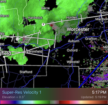
Decent velocity curl west of Worcester 5:15pm...
-
Very loud deep boom, 2:11pm heard in Natick MA Apparently heard across eastern MA and RI
-
Impressive little system, let’s get a critter like this in January MWN earlier this week and now:
-
As usual, model extremes were wrong... not a shutout like AI-GFS had for days, not a 3-day washout like EC / ens had a few days ago... converging towards a 1.5 of 3 days dry: completely dry Saturday (probably copy of today cloudy highs to 60s) worst day Sunday Monday looks dry 2nd half... Only reason I'm scrutinizing is a family event on Charles Saturday evening so thankful it looks dry
-
High stakes weekend... EPS/GEFS and EC are wettest models, but if anything maybe ticking drier AI-GFS/EC and GFS driest... 12z AI-GFS still a shutout until late Monday, but ticking less suppressed
-
Hope so. AI-GFS complete shutout vs. Euro is wet most of Sat night-Monday Box had been riding NBM, 50%+ chance showers all weekend...
-
Surprised by that number. Was about 3 min torrential and occasional pulses of horizontal windswept white curtains of rain, cars slowed down with hazards on, minor transient street flooding… decent but nothing photo-worthy. Didn’t see any tree damage.
-
Let's see if we warn inside 128 Hearing some rumbles near Fenway
-
Have an event on the Charles River near Boston Saturday evening... AI-GFS/ECs for a few days now have led the way keeping the ~1035 high in place east of us and suppressing precipitation southwest of SNE... hope it's correct!
-
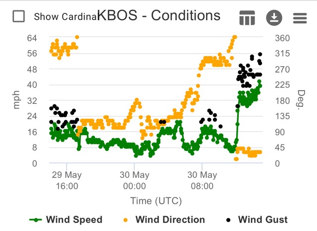
KBOS 170554Z 19029G54KT 62mph
-
At least for inside 128, not feeling a surprise >3" snow: DPs: Still an 850 tongue on 0z NAM 6z: Station: KBOS Latitude: 42.37 Longitude: -71.02 Elevation: 37.29 Press Height Temp Dewpt Dir Spd SFC 1023.6 37 0.5 0.1 51 13 M 1000.0 224 -0.8 -1.1 57 26 S 950.0 633 -1.7 -2.0 86 32 S 900.0 1065 -0.2 -0.5 87 22 M 850.0 1523 0.3 0.0 112 13 S 800.0 2009 -0.1 -0.4 147 9 S 750.0 2526 -0.4 -0.7 201 16 M 700.0 3077 -1.9 -2.3 229 25 9z: Press Height Temp Dewpt Dir Spd M 1000.0 214 -0.7 -9999.0 53 24 S 950.0 624 -0.4 -0.7 91 28 S 900.0 1057 -0.1 -0.4 96 23 M 850.0 1515 0.2 -0.1 123 13 S 800.0 2001 -0.5 -0.7 158 9 S 750.0 2517 -0.7 -1.0 239 16 M 700.0 3067 -2.2 -2.5 261 25
-
6z Friday on NAM: Station: KBOS Latitude: 42.37 Longitude: -71.02 Elevation: 37.36 Press Height Temp Dewpt Dir Spd SFC 1024.1 37 0.1 -0.4 51 13 M 1000.0 227 -1.0 -1.4 57 27 S 950.0 636 -2.9 -3.4 83 33 S 900.0 1066 -1.2 -1.6 96 25 M 850.0 1523 -0.0 -0.3 119 20 S 800.0 2008 -0.7 -1.0 139 20 S 750.0 2524 -1.1 -1.4 181 16 M 700.0 3073 -2.6 -3.1 219 22 S 650.0 3658 -5.1 -5.9 234 28 S 600.0 4284 -8.2 -9.2 243 35 S 550.0 4955 -11.7 -13.1 248 45 M 500.0 5679 -16.0 -17.8 251 54

