jaxjagman
-
Posts
9,165 -
Joined
-
Last visited
Content Type
Profiles
Blogs
Forums
American Weather
Media Demo
Store
Gallery
Everything posted by jaxjagman
-
Maybe you can get some better convevtion if you havent beem touched,dunno https://www.star.nesdis.noaa.gov/GOES/sector_band.php?sat=G19§or=smv&band=EXTENT3&length=24&dim=1&refresh=true
-
See what happens,there is a statinonary boundary into Southern KY,with A MCS diving down,shouldnt be severe now,just a drought buster
-
should get a good light show in the next few min,plenty of instability to work with
-
HORT TERM... (Rest of today through Tuesday) Issued at 1145 AM CDT Sun Jul 26 2026 There are 2 main concerns through Tuesday: heat and storms. A Heat Advisory was issued for our far western counties starting this afternoon, then expanding across most areas west of the Plateau starting Monday morning. The advisory will last until 8 PM Tuesday. The hot ridge over the Rockies and High Plains will bulge eastward, giving areas west of the Plateau highs in the mid 90s with heat index values well over 100. This results in Heat Risk levels reaching Major Risk level (3 out of 4). Although atmospheric moisture has decreased since yesterday with precipitable water values dropping below 2 inches, near surface moisture remains high with dew points in the 70s. Dew points can be expected to remain high through Tuesday and those PW values will climb again giving fuel for storms with heavy rainfall. So what are the details on storms? First of all, in this hot, steamy environment with some residual boundaries, we cannot rule out some storms any time, especially in the heat of the afternoon and evening. But, models are continuing to indicate an overnight MCS for tonight into early Monday morning. There are inconsistencies with track and intensity, but that is typical of this pattern. We know that very moist and unstable conditions will be present into the late night hours, so any storms that dive down from KY will have the potential to produce damaging winds and localized flash flooding. At this time, we are under a level 2 out of 5 severe risk north of I-40 with a level 1 out of 5 to the south. It would be wise to monitor updates through the evening and be prepared for possible severe storms in the overnight hours. Along with locally developing scattered storms, we cannot rule out another big storm cluster later Monday. Basically, we need to be watching to our north northwest through the next 48 hours. As we wrap up Tuesday, we will see a medium to high chance for storms ahead of a cold front. This Tuesday evening frontal passage will turn off the storms and drop temperatures to normal levels for the rest of the week.
-
Most seemingly is by a MCS into the night and early morning,the low level shear and lapse rates get better leading into later today,as to where this MCS goes which seems to be middle TN or east TN is still the question,Plenty of instability.HRR shows the KI-index of 44,would be quite a light show around Nashville,probably will back down later runs on that
-
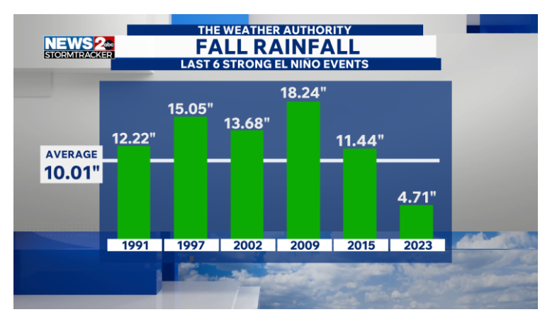
Most strong Ninos produce moisture,as to what happens this winter is surely uncertain,i still think NOV could dry out,severe Dec cold Jan and Feb,March are crap shots,but probably AN,thats just my opinion and surely might not be right
.png.253e59b0d58241a9e42fcf77569827df.png)
-

Spring/Summer 2026 Pattern Discussion Thread
jaxjagman replied to Carvers Gap's topic in Tennessee Valley
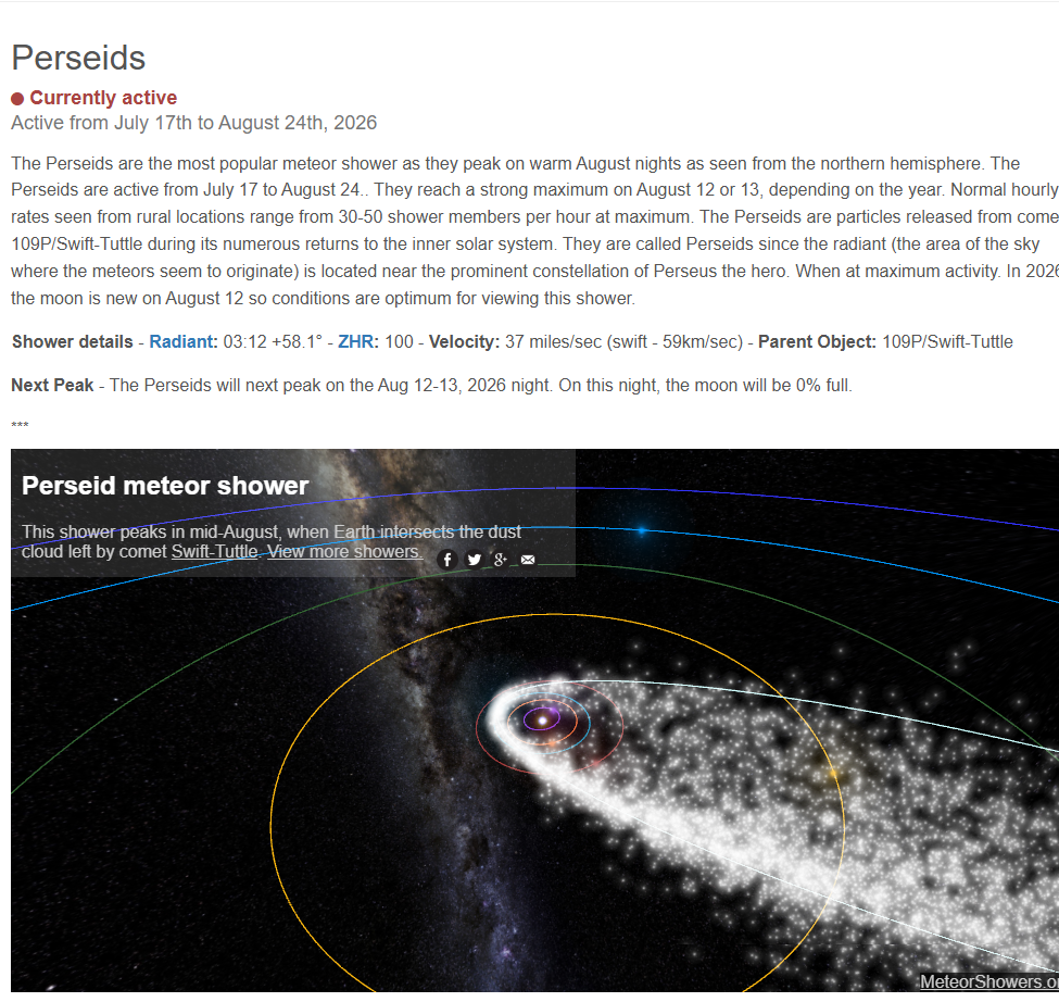
Maybe we will get a break with clouds upcoming,be cool to watch https://www.amsmeteors.org/meteor-showers/meteor-shower-calendar/#Perseids
-
ERW should help kick off a strong phoon headed towarsd East Asia,both the Euro and GFS today shows it headed towards Japan,but who knows where it goes right now,East China we could really warm up into Aug here
-
2026-2027 Super El Nino
jaxjagman replied to Stormchaserchuck1's topic in Weather Forecasting and Discussion
-
We moved from Brentwood to Franklin,we was surrounded by trees in Brentwood but we have a open skyline here,quite nice
-
Definite rotation around Vanleer
-
Spring/Summer 2026 Pattern Discussion Thread
jaxjagman replied to Carvers Gap's topic in Tennessee Valley
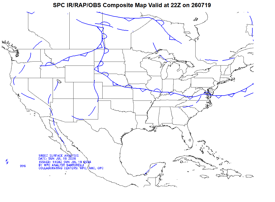
Finally getting some decent rain' Flash Flood Warning TNC037-149-187-200230- /O.NEW.KOHX.FF.W.0031.260720T0030Z-260720T0230Z/ /00000.0.ER.000000T0000Z.000000T0000Z.000000T0000Z.OO/ BULLETIN - EAS ACTIVATION REQUESTED Flash Flood Warning National Weather Service Nashville TN 730 PM CDT Sun Jul 19 2026 The National Weather Service in Nashville has issued a * Flash Flood Warning for... Southeastern Davidson County in middle Tennessee... Northwestern Rutherford County in middle Tennessee... Northeastern Williamson County in middle Tennessee... * Until 930 PM CDT. * At 730 PM CDT, Doppler radar indicated thunderstorms producing heavy rain across the warned area. Between 1.5 and 2 inches of rain have fallen. Additional rainfall amounts up to 1 inch are possible in the warned area. Flash flooding is ongoing or expected to begin shortly. -
Spring/Summer 2026 Pattern Discussion Thread
jaxjagman replied to Carvers Gap's topic in Tennessee Valley
Best storm in weeks is coming though,even knocked our power off brieftly -
Spring/Summer 2026 Pattern Discussion Thread
jaxjagman replied to Carvers Gap's topic in Tennessee Valley
Most of the rain upcoming seems like a boundary slipping down,who know who gets the rain but even so the MJO into the WH/EP isnt a rather dry solution,more unsettled in days ahead
-
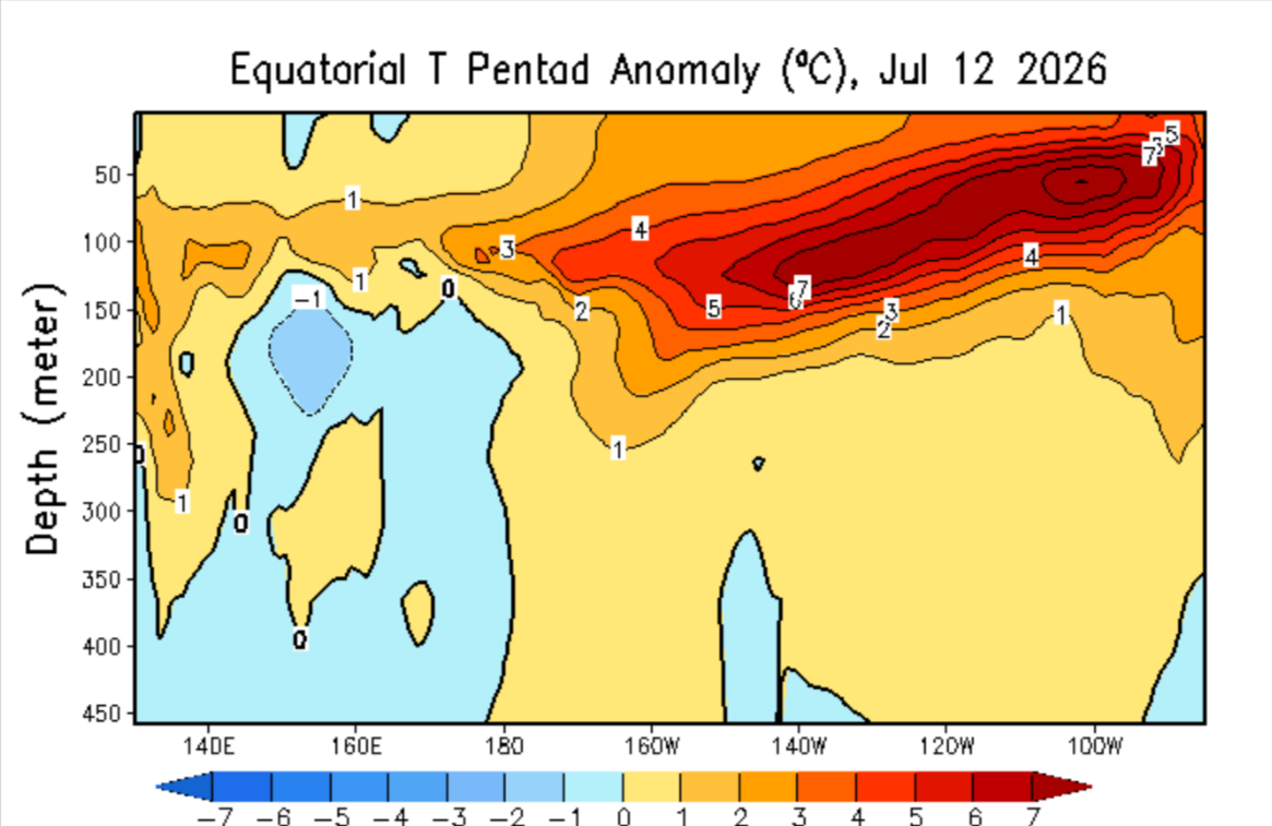
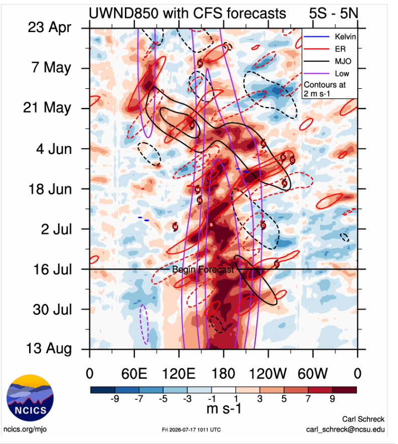
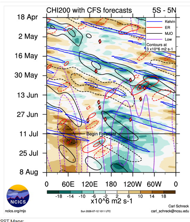
Last few days a bulleye has shown of +9C,while +8C is slowly expanding in the east,seemingly this is being caused by the MJO moving into the region along with a DWKW. We get into August the CFS shows another which could be the strongest yet WWB along the IDL,but thats to far out to trust ATM

-
Spring/Summer 2026 Pattern Discussion Thread
jaxjagman replied to Carvers Gap's topic in Tennessee Valley
How are yall even in a drought..lol We are having the same luck here like @ Dwagner is going through,i dont think we've gotten a inch the last 30 days while some parts are doing exceptional well. -
https://www.severe-weather.eu/global-weather/rare-atlantic-nina-joins-super-el-nino-atmospheric-shield-hurricane-season-winter-united-states-canada-fa/
-
2026-2027 Super El Nino
jaxjagman replied to Stormchaserchuck1's topic in Weather Forecasting and Discussion
Heres that article recently posted https://www.severe-weather.eu/global-weather/rare-atlantic-nina-joins-super-el-nino-atmospheric-shield-hurricane-season-winter-united-states-canada-fa/ -
2026-2027 Super El Nino
jaxjagman replied to Stormchaserchuck1's topic in Weather Forecasting and Discussion
Thats not going to ever happen with the EWB off SA.These winds are killing KW from getting that far east and the MJO should go back into the WP,if anything you might see an expansion from downwelling but 10-12/Not going to happen
-
Spring/Summer 2026 Pattern Discussion Thread
jaxjagman replied to Carvers Gap's topic in Tennessee Valley
Good for you guys in the east,this should help out with the drought anyways,. Ninos are always generally wet in Mid TN.in summer,kinda be surprised if anyone in TN has any drought as we head into fall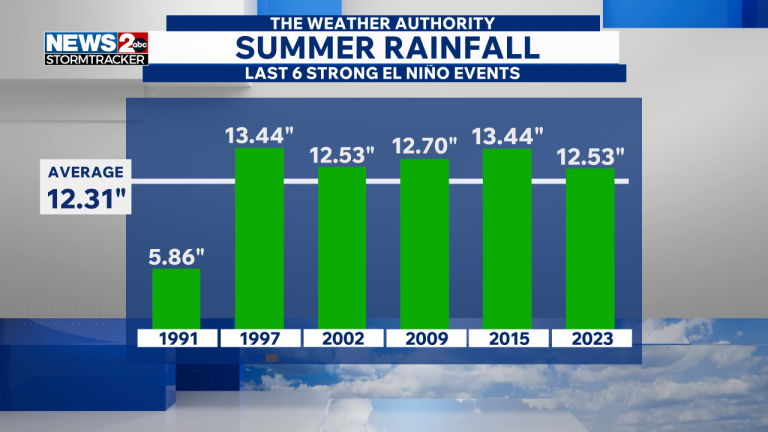
-
Spring/Summer 2026 Pattern Discussion Thread
jaxjagman replied to Carvers Gap's topic in Tennessee Valley
Least yall are getting something,boundary around Mid Tn with a weak surface low seemingly -
DWKW the next couple weeks could possibly expand or even rise those SST anoms from +8C IN the east
-
2026-2027 Super El Nino
jaxjagman replied to Stormchaserchuck1's topic in Weather Forecasting and Discussion
We had a -PDO in the strong NINO of 57-58,we just had some good North Atlantic blocking,it was quite cold in the TnValley,maybe Global warming is a player now which seems possible,but that was quite unusual when you see waterways in Mid Tn freeze up in J/F,it that happens agin who knows -
2026-2027 Super El Nino
jaxjagman replied to Stormchaserchuck1's topic in Weather Forecasting and Discussion
Actually if you go back to 57-58 it was quite cold after Dec,while NOV like you mentioned was BN,Dec was more severe,but J/F was really cold,if that happens again who know,plus March of 1958 had the blizzard in the east -
57-58 was quite unique.Nashville recorded the 6th lowest BP reading on record in Feb.Also into April had its 2nd strongest wind readings.There was the big blizzard in March in the east that dumped 2-3 feet along Conte.But it was so cold here that winter JAN/FEB it froze the waterways in MID TN.Plus we had the typical severe outbreak in Dec 57,with strong NINOS