

Terpeast
-
Posts
5,684 -
Joined
-
Last visited
Content Type
Profiles
Blogs
Forums
American Weather
Media Demo
Store
Gallery
Everything posted by Terpeast
-
January: Medium/ Long Range: May the Force be with Us....
Terpeast replied to Weather Will's topic in Mid Atlantic
Just spitballing based on gut feel, no real scientific reasoning. I think the best waa banding will occur just to the north of me. Hopefully I can stay within that band too -
Happy new year all!
-
January: Medium/ Long Range: May the Force be with Us....
Terpeast replied to Weather Will's topic in Mid Atlantic
Looking ahead, some ridging is trying to push into Alaska again, which would keep the EPO from going too positive.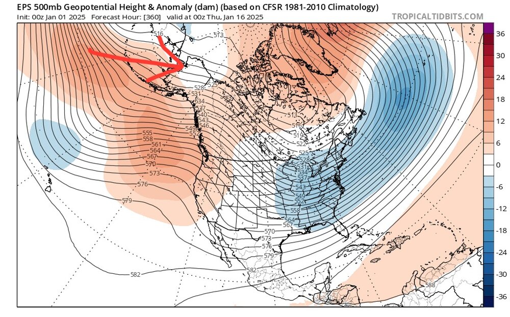
-
January: Medium/ Long Range: May the Force be with Us....
Terpeast replied to Weather Will's topic in Mid Atlantic
Nice set of 0z and 6z runs. The south trend needed to stop and it did. This is now within 5 days. Confidence is ticking higher. -
January: Medium/ Long Range: May the Force be with Us....
Terpeast replied to Weather Will's topic in Mid Atlantic
And btw, happy new year everyone! -
January: Medium/ Long Range: May the Force be with Us....
Terpeast replied to Weather Will's topic in Mid Atlantic
Ukie further south and bit slower -
January: Medium/ Long Range: May the Force be with Us....
Terpeast replied to Weather Will's topic in Mid Atlantic
So, here’s where we are at. 3 models tonight - icon, gfs, cmc - stopped the suppression trend and brought the storms back north. Bit weaker confluence, better wave spacing by slowing the storm down 6ish hours. -
January: Medium/ Long Range: May the Force be with Us....
Terpeast replied to Weather Will's topic in Mid Atlantic
Actually the models sped up this storm since early yesterday, and then now slowing it down a bit. -
January: Medium/ Long Range: May the Force be with Us....
Terpeast replied to Weather Will's topic in Mid Atlantic
CMC had us flirting with the mix line. This is as far north as we want it to go. -
January: Medium/ Long Range: May the Force be with Us....
Terpeast replied to Weather Will's topic in Mid Atlantic
I’ll take it. The south shift stopped and its back north per gfs. Probably some more wiggling to do, but starting to settle on the general track. Which is the kind of track we want. -
January: Medium/ Long Range: May the Force be with Us....
Terpeast replied to Weather Will's topic in Mid Atlantic
Confluence def more east -
January: Medium/ Long Range: May the Force be with Us....
Terpeast replied to Weather Will's topic in Mid Atlantic
Better, but careful. Don’t want to overcorrect -
January: Medium/ Long Range: May the Force be with Us....
Terpeast replied to Weather Will's topic in Mid Atlantic
And not much difference in the NE low -
January: Medium/ Long Range: May the Force be with Us....
Terpeast replied to Weather Will's topic in Mid Atlantic
Gfs is running. @stormtracker you still alive? -
January: Medium/ Long Range: May the Force be with Us....
Terpeast replied to Weather Will's topic in Mid Atlantic
Not surprisingly. We need better wave spacing -
January: Medium/ Long Range: May the Force be with Us....
Terpeast replied to Weather Will's topic in Mid Atlantic
We better stop the south trend tonight though -
January: Medium/ Long Range: May the Force be with Us....
Terpeast replied to Weather Will's topic in Mid Atlantic
Love that movie. Can’t watch it too many times -
January: Medium/ Long Range: May the Force be with Us....
Terpeast replied to Weather Will's topic in Mid Atlantic
On my second beer, victory Merry Monkey. We’ll see if I make it through the pbp tonight haha -
January: Medium/ Long Range: May the Force be with Us....
Terpeast replied to Weather Will's topic in Mid Atlantic
I’m gonna stay up just for @stormtracker’s pbp. It’s epic when done drunk -
0.38” per my new weather station imby
-
January: Medium/ Long Range: May the Force be with Us....
Terpeast replied to Weather Will's topic in Mid Atlantic
Larry Cosgrove -
January: Medium/ Long Range: May the Force be with Us....
Terpeast replied to Weather Will's topic in Mid Atlantic
Past 4 runs, GFS has been zig zagging between N and S. Maybe it's just trying to come in better focus. -
January: Medium/ Long Range: May the Force be with Us....
Terpeast replied to Weather Will's topic in Mid Atlantic
I think the ICON is in error because no other model closes off a tiny low off baja and lets it just sit and spin. I'd regard it as a one-off, but monitor closely. -
I think the cold being centered the W or SW is a good thing as opposed to it being right on top of us.
-
January: Medium/ Long Range: May the Force be with Us....
Terpeast replied to Weather Will's topic in Mid Atlantic
2902. Christmas present from wife


