

psuhoffman
-
Posts
27,419 -
Joined
-
Last visited
Content Type
Profiles
Blogs
Forums
American Weather
Media Demo
Store
Gallery
Everything posted by psuhoffman
-

GOOD CHANCE OF 1ST LIGHT SNOW EVENT VA / nw NC/ MD DEL MONDAY DEC 7
psuhoffman replied to DTWXRISK's topic in Mid Atlantic
Fixed -
Uh oh it’s so bad he broke character. 2020 has broken the reaper!!!
-
The EPS still shows a brief window around Dec 16-18 before the pac puke arrives if something can amplify before the cutter vacates the 50/50 region. After that looks ugly. Silver lining is the Atlantic side stays ok. Unlike last year there are hints, including signs of a SSW, that the NAM might not be a complete lost cause this year. The pac looks a mess. I kind of assumed that was coming. But last year the Atlantic side was hostile too. That’s a no hope situation. If we get some Atlantic side help this year we should get some opportunities. It will still be a struggle and a fight. Nothing will come easy. But it’s not hopeless like last year.
-
See my post above
-
I’m not touching policy. I don’t want to start a political fight! I was simply fact checking some statistical claims he made. I wasn’t advocating for or against anything you just said. Just didn’t want some false information floating around. People are free to draw whatever conclusions they want from the statistics...but the stats should be accurate at least.
-
@40westwx couple clarifications. 1. The US population increased by about 957,000 in 2019 not 6 million. Maybe you saw 6% which is the avg rate increase over the last 20 years and misinterpreted that. But the rate has been dropping steadily in recent years. 2. a relatively small change in the mortality % is really significant when applied to 329 million people! Your talking about hundreds of thousands of people with just a fraction of a % change. 3. deaths from heart disease are up not down. https://www.healthline.com/health-news/why-the-heart-attack-death-rate-has-doubled-during-covid-19 https://www.heart.org/en/news/2020/07/10/more-people-are-dying-during-the-pandemic-and-not-just-from-covid-19 4. One number in isolation doesn’t give a clear picture when dealing with an issue that has multiple variables. You need to control for all the variables. This could work either way. Deaths from things like heart disease have gone up due to people in some cases being reluctant to get treatment. But there is evidence some other death rates have gone down. Even though the % of accidents that are fatal has gone up die to wreck less driving on less crowded roads because the sheer volume of accidents is so down the overall mortality decreases. There are various other factors needed to be calculated. That could end up pushing the conclusion you infer in either direction but it can’t be known until it is done. I’ll let the expert statisticians who are paid to do that...do it before I draw conclusions.
-
GOOD CHANCE OF 1ST LIGHT SNOW EVENT VA / nw NC/ MD DEL MONDAY DEC 7
psuhoffman replied to DTWXRISK's topic in Mid Atlantic
Cool, my misunderstanding. Just want to make sure I know “the rules”. OSfan was being a bleep though. -
December 5-6, 2020 Storm Observations and Nowcast
psuhoffman replied to Baroclinic Zone's topic in New England
Told ya the dry slot wouldn’t make it to you. That band will start to dissipate over the next couple hours but upslope flow could keep you going for a while. -
December 5-6, 2020 Storm Observations and Nowcast
psuhoffman replied to Baroclinic Zone's topic in New England
We can get intense CCB banding down in MD too but it’s less frequent getting a storm to amplify enough that far south. Plus we can get some pretty good WAA front end thumps too if there is a deep cold layer dammed in. Obviously it happens way more frequently in New England. -
So you’re saying there are very fine people on both sides?
-
GOOD CHANCE OF 1ST LIGHT SNOW EVENT VA / nw NC/ MD DEL MONDAY DEC 7
psuhoffman replied to DTWXRISK's topic in Mid Atlantic
But if there is a storm thread do they still post in there or the storm thread? Maybe it was that way and I never noticed before. We’ve had forum dividing events though and melt downs by weenies whose feeling are hurt it’s not gonna snow on their house but I don’t remember (besides jokes) suggesting the part of the region getting snow needs to sequester themselves away so as not to hurt the feelings of those not getting snow. -
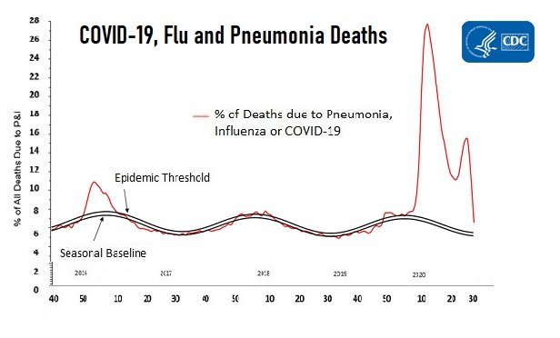
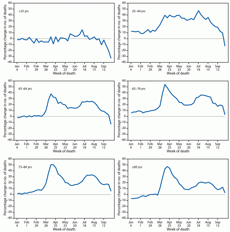
@mdhokie this is the mortality chart for 2020 from the October CDC update with covid broken down by age. You can see mortality has been running way above normal. The drop near the end is due to a lag in reporting. The second chart lumps all flu/pneumonia/covid deaths together which debunks the claim that flu or pneumonia deaths were being mis attributed. If so it’s funny how we suddenly had a pneumonia epidemic.
-
https://www.macrotrends.net/countries/USA/united-states/death-rate The site clearly specifies that 2020 does not include covid impacts. In searching for this source I also found references to the CDC releasing non covid mortality estimates. So putting 2+2 that chart is our 2020 projected mortality absent effects of covid. Which makes sense. But the way it was presented was misleading.
-
Very important to mention the data you cited does not include any covid data. That is our mortality rate excluding covid deaths.
-
That house needed more moderation
-
December 5-6, 2020 Storm Observations and Nowcast
psuhoffman replied to Baroclinic Zone's topic in New England
Oh definitely...but with a more typical temperature profile across eastern North America I also doubt you see that result either. Either way it was anomalous not something that should happen frequently, especially not deeper into winter. -
GOOD CHANCE OF 1ST LIGHT SNOW EVENT VA / nw NC/ MD DEL MONDAY DEC 7
psuhoffman replied to DTWXRISK's topic in Mid Atlantic
Don’t be a jerk. Yea this sub is dominated by the DC Balt corridor but that doesn’t mean the people in our region outside that zone can’t discuss their weather.- 346 replies
-
- 17
-

-

-
December 5-6, 2020 Storm Observations and Nowcast
psuhoffman replied to Baroclinic Zone's topic in New England
We’ve been in about as bad a pattern as possible all November and so the North American temp profile was torched. That’s not something that will happen often where you are, and especially not mid winter. -
December 5-6, 2020 Storm Observations and Nowcast
psuhoffman replied to Baroclinic Zone's topic in New England
Deer jumped out right in front of me on that road last trip up to Sugarloaf. -
December 5-6, 2020 Storm Observations and Nowcast
psuhoffman replied to Baroclinic Zone's topic in New England
From numerous spring ski trips up there, once you get north of the crest of the Presidential range and running NE in Maine...places with some elevation hold their snowpack pretty good all winter. They’re shielded a bit from the warmth there. -
December 5-6, 2020 Storm Observations and Nowcast
psuhoffman replied to Baroclinic Zone's topic in New England
I doubt the dry slot makes it to you. You should stay under banding until about 2-3am then it’s upslope after that. -
December 5-6, 2020 Storm Observations and Nowcast
psuhoffman replied to Baroclinic Zone's topic in New England
Yea...when it’s 31/32 at 1600 feet in northern NH under heavy precip...nuff said. -
December 5-6, 2020 Storm Observations and Nowcast
psuhoffman replied to Baroclinic Zone's topic in New England
I assume you are in one of the higher elevations in the area? -
December 5-6, 2020 Storm Observations and Nowcast
psuhoffman replied to Baroclinic Zone's topic in New England
It’s pretty awful for this time of year. The pattern now is ok but the record +NAM state and pac ridge combo in November left us void of any N American cold air source. I know I’m south of you but I’m on top of a ridge in a spot that normally gets crushed by marginal good track setups and despite a textbook h5 and surface track all I could manage is a few slush bombs mixing in during the heaviest rates. Everything had to go picture perfect for this to work even up there given there was no low level cold at all to work with. -
December 5-6, 2020 Storm Observations and Nowcast
psuhoffman replied to Baroclinic Zone's topic in New England
I think that’s a good spot


