

psuhoffman
-
Posts
27,419 -
Joined
-
Last visited
Content Type
Profiles
Blogs
Forums
American Weather
Media Demo
Store
Gallery
Everything posted by psuhoffman
-
That can get way in the weeds because people argue over the definitions. Is a miller B any storm that goes up west of the apps and jumps? Only northern stream systems that jump and develop. Some mix? Where does it go from A to B? Most storm jump somewhere. Actually all storms jump since pressure centers are always redeveloping. But those jumps are often minor. So when a gulf system gets into GA then jumps to off the Carolina coast we don’t say anything. When a storm jumps from Ohio to off VA that’s a bit more significant so it gets a different classification. I don’t really like to waste time arguing about definitions and terminology. So it just depends. Rule is the more STJ dominant the better. Further south the transfer and or phase the better! Closer to a miller A the better. But a pure miller A is rare. And even those rules aren’t 100% March 2013 we had a northern stream handoff that jumped so far south due to an Uber block that we got screwed and the heavier banding set up by Richmond. Everything is a matter of degrees. Everything depends on lots of variables. Even the perfect track depends on how mature and deep the low is and the thermal profile around it.
-
You are correct if it’s a pure northern stream dominant miller b. But there are A/B hybrids. If there is enough STJ involvement and the phase/transfer happens far enough south those can work. Right now this looks like a hybrid. Lots of STJ involvement. I think we have more of a chance here then with a pure miller B. But unless it’s a pure miller A there is always a risk the storm develops too late for us.
-

-
If P3 is an appetizer I’m gonna need some stretch pants
-
Naw that’s not how it’s gonna go. We’re going to be watching radar as the first BECS bears down. NWS zone says 50-60” in DC. 70”+ NW. 20 foot drifts. And just as the first flakes are about to fall Trump Nukes the storm so his flight to Maralago isn’t delayed.
-
Just read the discussion thread. Confused. Why aren’t there 500 posts about the weeklies, MJO and the strat right now?
-
Build the h5 pattern and the snow maps will come
-
Trends. Lot of time. Let’s see how this evolves. It’s a slight adjustment in boundary temperature from a big hit. Also a few times in recent years guidance showed something at range that didn’t align with the pattern. Each time they adjusted. The most recent was late January last year. There was a coastal threat that at range was a perfect track rain. I said that didn’t make sense with the pattern. In the end the storm stayed suppressed but it would have been cold enough. The guidance adjusted. It was one of the only realistic threats we had all winter. We just didn’t cash in but not due to temps. I’ll agree if it did go down that way it would be troubling. I don’t mind when bad patterns are bad. But if we start losing when everything is perfect that’s a bad sign for something worse then just a bad pattern behind our struggles. But my guess is if this progresses like that Gfs run it would be colder. Yea this
-
You assessing your posts now?
-
Monday would have to thread a needle. Thermals will be a problem. The spacing between systems and the angle of the front is problematic. If the front clears the storm likely stays south. If it doesn’t it’s warm. Very narrow window for frozen. Not impossible but unlikely imo. The threat after that though is looking better across all guidance and might be our first real good opportunity. Plenty of hits in all 3 ensembles. More importantly the idea is supported by the major teleconnections
-
Surface is scorched.
-
Yes except we aren’t chasing a day 16 fantasy. The NAO ridging has already begun to develop and by 72 hours we have a legit -AO/NAO that holds and even strengthens through the rest of the run on ALL guidance.
-
It’s the best look up top we’ve had in years...some ppl are just getting antsy because there isn’t a blizzard on the Gfs yet lol
-
If you can only have one and the other will we total garbage the pac is better. We have more snows from pac help and a disaster atl then the other way. However, that assumes both the epo and pna are hostile. The advantage of high latitude blocking in a Nina is if you get enough ridging into the western NAO and AO domain it’s going to apply pressure on the TPV to either retrograde west just enough to pop a pna ridge...the you have a +epo, +pna -AO/NAO which is a great snow pattern or you get the tpv to drop into the west and pop an epo ridge and get a -epo -pna -AO/NAO which is also good. It’s hard with a great looK up top for the pac to remain total garbage in both the epo and pna domains.
-
Yea. But my main take away is every run of every model is building a monster blocking regime. And at a time of year when that matters for some hints at the winter base state. But yea it would hurt bad if it went down that way. But I bet if this look lasts until prime climo it’s just a matter of time. What would hurt bad is if we waste this now then it flips before we get to the part of winter when we usually do take advantage of blocking. Awful. You can't afford to waste these big gulf systems. This isn't a Nino with a constant juicy stj. You gotta score now It hasn’t happened yet. It’s close. Only a small adjustment from a snowstorm. Let’s see. Yikes ya
-
Put a low to our northwest. Go counterclockwise around it. What direction would our wind flow be? I’m oversimplifying it but...it cuts off the cold air source.
-
Happy hour almost delivered. But a lakes low screws it up. We get a perfect track huge rainstorm. Unfortunately that’s not that uncommon for December. But that crap better not continue in Jan/Feb
-
The Xmas eve storm could end as some flurries
-
Or it could go down like the EPS control and the reaper will be busy. Suppressed, miller b split, huge suppressed storm just to our south, and the grand finale a perfect track perfect h5 huge rainstorm on Xmas eve as the cold gets too stale.
-
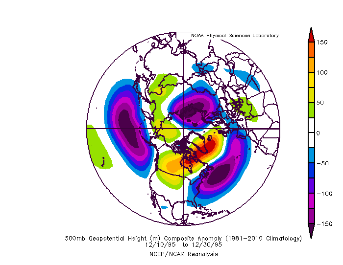
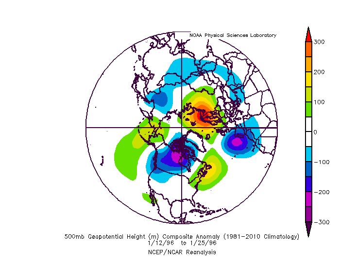
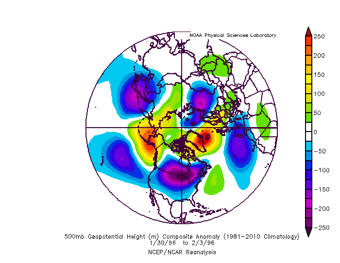
Well 1995/6 was the only example where we had a blockbuster winter on the whole...because it was the only nina where we had persistent blocking all winter long. So you have to judge things in proportion...if we only get a 10 day blocking period you can't expect to get 50" in that 10 day period. But if you get 10" of snow during that 10 day period...that was a productive period. But if you end up with only that 10" all winter the winter as a whole seems bad, but that blocking period wasn't the reason. The problem in a nina is we tend to do REALLY bad without blocking. So the whole rest of winter is often a barren wasteland outside those blocking episodes. Especially in a moderate or stronger nina. We can sometimes get lucky with some smaller snows in a weaker nina without blocking. So with that out of the way...limiting this to more recent 1980 onward ninas for Baltimore...and looking at periods of prolonged blocking...we had some very transient blocks that lead to an isolated minor event over the years...but lets look at just longer periods of blocking during moderate or stronger ninas. Links to the H5 January 1985 there was a major blocking period in January that lead to 2 snowfalls 2.5" and 3.7". This one you could argue underproduced...it was a pretty darn good looking pattern that only produced 2 storms and pretty minor. But it wasn't totally wasted it did snow twice during the 4 weeks of major blocking. But this was probably the biggest underproducing blocking period of the list I looked at. It was brutally cold at times though. https://imgur.com/Mwy5pwN the blocking broke down in February and a more typical nina pattern took over and that was winter over. March 99 really produced with several snow events in our area over a 2 week period. https://imgur.com/GVgexww We wasted most of the rest of that winter with a +NAO January 2000: this was probably the biggest over performer. We only had about a 10 day favorable blocking pattern that whole winter and we hit big time with 3 snowfall events across the area and 1 HECS. https://imgur.com/OexbcZJ December/January 2010-11: This one underperformed. A lot of bad luck. Somehow missed a miller a that took a weird curve and had a messy phase that screwed us over. We did get 2 snowfalls in January out of it, one advisory and one warning level event. So it wasn't a totally wasted period but we did miss out on the one HECS level event during this period...hit on that and it goes from slightly disappointing to epic. Oh well. Also...we tend to waste NAO blocking in December more then any other month...if you get blocking you would rather it later then earlier in winter. https://imgur.com/N8eM9FS Some notable weaker nina blocking periods that produced recently February 2006: lead to that one big storm...the pac ridge was REALLY flexing though and limited our ability to get anything more out of that period. March 2018: shame that block didn't come a month earlier but we did get one minor and one significant snowfall out of it even in March. The problem in those years wasn't that it didnt snow when there was blocking...it was mostly that it didnt snow much at all the rest of the winter when there wasn't blocking. As for 1996...There were 2 periods of extreme blocking that set off what happened. The first was early in the winter. It was actually fading by the time we got the HECS in January but the pattern was set in motion. We got several minor snows in December during the height of the block. This in Dec set everything in motion. But the second half of January the blocking faded and this was the only period where a typical nina pattern took hold and lead to our torch/melt/flood period. Then the blocking reloaded in late January/February and set off the second half of winter. That blocking would reload several times the rest of winter into April. If we were to get a repeat of that level of blocking that repeated multiple times all winter like 1996 we would likely end up with a very good winter again, nina or not. Not saying we necessarily do as well as 1996..there might have been some luck in there too...but we would snow quite a bit given the number of chances we would get with that kind of blocking all winter long (with the exception of 2 weeks in January).
-
We had a period of NAO blocking in 2013. Didn’t do is much good. Also a pretty good period in 2016 but it was cancelled in the means by extreme +NAO periods. Also March 2018. Blocking has been rare lately yes. But there are enough examples not to automatically assume its solar. I’m not saying it’s not. Just that we can’t say for sure.
-
MJO plots are all over the place because there are multiple waves sending conflicting signals...but it seems day 10-16 the wave out near the dateline becomes more prominent on the GEFS. That would be helpful tropical forcing for a change. The mean plot shows phase 6 because a wave back near the MC and the one near the dateline are battling each other in the means. But if the forcing near the dateline is dominant that may explain the change to a more favorable look. Or it's just a coincidence.
-
None of the models when on an island without any other support is a good bet, especially not at that range. There is a lot of moving parts in this pattern. We will see how it shakes out.
-
I wouldn't automatically attribute anything to just one factor without a lot more research and data. It could be the solar minimum. Or maybe its something else and its just a coincidence. Or maybe the solar minimum is just a part of the equation and there are other factors contributing also. There are way too many variables to just pin it on one thing. If it was that easy forecasting wouldn't be so difficult.
-
If you get just enough blocking it sets off a chain reaction that reconfigured a Nina look into a workable one. What I found was we actually do ok in a Nina if we have a cooperative AO/NAO. Problem is that’s not all that common. Nina tropical forcing tends to favor a +NAM state more often then not. But in cases where we do get help up top it can snow in a Nina.


