

Powerball
-
Posts
14,471 -
Joined
-
Last visited
Content Type
Profiles
Blogs
Forums
American Weather
Media Demo
Store
Gallery
Everything posted by Powerball
-
Chicago hitting 100*F this year was definitely not on my bingo card. What a Summer!
-

2023 Short/Medium Range Severe Weather Discussion
Powerball replied to Chicago Storm's topic in Lakes/Ohio Valley
Southern MI nto NE Ohio has been upgraded to an Enhanced Risk by the SPC. -
2023 Short/Medium Range Severe Weather Discussion
Powerball replied to Chicago Storm's topic in Lakes/Ohio Valley
Looking at the SPC mesoanalysis, the combined moisture/instability levels are close to unprecedented for the Detroit area (and it's only 7am). -
2023 Short/Medium Range Severe Weather Discussion
Powerball replied to Chicago Storm's topic in Lakes/Ohio Valley
Around 1000 strikes per minute now. -
Over 700 strikes/minute with those storms...
-
Gulf temps solidly in the upper 80s will also do that, even with drier than normal soils.
-
2023 Short/Medium Range Severe Weather Discussion
Powerball replied to Chicago Storm's topic in Lakes/Ohio Valley
Flood Advisory National Weather Service Detroit/Pontiac MI Issued by National Weather Service Grand Rapids MI 1233 PM EDT Wed Aug 23 2023 MIC099-125-163-232230- /O.NEW.KDTX.FA.Y.0018.230823T1633Z-230823T2230Z/ /00000.N.ER.000000T0000Z.000000T0000Z.000000T0000Z.OO/ Macomb MI-Oakland MI-Wayne MI- 1233 PM EDT Wed Aug 23 2023 ...FLOOD ADVISORY IN EFFECT UNTIL 630 PM EDT THIS EVENING... * WHAT...Flooding caused by excessive rainfall is expected. * WHERE...A portion of southeast Michigan, including the following counties, Macomb, Oakland and Wayne. * WHEN...Until 630 PM EDT. * ADDITIONAL DETAILS... - At 1233 PM EDT, Doppler radar indicated heavy rain due to thunderstorms. Minor flooding is ongoing or expected to begin shortly in the advisory area. - Some locations that will experience flooding include... Warren, Troy, Southfield, St. Clair Shores, Mount Clemens, New Baltimore, Grosse Pointe, Sterling Heights, Royal Oak, Birmingham, Clinton, Macomb Township, Detroit Zoo, Rochester Hills, Roseville, Eastpointe, Madison Heights, Oak Park, Hamtramck and Ferndale. - http://www.weather.gov/safety/flood PRECAUTIONARY/PREPAREDNESS ACTIONS... Turn around, don`t drown when encountering flooded roads. Most flood deaths occur in vehicles. && LAT...LON 4245 8319 4259 8326 4274 8280 4273 8276 4273 8274 4272 8273 4271 8273 4263 8276 4263 8277 4262 8277 4254 8281 4254 8282 4252 8284 4248 8284 4239 8288 4234 8296 4234 8297 $$ -
2023 Short/Medium Range Severe Weather Discussion
Powerball replied to Chicago Storm's topic in Lakes/Ohio Valley
While nothing severe, lightning tracker and radar does indicate this been a pretty stormy morning / early afternoon for parts of the city proper and the NE suburbs. Selfridge has apparently picked up over 1.5" of rain. -
Texas/Oklahoma 2023 Obs and Discussion
Powerball replied to Ed, snow and hurricane fan's topic in Central/Western States
At this point, for statistical posterity, hoping the OP GFS pulls a coup. Will need 100s at least through and including Monday to: 1. Crack the top 5 list for most 100*F+ days in a year. 2. Crack the top 10 list for most 100*F+ days in a month. -
Texas/Oklahoma 2023 Obs and Discussion
Powerball replied to Ed, snow and hurricane fan's topic in Central/Western States
Pouring salt on the wound, it seems both Conroe's airport and Hooks both made it to 100*F. -
Texas/Oklahoma 2023 Obs and Discussion
Powerball replied to Ed, snow and hurricane fan's topic in Central/Western States
Seems both San Antonio and Houston officially broke their 100*F streak today. Austin eeked out an intra-hour 100*F before getting an outer band of t'storms from Harold. -
I'm sure he'd find something to complain about.
-
Texas/Oklahoma 2023 Obs and Discussion
Powerball replied to Ed, snow and hurricane fan's topic in Central/Western States
-
Texas/Oklahoma 2023 Obs and Discussion
Powerball replied to Ed, snow and hurricane fan's topic in Central/Western States
-
Texas/Oklahoma 2023 Obs and Discussion
Powerball replied to Ed, snow and hurricane fan's topic in Central/Western States
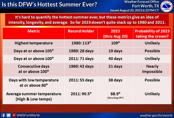
I'm surprised DFW's records for 100*F+ days are notably higher than San Antonio's, even with a much larger UHI and being 3x as large... -
Texas/Oklahoma 2023 Obs and Discussion
Powerball replied to Ed, snow and hurricane fan's topic in Central/Western States
https://sanantonioreport.org/san-antonio-weather-heat-record-summer-2023/ -
Texas/Oklahoma 2023 Obs and Discussion
Powerball replied to Ed, snow and hurricane fan's topic in Central/Western States
-
Texas/Oklahoma 2023 Obs and Discussion
Powerball replied to Ed, snow and hurricane fan's topic in Central/Western States
-
Texas/Oklahoma 2023 Obs and Discussion
Powerball replied to Ed, snow and hurricane fan's topic in Central/Western States
For the 3rd time this seaaon, DFW achieved a high of 109*F today. -
Texas/Oklahoma 2023 Obs and Discussion
Powerball replied to Ed, snow and hurricane fan's topic in Central/Western States
As of 2pm, today's record high of 107*F at DFW (previously set in 2011) has been broken (currently 108*F). -
Texas/Oklahoma 2023 Obs and Discussion
Powerball replied to Ed, snow and hurricane fan's topic in Central/Western States
-
Texas/Oklahoma 2023 Obs and Discussion
Powerball replied to Ed, snow and hurricane fan's topic in Central/Western States
It's already 102*F at DFW as of 11am... -
Texas/Oklahoma 2023 Obs and Discussion
Powerball replied to Ed, snow and hurricane fan's topic in Central/Western States
Update: The high was actually 108*F, breaking the previous record. -
Texas/Oklahoma 2023 Obs and Discussion
Powerball replied to Ed, snow and hurricane fan's topic in Central/Western States
DFW tied the record high of 107*F today (previously set in 2011), and also set another record maximum low of 85*F (previously 82*F set in 2006). -
We finally got some of that down here for the first time this season yesterday. Made for a nice sunrise and sunset with thick haze.

