

Powerball
-
Posts
14,471 -
Joined
-
Last visited
Content Type
Profiles
Blogs
Forums
American Weather
Media Demo
Store
Gallery
Everything posted by Powerball
-

Texas/Oklahoma 2023 Obs and Discussion
Powerball replied to Ed, snow and hurricane fan's topic in Central/Western States
And another DFW record. We're now on day 5... -
Texas/Oklahoma 2023 Obs and Discussion
Powerball replied to Ed, snow and hurricane fan's topic in Central/Western States
For context, there were 47 days in 2022... -
Texas/Oklahoma 2023 Obs and Discussion
Powerball replied to Ed, snow and hurricane fan's topic in Central/Western States
Unless something wild happens this evening (I.E. rogue pop-up t'storm at/near the airport), yet another record maximum low was set today at DFW of 86*F (previous record was also 85*F in 2011). In fact, that ties for the all-time record (also most recently set in 2022). -
Texas/Oklahoma 2023 Obs and Discussion
Powerball replied to Ed, snow and hurricane fan's topic in Central/Western States
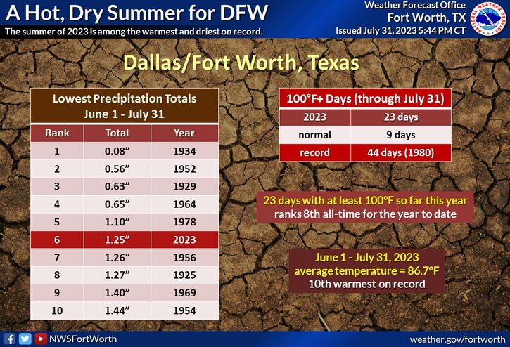
It seems the latest ensemble runs are even backing off on that. And Larry Cosgrove is thinking little overall change in the pattern until after Labor Day. To-date, this Summer is the 7th hottest on record for DFW, and we're quickly catching up to the records set in the Big 4 (1980, 2011, 1998 and 2022). Back in May, had you told me we would have a backloaded torch of a Summer this year with the persistent blocking and strengthening El Nino, I would have laughed. Yet, here we are... -
Texas/Oklahoma 2023 Obs and Discussion
Powerball replied to Ed, snow and hurricane fan's topic in Central/Western States
Poor thing... -
Texas/Oklahoma 2023 Obs and Discussion
Powerball replied to Ed, snow and hurricane fan's topic in Central/Western States
Another record maximum low of 85°F was set this morning at DFW (previous record of 84°F was again in 2011). -
Texas/Oklahoma 2023 Obs and Discussion
Powerball replied to Ed, snow and hurricane fan's topic in Central/Western States
DFW tied the record high of 107*F today, *AND* broke the record high minimum temp with a low of 85*F (previously 83*F). Both records were last set in 2011... -
Texas/Oklahoma 2023 Obs and Discussion
Powerball replied to Ed, snow and hurricane fan's topic in Central/Western States
-
I see a bunch of new names on the Outlooks issued today. I'm guessing these are new grad hires or interns...
-
Texas/Oklahoma 2023 Obs and Discussion
Powerball replied to Ed, snow and hurricane fan's topic in Central/Western States
We will be getting outflows in North Texas from the storms in OK (one's pushing through now), but it seems other than intermittent cloud cover and a wind shift, they may offer little relief from the heat. EDIT: Not so fast. There's storm initiation in Montague County right now. -
But for now, they're Bunting...
-
Texas/Oklahoma 2023 Obs and Discussion
Powerball replied to Ed, snow and hurricane fan's topic in Central/Western States
Treating Extreme Heat in Dallas as a ‘Moral Issue’ https://www.dmagazine.com/frontburner/2023/08/treating-extreme-heat-in-dallas-as-a-moral-issue/ -
2023 Short/Medium Range Severe Weather Discussion
Powerball replied to Chicago Storm's topic in Lakes/Ohio Valley
And in other news, water is wet... -
Texas/Oklahoma 2023 Obs and Discussion
Powerball replied to Ed, snow and hurricane fan's topic in Central/Western States
Models are still struggling with how to handle the overall pattern beyond Sunday, it seems in part because of the MJO. If the MJO remains in the COD (possible), it may supersede effects from the developing +PNA / -NAO / -AO which should allow for the hot & dry pattern to continue uninterrupted across much of the Southern Plains. But if the MJO sneaks into Phase 8 / Phase 1, that may translate to deeper and longer duration troughing, at least for the early part of next week. And of course regardless of the outcome with the upper level pattern, for North Texas there's still some question on a mesoscale level about the influence any outflow boundaries from nearby thunderstorms complexes in OK / AR will have. -
Texas/Oklahoma 2023 Obs and Discussion
Powerball replied to Ed, snow and hurricane fan's topic in Central/Western States
It's so hot that FWD can't even think straight... -
Texas/Oklahoma 2023 Obs and Discussion
Powerball replied to Ed, snow and hurricane fan's topic in Central/Western States
Welp, I spoke it into existence. As of 4pm, today's record high of 107*F has been tied at DFW... -
Texas/Oklahoma 2023 Obs and Discussion
Powerball replied to Ed, snow and hurricane fan's topic in Central/Western States
What's crazier to me is that all but one of the top 10 coldest Summers on record are from 30+ years ago (and most of them are from 50-100+ years ago). On top of that, DFW may just see back-to back top 10 hottest Summers on record if the current pattern continues through August (still skeptical). And that will mean 5 of the top 10 years for the hottest Summers would have been in the past 15 years. EDIT: And lastly, it would also be impressive for 2023 to achieve top 10 hottest Summer status without a single record high being tied/broken (still has yet to happen). EDIT 2: Disregard the 1st edit, lol... -
To start the month, the smoke is back in full force!
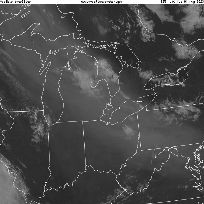
-
Texas/Oklahoma 2023 Obs and Discussion
Powerball replied to Ed, snow and hurricane fan's topic in Central/Western States
-
Texas/Oklahoma 2023 Obs and Discussion
Powerball replied to Ed, snow and hurricane fan's topic in Central/Western States
The record highs for DFW today and tomorrow are 106*F and 107*F respectfully. While low-hanging fruit compared to the records in 2011, 2022 and 1980, we have a decent shot at breaking or tying both of them. -
Texas/Oklahoma 2023 Obs and Discussion
Powerball replied to Ed, snow and hurricane fan's topic in Central/Western States
Precipitation is going to be a bit more tricky to predict beyond next week, especially for us in North Texas as it will be dependent on both the timing/strength/track of subtle shortwaves riding the edge of the flattening ridge and the influence of outflow boundaries from MCS in OK. We saw a similar pattern back in early/mid-June. I wouldn't expect the ensembles or weeklies to pick up on this either. -
62 MPH wind gust reported at KSTL. EDIT: It was actually a 79 MPH wind gust.
-
Pretty decent MCS pushing towards St. Louis. Shear's lacking, but it's tied to a MCV / cold pool and it has that "long-lived" look to it as well. Still appears to be somewhat elevated now, but per the SPC mesoanalysis page for 0-3km CAPE, the stable layer has almost eroded with clear skies ahead of it and convective temps being reached.
-
Texas/Oklahoma 2023 Obs and Discussion
Powerball replied to Ed, snow and hurricane fan's topic in Central/Western States
There are early indications that the ridge will finally break down by next weekend, and shift back westward over Phoenix, as blocking over Greenland intensifies. Probably not an earth shattering change though, just a return to seasonal temps. -
2023 Short/Medium Range Severe Weather Discussion
Powerball replied to Chicago Storm's topic in Lakes/Ohio Valley
I'll take the bait... I'm not laughing at your health problems (and I certainly wish you get the help you deserve). I'm laughing at 2 things: 1. Your clapbacks at Stebo, because I just plain don't like him (the reason why has nothing to do with you). 2. The fact that your extremely unrealistic expectations for weather in Grand Rapids in spite of its climo, which has been explained to you ad-nauseam, has you becoming so unhinged that you're devolving into nonsensical diatribes over it with strangers on an internet forum. And I already suspected you have health problems, FYI. Just not the physical kind with the way you've been carrying on. I actually think it's sad (not funny), which is why I've been giving you Weenie reactions. I hope this helps and please be blessed!


