

Powerball
-
Posts
14,471 -
Joined
-
Last visited
Content Type
Profiles
Blogs
Forums
American Weather
Media Demo
Store
Gallery
Everything posted by Powerball
-

Texas/Oklahoma 2023 Obs and Discussion
Powerball replied to Ed, snow and hurricane fan's topic in Central/Western States
I just can't understand for the life of me why FWD is being pedantic about an Excessive Heat Warning, especially given HOU has issued one despite relatively less oppressive ambient temps and heat indices. -
Texas/Oklahoma 2023 Obs and Discussion
Powerball replied to Ed, snow and hurricane fan's topic in Central/Western States
Jacuzzi...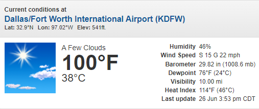
-
Texas/Oklahoma 2023 Obs and Discussion
Powerball replied to Ed, snow and hurricane fan's topic in Central/Western States
Perhaps the most impressive part about this heat wave is that were getting temps 100*F or greater while dewpoints hold in the low/mid 70s through peak heating. It's not often that happens, especially this far NW from the Gulf / swamp land (though maybe in Houston / Louisiana / Arkansas / Mississipi)... -
Texas/Oklahoma 2023 Obs and Discussion
Powerball replied to Ed, snow and hurricane fan's topic in Central/Western States
Official high yesterday at DFW was an intra-hour 101*F, warmest of the year so far.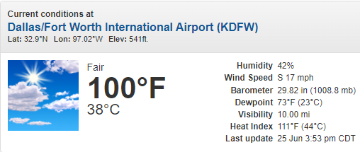
-
-
Yeah, definitely a solid event for that area (beggara can't be choosers).
-
FWIW, the special 20z DTX sounding had an impressive Inverted-V look.
-
That's not a bad-looking (as in it's ok) shelf cloud at all...
-
Nasty-looking bow echo. Will track right through the city if it holds...
-
Texas/Oklahoma 2023 Obs and Discussion
Powerball replied to Ed, snow and hurricane fan's topic in Central/Western States
At last...
-
Texas/Oklahoma 2023 Obs and Discussion
Powerball replied to Ed, snow and hurricane fan's topic in Central/Western States
Another 99*F for the books at DFW today. The first 100*F day of the year should finally happen tomorrow. -
A similar thing happened to a NWS meteorologist in Indianapolis, simply because they translated warnings/advisories into Spanish. It's mental illness.
-
2023 Short/Medium Range Severe Weather Discussion
Powerball replied to Chicago Storm's topic in Lakes/Ohio Valley
Nice to see some of you finally get some severe action. -
Hi-Res models did loosely hint at the possibility, but they were struggling with gauging the strength of the cap. That said, the cold pool / outflow boundary from the MCS across KS / OK Wednesday morning was just enough of a trigger to weaken it. Had there been a bit stronger forcing / shear, it might have been a repeat of 6/9/19.
-
Per SPC, there were two reports of a 97 MPH wind and a 82 MPH wind gust reported in Harris County.
-
Texas/Oklahoma 2023 Obs and Discussion
Powerball replied to Ed, snow and hurricane fan's topic in Central/Western States
DFW only topped off at 92*F today due to more cloud covers and now the unexpected cap busters. Any shot at the first 100*F high is now off the table until Saturday at the earliest. -
Some nice unexpected cap busters across DFW right now. Mostly sub-severe, but very intense lightning (ton of CTG strikes).
-
Texas/Oklahoma 2023 Obs and Discussion
Powerball replied to Ed, snow and hurricane fan's topic in Central/Western States
-
Texas/Oklahoma 2023 Obs and Discussion
Powerball replied to Ed, snow and hurricane fan's topic in Central/Western States
DFW did have several hours with a 79*F dewpoint and heat indices exceeding 110*F (topping out at 115*F). -
Texas/Oklahoma 2023 Obs and Discussion
Powerball replied to Ed, snow and hurricane fan's topic in Central/Western States
Another 99*F for the books at DFW, unless a sneaky spike to 100*F happens within the next hour. -
Texas/Oklahoma 2023 Obs and Discussion
Powerball replied to Ed, snow and hurricane fan's topic in Central/Western States
It's kind of funny, really. Last week, it was looking like DFW would be seeing days upon days of 100*F+ weather and sunny/dry conditions with no end in sight. There was so much hype about record-breaking oppressive heat. Fast forward to today and not only has DFW yet to hit 100*F+, but it's only been "seasonably warm" and there's a good chance the first 100*F+ day may not even happen at all with this "heat wave" before it ends on Wednesday. Plus, much of the period has been pretty cloudy due to persistent convective debris and/or post-outflow stratus clouds. EDIT: The long-advertised heat wave did verify for San Antonio, Austin and (to a lesser extent) Houston though. And granted, the humidity was certainly imrpessive althugh actual temps fell well short of expectations. -
-
-
-
Between increased cloud cover, a weaker shortwave, somewhat weaker low level flow and somewhat drier air, today's setup looks a bit more messy than Thursday's. That's not saying much though, because the parameters are still impressive when you disregard Thursday's extremely high ceiling. It's looking more like a damaging straight-line wind threat today than anything. And it seems there will potentially be 2 separate areas of organized activity to watch later this afternoon / tonight. 1. I-20/I-30 corridors in Texas from Abilene to Texarkana (including DFW) 2. North/Central OK, including OKC and Tulsa. Many of the areas that got hit hardest on Thursday in Southern OK and parts of North Texas may very well be spared today.

