Powerball
-
Posts
14,471 -
Joined
-
Last visited
Content Type
Profiles
Blogs
Forums
American Weather
Media Demo
Store
Gallery
Everything posted by Powerball
-
It can definitely be explained by corn evapotranspiration in part, in addition to the cooler lake waters acting acting as buffers. As far as Corn, the coverage is fairly miniscule in Michigan compared to IA/IL/IN/MN. It should also be noted, the climatological peak for severe weather in that part of the country (despite what seems to be the common misconception) is late June / early July. April and May aren't all that favorable for severe weather outside of the Central/Southern Plains. And yes, Chinook Winds are a thing in the Western Plains (The Dakotas, Nebraska, KS, OK and TX). But not so much in IA/MN/WI/IL/IN/MO which all see a significantly greater frequency of severe weather than Michigan.
-
Maybe you misunderstood what I said, because that was my point exactly. The fact that most "Training Storms" are not rooted at the surface is why they have an easier time surviving trips across the lake, versus surface-based storms which are more likely to produce severe weather. There have been plenty of setups where Michigan got a good feed of moisture from the gulf while other areas did not. It's all dependent on jet dynamics and the orientation of the trough. Now of course, that moisture advecting northward into Michigan from the Gulf of Mexico is traveling hundreds of miles over relatively barren land, so of course it's going to be modified & shallow by the time it reaches your latitude. This is unlike in the Plains where it's a lot harder for gulf moisture to mix out because of the added evapotranspiration from the corn fields. Synoptically-speaking, there's nothing special about Michigan and its location that explains the lower frequency of severe weather. It has everything to do with features such as the cool lake waters and the relative lack of crop/vegetation that holds extra moisture. That's not true. https://www.washingtonpost.com/climate-environment/2022/08/02/corn-sweat-midwest-plains-heatwave/ The ideal setup for training storms is the same everywhere, and it's not specific to Michigan. The truth is though, training events are pretty unusual in their own right everywhere (due to the nature of how convection works). Most locations don't experience them often.
-
Today will be more of a wet microburst setup. Shear and forcing both look pretty mediocre, but the atmosphere seems primed for precip loading with the temperature spread expected at the surface.
-
Will be interesting to watch convective trends for DFW the next few hours. The cap has completely eroded and pretty aggressive moisture advection is underway, but the better forcing is well to the NW. That said, some fairly modest convergence exists along the dry line and it's beginning to trigger some convection right now around Stephenville (not projected by the CAMS). Will also have to see what happens with the outflow boundaries from convection upstram across Southern OK, which could also act as triggers. I did notice the marginal risk area was expanded pretty far SE in the last update.
-
That's because storms tend to be rooted higher up in the atmosphere at night (and also feed off instability rooted higher up in the atmosphere), so the surface marine layer has much less of an impact on their intensity. As far as moisture, yes, all the corn fields in IA/IL do help to give areas west of the lakes an extra boost (evapotranspiration). That doesn't have much to do with how moisture advects northward from the gulf though.
-
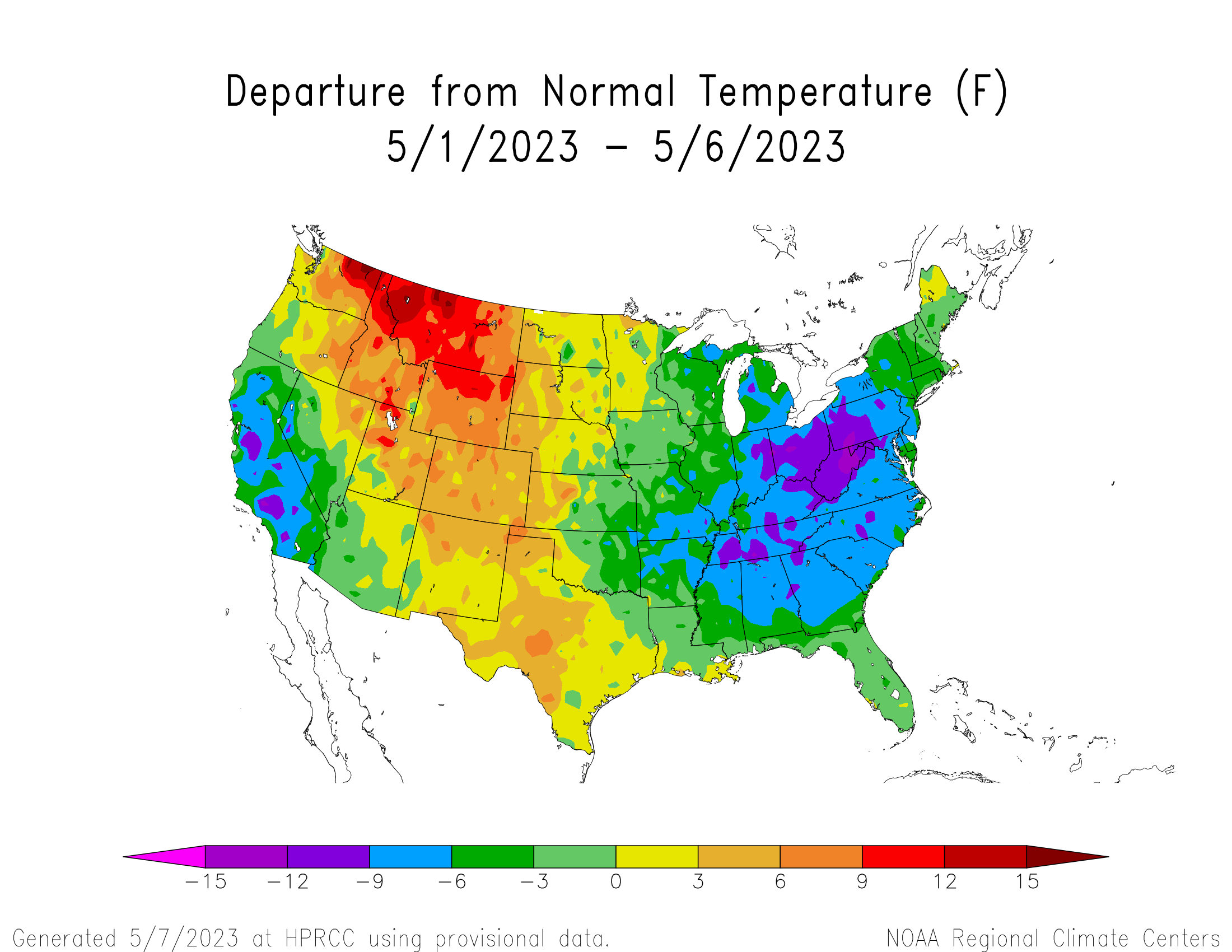
A +1.6*F departure where in the first week of May?
-
As already mentioned, no one said the first half of May would be cold. Larry Cosgrove was the closest, and even he predicted that the pattern would break by 5/9. That said, the first week of May has certainly been cold relative to average, which was expected by most.
-
-
FWD did add heavy rain wording to the grids. Damaging straight lines winds could be a greater threat today versus the past 2 days with much more precip loading and what looks to be a weak shortwave moving through (cold pool potential). Hi-Res models do look more bullish for the Metroplex than they did Thursday and Friday.
-
After full morning sunshine, what's left of the low cloud field from the Hill Country has moved into DFW and slowed down the rise in temps. We'll see how quickly it mixes out entirely and what impacts that has on destabilization, unlike yesterday where there was virtually no cloud obstruction
-
3rd time's the charm, right?
-
-

Texas/Oklahoma Discussion & Obs Thread 2022
Powerball replied to It's Always Sunny's topic in Central/Western States
Stephenville also hit 100*F. -
Texas/Oklahoma Discussion & Obs Thread 2022
Powerball replied to It's Always Sunny's topic in Central/Western States
Oh, I failed to mention, 95*F was the previous record high for today (set in 1984). It has been broken with an official high of 96*F at DFW -
-
Severe Thunderstorm Watch has been issued until 10pm. It includes all of DFW and the I-35 corridor from the OK border to Austin.
-
Texas/Oklahoma Discussion & Obs Thread 2022
Powerball replied to It's Always Sunny's topic in Central/Western States
It's currently 100*F in Mineral Wells. -
-
I love it that most of us are finally getting satisfactory weather.
-
Word on the street is the HRRR doesn't look too shabby either.
-
Also, IMO, the date on this thread should be extended through 5/8 (at least).
-
I haven't really invested much time/energy into this marginal setup, but seeing that sounding and what you say about the 3km NAM's depiction...

-
Texas/Oklahoma Discussion & Obs Thread 2022
Powerball replied to It's Always Sunny's topic in Central/Western States
Thr forecast high today has been bumped to 96*F. -
Texas/Oklahoma Discussion & Obs Thread 2022
Powerball replied to It's Always Sunny's topic in Central/Western States
90s are now in the forecast for DFW through at least Tuesday. -
Can't help but chuckle at the SPC They've been bouncing Dallas in and out of the Slight Risk area with every new outlook. Can't make up their minds, lol...