Powerball
-
Posts
14,471 -
Joined
-
Last visited
Content Type
Profiles
Blogs
Forums
American Weather
Media Demo
Store
Gallery
Everything posted by Powerball
-
So in effect, the NWS is just simplifying the criteria for WSW. As an example, going forward, a 7" snowfall would meet the critetia for a Winter Storm whether it falls in 12 hours or 24 hours.
-

Texas/Oklahoma 2023 Obs and Discussion
Powerball replied to Ed, snow and hurricane fan's topic in Central/Western States
Welp, might have spoke too soon about those 90s, lol... -
I'll take 55 days of 100*F+ weather over that crap any time. Don't miss that *AT* *ALL* Meanwhile, it's been sunshine and blue skies as far as the eye can see here. #GodBlessTheSunbelt
-
How lovely...
-
You can also the Visible Satellite go dim as well... https://www.aviationweather.gov/satellite/plot?region=us&type=vis&date=
-
Currently at a mall parking garage to watch the Annular Solar Eclipse, as an appetizer for the real fun 6 months from now. Hopefully, you guys have much better luck weather-wise by then...
-
I have no dog in the fight either way, since I already live in a region where warm/snowless winters are all but guaranteed. I'm mostly here for the lulz. Still, was just making an observation as a bystander who means no harm...
-
Spamming the board with images of the shitty CFS model isn't very scientific of a forecast method. Just saying...
-
If you listened to WWJ (950 AM) during the afternoon rush in the 2000s, Sonny Eliot was the regular on-air metereologist. This was long after he had retired from TV (he was the Chief Meteorologist at WDIV until the late 70s). While he was a fine weatherman, he wasn't nearly as revered as Tom Skilling has been for his technical expertise. It was more so his personality and eccentric way of delivering forecasts that won him favor with his audience. What was unique about him was that he was always perky on-camera (although I heard he was kind of difficult to work with behind the scenes), cracking jokes and speaking in riddles. https://youtu.be/0WyBMhnmGb8?si=Mz1fmA1iaEGLbCmm
-
I was going to ask you aboutt that and I'm glad you addressed it, because I figured (and I recall you saying in the past) there wasn't the greatest correlation historically between November weather and how winters end up. Definitely gotta be careful with putting too much weight on any recent trends.
-
IYKYK...
-
-
Bless his heart...
-
Texas/Oklahoma 2023 Obs and Discussion
Powerball replied to Ed, snow and hurricane fan's topic in Central/Western States
Now that the 90s & 100s seem to be mostly gone for good (for sure after this Thursday)... Revisiting this post, it's crazy how many records we set or tied this Summer, for it being mostly backloaded. 1980 and 2011 both still reign as kings, but this year was definitely a solid runner up behind the 2 by most measures. And that doesn't even speak to September. I suspect JAS period was also amongst the warmest on record for DFW, similar to how MJJ was in 2022. -
Texas/Oklahoma 2023 Obs and Discussion
Powerball replied to Ed, snow and hurricane fan's topic in Central/Western States
There wasn't much thunder here either. I heard maybe one good crack. -
Texas/Oklahoma 2023 Obs and Discussion
Powerball replied to Ed, snow and hurricane fan's topic in Central/Western States
On another note, DFW overachieved temp-wise yesterday as it tied the record high of 96*F from 1898. This was with quite a bit of cloud cover too. -
It's going to be entertaining lurking and watching @hardypalmguy troll @michsnowfreak the next 6 months. He's being a good sport about it though.
-
Texas/Oklahoma 2023 Obs and Discussion
Powerball replied to Ed, snow and hurricane fan's topic in Central/Western States
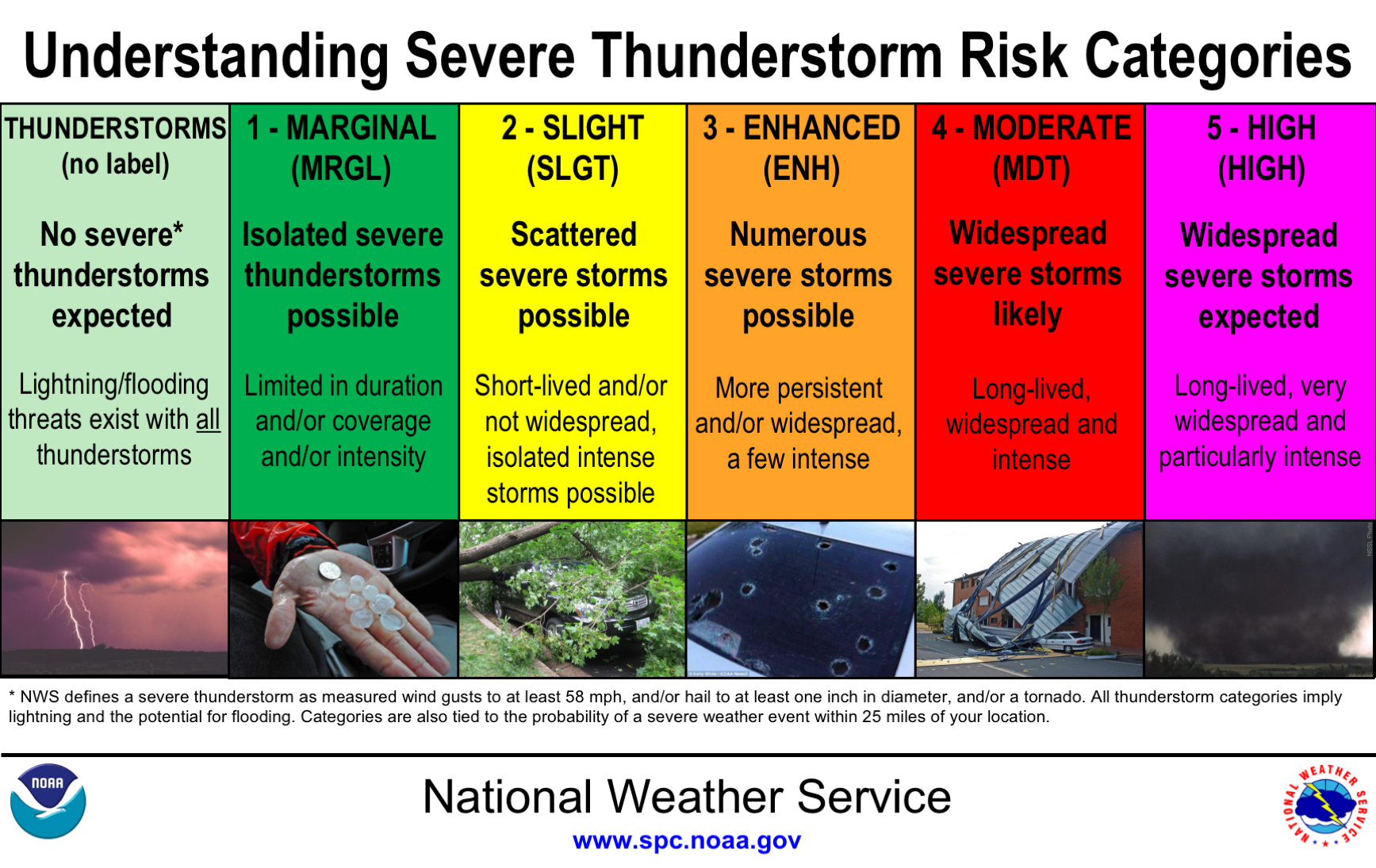
Respectfully, you can keep your snark to yourself. So an isolated part of the Metroplex saw 70+ MPH winds. Most areas did not. An isolated high-end report did not make enough justification for an enhanced risk outlook IMO. In fact, my take aligns exactly with the official SPC definitions: I stand by what I said and you're free to feel whatever type of way about it.
-
Texas/Oklahoma 2023 Obs and Discussion
Powerball replied to Ed, snow and hurricane fan's topic in Central/Western States
Also, I will say, I did see widespread observations of wind gusts in the 35-45 MPH range, which (although sub-severe) is something. And that was likely in part due to the somewhat lower than expected RH levels mentioned, as that helped to enhance the downdrafts a bit (though still not enough to overcome the cooling boundary layer). -
Texas/Oklahoma 2023 Obs and Discussion
Powerball replied to Ed, snow and hurricane fan's topic in Central/Western States
Only 3 confirmed reports so far in DFW. Granted, there may be more forthcoming, but in all likelihood still not enough to be enhanced risk worthy IMO. Aside from that overachieving mini-bow echo that moved into FW proper (and actually weakened shorty thereafter), it's been largely "more bark than bite" severe-wise, with impressive shear on paper that didn't translate into a more impressive event. And that's pretty typical for these nighttime events in the Fall, which is why I didn't really buy into the hype. That being said, it's certainly been a solid event rain-wise for the Metroplex and has been a prolific lightning producer. -
Texas/Oklahoma 2023 Obs and Discussion
Powerball replied to Ed, snow and hurricane fan's topic in Central/Western States
The severe threat is definitely there. I just disagree that it's great enough for an upgrade to an enhanced risk (as you seem to) for DFW. The better potential will be NW of here, where the activity will occur during or just after peak heating. -
Texas/Oklahoma 2023 Obs and Discussion
Powerball replied to Ed, snow and hurricane fan's topic in Central/Western States
To clarify, the reason I say somewhat marginal instability for severe weather is because much of that instability on the sounding you presented is elevated. Even the CAMs indicate a stable layer forming near the surface by the time the storms arrive into DFW (temps only in the low 80s and dewpoints in the low/mid 70s), which will significantly temper downburst potential. Instability and moisture levels are definitely good enough for prolific rain producers and frequent lightning though, which is already pretty well covered in the current outlooks/forecasts. -
Texas/Oklahoma 2023 Obs and Discussion
Powerball replied to Ed, snow and hurricane fan's topic in Central/Western States
Not going to happen due to less than ideal timing (late evening hours) and already somewhat marginal instability with an unimpressive dewpoint/temp spread, likely preventing much of that shear from mixing down to the surface. The enhanced risk is mainly for very large hail (2-3"+) with the initial activity. -
Texas/Oklahoma 2023 Obs and Discussion
Powerball replied to Ed, snow and hurricane fan's topic in Central/Western States
In all likelihood, this September will end up being the 2nd warmest on record for DFW. Only September 2019 was warmer. -
I'm good, as the trade off will be not having to deal with never-ending freezing temps a couple months from now.