

Powerball
-
Posts
14,471 -
Joined
-
Last visited
Content Type
Profiles
Blogs
Forums
American Weather
Media Demo
Store
Gallery
Everything posted by Powerball
-
On a related note...
-

Winter 2023/24 Medium/Long Range Discussion
Powerball replied to Chicago Storm's topic in Lakes/Ohio Valley
Winter hasn't even started yet, though... -
Thats like saying it's a dry heat...
-
Winter 2023/24 Medium/Long Range Discussion
Powerball replied to Chicago Storm's topic in Lakes/Ohio Valley
Aqua Teen Hunger Force. EDIT: I take fault for that. I accidentally typed "in" instead of "on." -
Yes. https://www.scientificamerican.com/article/watch-out-tornado-alley-is-migrating-eastward/ https://www.nature.com/articles/s41612-018-0048-2
-
Winter 2023/24 Medium/Long Range Discussion
Powerball replied to Chicago Storm's topic in Lakes/Ohio Valley
It's great that ATHF is back on the air. -
Right. Will have to wait until after New Years in order for the days in totality to get longer.
-
Spoke too soon, buddy...

-
December 2021 was definitely unprecedented severe weather wise. Had 2 of the worst outbreaks in history, let alone in December or in the winter time. DFW also shattered its record warmest December on record by a whopping 7.3 degrees, warm enough that it even surpassed all but 10 of the warmest Novembers on record.
-
Saw this on Reddit, taken in Goodlettsville (northern suburb of Nashville).
-
Winter 2023/24 Medium/Long Range Discussion
Powerball replied to Chicago Storm's topic in Lakes/Ohio Valley
Would be lovely. -
You have a point, but you're taking the banter too seriously. People are just frustrated about the general pattern, and the evolution of the storm that thread was created for only added to the frustration. People tend ot become irrationally flippant when they're frustrated.
-
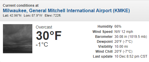
Texas/Oklahoma 2023 Obs and Discussion
Powerball replied to Ed, snow and hurricane fan's topic in Central/Western States
DFW tied the record high of 80*F today, last set in 1977. -
Isn't that par for the course for your neck of the woods in a normal winter though?
-
So in other words, the same as every winter...
-
2nd biggest snowstom for Detroit (~19") .. Biggest was back in the 1880s (in April at that) with ~23" ~2 feet
-
lol.
-
I wouldn't necessarily say Internet forums are declining. I'd say it's a combination of: *Millennials getting older, busy with their careers and have settled down with kids/partners. Even during the hey dey, the weather boards were mostly a teen and early 20-something ordeal, a time when you have virtually no responsibilities, good health and are full of adrenaline. Gen Z and Alpha are also smaller in size than Millennials were (thus a smaller audience of young weather weenies as a whole). *Society has become a lot more, socially, politically and economically polarized since the 2000s and early 2010s. So much of the community is now bifurcated into our own little echo chambers.
-
It's been a while since I've seen a severe weather setup bust as bad as this one.

-
To each his/her own. The food itself is not fancy or gourmet, but it's about the entire experience. At In-N-Out, you always get excellent customer service, fresh food and the lines are fast. The prices are also relatively low. Culver's is good too, but a lot of its food (besides the Ice Cream) is frozen/prepackaged, service can be inconsistent and it's more expensive. But regardless, we're still a long ways off before In-N-Out's palm trees can survive a Great Lakes winter.
-
Some of us lucky few are blessed to live in a region with both.
-
Maybe then, y'all can experience the greatness that is In-N-Out...
-
With the unprecedented warmth of the waters down there, I'm actually a bit surprised it took until this late in the season for a Hurricane Otis. The US shoreline really dodged a bullet this season.
-
Texas/Oklahoma 2023 Obs and Discussion
Powerball replied to Ed, snow and hurricane fan's topic in Central/Western States
-
And the truth is, the criteria is somewhat arbitrary and will never be perfect. Just as before, the decision for headlines will ultimately boil down to forecaster judgement. I can also understand the west-wind LES belts in MI having a slughtly higher threshold of 8", as they see heavy snow events more frequently.


