

Powerball
-
Posts
14,471 -
Joined
-
Last visited
Content Type
Profiles
Blogs
Forums
American Weather
Media Demo
Store
Gallery
Everything posted by Powerball
-
Indeed.
-

Texas 2024 Discussion/Observations
Powerball replied to Stx_Thunder's topic in Central/Western States
Daytime temp at DFW never got above 16*F yesterday, which would have tied the record minimum high if not for the midnight high of 21*F Also, DFW has so far tied the record low of 11*F for today. -
Texas 2024 Discussion/Observations
Powerball replied to Stx_Thunder's topic in Central/Western States
This is the 2nd time in 4 winters living in DFW that Lake-Effect Snow has occurred (it also happened in December 2022). Crazy! -
I have to echo everyone's sentiment. Definitely a weird storm.
-
-
More lightning showing up on tracker now up around Port Huron.
-
Decent dry slotting is surging in. Best case scenario, the precipitation tapers to flurries/drizzle before the warm tongue completely takes over.
-
I'm disappointed in you Detroit area guys for burying the lead. East side of the city is getting slammed with TSSN (ton of lightning on tracker, and per my mom).
-
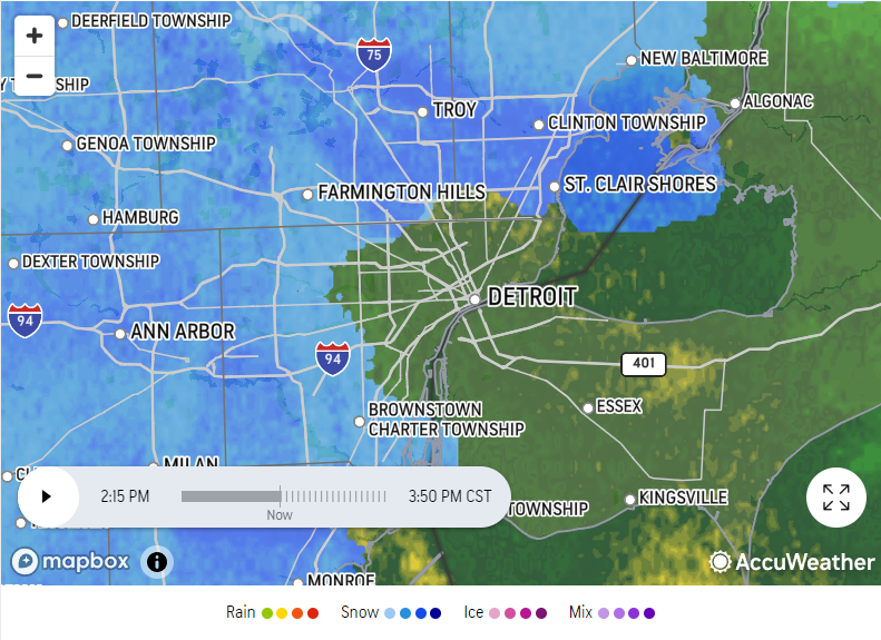
Accuweather's futurecast keeps the spotch over Detroit proper and the immediate suburbs as rain for a little while longer (another hour or so at least), with the transition line slowly enroaching from the North and South. We'll see if it's right or wrong.
-
It does align with the ASOS reports as of 2pm.
-
lol...
-
No clue how accurate it is, but DET is reporting straight rain, and MTC is reporting a rain/snow mix.
-
FWIW, 18z HRRR is finally colder for the Detroit area, showing predominately snow.
-
Most sites in NW Ohio look to be reporting moderate/heavy snow
-
There were multiple (so far unofficial) reports of sub-severe hail across Dallas and Collin Counties per Twitter.
-
Was Jim Cantore also live on scene?
-
If any CWA is in the toughest spot right now headline-wise, I'd definitely say it's DTX. Hypothetically, even if snowfall amounts for Metro Detroit were a more conservative 2-4" (instead of taking the current model output verbatim), snowfall rates could conceivably exceed 1" per hour and this would be happening right at rush hour with likely 20-30 MPH wind gusts.
-
Might have to watch that part of the line along I-20 / I-30 headed towards downtown. Looking pretty beefy on radar.
-
Seems Broyles might have gotten this one right. Pretty impressive MULIs (over -10) and Mid-Level Lapse Rates (over 8 C/KM) right now.
-
Got a line ripping right over the Metroplex. Not severe thus far, but frequent lightning and loud cracks of thunder.
-
Believe it or not, GHD #1. It was consistently the furthest NW / deepest / warmest the entire time and ended up being spot on.
-
Well, there was February 2010...
-
A part of me wants Detroit to see a winter of relative futility, just to see how @michsnowfreak would react. I know if all else fails, February seems to always come through to save the day. That said, January so far isn't looking as hot as the broader pattern originally suggested for snow prospects in/around the Motor City (it's looking cold but dry)...
-
Amen to that!
-
February 2-3, 2022 Winter Storm here in Dallas... BTW, if the former Lafayette, IN members (Hoosier & ChicagoWX) were still actively posting, they could also attest to experiencing pingers for roughly the same length of time during GHD 2011. All of their old posts about the event are still easily searchable. Point being, after experiencing such an event, I'm fairly numb to relatively intermittent pingers now. It can be so much worse.


