

Stormchaserchuck1
-
Posts
4,687 -
Joined
-
Last visited
Content Type
Profiles
Blogs
Forums
American Weather
Media Demo
Store
Gallery
Everything posted by Stormchaserchuck1
-

Jan 15-16 Storm Thread 3: Obs and Disco
Stormchaserchuck1 replied to stormtracker's topic in Mid Atlantic
21z RAP keeps the precip around tomorrow.. and goes 4-6" in northern MD -
Jan 15-16 Storm Thread 3: Obs and Disco
Stormchaserchuck1 replied to stormtracker's topic in Mid Atlantic
18z GFS is a good 3-4" here. -
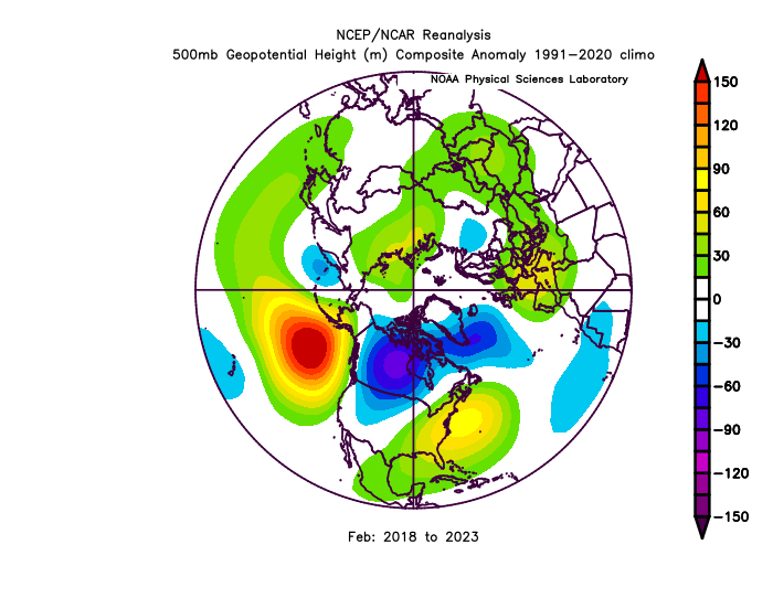
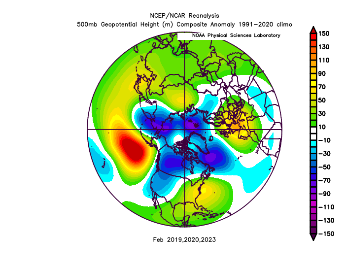
As far as long range forecasting goes, this is probably the most data I have seen supporting a favored atmospheric state 1+ month out. The Euro weeklies, ECMWF seasonal forecasting model, and other seasonal models all have a big +PNA (N. Pacific 500mb low) developing and sustaining for the month of February. For the last few decades, ENSO has correlated to the Global pattern, of all months of the year, the most in February. In La Nina's, we have seen a lot of -PNA's, and El Ninos, +PNA's during this month. The El Nino right now is in a "Strong" state, with Nino 3.4 sitting at +2.0c: It is actually the 7th total greatest ENSO event (all el nino's and la nina's) since 1948. My issue with +PNA February is we have seen a global state take over in the last 6 years. For a 6 year period, there is no other 500mb anomaly stronger than the -PNA we have seen from 2018-2023: The 2nd place 6-year running anomaly total only hits 0.80 correlation to ^this max. Now we have had more La Nina's over that 6-year period, but even our Neutral-El Nino Winter's have had a mean -PNA in recent February's: Which would you predict for February, a continuation of the recent ongoing years anomaly spike in the N. Pacific Ocean, or an El Nino driven +PNA (breaking the trend completely)? The CPC is going with a break, on a soft +PNA signal: https://ibb.co/dL4P5nW And long range 12z GEFS also has us going +PNA right now around Feb 1st. I think the patterns we have seen in December and January so far do not point to a big +PNA developing like seasonal models say, unless the El Nino all of a sudden wakes up, but it may be hard to sustain this -PNA pattern a 7th consecutive year. Should be interesting to see what happens. Any thoughts/analysis? I think if we don't do a -PNA in February, we'll do it in March.
-
El Nino 2023-2024
Stormchaserchuck1 replied to George001's topic in Weather Forecasting and Discussion
I've seen this plenty of time in the historical analysis - where a major 10mb warming occurs when the AO/NAO is ++. It still "downwells" to a strong -NAO correlation in 15-25 days! It's about 65-70% probability, which would put us at Feb 1-7. Current 15d models are already trying to shift the NAO back to Neutral. -
Jan Medium/Long Range Disco 2: Total Obliteration is Coming
Stormchaserchuck1 replied to Jebman's topic in Mid Atlantic
Yeah, that's weird that I have to wear a label. Don't get it.. I should complain like zywts. It's a shame, I have a lot to offer OT lol. -
Jan Medium/Long Range Disco 2: Total Obliteration is Coming
Stormchaserchuck1 replied to Jebman's topic in Mid Atlantic
New Euro gets DC up to 580dm Jan 23rd! 470'sdm over south Greenland, makes that a >100dm gradient/difference! CPC has the AO hitting +3 during that time. It doesn't look permanent though. -
Jan 15-16 Storm Thread 3: Obs and Disco
Stormchaserchuck1 replied to stormtracker's topic in Mid Atlantic
18z Hrr has 3" for NE MD.. this thing really trended north after us. storm is now suppose to snow to Toronto. -
Jan Medium/Long Range Disco 2: Total Obliteration is Coming
Stormchaserchuck1 replied to Jebman's topic in Mid Atlantic
These strong -WPO patterns usually flip. Here's the Jan 500mb regression correlation to WP-index https://ibb.co/WKJnvb1 See how it reverses over Alaska the next month https://ibb.co/tCJW8KT That's what we are seeing on models.. it maxes out near +600dm Jan 17-19 https://ibb.co/L5Bz98K Then it flips over AK Jan 22-24 https://ibb.co/WDSGf8Q It could really get warm when that happens.. it also looks like the +NAO is pulling from the depths of the Atlantic tropics, as like 50% of the Hemisphere is above average Jan 25-27. Ensemble mean has the 576dm line in DC Jan 23-25. -
Jan 15-16 Storm Threat Thread: The Return of Hope??
Stormchaserchuck1 replied to stormtracker's topic in Mid Atlantic
I think the trend toward a stronger system is a good trend, but short term models are sneaking a warm tongue in there and dryslot. Ideally, I think the heaviest precip should occur NW of the surface low, so I don't mind it wrapping up.. The global models are keeping precip closer to the surface low than the short term models are right now. -
Jan 15-16 Storm Threat Thread: The Return of Hope??
Stormchaserchuck1 replied to stormtracker's topic in Mid Atlantic
3z RAP really upped the totals from TN to WV.. north trend on this model -
Jan 15-16 Storm Threat Thread: The Return of Hope??
Stormchaserchuck1 replied to stormtracker's topic in Mid Atlantic
It's shifting NW/stronger vs 21z https://ibb.co/4JWmnr7 -
Jan 15-16 Storm Threat Thread: The Return of Hope??
Stormchaserchuck1 replied to stormtracker's topic in Mid Atlantic
02z RAP is shifting NW/stronger as well. -
Jan 15-16 Storm Threat Thread: The Return of Hope??
Stormchaserchuck1 replied to stormtracker's topic in Mid Atlantic
I like the maps just fine.. you can't see everything? They animate nicely. You can show me better maps if you want, but I like snow depth. -
Jan 15-16 Storm Threat Thread: The Return of Hope??
Stormchaserchuck1 replied to stormtracker's topic in Mid Atlantic
01z RAP is looking more impressive https://ibb.co/NK9x4N2 12" in TN -
Jan 15-16 Storm Threat Thread: The Return of Hope??
Stormchaserchuck1 replied to stormtracker's topic in Mid Atlantic
They will probably put WSWatches up north of Baltimore -
Jan 15-16 Storm Threat Thread: The Return of Hope??
Stormchaserchuck1 replied to stormtracker's topic in Mid Atlantic
It actually shows 2-4".. ratios have it changing over to ice briefly along I-95. -
Jan 15-16 Storm Threat Thread: The Return of Hope??
Stormchaserchuck1 replied to stormtracker's topic in Mid Atlantic
Stronger coastal https://ibb.co/SPJpBLm -
Jan 15-16 Storm Threat Thread: The Return of Hope??
Stormchaserchuck1 replied to stormtracker's topic in Mid Atlantic
Coastal low is further south on the NAM... keeps the precip going over the area -
Jan 15-16 Storm Threat Thread: The Return of Hope??
Stormchaserchuck1 replied to stormtracker's topic in Mid Atlantic
Shifted north a good bit https://ibb.co/F0pp2Kz -
Jan 15-16 Storm Threat Thread: The Return of Hope??
Stormchaserchuck1 replied to stormtracker's topic in Mid Atlantic
NW of NYC and SNE -
Jan 15-16 Storm Threat Thread: The Return of Hope??
Stormchaserchuck1 replied to stormtracker's topic in Mid Atlantic
Pretty big shift north in the NE actually.. similar to what the RAP did https://ibb.co/gM3BdR4 -
Jan 15-16 Storm Threat Thread: The Return of Hope??
Stormchaserchuck1 replied to stormtracker's topic in Mid Atlantic
Whole trough is more negative this run.. only slight differences with storm so far https://ibb.co/6Y3nDGG -
Jan 15-16 Storm Threat Thread: The Return of Hope??
Stormchaserchuck1 replied to stormtracker's topic in Mid Atlantic
0z Hrrr.. slight shift NW at hr20 https://ibb.co/QdBYr0w -
Jan 15-16 Storm Threat Thread: The Return of Hope??
Stormchaserchuck1 replied to stormtracker's topic in Mid Atlantic
I don't like big High pressures over the N. Pacific Ocean.. they correlate to snow here close to "0" -
Jan 15-16 Storm Threat Thread: The Return of Hope??
Stormchaserchuck1 replied to stormtracker's topic in Mid Atlantic
Gives part of WV 12-14".. we'll see


