TheClimateChanger
-
Posts
4,598 -
Joined
-
Last visited
Content Type
Profiles
Blogs
Forums
American Weather
Media Demo
Store
Gallery
Everything posted by TheClimateChanger
-
What I think is going on, and I don't say this lightly, is the climate has warmed so much already that typical weather events now seem unusual. Possibly even among people who accept the reality of global warming. I frequently see people claiming - without evidence, I might add - that global warming is actually leading to colder winter extremes, and wavier jet streams, and other similar nonsense. It's like these people have never looked at any historical weather records in their life. This is natural variability leading to regional cooling amidst a much, much warmer global climate. In colder past climates, there has been far colder weather. And snow was much more frequent along the Gulf of America (formerly known as the Gulf of Mexico) coast in the past than it is today.
-
A couple of examples, not even pointing to deniers, who deliberately do this. I saw a Univision meteorologist make a post on X showing a large chunk of the eastern United States as having a top 5 coldest January, including locations like Indianapolis and Miami. While the post did not label it as such, these appear to have been 21st century rankings. In fact, it was only the 36th coldest January on record at Indianapolis [and tied with 1962]. At Miami, it was the 43rd coldest January on record. It was, indeed, the 4th coldest January on record at Miami and Indianapolis, since 2000. Put in proper perspective, from 1896-1987, there were 39 colder Januarys at Miami! From 1875-1994, there were 33 Januarys as cold or colder than this one! That's a recurrence interval of only a bit fewer than 1 out of 2 years at Miami, and around 1 out of every 3.6 years at Indy, for those time periods [which encompass the late 19th century and the vast majority of the 20th century]. Not at all notable based on historical data. Another example... I saw the NWS Pittsburgh office share this on X. While it claims the data dates to 1871, in fact, snowfall depth data at Pittsburgh is only available since 1948. This means there have been 26 stretches with snowcover as long or longer than the stretch that recently ended during the preceding 77 years. That's more than 1 in every 3 years, so actually pretty typical. And, in fact, in not for the recent dearth of snow cover, the true incidence would be somewhat more frequent than implied by the full data. Also, some of those years in the 1970s & 1980s literally saw months of nonstop snowpack. It's also worth pointing out that snowfall observations are now taken in a shady, suburban office, which would be much more conducive to retention of snowpack than an open airfield with lots of tarmac. This suggests that there probably would have been even more streaks of a similar length if observations were taken at the same site. I don't know who needs to hear this, but there are supposed to be periods where snow lingers for weeks in a Pittsburgh winter. It's not at all unusual or noteworthy.
-
Maybe it's just me, but this seems emblematic of a bigger problem I see when it comes to cold temperatures and snowfall. There seems to be a push to exaggerate the importance of cold temperatures and/or snowfall, even when, from a historical perspective, they are normal conditions. Even model projections! I see people posting very long-range model projections of snow - 16 days, or even longer periods of 30+ days - and saying they've never seen such amounts of snow! I feel like I'm in bizarro world. Models do this all the time. Hell, there have been numerous periods where more snow than shown in those "unbelievable" projections actually fell! Not saying they are going to be right, but there have been, like, actual periods that were actually snowier than most of these maps I'm seeing.
-
On this point, I think it's worth noting that much hullabaloo has been made about this allegedly being the coldest January since 1988. We will have to wait and see what the NCEI numbers are, but UAH does not agree. Also, January 1988 is only the 24th coldest on record for the CONUS, so it's not notable at all. Even if this were to turn out to be the coldest January since 1988 for the CONUS, it's important to place this finding in perspective. From 1895-1988 - a period of 94 years - 24 years would have been colder than this January. In a typical 20th century climate, this means, on average, more than 1 out of every 4 Januarys would be expected to be colder than this one. And it's worth pointing out that the 20th century, from which this data is drawn, is widely regarded as being the warmest century in North America since the arrival of Europeans. While somewhat colder than the mean, this January was not atypically cold for the CONUS as a whole.
-
UAH is in and shows a pretty steep decline, albeit still a warm month. Not sure how much stock to place in their estimates. All adjustments ever made always seem to be downward! Their estimate for USA48 was -1.06C, making this the coldest January for USA48 since 2008.
-
I actually prefer the moniker, "The Best Location in the Nation. Cleveland, Ohio" as the great Bruce Kalinowski, then going by the name, Bruce Edwards, to survive in a vehemently anti-ethnic South, used to say. Bruce being well known from his days on The Weather Channel. Indeed, he was the live meteorologist for The Weather Channel's first ever broadcast way back in 1982.
-
Here is a live simulcast of the Zoom discussion on these findings:
-
-
Nice taste of spring today in the Ohio Valley, with some record highs being met or exceeded. Enjoy the warmth because it might be short-lived. I believe this is what they call "false spring" in these parts. As of the top of the hour, Columbus, Ohio was up to 63F, tying the record set on this date in 2020 and 1890; Dayton, Ohio was up to 65F, beating the prior record of 62F set in 2020 and 1927; Cincinnati, Ohio was up to 66F, tying the record set in 1883; Indianapolis, Indiana was up to 67F, tying the record set in 2020; South Bend, Indiana was up to 55F, tying the record set in 2020; Evansville, Indiana was up to 72F, breaking the record of 70F set in 2020; Paducah, Kentucky was up to 71F, tying the record set in 2020; Jackson, Kentucy was up to 70F, breaking the record of 69F set in 2020; and Lexington, Kentucky was up to 71F, breaking the record of 70F set in 1890. The temperature at Louisville stood at 73F, one shy of the 2020 record value. Any other record reports out there?
-
Pittsburgh/Western PA Winter 2024-2025 Thread
TheClimateChanger replied to Rd9108's topic in Upstate New York/Pennsylvania
Nice taste of spring today. 61F here. -
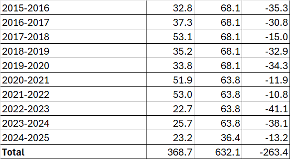
Using the full seasonal average of 63.8 inches for 2024-2025, a total of 659.5 inches should have fallen over this 10-year period. A positive departure of 263.4 inches means 922.9 inches would have fallen, or an average of 92.29 inches per year. So, a 10-year period with a similar positive departure would be a 10-year period where the average annual snowfall was between the value for the 4th & 5th snowiest individual winter on record in Cleveland.
-
The 10-year snowfall drought at Cleveland has reached an astounding deficit of 263.4 inches, or an average of 26.34 inches per year.
-
-
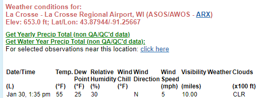
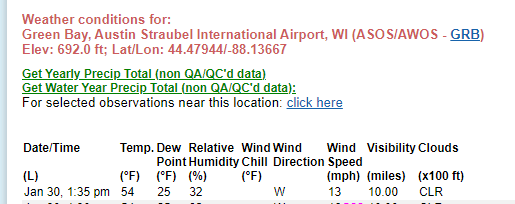
Don, one thing I have noticed is people hype up run-of-the-mill cold and then there is radio silence when actual historic warmth occurs. Current temperature at La Crosse, Wisconsin is 58F, setting a new January all-time record. The existing record of 57F was set on January 1, 1897; January 3, 1874; and January 25, 1981. That's right - a 151-year-old record. To put that into perspective, the American Revolution was less than 100 years old at the time, and the Civil War had ended about a decade prior. As Elon Musk might be inclined to say, let that sink in. Madison, Wisconsin is up to 57F, one shy of the all-time January monthly record of 58F set on January 6, 1880. Only one other January date has been so warm - January 3, 1874, when it also reached 57F. Elsewhere across the region, numerous daily records falling at long POR sites all across the Upper Midwest. Green Bay is also just a couple of degrees shy of its monthly record.
-
New January monthly record confirmed at La Crosse, with the temperature up to 58F as of the top of the hour, eclipsing the 151-year-old record. Overperforming at Madison, with the temperature now up to 57F, just one shy of the monthly record set in 1880.
-
3" of snow over 15 days at Pittsburgh from an ensemble mean, which is probably being affected by a few low-probability outliers. That's like 40% of normal. Not a very impressive snow signal IMHO.
-
Edit: Not sure what happened, but apparently the wrong values were showing when I first looked at it, maybe it didn't update or I clicked on the wrong location. The record at Madison is 58F from January 6, 1880, which I confirmed on ThreadEx. NowData looks correct when I checked again, so I'm not sure what I was looking at previously. Anyways, that one is probably safe, but still looking like a top 5-ish warmest January day at Madison, since 1869.
-
Temperatures continue to climb across the region, with locations such as Green Bay and La Crosse just a couple of degrees shy of all-time monthly record high temperatures. La Crosse, Wisconsin Green Bay, Wisconsin At Madison, the temperature has climbed to 54F. Allegedly, it reached 62F on January 26, 1944, but this seems dubious. The only other warmer January days at Madison were January 31, 1989 (56F), January 27, 2002 (55F) and January 24, 1981 (55F).
-
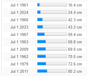
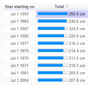
The site he links to can be expanded out to 1959-60. It gives this for the 10 least snowy winters, but the early data appears to be inaccurate. The value for 1961-62, in particular, appears implausibly low. The 10 snowiest winters are given below.
-
The all-time record for December at La Crosse is also quite recent, dating back to December 15, 2021, when the thermometer also reached 69F. So if the thermometer is able to crest this 57F hump, all three winter monthly record highs would have been set within the past 4 winters. It will certainly be a tall task, with the 57F record holding strong for an astounding 151 years, and only being able to be matched twice in that interval. To put this into perspective, the first time this record was set, it was less than 100 years from the American Revolution and only about a decade from the end of the U.S. Civil War!
-
As expected, the warmth has expanded over the Upper Midwest. As of shortly before noon local time, Madison and La Crosse were up to 50F, and Green Bay was at 46F, all of which are new daily records. The temperature at Rockford read 51F, one shy of the daily record. The all-time monthly record at La Crosse is 57F, set on January 1, 1897, January 3, 1874, and on January 25, 1981, which could be in jeopardy this afternoon. Of note, the all-time monthly record for February was set just last year, when the proverbial mercury reached a scorching 69F on February 27. Some would say that's a very nice number.
-
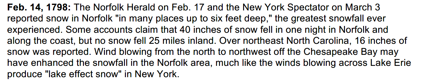
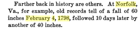
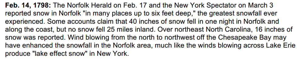
The winter of 1797-1798 must have pretty solid as well. Fine sleighing conditions, no doubt. The Tidewater Region probably had more snow in this 10-day stretch than they've had in the entire 21st century. Excerpt from "Why the Weather?" by Charles Frankin Brooks (1924). Some more details:
-
A couple others to look out for... forgot to check the NWS office in La Crosse, Wisconsin. La Crosse: 48F Forecast: 57F Rochester: 48F Forecast: 53F The forecast high of 57F at La Crosse would match the all-time January record.
-
Another round of near-record warmth is possible on Sunday, February 2nd, in some locations.
-
Widespread record-breaking warmth likely over the Upper Midwest tomorrow. The forecast high of 53F for GRB would obliterate the daily record by 11F, and come within 3F of the all-time January monthly record high. La Crosse, Wisconsin may reach 57F, which would match the all-time monthly high. Some records for 1/30 to keep an eye on, with forecast values in bold, for sites with long PORs: Minneapolis: 48F Forecast: 49F St. Cloud: 44F Forecast: 44F Eau Claire: 50F Forecast: 48F Madison: 47F Forecast: 54F Milwaukee: 53F Forecast: 54F Rockford: 52F Forecast: 54F Chicago: 55F Forecast: 53F Green Bay: 42F Forecast: 53F Wausau: 43F Forecast: 48F Rhinelander: 44F Forecast: 44F La Crosse: 48F Forecast: 57F Rochester: 48F Forecast: 53F