

TheClimateChanger
-
Posts
4,573 -
Joined
-
Last visited
Content Type
Profiles
Blogs
Forums
American Weather
Media Demo
Store
Gallery
Everything posted by TheClimateChanger
-
Record highs today at Pittsburgh (80F), Morgantown (83F), Wheeling (81F) and DuBois (76F).
-
Impressive. Wonder if we see our first 80F reading today?
-
I think we would be remiss to not also consider recent reduction in human aerosol emissions. I think most people think of aerosols as directly cooling the earth by absorbing and scattering sunlight. However, it should also be noted that these also provide cloud condensation nuclei which lead to thicker and brighter marine clouds. This effect may be as large, if not larger, than the direct effect.
-
84F, with Td of 13F, at top of the hour. Definitely a desert like airmass promoting large diurnal ranges. The current reading is 47F above the daily low. If not a "weathergami," it must be close.
-
Dust aloft can also inhibit instability by warming temperatures locally in the dust layer [absorbed solar radiation] and cooling temperatures at the surface [reduced solar radiation], similar to the conditions of the Dust Bowl or the Saharan Air Layer in the Tropical Atlantic.
-
80 right now at Charleston, W. Va., with 10% relative humidity. Edit: Actually 81F, and 9% humidity now!
-
In addition to temperatures in the mid to upper 70s today, gusty winds and very low relative humidities will promote an enhanced risk of wildfire spread today. A Red Flag Warning has been issued for parts of the region. Enjoy the exceptional early spring weather but take care if you are going to be around any open flames today and certainly hold off of burning any brush.
-
It looks like we should see our seventh day of 70+ this month today. We also have had a couple other days in the upper 60s. A 7th day would match 2012 for most through the first 19 days of March. Prior to 1990, there had never been more than 4, even including records from downtown. Can't complain. March has definitely come in as a benign lamb if you ignore the high winds and tornados.
-
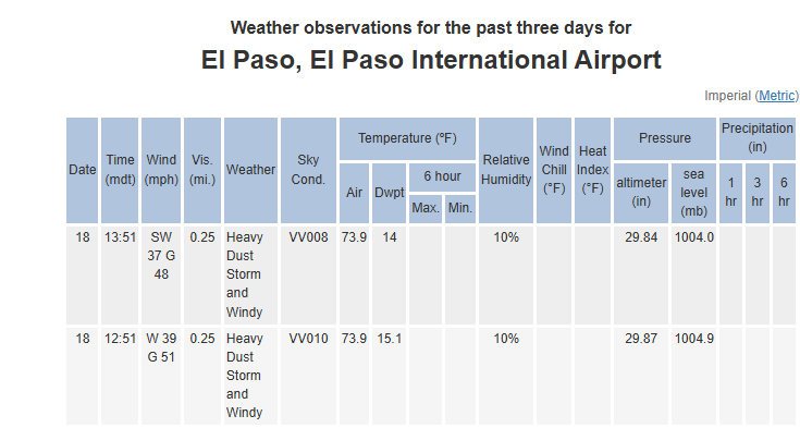
Wow, rough one across New Mexico and west Texas.
-
The first 17 days of March 2024 were a scorching blowtorch without precedence in the historical record. And it wasn't driven by minimum temperatures either. Mean maximum was more than 1F warmer than second place, and nearly 2.5F warmer than 1990 at Central Park.
-
I've been following this company on X. They are sending up balloons with sulfur. Of course, at this point, the amounts are orders of magnitudes too small to have any measurable impact on the climate. It's a great idea though. Maybe I need to find a partner?
-
Looks like we have a fifth tornado.
-
The comical thing is this only overlaps with 2 days from that Week 3-4 outlook that was showing a massive torch, and now they are saying the second half of March is going to be cooler. I can only surmise that CPC was expecting a cool start to March, followed by a much warmer second half?
-
They haven't done too well so far. The week 3-4 outlook you shared in late February has been much closer to the truth.
-
2024-2025 La Nina
TheClimateChanger replied to George001's topic in Weather Forecasting and Discussion
I hate that! A lot of TV meteorologists do that as well... de-emphasize the use of "normal" because they say it incorrectly implies other values are abnormal and instead use "average" or "mean." In fact, the NWS normals are not simple averages or means. In some cases, the two can be quite a bit different. There are adjustments for inhomogeneities [pairwise homogenization] and a lot of statistical work behind the scenes to smooth out the data, for instance. So, while calling them "averages" or "means" might be more intuitive for the casual weather viewer, it's not technically correct in the dictionary definition sense. -
2024-2025 La Nina
TheClimateChanger replied to George001's topic in Weather Forecasting and Discussion
The 1921-1950 normal at Detroit City Airport (no DTW) was 27.5F. Prior to that period, the "normals" published were just the means of all data from the city and airport. -
2024-2025 La Nina
TheClimateChanger replied to George001's topic in Weather Forecasting and Discussion
Normals are not simple averages. You are conflating the published normals with simple averages of data collected from different sites. The normals are - and always have been - corrected for biases and change in instrumentation, site location or other inhomogeneities. Here are two examples, but I'm sure the others are off as well. The 1931-1960 normal at DTW (as revised in 1967) was ~27.3F for the winter (DJF). Versus the corrected normal, this winter was approximately 0.2F above normal [not 0.4F below normal]. The 1941-1970 normal at DTW was ~26.6F for the winter (DJF). Versus the corrected normal, this winter was approximately 0.9F above normal [not 0.3F above normal]. -
A couple of tornado warnings now in effect east of Pittsburgh. In addition, a wind gust to 76 mph was recorded at Zanesville earlier, as well as a gust to 70 mph at Akron-Canton Airport.
-
-
The first 15 days of March have been very, with a mean of 58.3F - the 7th warmest on record. Last year saw the 2nd warmest period with a mean 3F warmer.
-
-
-
Records met or exceeded at all climate sites today, except DuBois. Low 80s common in the south and west parts of the CWA. PIT: 79F HLG: 81F MGW: 80F ZZV: 80F PHD: 78F
-
Definitely looking pretty intense in the Texas panhandle.
-


