TheClimateChanger
-
Posts
4,388 -
Joined
-
Last visited
Content Type
Profiles
Blogs
Forums
American Weather
Media Demo
Store
Gallery
Everything posted by TheClimateChanger
-
Hmm, while the statement will probably still be true, given the recent cooldown and continued cooler weather for the next several days, it now looks like there will be a pretty substantial warmup for the last few days of the month with a couple more days in the 70s looking probable.
-
Small hail and gusty winds again with the showers this afternoon.
-
Spring 2025 Medium/Long Range Discussion
TheClimateChanger replied to Chicago Storm's topic in Lakes/Ohio Valley
-
Occasional Thoughts on Climate Change
TheClimateChanger replied to donsutherland1's topic in Climate Change
Here's an interesting recent post on RealClimate: RealClimate: Andean glaciers have shrunk more than ever before in the entire Holocene -
A little glimpse into our collective future:
-
It sucks so bad that they are going to screw you out of record futility due to missing data from that winter. Absurd!
-
E PA/NJ/DE Spring 2025 Obs/Discussion
TheClimateChanger replied to PhiEaglesfan712's topic in Philadelphia Region
Just to show I'm not cherrypicking... here is Zanesville, Ohio. 20th driest stretch on record [of 130 years]. However, 6 of the years above it are missing more than two weeks of data. Excluding those years as highly suspect, it's 14th of 124 years with sufficient data. Note a bunch of other years with more rainfall are also missing data, but we know those years had more rainfall even despite the missing data. How can this justify a 4, yes 4, category drought improvement? IMO, the weekly Palmer indices are the better measure. -
E PA/NJ/DE Spring 2025 Obs/Discussion
TheClimateChanger replied to PhiEaglesfan712's topic in Philadelphia Region
This is all you need to know about how reliable NOAA is. The forecast called for heavy "La Nina" rains in the upper Ohio Valley. That didn't actually happen, but there was a miraculous 3 category drought improvement even though it the period from October 29 to the present has been much drier than normal. In fact, it was the driest on record [among years with complete data] at Wheeling, West Virginia. How does a drought improve by 3 categories during the driest stretch on record? I'm having trouble understanding how this is possible? October 29, 2024 March 18, 2025 -
Tornado confirmed yesterday at the Cincinnati-Northern Kentucky International Airport.
-
Fall/Winter '24 Banter and Complaints Go Here
TheClimateChanger replied to IWXwx's topic in Lakes/Ohio Valley
I previously looked into this. It has a small warm bias which peaks from May to July. Maybe on the order of about 0.4F or 0.5F warmer than the average of maximum and minimum, but reaching as much as 1F during the long day period (i.e., May & June). Keep in mind, this period predates even standardized time zones let alone daylight saving time. Time was measured in local solar time (LST), where noon equaled the time where the sun was at its peak in the sky directly overhead. For practicality, official time would be kept at one site for a city or region - perhaps a courthouse. Detroit, owing to its location in the western part of the eastern time zone, is offset about 40 minutes from solar noon under standard time, and 1 hour, 40 minutes under DST. So the morning observation would have been taken around 8:40 EDT, so it doesn’t do a good job capturing the morning low. The inclusion of a 9 pm observation (which would actually be as late as 10:40 EDT) helps to mitigate this somewhat but does not completely eliminate the warm bias. In the wintertime, the 7 am observation (~7:40 am EST at Detroit) is pretty close to sunrise and less biased. This is the main reason for the strong seasonal effect of the bias. The Smithsonian later changed the formula to double weight the 9 pm observation around 1870. So it became the average of 7, 2, 9, 9, which is much closer to max + min / 2, but still has a small residual warm bias by my reckoning. Note, however, that observations weren’t always made by that standard. Sometimes only two observations were made. Sometimes, the observations were sunrise, 2, and 9 which would do a much better job of capturing the minimum. This formula would probably even have a cool bias relative to max + min / 2. However, it wasn’t as common as the other. Sometimes, the morning observation was taken even later. -
Only lasted like 5 minutes, not the hail, the entire rain shower. The hail & wind was only like 30 seconds. Actually clearing up now.
-
Small hail and gusty winds with the showers right now.
-
This setup looks promising. Still favoring somewhat wetter than normal conditions along the east coast, but plenty of above normal conditions from coast to coast, and an expansive area of below normal precipitation favored across much of the country.
-
Maybe a little early to talk about, but summer looking solid. Looking high and dry for many on today's update.
-
Today might wind up as the high water mark for March temperatures. Current forecast has many days in the 40s or low 50s for the remainder of the month.
-
-
Record highs today at Pittsburgh (80F), Morgantown (83F), Wheeling (81F) and DuBois (76F).
-
Impressive. Wonder if we see our first 80F reading today?
-
I think we would be remiss to not also consider recent reduction in human aerosol emissions. I think most people think of aerosols as directly cooling the earth by absorbing and scattering sunlight. However, it should also be noted that these also provide cloud condensation nuclei which lead to thicker and brighter marine clouds. This effect may be as large, if not larger, than the direct effect.
-
84F, with Td of 13F, at top of the hour. Definitely a desert like airmass promoting large diurnal ranges. The current reading is 47F above the daily low. If not a "weathergami," it must be close.
-
Dust aloft can also inhibit instability by warming temperatures locally in the dust layer [absorbed solar radiation] and cooling temperatures at the surface [reduced solar radiation], similar to the conditions of the Dust Bowl or the Saharan Air Layer in the Tropical Atlantic.
-
80 right now at Charleston, W. Va., with 10% relative humidity. Edit: Actually 81F, and 9% humidity now!
-
In addition to temperatures in the mid to upper 70s today, gusty winds and very low relative humidities will promote an enhanced risk of wildfire spread today. A Red Flag Warning has been issued for parts of the region. Enjoy the exceptional early spring weather but take care if you are going to be around any open flames today and certainly hold off of burning any brush.
-
It looks like we should see our seventh day of 70+ this month today. We also have had a couple other days in the upper 60s. A 7th day would match 2012 for most through the first 19 days of March. Prior to 1990, there had never been more than 4, even including records from downtown. Can't complain. March has definitely come in as a benign lamb if you ignore the high winds and tornados.
-
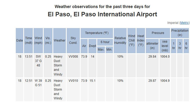
Wow, rough one across New Mexico and west Texas.