TheClimateChanger
-
Posts
4,574 -
Joined
-
Last visited
Content Type
Profiles
Blogs
Forums
American Weather
Media Demo
Store
Gallery
Everything posted by TheClimateChanger
-
Occasional Thoughts on Climate Change
TheClimateChanger replied to donsutherland1's topic in Climate Change
The bottom line is this: Even if daytime maxima have decreased slightly in the Corn Belt, humidity has increased substantially moreso. So cooler temperatures should not be read as milder. There has clearly been an increase in the incidence of dangerously high heat indices. -
Occasional Thoughts on Climate Change
TheClimateChanger replied to donsutherland1's topic in Climate Change
Like the deniers always say, cherrypicked. Everybody knows the 1950s had a lot of hot summers. These statements also never account for humidity. The driest July on record in Des Moines was in 1936 (see below), which is also the hottest on record. Remarkably, the average dewpoint was even lower than the very chilly July of 2009, which had the lowest mean dewpoint of any recent years! In fact, if you look at the highest hourly heat indices on record, you will see they were mostly set just last summer. There was nothing remotely similar to the deadly combination of heat and humidity that occurred last summer during the Dust Bowl. I don't think people realize that, without widespread air conditioning, thousands of people would die each and every summer these days. In sum, there is no evidence for milder summers in the midwest; rather, dangerous heat and humidity has been on the increase in recent decades. Note - the 122F from 1936 appears to be erroneous. No other hourly heat index that day was anywhere near that measurement. Appears to be a spuriously high dewpoint reading. Regardless, 8 of the 24 highest hourly heat indices on record in Des Moines were established just last summer. Almost all of the record readings are from this century.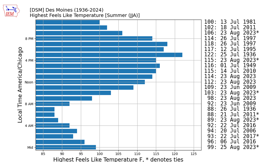
-
Pittsburgh/Western PA Spring 2024
TheClimateChanger replied to Ahoff's topic in Upstate New York/Pennsylvania
Accuweather suggesting we could approach a record high this afternoon. Yinz stay cool aht thar.
-
Pittsburgh/Western PA Spring 2024
TheClimateChanger replied to Ahoff's topic in Upstate New York/Pennsylvania
I think my station runs a little high on the rooftop on sunny days, and also radiates much better than PIT, so it was probably somewhat exaggerated. Looking at 5-minute ASOS observations, looks like falls of 4-6F were common along and near totality. It did drop back to 70F at PIT later in the eclipse, from 71/72F before recovering to 74F. -
Pittsburgh/Western PA Spring 2024
TheClimateChanger replied to Ahoff's topic in Upstate New York/Pennsylvania
Anyways, certainly looks like April will be another above normal month. Currently, sitting at +2.6F. Looking at the extended outlook, I think we're likely to wind up closer to +5F than to normal. -
Pittsburgh/Western PA Spring 2024
TheClimateChanger replied to Ahoff's topic in Upstate New York/Pennsylvania
My weather station showed a drop of nearly 8F, with solar radiation plunging to less than 5 W/m^2. -
April 8 Great American Eclipse forecast
TheClimateChanger replied to DLMKA's topic in Lakes/Ohio Valley
My weather station dropped by nearly 8F and wasn’t even in totality. -
April 8 Great American Eclipse forecast
TheClimateChanger replied to DLMKA's topic in Lakes/Ohio Valley
Surprisingly pricy though. -
Pittsburgh/Western PA Spring 2024
TheClimateChanger replied to Ahoff's topic in Upstate New York/Pennsylvania
Did y’ins catch a glimpse of the sun today? -
Pittsburgh/Western PA Spring 2024
TheClimateChanger replied to Ahoff's topic in Upstate New York/Pennsylvania
-
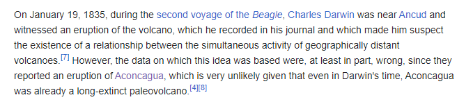
Interestingly, Volcano Osorno apparently erupted in Chile one day prior to the big Cosiguina eruption in Nicaragua. Charles Darwin also believed there was an eruption of Aconcagua, but that's an extinct paleovolcano. Perhaps there was a third eruption in Argentina? Or he just lost his bearings and actually witnessed the eruptions of Osorno and Cosiguina?
-
That 47.6F in 1836 is very interesting. I've read in numerous sources of a "great refrigeration" that occurred from about 1835-1838 on par with that of 1816. There was reportedly 2" of snow in Guangzhou [Canton], China in February 1835, suggesting it very well could have been a global [or at least hemisphere-wide] phenomenon. Berkeley Earth blames it on Cosiguina, which erupted in January 1835, and says there was a global land average temperature drop of 0.75C. However, it doesn't seem strong enough to me for that degree of response. Cosigüina - Wikipedia
-
On average, I think we can surmise that the mid 19th century climate of New York would have been comparable to that of present-day Albany, about 135 miles to the north (according to Wikipedia). It's still slightly warmer than recent years at KALB, but the airport is at nearly 300' elevation, while the bulk of the city of Albany is only around 100' elevation.
-
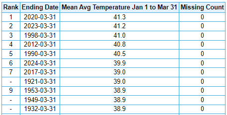
Good post, Don. Even more striking when you look at the values observed by the U.S. Army Signal Corps at Fort Columbus [later known as Fort Jay] on Governor's Island, south of Manhattan, from 1821-1854. In that stretch of 34 Decembers, only 2 had a mean temperature in excess of the current normal (41.3, 1829; and 40.4F, 1852). One other year (1848) had a mean right on par with the current normal of 39.3F. While the proximity to water could lead to some cooling in the spring and summer, relative to Central Park, I would assume the proximity to water would lead this site to be warmer in the cold season.
-
Pittsburgh/Western PA Spring 2024
TheClimateChanger replied to Ahoff's topic in Upstate New York/Pennsylvania
Looks like the highest crest since January 2005. -
Pittsburgh/Western PA Spring 2024
TheClimateChanger replied to Ahoff's topic in Upstate New York/Pennsylvania
-
Pittsburgh/Western PA Spring 2024
TheClimateChanger replied to Ahoff's topic in Upstate New York/Pennsylvania
-
4/2-4/3 Significant Late-Season Snowstorm (WI/MI)
TheClimateChanger replied to Geoboy645's topic in Lakes/Ohio Valley
What a clown. There's like half an inch in Marquette. Maybe a couple feet well inland, but not in the city. -
Central Pa. Spring 2024
TheClimateChanger replied to mahantango#1's topic in Upstate New York/Pennsylvania
Also [through yesterday], this has been the 4th wettest start to the year at Williamsport and 5th at Harrisburg. 2024 is certainly holding its own in the annals of weather history. -
Pittsburgh/Western PA Spring 2024
TheClimateChanger replied to Ahoff's topic in Upstate New York/Pennsylvania
Very impressive. 4th warmest and 2nd wettest YTD in the threaded record, and winter season snowfall currently sitting at 6th least on record. -
4/1-4/2 severe threat (southern portion of subforum)
TheClimateChanger replied to largetornado's topic in Lakes/Ohio Valley
-
Pittsburgh/Western PA Spring 2024
TheClimateChanger replied to Ahoff's topic in Upstate New York/Pennsylvania
-
Central Pa. Spring 2024
TheClimateChanger replied to mahantango#1's topic in Upstate New York/Pennsylvania
Below normal? I wish. Not so here. -
Central Pa. Spring 2024
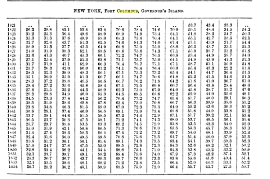
TheClimateChanger replied to mahantango#1's topic in Upstate New York/Pennsylvania
As we round out the first quarter of 2024, I thought it might be a good time for a review of temperatures. Through the first quarter of 2024, it's been quite toasty in central Pennsylvania. Williamsport: Third warmest start to the year [of 130 years], behind 2012 & 2023. Harrisburg / Middletown: Sixth warmest start to the year [of 136 years], behind 2020, 2023, 1998, 2012 & 1990.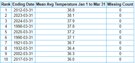
-
Pittsburgh/Western PA Spring 2024
TheClimateChanger replied to Ahoff's topic in Upstate New York/Pennsylvania
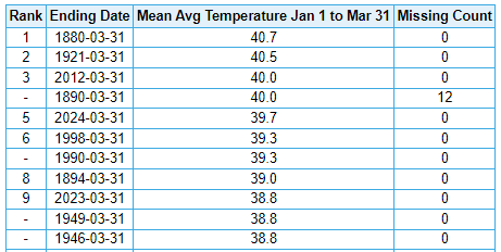
Not to change the subject from the potential severe weather, but a quick climate glance for the first quarter of 2024 [through 3/31]. The average mean temperature for the first 1/4 of the year has been 39.7F, placing it in 5th place in the threaded record. Note, however, that 1890 [0.3F warmer] has 12 missing days, so it very well might be lower than this year if not for the missing data. Second warmest start to the year at the airport behind 2012. Last year had the 8th warmest first three months, now dropped back to 9th place in the threaded record.