TheClimateChanger
Members-
Posts
4,472 -
Joined
-
Last visited
Content Type
Profiles
Blogs
Forums
American Weather
Media Demo
Store
Gallery
Everything posted by TheClimateChanger
-
Pittsburgh/Western PA Spring 2024
TheClimateChanger replied to Ahoff's topic in Upstate New York/Pennsylvania
-
Pittsburgh/Western PA Spring 2024
TheClimateChanger replied to Ahoff's topic in Upstate New York/Pennsylvania
Looks like we are going to struggle to get many 90s again. My weather station was from 1.5-2F cooler than the airport, but now since the sun came out and spring has arrived, it's 2-4F warmer during the afternoon. Still cooler at night though. -
To highlight how profound this impact is, if we look at the first 34 years of data collected at the Michigan State Agricultural College [now Michigan State University], the mean minima in the month of March was 18.7F. The mean low temperature of the most recent 14 Marches observed at Capital City Airport is 26.8F. Further, the mean monthly minima for the month of January and February over the past 15 years is 18.2F and 18.3F, respectively. Or only slightly less than the 19th century March average.
-
Also, I find it rather presumptuous that you think I was trying to ameliorate a growing UHI effect. I was just trying to eliminate as much urban heat island contamination, regardless of when it occurred. Most of this is comparing data collected from rooftop and/or north-facing window enclosures in the city center to modern data collected from suburban airport sites with equipment properly installed at an appropriate height over grass or sod. The low temperatures in the early data are more impacted by this, and therefore show less warming at most of the sites. We can see one exception to this is the data for East Lansing, where minima have increased by an astounding 8.1F in the month of March when comparing the first 34 years of data to the most recent 14 years. This is likely due to the fact that the temperature shelter was properly housed over grass or sod, and East Lansing was still very rural [especially in 1863, when the data starts].
-
One interesting thing is the mean high temperature in April during the 19th century was closer to recent March high temperatures than the 19th century March figures at many sites. That's the case at Milwaukee, Chicago, Cleveland, Washington, New York, Philadelphia, Atlanta and Charlotte. Detroit is a push. I think that's consistent with about a 2-3 week seasonal shift forward, which I think is also supported by phenological data. March in the 19th century had a climate we associate with the period of mid February through early March. March today is more akin to the period from mid March through early April from the 19th century.
-
Winter '23-'24 Piss and Moan/Banter Thread
TheClimateChanger replied to IWXwx's topic in Lakes/Ohio Valley
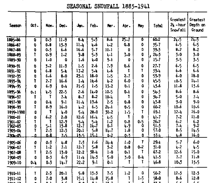
Both of those were at lakeside observatories on a rooftop. C'mon man, you would have loved this. These are the glory days for Detroit. In the modern threaded record, there are only 15 years that had a peak snow depth of 12" or more at Detroit [out of 77 years]. The maximum is 24" from the winter of 1998-1999. From 1885-1886 to 1911-12 (rounding to the nearest inch), the following peak depths were noted: (1) 26" in 1899-1900 (2) 25" in 1885-1886 [in April, no less!] (3) 18" in 1892-1893 (4) 16" in 1904-1905 (5) 15" in 1907-1908 (6) 15" in 1903-1904 (7) 14" in 1893-1894 (8) 14" in 1894-1895 (9) 14" in 1909-1910 (10) 13" in 1911-1912 (11) 12" in 1910-1911 (12) 12" in 1908-1909 (13) 11" in 1900-1901 (14) 11" in 1898-1899 That's 12 years with 12"+ more peak depth, and 14 with 11" or more, in just 27 winters, compared to 15 & 18 in 77 winters with daily snow depth data - including two years with peak depths higher than any observed in the most recent 77 winters. Look at the 24 hour snowfalls - at least 8 double digit snowfalls [possible additional ones, since I didn't check], including 4 years with 12"+ [and a fifth at 11.8"] with one having observed more than 24" in a 24 hour period. This is clearly a higher frequency of big storms and deep snow depth than recent decades. -
March 2024 General Discussion
TheClimateChanger replied to MazooWeather's topic in Lakes/Ohio Valley
Looks like another new record. Was 71 at the top of last hour at MSP. -
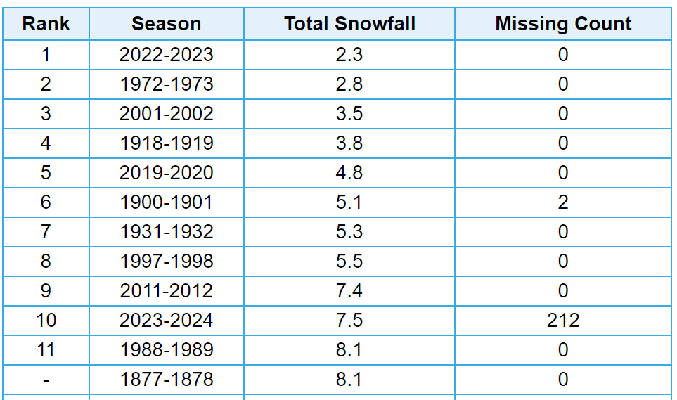
Will be interesting to see whether New York City observes any more snowfall this winter. Currently, ninth least for the season dating back to the winter of 1868-1869. Only partial records available for the first winter, but there was still far more snowfall observed in the available months. xMacis has this as 10th least; however, there was actually 9.1" observed in the winter of 1900-1901. xMacis is missing 4 inches from that winter.
-
Winter '23-'24 Piss and Moan/Banter Thread
TheClimateChanger replied to IWXwx's topic in Lakes/Ohio Valley
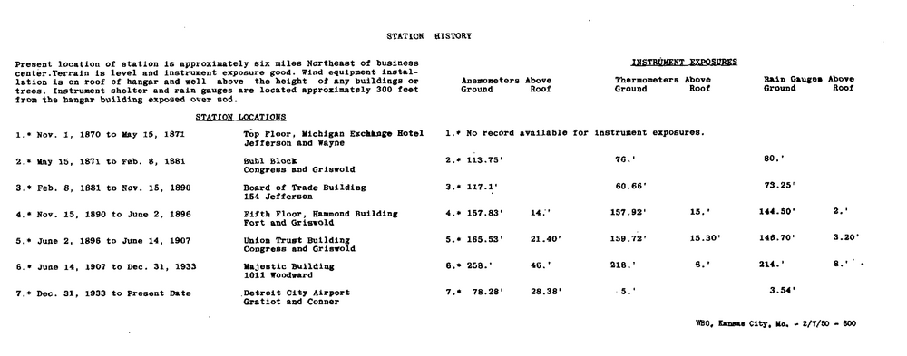
The point is we are comparing temperatures collected over grass or sod from modern aspirated temperature sensors to mercury thermometers housed in shelters in a window enclosure or on rooftops. Obviously, it would be substantially warmer if the official observation was still taken downtown on a rooftop. And then we have people in this thread lying about there being LESS UHI in 1930. The population of Detroit was 1.6 million in 1930, and the official observation site was on the rooftop of the Majestic Building downtown at 1011 Woodward. All I'm doing is providing actual data... it was indeed the warmest on record at DET back to 1933-1934 and at DTW back to 1958-1959, as well as the fourth warmest in the threaded record back to 1874 [1870-1871, if you include the tri-daily means pre-1874], while also providing useful information about the historic location and exposure of the official station in the threaded record, and countering disinformation. Station history from 1949 annual publication: Useful information on impacts of rooftop exposure versus sod/grass: How not to measure temperature, part 48. NOAA cites errors with Baltimore's Rooftop USHCN Station – Watts Up With That? -
Winter '23-'24 Piss and Moan/Banter Thread
TheClimateChanger replied to IWXwx's topic in Lakes/Ohio Valley
I’m talking about the city office records, which were indeed a north-facing window exposure for the first several years, and rooftop exposure thereafter. -
Warmest February on record in UAH at +0.93C. Also ties October 2023 for highest anomaly of any month. https://www.drroyspencer.com
-
-
Winter '23-'24 Piss and Moan/Banter Thread
TheClimateChanger replied to IWXwx's topic in Lakes/Ohio Valley
Difficult to unseat those historic downtown city office readings with a sub-standard north-facing window or rooftop exposure for the instrument shelter, and the enhanced UHI and proximity to the river. But fourth place is still quite impressive. Warmest since 1931-1932 officially. -
Winter '23-'24 Piss and Moan/Banter Thread
TheClimateChanger replied to IWXwx's topic in Lakes/Ohio Valley
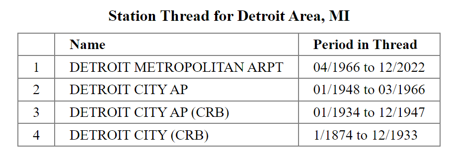
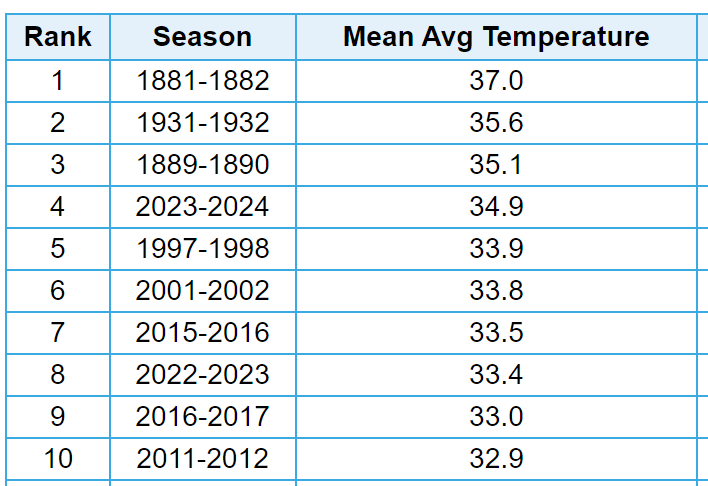
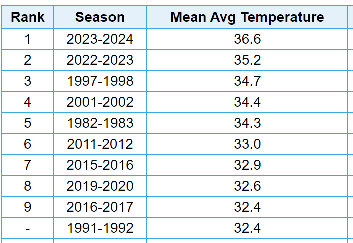
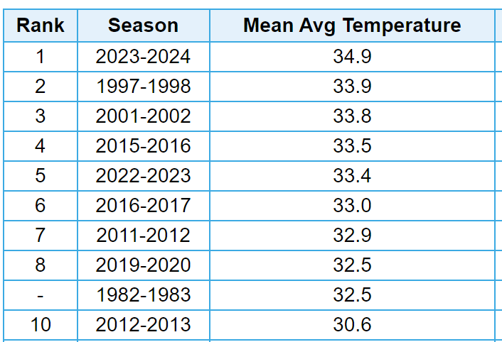
With meteorological winter in the books, here is how things shaped up in southeast Michigan. It was the fourth warmest in the threaded record (dating to 1874-1875). It was the warmest on record at Detroit City Airport (dating to 1933-1934) and the warmest on record at Detroit Metropolitan Wayne Airport (dating to 1958-1959). Interestingly, the 36.6F mean temperature at DET [which was the official observation site from 1934-1966] would have placed second warmest in the threaded record. Last winter's value of 35.2F would have placed third [or fourth if you also included this winter]. The station thread is as follows: Threaded record City Airport Detroit Metropolitan Wayne International Airport -
March 2024 General Discussion
TheClimateChanger replied to MazooWeather's topic in Lakes/Ohio Valley
Have to wonder if we will see a repeat of these apparent temperatures this coming summer in the Midwest. 19 hours of 110+ heat indices last summer in Des Moines, beating the previous record of 13 hours from 1995, 2010, and 2011. The hottest summer on record in Des Moines (1936) had just two hours. Not quite as impressive with 105F+ heat index hours, but still tied with 1936 & 2012. And behind only 1980, 1983, 1988 and 2011. -
Looks like Detroit will finish with a mean of 37.1F, good for third warmest February on record. In addition to the monthly maximum record of 73F on the 27th, the low of 49F on the 9th tied for warmest minimum of record in the month of February [previously set on February 20, 2018].
-
If the media covered the recent heat in Michigan the same way. Crowds converged on Grand Haven beach to escape the searing sun. Butterflies spotted in Gaylord. Two heat prostrations in Detroit. Auto industry closed up shop and evacuated its plants. A thermometer in the sun somewhere registered 85 degrees. But bundle up because a blizzard is hitting tomorrow.
-
Pittsburgh/Western PA Spring 2024
TheClimateChanger replied to Ahoff's topic in Upstate New York/Pennsylvania
Make that 4 out of 8. Looks like we'll come in at 39.5F, 0.1F above the 1961-1990 mean for the month of March. -
This is kind of nonsense I'm talking about... January 22, 1906 headline of the NY Times "Winter Heat Wave Sends Crowd to Coney Island" - the high was 60F in New York City that day. But apparently crowds were flocking to the beach to beat the heat. The story continues on Page 2 talking about caterpillars dropping from trees and butterflies flying around in Rutland, Vermont. Here's the story from Pittsburgh [then Pittsburg] from the NY Times: Oh no! It was 74F on top of the hot roof of the Farmers National Bank Building - that's a 344' skyscraper that was tore down in 1997 BTW. But urban heat island effect didn't exist in 1906! Lol. Anyways, the absurdity of this is hilarious. A "heat prostration" in January - why didn't the guy take off his winter coat? And why were steel and glass mills shutting down? How the heck did they operate in the summer? Oh, and some things never change - that blizzard the Weather Bureau forecast, yeah that didn't happen. It apparently was a blizzard in the middle of the country with temperatures as low as -16F in Missouri though.
-
Pittsburgh, Pa Winter 2023-24 Thread.
TheClimateChanger replied to meatwad's topic in Upstate New York/Pennsylvania
Through yesterday, this was the fourth warmest February by mean temperature in the threaded record, exceeding last year by 0.1F. By high temperature - which I feel somewhat ameliorates the impact from the downtown site - it was tied for fourth warmest with 2017. Last year was second warmest by that metric (which also means this year would have been third prior to last year). -
https://www.weather.gov/pbz/svrclimo
-
EF-2 confirmed in Monroe County, Ohio. That was the first recorded tornado in Monroe County since June 22, 1990, and only the 3rd of record since 1950. It was also the strongest of record, exceeding an F-1 in 1969.
-
It made it up to 73F as far north as Traverse City, Michigan, which exceeded the prior monthly record by 7F. Prior to this year, it had only reached 60 or better in February in 4 years (1984, 1999, 2000, and 2017) since 1896, and only exceeded 60 in two of those years (2000 & 2017). Absurd, especially considering the identical 73F reading at Toledo was also a monthly record, and the Michigan statewide record was 72F from 1999.


