TheClimateChanger
Members-
Posts
1,815 -
Joined
-
Last visited
Content Type
Profiles
Blogs
Forums
American Weather
Media Demo
Store
Gallery
Everything posted by TheClimateChanger
-
Winter '23-'24 Piss and Moan/Banter Thread
TheClimateChanger replied to IWXwx's topic in Lakes/Ohio Valley
Weird. Great Lakes are supposed to keep things cold enough to prevent premature blooming before the last killing frost of spring. That's why there are so many orchards here, despite the latitude. -
Pittsburgh, Pa Winter 2023-24 Thread.
TheClimateChanger replied to meatwad's topic in Upstate New York/Pennsylvania
-
Winter 2023/24 Medium/Long Range Discussion
TheClimateChanger replied to Chicago Storm's topic in Lakes/Ohio Valley
-
Pittsburgh, Pa Winter 2023-24 Thread.
TheClimateChanger replied to meatwad's topic in Upstate New York/Pennsylvania
-
Central PA Winter 23/24
TheClimateChanger replied to Voyager's topic in Upstate New York/Pennsylvania
-
Interesting. Using 1981-2010 normals for winter of 2019-2020, and 1991-2020 normals for all other years [including retroactively applying them to the entire winter of 2020-2021], with to date values used for 2023-2024, I computed the following running 5-year cumulative deficits for CLE's CWA: Cleveland: -122.6" [181.2" observed versus 303.8" normal] Mansfield: -120.3" [110.5" observed versus 230.8" normal] Akron-Canton: -59.3" [163.1" observed versus 222.4" normal] Toledo: -55.5" [120.3" observed versus 175.8" normal] Youngstown: -98.6" [216.4" observed versus 315.0" normal] Erie: -226.3" [267.6" observed versus 493.9" normal] Looks like by the end of the winter, the 5-year deficit should range from 5-10 feet below normal areawide.
-
Pittsburgh, Pa Winter 2023-24 Thread.
TheClimateChanger replied to meatwad's topic in Upstate New York/Pennsylvania
Picked up another 0.8” overnight, for a storm total of 3.6” -
Pittsburgh, Pa Winter 2023-24 Thread.
TheClimateChanger replied to meatwad's topic in Upstate New York/Pennsylvania
Looks like the official daily total came in at 3.3”. -
Let’s talk winter!! Ohio and surrounding states!!
TheClimateChanger replied to Steve's topic in Lakes/Ohio Valley
Totals approaching a foot in parts of eastern Ohio. -
Pittsburgh, Pa Winter 2023-24 Thread.
TheClimateChanger replied to meatwad's topic in Upstate New York/Pennsylvania
2.8” here so far. -
Let’s talk winter!! Ohio and surrounding states!!
TheClimateChanger replied to Steve's topic in Lakes/Ohio Valley
Looks like some 7 to 10 inch totals in parts of east central Ohio. -
Pittsburgh, Pa Winter 2023-24 Thread.
TheClimateChanger replied to meatwad's topic in Upstate New York/Pennsylvania
9.5” report from Hopedale, Ohio. -
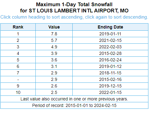
Incredible. Looks like it will be one of the top 10 daily snowfalls to have occurred in the last 10 years.
-
Winter '23-'24 Piss and Moan/Banter Thread
TheClimateChanger replied to IWXwx's topic in Lakes/Ohio Valley
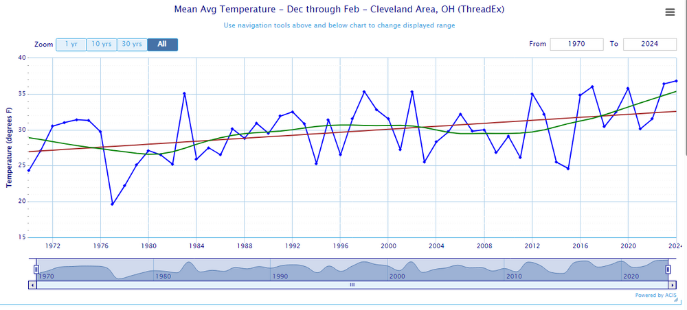
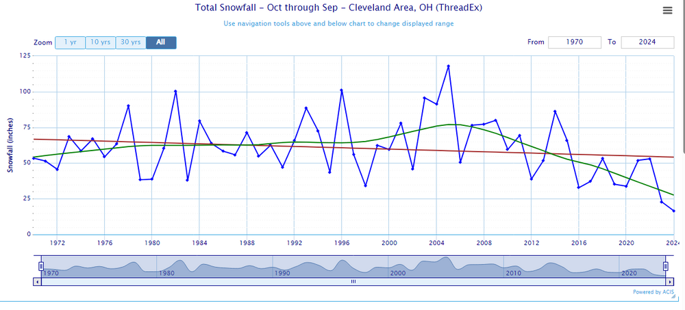
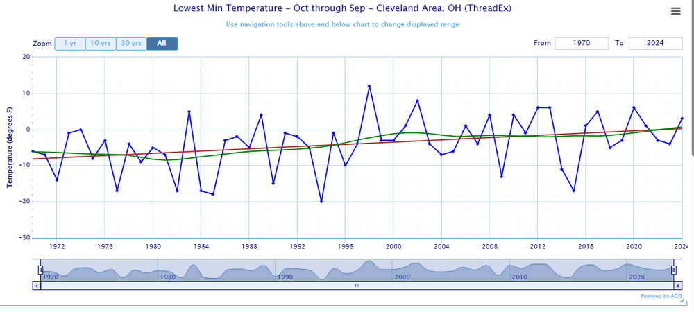
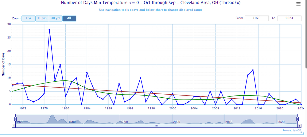
Documenting the loss of winter with true & accurate data: Temperature Predicted Value, 1970 (linear): 26.9F Predicted Value, 2024 (linear): 32.6F Difference: +5.8F LOESS curve has a predicted value of 35.3F for 2024. Snowfall Predicted value, 1970 (linear): 66.8" Predicted value, 2024 (linear): 54.2" LOESS Curve appears to do a much better job at capturing the trends - current predicted value: 27.6". Look at that insane inflection point at 2005! Annual Minimum Temperature Predicted value, 1970 (linear): -8F Predicted value, 2024 (linear): 0F From solidly Zone 6a to borderline Zone 7a. Number of Days at or below Zero Predicted value, 1970 (linear): 7 Predicted value, 2024 (linear): 1 [LOESS curve predicts fewer than 0] -
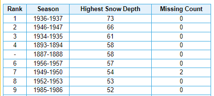
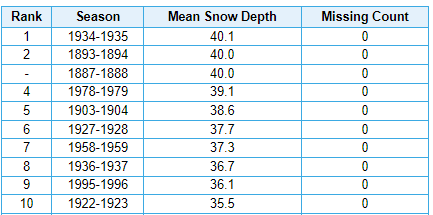
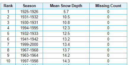
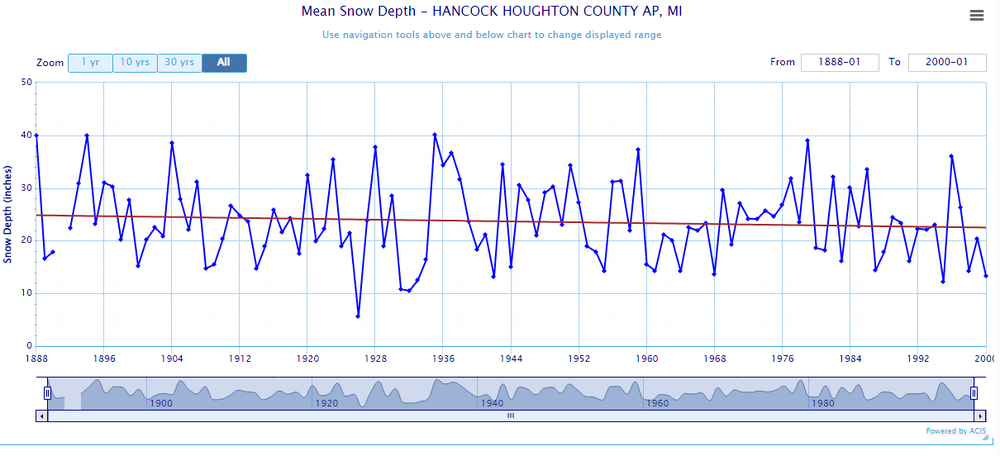
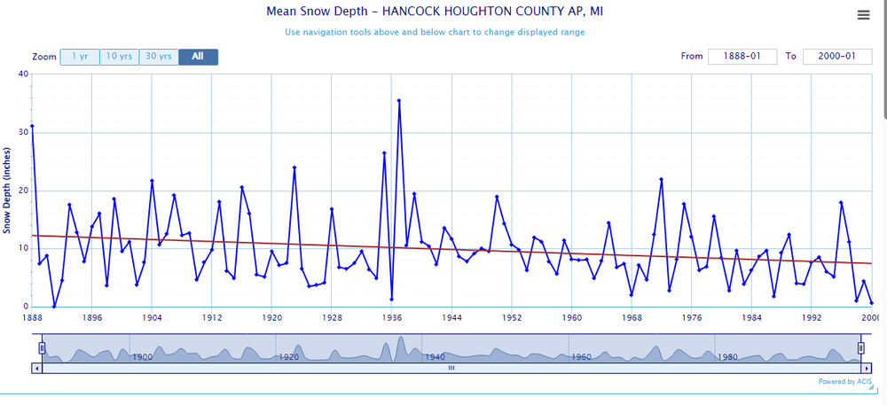
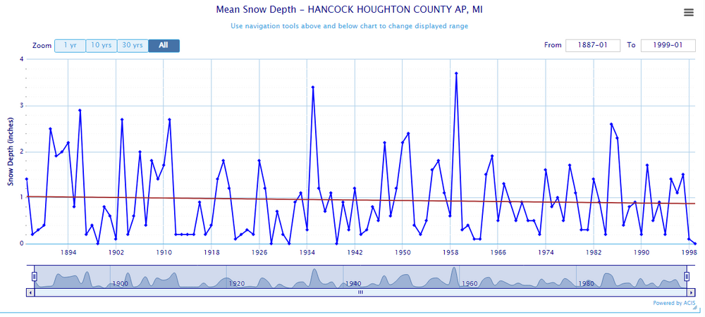
Not surprised. Weather in the UP is often wildly different from the lower Great Lakes. The high-water mark for snow depth in the CMX station thread was the winter of 1936-37, which was the least snowy on record at Detroit. Maximum Winter Season Snow Depth (1888-2000) Mean Winter Season Snow Depth (1888-2000) - sorted by highest. Some of those winters that don't look very impressive in recorded snowfall totals in the 1920s and 1930s, nevertheless resulted in very high snow depths. It is true, however, that most of those low snowfall years were quite bad for snow depth, particularly 1925-1926, which apparently was the polar opposite of 1936-37.
-
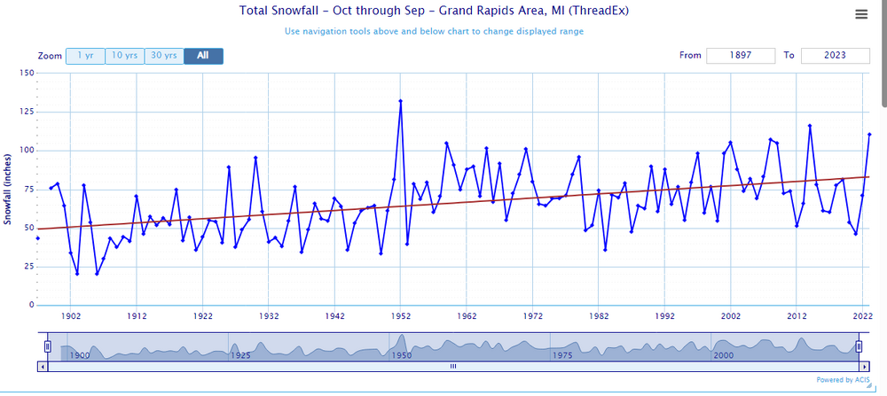
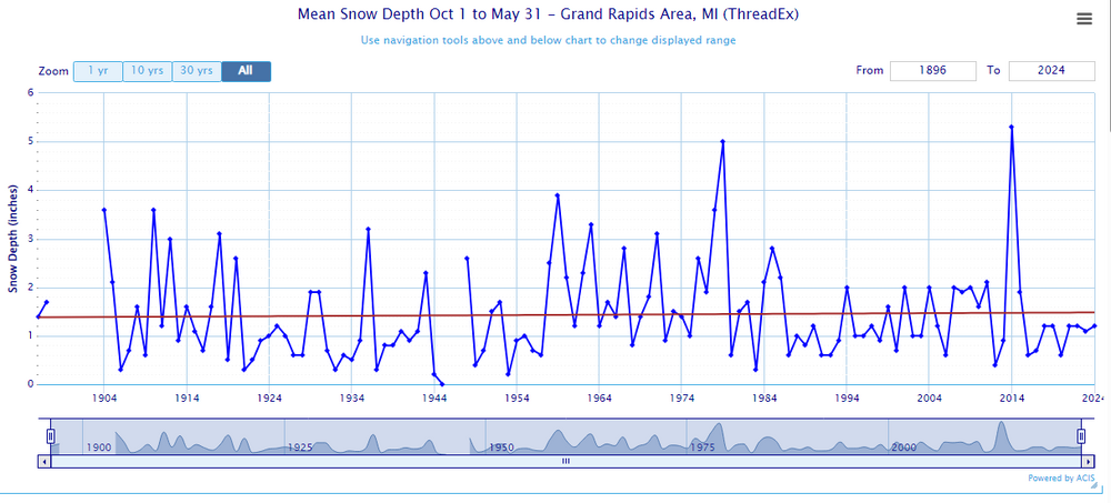
Same with GRR. Mean snow depth no trend (less than 0.1" increase) over POR, yet regression shows 33" increase in yearly snowfall. Of course, no change since 1950, when snowfall measurements became more standardized.
-
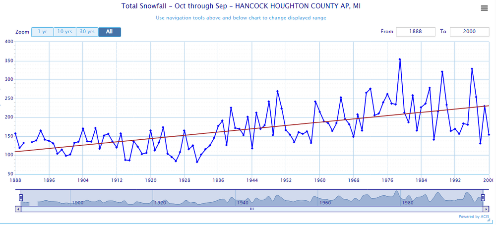
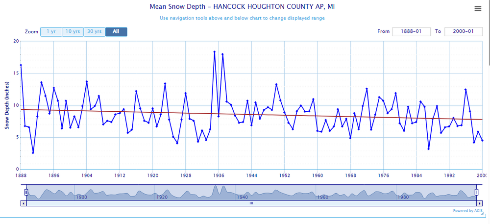
I mean this is a little suspect, no? Ends in 2000, but you get the point... snow depth trend would probably be more pronounced if there were still observations at the airport. Somehow snow depth was higher 100+ years ago, despite snowfall being 50% of recent decades. If average seasonal snowfall doubled, why has mean snow depth decreased if every season? Certainly, the temperatures have warmed somewhat, but it's still mainly below freezing in Keweenaw. Mean Snow Depth (Winter) Mean Snow Depth (Spring) Mean Snow Depth (Fall) Mean Snow Depth (Annual)
-
-
Pittsburgh, Pa Winter 2023-24 Thread.
TheClimateChanger replied to meatwad's topic in Upstate New York/Pennsylvania
-
Winter 2023/24 Medium/Long Range Discussion
TheClimateChanger replied to Chicago Storm's topic in Lakes/Ohio Valley
Even more ominous when limited to those years following a year with a peak ONI of +1.6C or higher. That would leave only 1973, 1983, 1988, 1998, 2010, and 2016. -
Winter 2023/24 Medium/Long Range Discussion
TheClimateChanger replied to Chicago Storm's topic in Lakes/Ohio Valley
By average maximum temperature, we have the warmest (1988, 86.2F), the 3rd warmest (2016, 85.2F), and two just outside the Top 20 - the 21st warmest (2010, 83.5F) and the 22nd warmest (1983, 83.2F). -
Winter 2023/24 Medium/Long Range Discussion
TheClimateChanger replied to Chicago Storm's topic in Lakes/Ohio Valley
Man, we just can't seem to catch a break. Looks like a scorching summer based on that set of analogs. For Detroit area, the preceding summers include the warmest on record (2016, 74.9F); the 5th warmest on record (2010, 74.4F), and the 9th warmest on record (1988, 74.2F). 3 of the top 9 hottest summers [out of 150 years] from a set of 9 years is pretty impressive. 1983 (38 of 150), 2008 & 1998 (42 of 150), 1973 (47 of 150), and 1975 (61 of 150), were all above the long-term median (although these may be fairly typical summers compared to modern normals). Only 2000 was a legitimately cool summer, albeit nothing to write home about [being 49th coolest of 150 years]. -
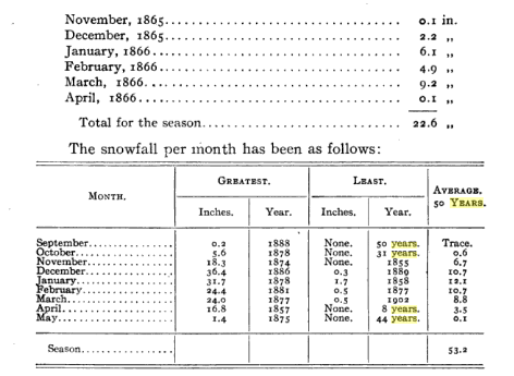
Anyways, I wouldn't take the snowfall numbers as gospel, since they were likely based on a single daily measurement and without the use of a snowboard. But several of these values would place favorably among the official records since 1893. Most notably, the 101.8" in 1880-81 would still rank as second snowiest of all time. The 22.6" observed in 1865-1866 would rank as 3rd least, just ahead of last winter and 1894-95 (22.7"). Also, the 0.2" observed on September 30, 1888 would be the earliest measurable snowfall on record in Cleveland, and the only time measurable snowfall has ever occurred in the month of September. The official record is the 0.3" observed on October 2, 2003. The 1.4" in May 1875 would be second most for that month. The 36.4" in December 1886 would be a record value. Several other of those months rank in the top 2-5 on both most and least snowfall. His average of 53.2" is probably underdone for the reasons I noted. But the current 30-year normal is around 63 inches. However, the moving 30-year average is down to about 54", the moving 10-year average is down to about 40" and the 5-year average (constituting the whole of the 2020s from 2019-2020 to 2023-2024) is down to around 33". Obviously, these values can come up a bit depending on how the remainder of the winter plays out, but not much. Even an unlikely two feet of additional snow from now through April would move the 30-year up by a fraction of an inch, the 10-year by 2.4" and the 5-year by 4.8".
-
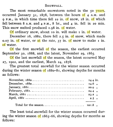
Oh, I forgot about this storm. I have read of it before. Likely, the biggest snowstorm observed in Cleveland, but official snow records don't begin until 1893. There was a volunteer who observed weather from 1855 - 1905, including snowfall. He reported 22.0" of snow, on 1.98" of liquid precipitation. 18" were said to have fallen in 8 hours, including a fall of 4" in one 20-minute period. This exceeds the 21.4" which fell during the "White Hurricane" of November 1913. Source: Journal of the Association of Engineering, July-Dec 1905. 50 years of weather at Cleveland.


