vortex95
-
Posts
1,493 -
Joined
Content Type
Profiles
Blogs
Forums
American Weather
Media Demo
Store
Gallery
Everything posted by vortex95
-
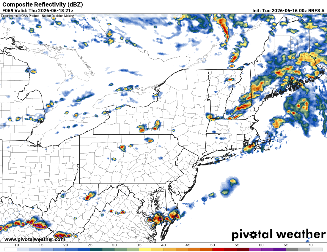
Working overnights so hence my delayed response. I say to CoastalWx and WxWiz, SPC added a 2% tor risk in New England in the DY2 1730z update!!!! (adding the exclamation points to be like Indeedsnow - LOL). "As I had been saying for tor risk..." 18z HRRR VT 22z Thu. 3 discrete supercells. PWM, PSM, and one just N of Woburn MA (where I am from). Scott needs a plan to chase!
-
Yes, but when it comes to sig tor events no matter where you are, the very small details are everything. One parameter off, or not sufficient, can make a big difference. For instance, dew points are few degrees lower in in BL than fcst. That raises the LFC, decreases 0-3 km CAPE, and makes supercells more outflow dominant, which curtails the high-end tornado potential or any tornadoes at all. There is very little difference between a sig tor event and a weak tor event if you look at the large picture. It can look perfect synoptically, but it comes down to the mesoscale in the end.
-
But that's how you get an EML!
-
-
But the CAPE is too low! "Only" 1291! Lapse rates not high by Midwest standards. So it works there but not here?
-
Good, we need the R+.
-
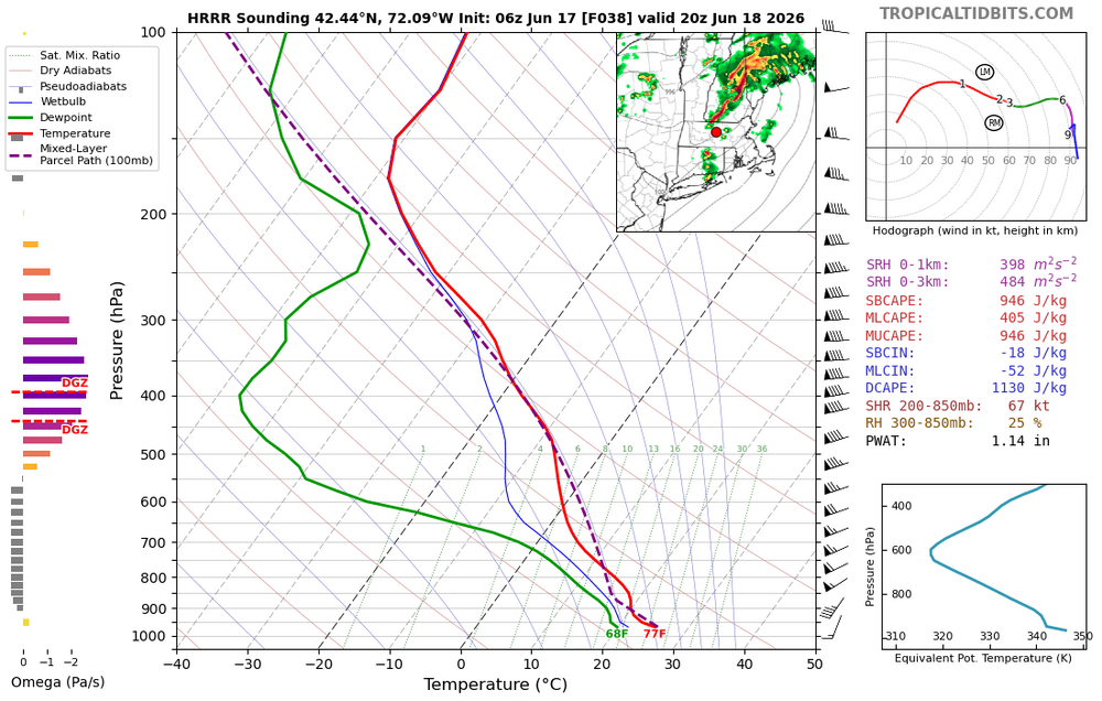
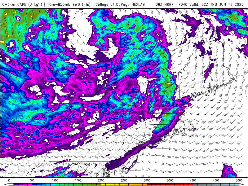
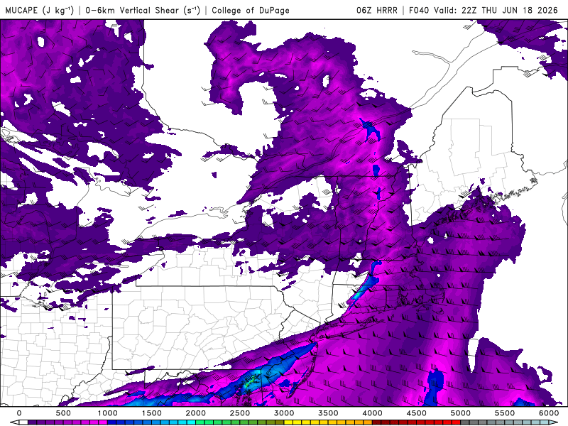
06z HRRR fcst sounding valid 20z Thu for central MA attached. Rhetorical question: Is that not a great hodograph for the NEUS? Nice long curve? CAPE is almost 1000. Yes it could be higher, but you can't just shake a stick at this sounding. Look at the shear values. Also, look at the 0-3km CAPE valid 22z. As high as 205. Anything above 75 is considered good for low-level vortex stretching and tors. Yes, SPC does not even has a 2% tor risk anywhere for E Coast, but that does not mean any can't occur. Also, HRRR fcst 22z, MU CAPE as high as 2100 over "WxWiz land." Hmmm. 1500-2000 CAPE w/ very high shear can and has "got it done" historically in the past for CONUS sig spinner days. Timing is ideal. Not trying to hedge or hype here, just calling it as I see it. The svr wx parameters look quite good to me. Coverage of svr I bet will be limited, but any individual storm could be nasty! "But we need an EML!!!!" Ugh, not every sig tor in New England has had a solid EML present!
-
EML for sig tor outbreak, yes, but it depends what we expect. SPC isn't going big, and I agree w/ how they are approaching it. However, I think the uncertainty is higher than usual due to the setup. When you have high-end anomalies, such as the wind fields here, that can lead to more surprises. I said earlier, I don't have a good analog for this particular setup, so that makes me nervous as to the surprise factor.
-
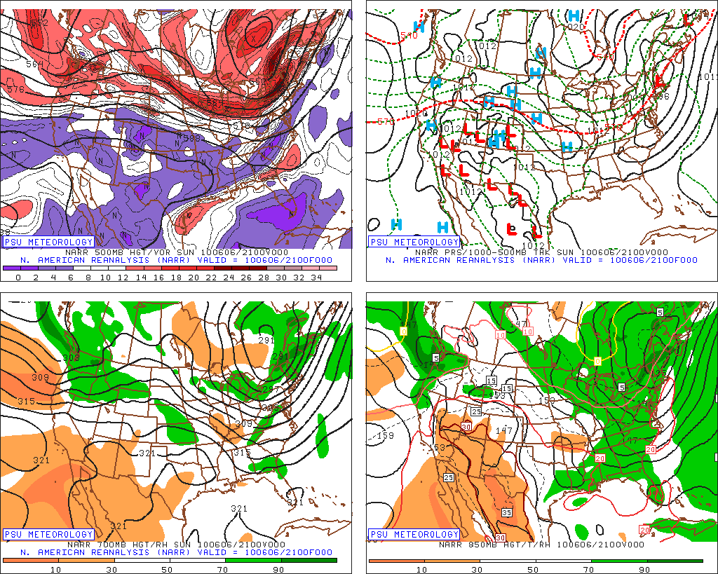
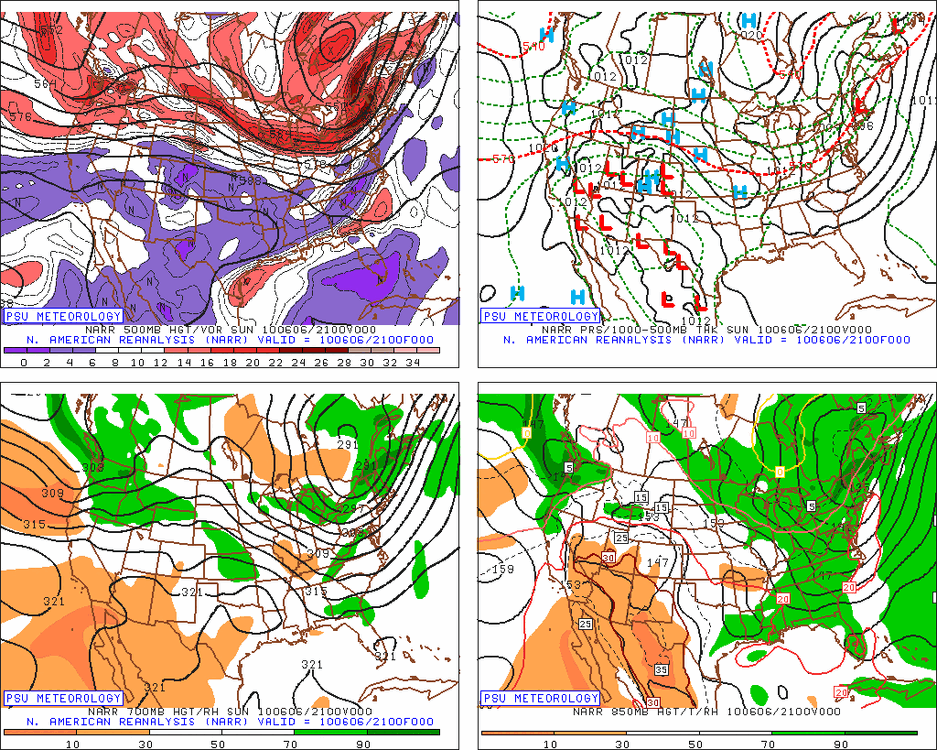
Took a look at it (attached). Not quite the same. Sfc low passed right over SNE rather than over srn Quebec. Also, sfc low Thu deeper than 2010 by 8-10 mb. Too much cloudiness in 2010? Even if this was very similar to 2010, minor differences can be a huge as to sensible wx when it comes to convective potential and the type of svr wx they produce, let alone how intense any given svr wx type may be. Also, I think we may be unimpressed by the SPC DY2 MRGL. Just b/c MRGL says zero about how intense any storm may be and the svr wx it produces. Maybe instead of three well-defined tornadic supercells that occurred on 7/10/89, they may be only one! But for ppl like WxWiz and CoastalWx who are always looking for the absolute max? One honkin' supercell is not enough!
-
I don't recall that day. Big bust?
-
Concerning low CAPE and high shear, look at what happened on 4/1/2023 in DE. WxWiz in disbelief and CoastalWx proby "MEH!" LOL. https://x.com/riotrogerriot/status/1642347623733444609 This is a full-blown tornadic supercell, but it doesn't look like one b/c the CAPE was low and shear very high. The CB is tilted over almost 90 deg! 500-1000 CAPE this day, but want to know what the 0-6 km shear was? 100 kt! This storm produced a long-tracked EF3. Isolated storm all by itself in the Delmarva. https://www.youtube.com/watch?v=4esg-DNoO5s https://www.youtube.com/watch?v=FyVPX7-ZHhw Other cells this day in DC area (not svr - I witnessed personally), they were just like this, so ridiculously titled over, they did not look like CBs, just a TCU cloud line. The rain/hail from these storms was *way* downwind (5+ mi) from the rear updraft base (it was hard to tell these bases existed b/c of the extreme tilt!). One my co-workers who lives near BWI reported he just started getting 1/2" hail and no rain falling, or any idea there was a storm near b/c of the odd storm orientation and no LTG/T. Something you'd more typically see in the Plains or Desert SW. Quite atypical for the East Coast, but it shows it can happen. And what do we have coming up for Thu? Quite atypical. "Hope floats" WxWiz!
-
Yes, this is a significant concern. Too much shear and not enough instability. You can get "cannonball CU" -- the building CU gets sliced by shear and you get part of the CU horizontally shooting downwind abruptly w/ a small cloud trail back to the other part of the CU! However, this go/no go for any CB here "winning" or "losing" is a fine line. If any CB can get established, the mesocyclone should be intense, and then CAPE does not matter nearly as much. It's why you can have as little as 100-200 CAPE and get sig tors. Most often this is in a TC situation, but it can happen in an ET low situation. CB updrafts are maintained extremely well despite low CAPE due to dynamic pressure perturbations induced by the mesocyclones. It also is why when an intense supercell moves into a stable (no CAPE) air mass, it can still produce tors for a little while longer b/c the intense mesocyclone present just doesn't go "poof!" The ante Thursday here is high here either way. It will definitely be a wicked nowcast situation watching storm development and evolving
-
I would caution this does not always work well. June 2, 1990 has a big tor outbreak in the Great Lakes/Midwest/OH Valley w/ IN getting absolutely crushed w/ 37 tor in the state (more than the 1974 Superoutbreak). 66 tor in this event w/ 7 F4s, and forecasts were big for NY/PA and New England for June 3, and a complete bust. https://en.wikipedia.org/wiki/June_1990_Lower_Ohio_Valley_tornado_outbreak
-
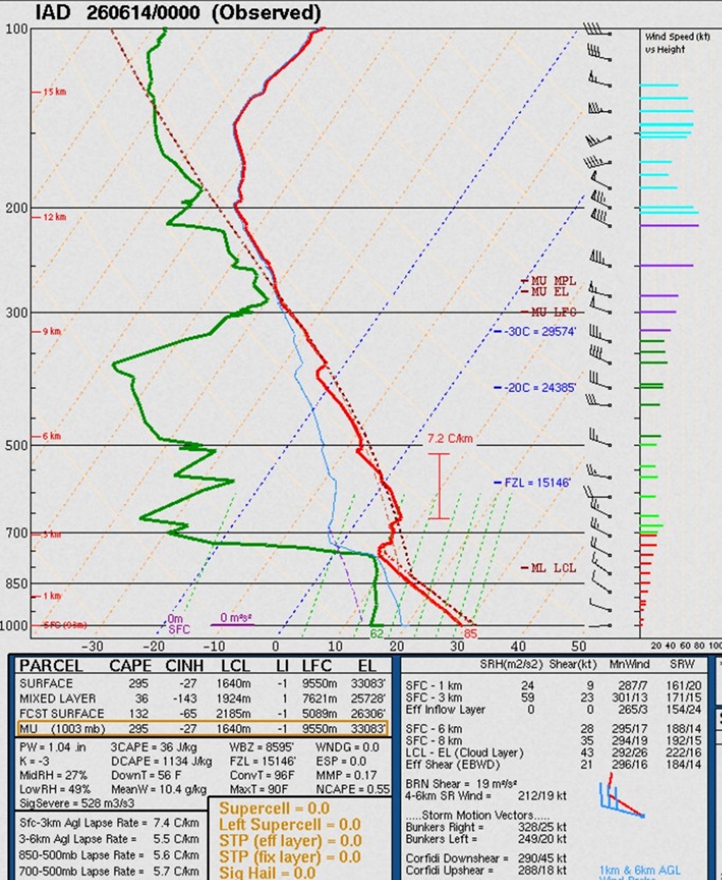
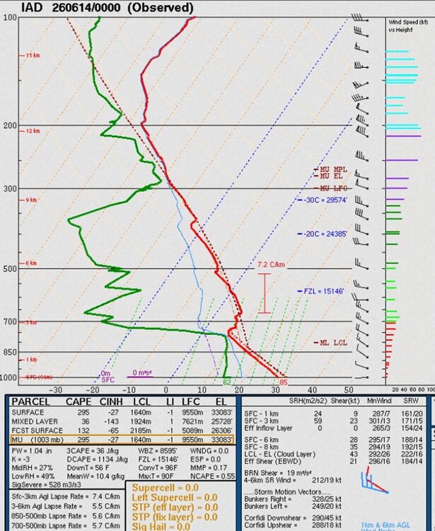
Timing is ideal and HRRR/RRFS show decent cells/lines! CBs in that kind of shear are likely going to do "something." I put it this way, "to have such a deep sfc low move over srn Quebec w/ those kinds of warm sector wind fields in June?, prove it to me something big will not happen!" We do not have set ups like this very often, so the full range of what can happen we really don't know. And this set up odd in itself b/c through the roof shear and low CAPE, but it not during the cool season! One thing about EMLs. 700-500 *only* can be misleading. Take a look at the IAD sounding 00z 6/14 I attached. 700-500 is crappy at 5.7 C/km, but compress that layer just a bit, and the max is 7.2 C/km...EML! I needed to inform CoastalWx about this, and he learned something new today!
-
That's the issue w/ AI models. They can't handle outlier events or set ups well, so they underdo things. Also, AI overdoing it is possible as you noted above. Not a one-sided problem I bet (non-linear factors). I keep hearing, "AI will get better." Well, isn't that the case for all types of modelling w/ time? And the notion that AI is improving so fast acting like it will solve all problems? All the AI advancement in the world is meaningless if you don't have many outlier events/analogs for it to pull from! And since outlier events are rare, progress in AI forecasts should be very slow. I would argue physics-based models will advance faster as in situ/remote observations get better globally for improved model initialization, along w/ better direct simulation of the atmosphere.
- 1,481 replies
-
- 5
-

-

-
- severe
- thunderstorms
- (and 7 more)
-
In any given situation, the worst-case scenario is the least likely to happen in the mean. The notion, "better safe than sorry" is a weasel line to give an excuse to always go w/ the worst-case scenario. Also, "we are saving lives!" Forecasts and awareness has become so good in recent decades, one can't hide behind that as an excuse anymore. Lives are lost now more IMHO b/c people have become numb and apathetic to the relentless hype. They have no idea what to believe, so many just tune it all out. That ends up costing lives when a truly exceptional event (worst-case) occurs, and it's made even worse b/c the exceptional events are greatest risk to lives. I admit though this is an extremely complex social issue, among other things, and no easy way to figure out what works best. One thing I will stand by solid though. "more [warnings/alerts} is not always better!"
-
Snowfall measuring practices were not completely standardized until the mid 1990s, even for long-term climate sites, and NYC is not immune to this issue. I think I have said this before, but generally, snowfall was underestimated prior to the NWS MAR in the 1990s. Some sites would only measure new snow *depth* once the storm was done, and call that the total. Other would melt a column of SOG, and then multiple by 10 for the snow total (blasphemy for the uber weenies!). Of all primary wx measurements we do, snowfall is by far the most inaccurate and variable in our record. Even today, there are fundamental challenges that make it hard at times to get an actual accurate amount.
-
That 34" in NJ. That's only, what, 1" from the record for the state set in the Bliz of 96? Blasphemy the 1947 event is called "Boxing Day Blizzard," at least for Scott. All he ever talks about is the 2010 blizzard for Boxing Day! LOL.
-
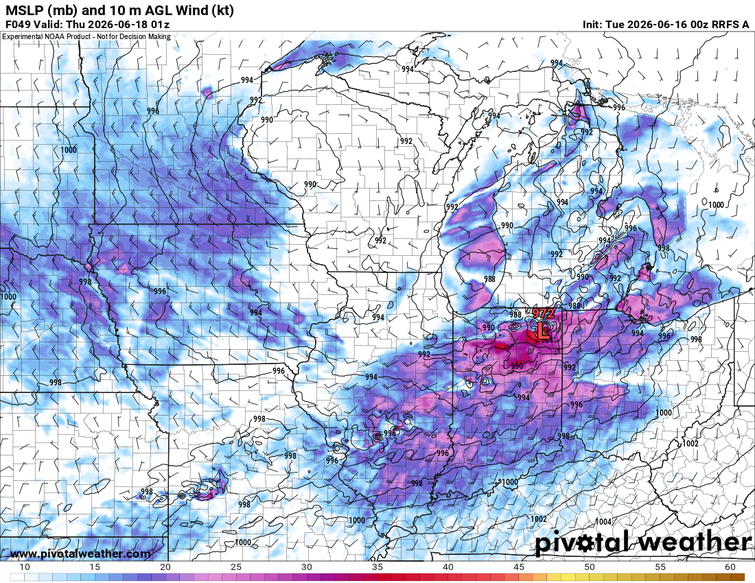
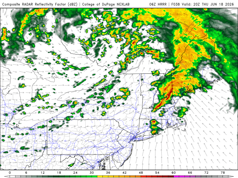
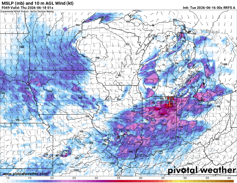
Also, the RRFS apparently can "see" intense mesocyclones! Look at the 972 mb "low" in nrn IN 01z Thu!
-
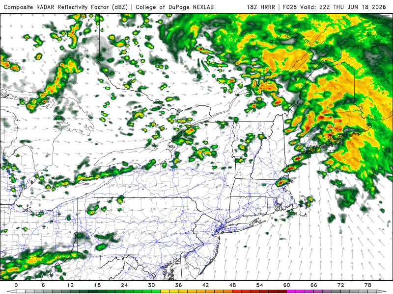
For Thu... I am impressed w/ the very strong WAA early on Thu in the NEUS. Atypical for summer. That looks to produce some sig tstms in itself. Thu afternoon is tricky b/c CAPE is lacking, but the shear is through the roof, as high as 85 kt 0-6 km and 45 kt 0-1 km. I can't think of any event in the last several decades w/ warm sector shear so high here this time of year when a strong sfc low passes just to our N. The 00z RRFS show a number of discrete storms Thu aftn w/ CAPE as high as 1150 in spots. I know the RRFS can get carried away and I don't have a good feel for it yet, but overall given the existing anomalies for the wind fields, I am quite concerned. I don't like that the sfc low is lifting/weakening as it moves across srn Quebec, but that may not matter in the end? Given such setups as so rare here, using the very limited past analogs we have for sig tor events in the NEUS, we don't really know the full spectrum or what can happen here b/c of that rarity in itself! I can honestly say I do not have a good forecast "feel" for this upcoming event in the NEUS b/c of the low CAPE, otherwise, it would be easy. It looks really nasty for the Midwest Wed -- off the charts for parameters. So how will that translate E? Not just in the NEUS, but in the Mid-Atlantic. Not every high-end svr event in the Great Lakes/OH Valley/Midwest this time of year ends up being big the next day to the E. I say "this time of year" b/c in the cool season, it is rare by default. In the NEUS, everyone often thinks of the June 8-9, 1953 outbreak sequence, but it doesn't always work like that. SPC DY3 outlook seems to focus on straight-line winds. That does seems more likely given the very fast storm motions and wind fields.

-
"Just give me 90, dews, and the beach." Incorrect, it should say, "just give me S+, S+, and S+!"
-
Crofton MD MB 6/11 (I think). Video never can capture the roar of the wind well, at least not the same as actually being there! https://www.facebook.com/reel/1658094618796584
-
*Any* wx anomaly or deviation now is news and hyped. Inane. As if everything should be exactly normal/avg all the time? Guess what, normal/avg doesn't exist as many think it does! And hyping how the planet works normally (that's what it has become now) and acting like something is wrong is pure drivel. You can make a living on-line now just finding anything going on across the globe to the smallest minutia and hype it as if it is significant. Basically taking the fact that "something is always going on" and making a big deal out of it no matter what. Have to have that CONTENT for clicks/likes, engagement bait, drive the algorithms, and monetize! It has become a sideshow within a sideshow and race to the bottom.
-
-
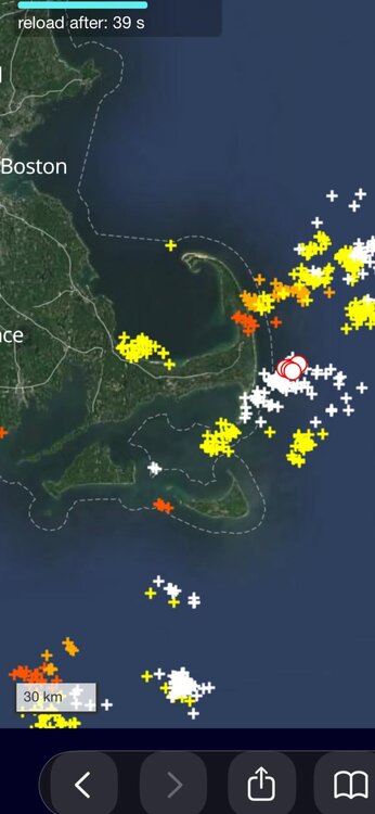
But Cape Cod!!!