vortex95
-
Posts
1,493 -
Joined
Content Type
Profiles
Blogs
Forums
American Weather
Media Demo
Store
Gallery
Everything posted by vortex95
-
That looks suspicious. Anytime you see trees sheared/snapped off mid-way like that, that suggests PSBL SPINNER!
-
Max I see so far is 2.76" Kingfield ME. Meso models showed the NNE R+ well. Mt. Mansfield 2.08"
-
That S+ event was truly exceptional! Even I was impressed! It takes a lot to impress me big for wx events these days. When you study wx history and records a lot, that tends to do that.
-
Well, CoastalWx had a spinner in Weymouth a few years ago, and he is still EEYORE! How many of us can claim we had a spinner in New England history in their hometown, given how many cities/towns there are? My claim to fame is an F2 in late Oct 1925 in Woburn - the strongest spinner for so late in the season in New England.
-
Yes it is! For comparison, the July 10, 1989 "WxWiz PT event" (most spinners on record in one day in New England (9) and largest NEUS outbreak for spinners adding in ern NY/LI and nrn NJ (17), the sfc low that tracked across srn Quebec and nrn ME deepened "only" from 1000 to 998 mb during the event. However, this event had an excellent EML, and no upstream convection the day before, so EML pure!
-
-
-
Now that's stupid. What, now cancel everything for a slight risk of svr? We can't be "held hostage" by the wx for the mere fact there is risk out there! I am reminded of the 2009-10 winter when DCA got slammed and CoastalWx was shutout. The hype was SO out of control, locations in the Northeast such as BUF, that were not going to see a single flake of snow, they cancelled things b/c of the crazy storm hype. I recall OCMs from YYZ at an AMS conference in 2012 stating the stupid hype from the U.S. stations bleed into Canada, and that was messing things up in Toronto! This is one reason why I slam the MSM so much, this constant hype and installing fear is counterproductive for society. There are real social and economic costs/losses b/c of being put in a state of alert all the time. Every inclement wx is treated as "so dangerous." The ordinary gets turned into the extraordinary needlessly. How did society ever survive and progress back in the day before all this nonsense? Society is being turned into a bunch of softies, unable to handle physically or psychologically any risk/hazard.
-
Yes, we can see the shortcomings in AI in simple daily tasks , so how can we possibly expect it to handle complex problems/issues? There will be a societal/business self-realization soon enough once the hype and novelty of AI wears off. We will eventually figure out what works well and what does not for AI, and I think that will benefit society overall.
- 1,482 replies
-
- 1
-

-
- severe
- thunderstorms
- (and 7 more)
-
Nice drink?

-
I'm just tired of the Debbie Downer attitude from CoastalWx. Might as well call him EEYORE!
-
I know this heat index sound impressive, but did you know that in the Middle East, it can go *far* higher? Every July-August at Qeshm Island, Iran (METAR code OIKQ), dew points routinely get into the 90s, and on some mornings, the heat index exceeds 150. A few years ago in August, they had 100/97 for a heat index of nearly 180! This is in the Persian Gulf. These very high readings occur in the morning w/ fog is present and light winds off the water. These readings are accurate looking at the daily observations, where the dew points are very high overnight and in the morning, only to mix out quickly by the afternoon and drop quite a bit. Population of the island is 149,000. Takeaways here are that it goes to show humans can endure far higher heat indices and do just fine, and what happens in the Middle East makes heat indices in the U.S. look like a walk in the park, relatively speaking. Context and perspective are important when discussing wx extremes and impacts.
-
You are not paying attention. Do you not see the isolated supercell to your W on the HRRR fcst I sent? Very disappointing you are downplaying this event.
-
I don't know...
-
"If it's not in Weymouth, it doesn't matter!" What kind of attitude is that?
-
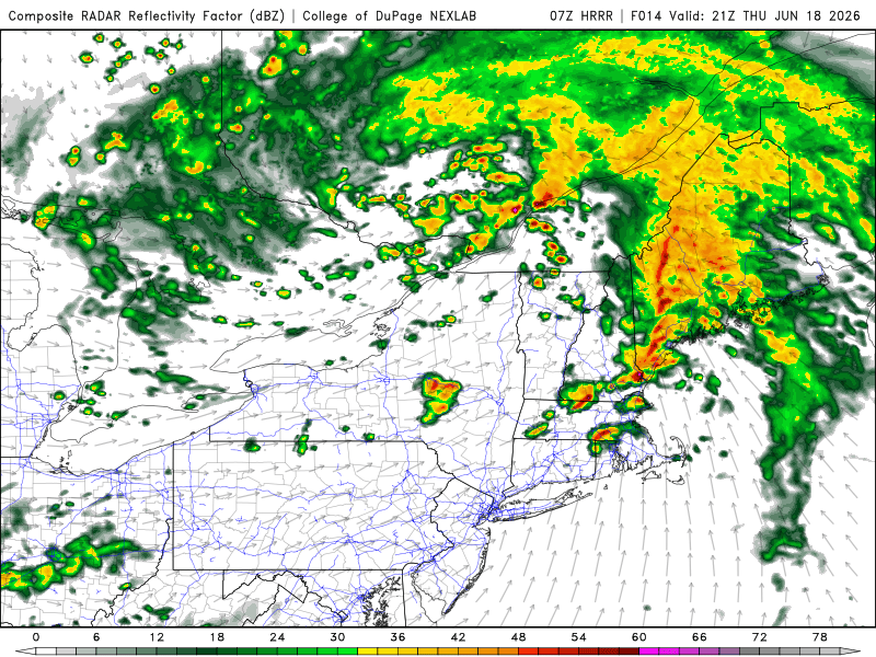
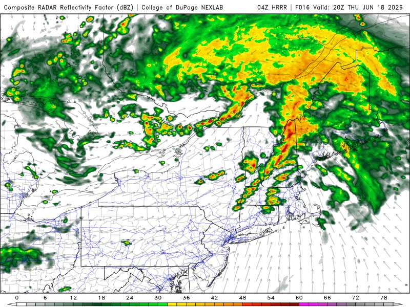
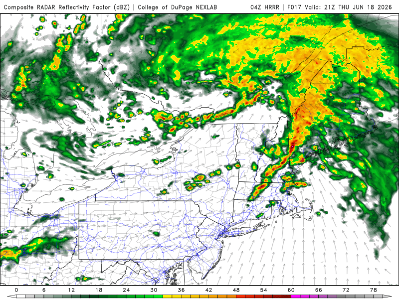
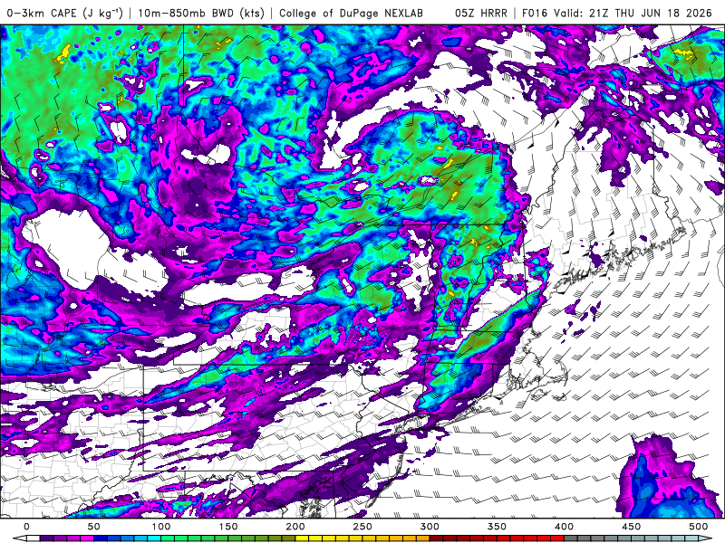
04z HRRR suggesting "cells ahead of line." So 1-2 punch for some areas. Also, nice sliver of high 0-3km CAPE SNE and a second area for NNE.
-
Hmmm, CoastalWx and WxWiz be like "???????." 5% tor risk? How can this be? No EML!
-
Ineedsnow will be "X-static" if we get 5% tor, but WxWiz will not b/c he can't chase!
-
We have a lot of climo for TC tracks globally, so AI has a lot to draw from, so it should do well here. Intensity, not so much. There are still so many things we can't model well for the stronger TCs. The inner cores of the intense ones are basically mesoscale features. RI occurs often in such a short time frame and it is hard for physics-based models to handle. For decades, we have seen a steady improvement in TC tracks, but very little for intensity until the 2010s, when significant improvement occurred. So again, AI should do well for TC tracks. And TC tracks often are latitude/longitude dependent, so this variable is a solid base indicator for AI to use.
- 1,482 replies
-
- 1
-
-
- severe
- thunderstorms
- (and 7 more)
-
This happens *every* time new technology becomes available. It is sold as the best thing since sliced bread w/ lofty claims. I recall in the 80s it was said "in 10-15 year advancement in computer modelling will make human forecasting obsolete!' Right, how did that work out? In fairness, computer modelling advancement has removed a lot of manual work a human used to do, but this is a *good* thing actually. Why?, b/c the shear volume of wx data now is enormous and keeps increasing. We need faster computers and AI to help sort and manage it all (do the grunt heavy lifting) so the human forecast can provide the insight/wisdom/understanding -- which AI does not have -- to give concise and clear messages to all. That's one reason why IDSS is so big in the NWS. Forecasts have become very good, but the real challenge is *communicating* it all effectively in this information overload and social media world. So I would not worry about AI "taking over," so to speak, anytime soon.
- 1,482 replies
-
- 1
-

-
- severe
- thunderstorms
- (and 7 more)
-
You are missing the point. Teleconnections deal w/ broad scale patterns. That only works/is useful to a point. When it comes to actual sensible wx in a specific area, that's an entirely different ballgame. How many times do we have a -NAO, and no big East Coast snowstorm occurs, as one example? I pointed out the mesoscale details being everything for all to read here, and learn something from it. You look on social media, and far too often you see people hyping certain patterns, and stating this or that will happen in X or Y region w/o stating any caveats or how it's not so simple/linear as a 1-1 correlation. People on this forum, some are still learning and other are eager to learn more, and furthering the discussion is of value net-net. And in New England, many just think about the outbreak sequence June 8-9, 1953. That is a high-end, outlier exception, and that can skew the perception of things from a local bias POV.
-
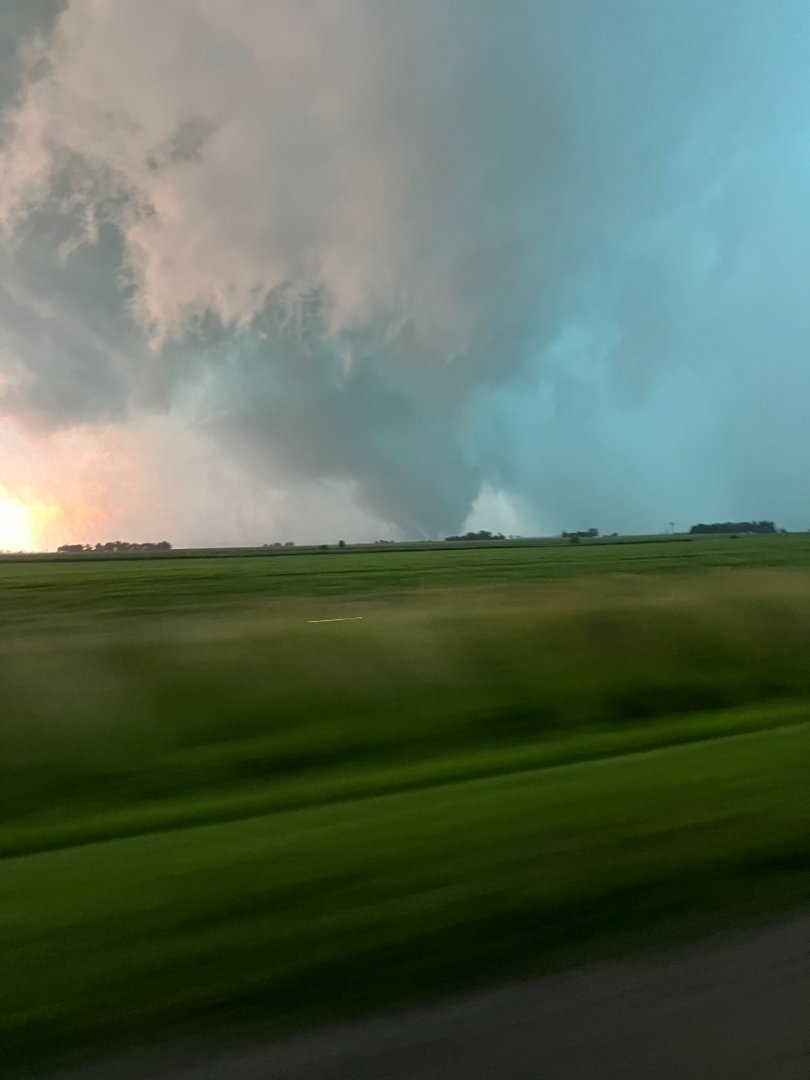
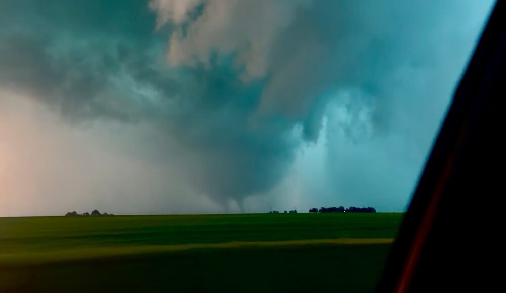
Charleston IL spinner PT.

-

-
Spinner paradise!
-
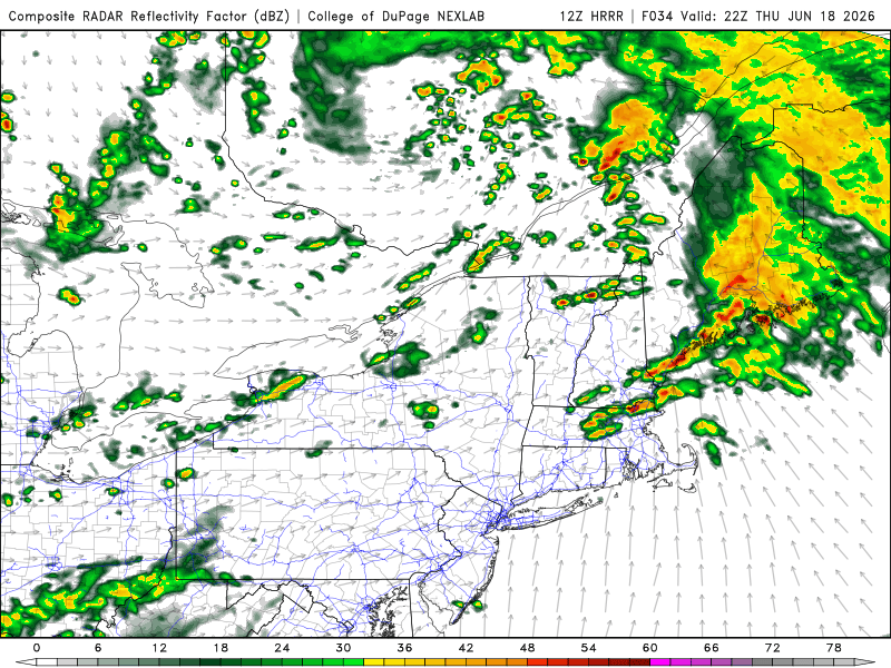
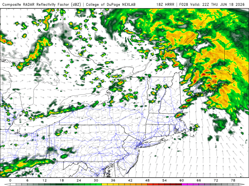
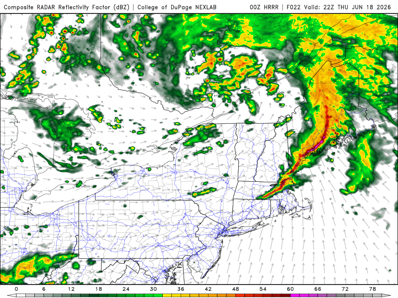
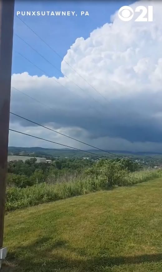
So here are the last 3 runs of the HRRR 12/18/00z all valid 6pm Thu. Which one will be right? It's impossible to tell. Small details on the mesoscale can make a big difference as to storm mode. Either way, the timing for this is ideal. 0-3 km CAPE from central NH to CT is high as 150 at 6pm. And that is big for spinner potential and 150 is more than enough. Perhaps this is what we will get Thu. Li'l spin-ups w/ nice crisp titled CB vistas! Punxsutawney PA spinner 6/14/26. https://www.facebook.com/reel/1355336163205600