binbisso
-
Posts
889 -
Joined
-
Last visited
Content Type
Profiles
Blogs
Forums
American Weather
Media Demo
Store
Gallery
Everything posted by binbisso
-
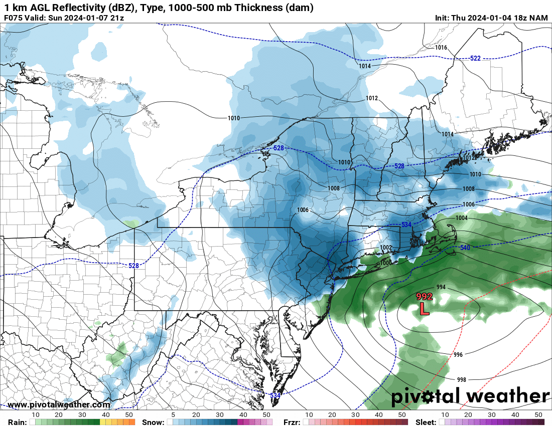
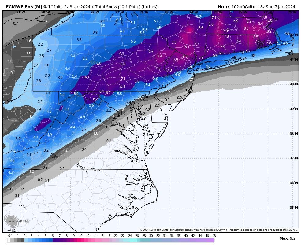
Interesting disco from Upton for you guys in coastal Connecticut. " Meanwhile, steady snow which may become heavy at times for portions of the interior is expected through the evening and overnight. As such, Winter Storm Watches remain in effect for interior portions of the Lower Hudson Valley, NE NJ, and Southern Connecticut. There remains a fair amount of uncertainty as to how far north the rain/snow line moves. A stronger system may bring heavier mesoscale banding and a more northerly component of the wind which may allow for enhanced snow totals for the immediate CT coastline and southern Westchester County, where a weaker system may allow for warmer air to infiltrate further inland and provide for more rain than snow. These details may not be known until the storm is underway."
-
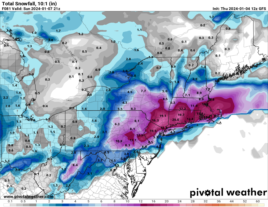
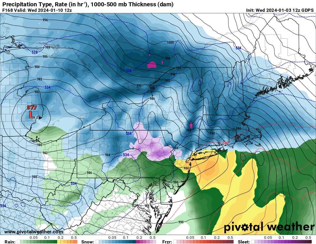
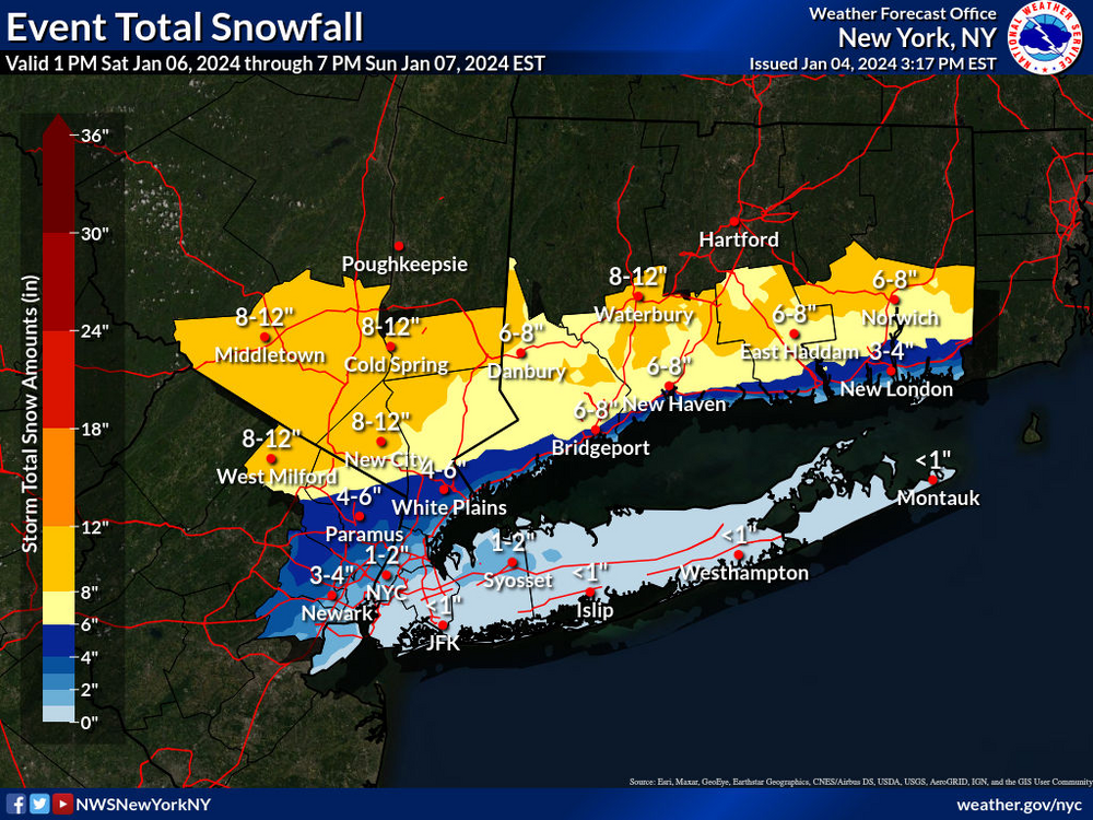
Two Mdt to high impact events NYC subforum; wknd Jan 6-7 Incl OBS, and mid week Jan 9-10 (incl OBS). Total water equiv by 00z/11 general 2", possibly 6" includes snow-ice mainly interior. RVR flood potential increases Jan 10 and beyond. Damaging wind.
binbisso replied to wdrag's topic in New York City Metro
Interestig disco from nws. At least for my area in lower Westchester. "Meanwhile, steady snow which may become heavy at times for portions of the interior is expected through the evening and overnight. As such, Winter Storm Watches remain in effect for interior portions of the Lower Hudson Valley, NE NJ, and Southern Connecticut. There remains a fair amount of uncertainty as to how far north the rain/snow line moves. A stronger system may bring heavier mesoscale banding and a more northerly component of the wind which may allow for enhanced snow totals for the immediate CT coastline and southern Westchester County, where a weaker system may allow for warmer air to infiltrate further inland and provide for more rain than snow. These details may not be known until the storm is underway."- 3,610 replies
-
- 3
-

-
- snow
- heavy rain
- (and 5 more)
-
Two Mdt to high impact events NYC subforum; wknd Jan 6-7 Incl OBS, and mid week Jan 9-10 (incl OBS). Total water equiv by 00z/11 general 2", possibly 6" includes snow-ice mainly interior. RVR flood potential increases Jan 10 and beyond. Damaging wind.
binbisso replied to wdrag's topic in New York City Metro
- 3,610 replies
-
- 2
-
-

-
- snow
- heavy rain
- (and 5 more)
-
Two Mdt to high impact events NYC subforum; wknd Jan 6-7 Incl OBS, and mid week Jan 9-10 (incl OBS). Total water equiv by 00z/11 general 2", possibly 6" includes snow-ice mainly interior. RVR flood potential increases Jan 10 and beyond. Damaging wind.
binbisso replied to wdrag's topic in New York City Metro
What a forecasting nightmare.- 3,610 replies
-
- 1
-

-
- snow
- heavy rain
- (and 5 more)
-
Two Mdt to high impact events NYC subforum; wknd Jan 6-7 Incl OBS, and mid week Jan 9-10 (incl OBS). Total water equiv by 00z/11 general 2", possibly 6" includes snow-ice mainly interior. RVR flood potential increases Jan 10 and beyond. Damaging wind.
binbisso replied to wdrag's topic in New York City Metro
What a turn of events this afternoon.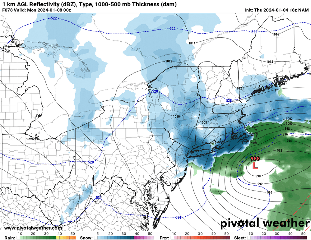
- 3,610 replies
-
- 1
-
-
- snow
- heavy rain
- (and 5 more)
-
Two Mdt to high impact events NYC subforum; wknd Jan 6-7 Incl OBS, and mid week Jan 9-10 (incl OBS). Total water equiv by 00z/11 general 2", possibly 6" includes snow-ice mainly interior. RVR flood potential increases Jan 10 and beyond. Damaging wind.
binbisso replied to wdrag's topic in New York City Metro
The nam blows Up the second short wave.
- 3,610 replies
-
- 2
-
-
-
- snow
- heavy rain
- (and 5 more)
-
Two Mdt to high impact events NYC subforum; wknd Jan 6-7 Incl OBS, and mid week Jan 9-10 (incl OBS). Total water equiv by 00z/11 general 2", possibly 6" includes snow-ice mainly interior. RVR flood potential increases Jan 10 and beyond. Damaging wind.
binbisso replied to wdrag's topic in New York City Metro
The other thing to watch as some in the New England forum have said Is to watch that trailing short wave. If it can catch the lead short wave below us as the GFS shows It could be fun here Sunday.- 3,610 replies
-
- 1
-
-
- snow
- heavy rain
- (and 5 more)
-
Two Mdt to high impact events NYC subforum; wknd Jan 6-7 Incl OBS, and mid week Jan 9-10 (incl OBS). Total water equiv by 00z/11 general 2", possibly 6" includes snow-ice mainly interior. RVR flood potential increases Jan 10 and beyond. Damaging wind.
binbisso replied to wdrag's topic in New York City Metro

- 3,610 replies
-
- 5
-
-

-
-
- snow
- heavy rain
- (and 5 more)
-
Two Mdt to high impact events NYC subforum; wknd Jan 6-7 Incl OBS, and mid week Jan 9-10 (incl OBS). Total water equiv by 00z/11 general 2", possibly 6" includes snow-ice mainly interior. RVR flood potential increases Jan 10 and beyond. Damaging wind.
binbisso replied to wdrag's topic in New York City Metro
Gfs gone bonkers- 3,610 replies
-
- 1
-
-
- snow
- heavy rain
- (and 5 more)
-
Two Mdt to high impact events NYC subforum; wknd Jan 6-7 Incl OBS, and mid week Jan 9-10 (incl OBS). Total water equiv by 00z/11 general 2", possibly 6" includes snow-ice mainly interior. RVR flood potential increases Jan 10 and beyond. Damaging wind.
binbisso replied to wdrag's topic in New York City Metro
The trend so far on today's 12Z guidance Is the lead short wave is further East. We need that as Far East as possible before it turns the corner up the coast. That should allow for a more northeasterly component to the wind and help lock in whatever cold air we have.- 3,610 replies
-
- 1
-
-
- snow
- heavy rain
- (and 5 more)
-
Two Mdt to high impact events NYC subforum; wknd Jan 6-7 Incl OBS, and mid week Jan 9-10 (incl OBS). Total water equiv by 00z/11 general 2", possibly 6" includes snow-ice mainly interior. RVR flood potential increases Jan 10 and beyond. Damaging wind.
binbisso replied to wdrag's topic in New York City Metro
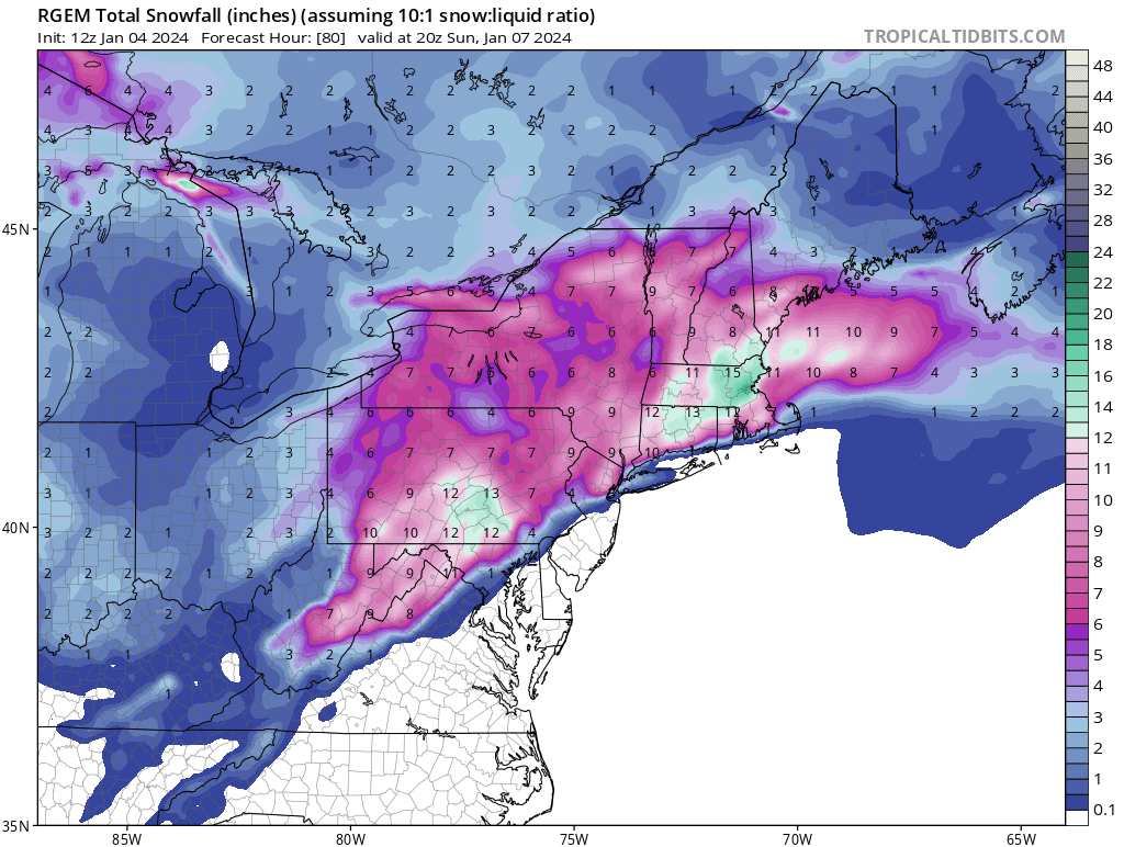
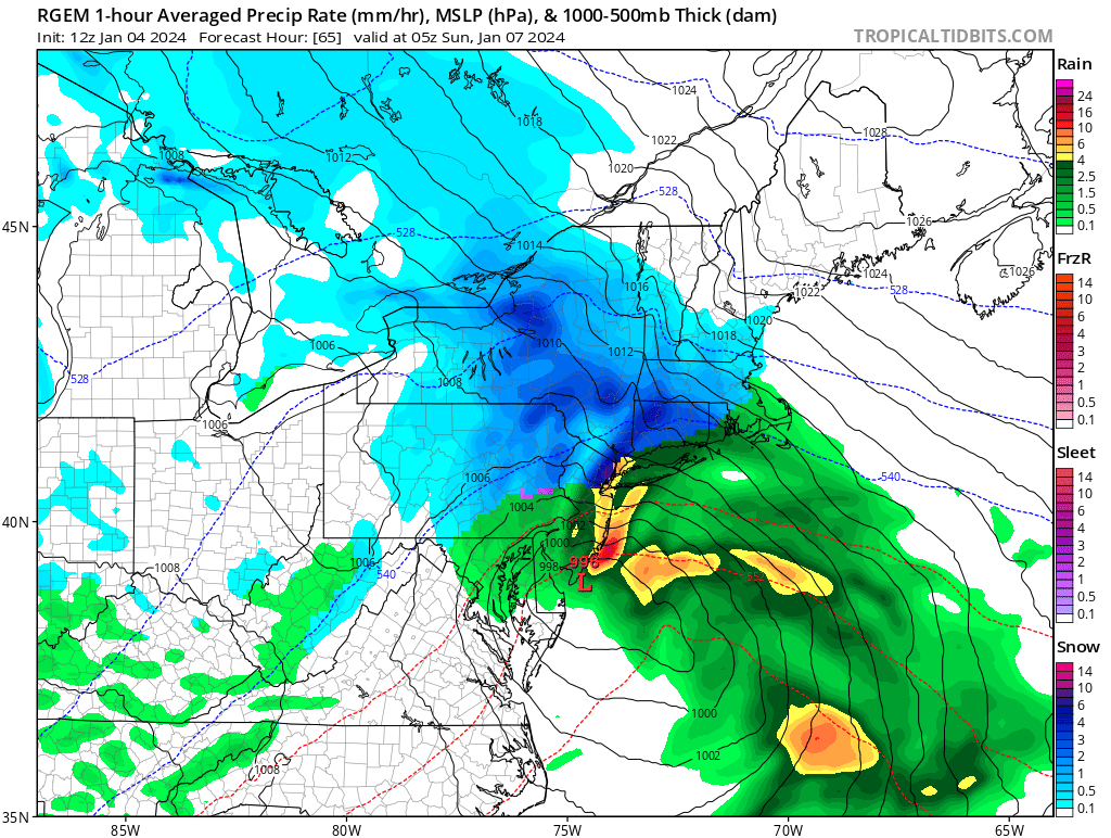
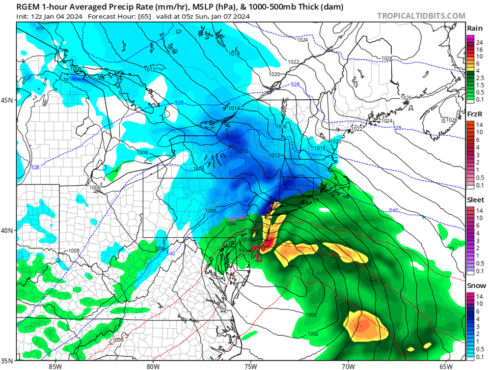
The rgem has very heavy precip right over nyc and adjacent nj early on. Model shows snow. I believe we will need heavy rates and wet bulb to snow there. Clown map just for fun.
- 3,610 replies
-
- 1
-
-
- snow
- heavy rain
- (and 5 more)
-
Two Mdt to high impact events NYC subforum; wknd Jan 6-7 Incl OBS, and mid week Jan 9-10 (incl OBS). Total water equiv by 00z/11 general 2", possibly 6" includes snow-ice mainly interior. RVR flood potential increases Jan 10 and beyond. Damaging wind.
binbisso replied to wdrag's topic in New York City Metro
No. That's the mean. In the new England thread they have the different percentiles -
Two Mdt to high impact events NYC subforum; wknd Jan 6-7 Incl OBS, and mid week Jan 9-10 (incl OBS). Total water equiv by 00z/11 general 2", possibly 6" includes snow-ice mainly interior. RVR flood potential increases Jan 10 and beyond. Damaging wind.
binbisso replied to wdrag's topic in New York City Metro
Taken from mid Atlantic thread. All is not lost. Hopefully we can get a few inches out of this.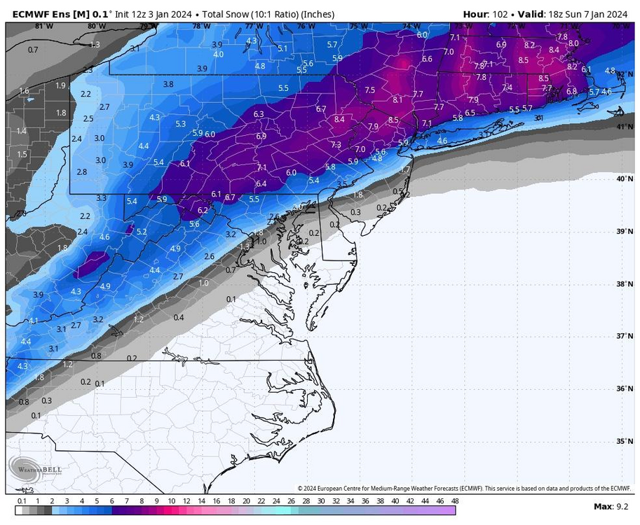
- 3,610 replies
-
- 2
-
-
- snow
- heavy rain
- (and 5 more)
-
Confluence as much better through hour 72.
-
Man you have to love el-nino. What an active pattern. We should have plenty of chances the next two weeks. Maybe we fail but fun to track
-
Yup. Gfs has another one on the 15th.
-
Two Mdt to high impact events NYC subforum; wknd Jan 6-7 Incl OBS, and mid week Jan 9-10 (incl OBS). Total water equiv by 00z/11 general 2", possibly 6" includes snow-ice mainly interior. RVR flood potential increases Jan 10 and beyond. Damaging wind.
binbisso replied to wdrag's topic in New York City Metro
The two positives are The snow will fall at night and temperatures Friday night will be in the low 20s away from the immediate shore and heat islands.- 3,610 replies
-
- 1
-
-
- snow
- heavy rain
- (and 5 more)
-
For the tenth we need that trailing s/w on the 7th to amplify as it moves towards the Canadian maritime. Set up a nice 50/50 low
-
Big hp in Eastern Canada. Those are hard to move in January
-
Wow at the cmc for the 10th. Gfs also.

-
It looks like the storm on the 11th setting up nicely on this Euro run.
-
A 100% agree. Just get us to near normal temperature wise on January 1st and I'll roll the dice with that 500 MB pattern the ensembles are showing
-
Yeah I don't get it. By January 1st were starting to get to peak climo. Who wants 15° for a high temperature and 0 for a low? We don't need that. We need a favorable 500 mb Pattern with storm sliding on south of us, which is exactly What guidance is showing. Otherwise it's congrats Richmond.
-
A plus 4 temperature departure at 7 AM January 1st is plenty cold to snow In much of the sub forum. At that time my normal low is 25°. As long as the system is beneath us, which is what guidance is showing,
-
I like seeing these strong hp to our north and the trough underneath us. Also n/s short waves sliding down the ridge in Central Canada will give us chances until that ridge moves west. Should be cold enough for frozen if they slide under us. So while this December will be solidly above normal I think we should have some opportunities for snow