

Kmlwx
-
Posts
13,549 -
Joined
-
Last visited
Content Type
Profiles
Blogs
Forums
American Weather
Media Demo
Store
Gallery
Everything posted by Kmlwx
-

Late January and February Medium/Long Range Discussion
Kmlwx replied to WinterWxLuvr's topic in Mid Atlantic
Normally I'd say maybe it's the increased resolution - but the HRRR being in line with the other guidance tells me maybe the 3km NAM is smoking something. -
Late January and February Medium/Long Range Discussion
Kmlwx replied to WinterWxLuvr's topic in Mid Atlantic
You should switch to doing pbp of the 250mb level without telling anyone. Would be some confused weenies in here. -
@Maestrobjwa - Definitely want to echo what others have said. You do seem to honestly want to work on it - and that's great!. But if weather makes you legitimately want to throw things in anger it might be crossing from being a hobby to being something unhealthy. I don't mean to sound funny - but what @Ji has sort of turned into his "thing" on the board - you genuinely seem to be experiencing for real on your side. Of course everyone has different interests/hobbies etc - but I've picked up a bunch of new stuff to occupy time between various weather events. It makes things way more tolerable. Anything from fossil hunting at Calvert Cliffs to getting a board game group together. Just things to bridge the gap. Get yourself into astronomy events or something - that way things like the Perseids meteor showers or cool eclipse events get you excited as well. Weather as a hobby should be fun - sure there's some disappointment built in - but it's like seeing your favorite team lose in playoffs. It stings and you keep moving to the next hobby or season. I hope snow/weather can go from being a stressful hobby for you to being one that you enjoy more wholly.
-
January 28-29 2022 Miller abcdefu Storm Obs/Discussion
Kmlwx replied to mappy's topic in Mid Atlantic
It almost sounds like some rain mixed in here in Colesville. BUT it's 31.8. Thinking it may just be water dripping off of trees and branches. Definitely not as pretty as the snow earlier in this lighter stuff. -
January 28-29 2022 Miller abcdefu Storm Obs/Discussion
Kmlwx replied to mappy's topic in Mid Atlantic
Radar shows that deathband cycling up again. Down to 33.5 here now. Could start to see accumulation soon! -
January 28-29 2022 Miller abcdefu Storm Obs/Discussion
Kmlwx replied to mappy's topic in Mid Atlantic
Deathbanded.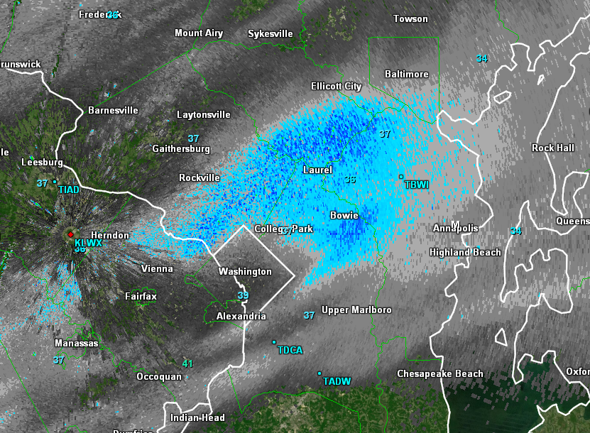
-
January 28-29 2022 Miller abcdefu Storm Obs/Discussion
Kmlwx replied to mappy's topic in Mid Atlantic
Steady light snow here now in Colesville, MD. Temp right around 35. -
January 28-29 2022 Miller abcdefu Storm Obs/Discussion
Kmlwx replied to mappy's topic in Mid Atlantic
Should help destabilize for the thunderstorms later. 36.7 here now after getting up to around 39 a little while ago. -
January 28-29 2022 Miller abcdefu Storm Obs/Discussion
Kmlwx replied to mappy's topic in Mid Atlantic
It's over -
Late January and February Medium/Long Range Discussion
Kmlwx replied to WinterWxLuvr's topic in Mid Atlantic
Some of it is exactly what he said about it being "what I grew up with" - so a little of the "Texas Sharpshooter" phenomena. If I shoot at the side of a barn 10 times and circle the 3 closest shots to the center and call myself a Texas Sharpshooter - doesn't make it true. Biases of course exist.- 4,130 replies
-
- 1
-

-
- prime climo
- cold canada
- (and 1 more)
-
Late January and February Medium/Long Range Discussion
Kmlwx replied to WinterWxLuvr's topic in Mid Atlantic
I think we are mostly on the same page to be honest. I forget how old you are. Ultimately I'm hoping we'll score something during the upcoming pattern that won't be so much of a subforum divider. -
January 28-29 2022 Miller abcdefu Storm Obs/Discussion
Kmlwx replied to mappy's topic in Mid Atlantic
38ish degrees here now. -
Late January and February Medium/Long Range Discussion
Kmlwx replied to WinterWxLuvr's topic in Mid Atlantic
Absolutely agree. And I think you worded that much better than I did (no surprise there). There is zero doubt in my mind that there's a new "normal" and we'll have to get used to it. And we may not even be done adjusting the goalposts either. That said - I think @Maestrobjwa - (no offense intended) does tend to have pretty high expectations and substantial agony when things don't line up for snow here. I guess it was more of an attempt to walk him back from the panic room than anything else. No doubt we all love snow - not all of us can be in the new @Bob Chill mentality...but we will be depressed messes if we tie all of our happiness to big snow. Give me some more of the Jan 3 storm and I'd be happy. HECS are great - but we can't do them every time. There's definitely something to be said about the proliferation of snow maps making the bar go sky high and people expecting huge storms every time the models hint at something even at long leads.- 4,130 replies
-
- 3
-
-

-
- prime climo
- cold canada
- (and 1 more)
-
Late January and February Medium/Long Range Discussion
Kmlwx replied to WinterWxLuvr's topic in Mid Atlantic
I think you may have unrealistic hopes/expectations for DC winters. There have been BAD stretches through the records. 6 years isn't too bad. Sure it sucks - but DC/Balt is NOT a snow region. We go on heaters sometimes, but again, we are not a snow town for the vast majority of years. Even our seasonal snow climo is thrown off by years like 09-10 - so it's not a great judge of "you should expect this each year" If you have the means to chase upslope and stuff - that's the way to go. Otherwise you've gotta just enjoy the snow we do get, and track other types of weather while we wait. It's why I'm into severe weather in the spring/summer. Hell...I'll even track wind events. Feeling like "we're owed or we're due" for snow is as futile as waiting on the next major tropical system to come through the area. It's disheartening at times - but that's why you've gotta just distract yourself with other stuff. Take up hobbies that interest you other than weather and fill the time with them.- 4,130 replies
-
- 2
-
-
- prime climo
- cold canada
- (and 1 more)
-
January 28-29 2022 Miller abcdefu Storm Obs/Discussion
Kmlwx replied to mappy's topic in Mid Atlantic
Yeah - I just checked TBWI and it looked anemic. Seems like it must be virga/elevated. It does show up nicely on the TIAD radar. -
January 28-29 2022 Miller abcdefu Storm Obs/Discussion
Kmlwx replied to mappy's topic in Mid Atlantic
Any ground truth from the Severn or Pasadena areas? -
Late January and February Medium/Long Range Discussion
Kmlwx replied to WinterWxLuvr's topic in Mid Atlantic
This weekend is in the other thread. This is the longer range thread. -
I actually will sometimes during severe weather/storms run to my front window and yell HAIL - it always cracks me up. My memory is oddly niche sometimes.
-
Yep - good old AIM with my "KennyWeather" screen name. Cringe.
-
I remember a very enthusiastic YouTube video of you (I think it was you at least) during a decent, but all things considered, relatively garden variety storm - and you yelling "WE GOT HAIL. HAIL!"
-
Don't remind me of the olden days. My weather weenie side was not a time I am proud of
-
I get what both of you are saying. But I think what he's saying is that the models don't "remember" what they predicted X number of cycles ago. They take in the data ingested for the latest cycle and run math calculations to spit out what it thinks the atmosphere will do. The perception of "trends" is there - but it's in the initialization of the models and our analysis of it... So yes - initilization over several cycles could analyze that a piece of energy is stronger each time. But that's not the model trending in that sense - it's the starting data adjusting in real time.
-
Can't wait for how unreadable things will be when all the 0z guidance shifts way offshore
-
Some of the analysis over in the storm thread is lol-worthy.
-
Good advice! My scrolling finger is going to get a workout...I also hate muting people...because often times even the awful posters sometimes are nice to interact with in the off season. I don't have a single person muted. Snow is DEFINITELY a mood booster - but there's too many other more important things to let it burn bridges on a weather forum.
