

Kmlwx
-
Posts
13,549 -
Joined
-
Last visited
Content Type
Profiles
Blogs
Forums
American Weather
Media Demo
Store
Gallery
Everything posted by Kmlwx
-

2022 Mid-Atlantic Severe Wx Thread (General Discussion Etc)
Kmlwx replied to Kmlwx's topic in Mid Atlantic
Well northern folks at least. -
2022 Mid-Atlantic Severe Wx Thread (General Discussion Etc)
Kmlwx replied to Kmlwx's topic in Mid Atlantic
We got a watch! lol -
2022 Mid-Atlantic Severe Wx Thread (General Discussion Etc)
Kmlwx replied to Kmlwx's topic in Mid Atlantic
We always seem to manage 1-3 of these early season slights per year. I doubt any of us even hear thunder this PM - but we do winds pretty well. -
2022 Mid-Atlantic Severe Wx Thread (General Discussion Etc)
Kmlwx replied to Kmlwx's topic in Mid Atlantic
LWX indicates negligible instability. So we'll see how well the gusty showers can do. Ridiculously warm this morning for 3/7. Has "the feel" - at least the early season feel. -
This could have easily been in the banter thread or via a PM. It just serves to clutter the thread(s).
-
It's also much higher than all the rest of the guidance. Everything else is down in the 45-55mph range.
-
2022 Mid-Atlantic Severe Wx Thread (General Discussion Etc)
Kmlwx replied to Kmlwx's topic in Mid Atlantic
Synoptic wind is where it's at for this event it seems. I just got finished with work - it's on the very high side of guidance...but the 18z NAM nest has 65mph winds over a pretty good area between 2 and 3am tonight. -
2022 Mid-Atlantic Severe Wx Thread (General Discussion Etc)
Kmlwx replied to Kmlwx's topic in Mid Atlantic
Aw shucks - I'm not THAT smart with this stuff. Most of my strength is anecdotal past stuff. I defer to the red taggers mostly, though. I'm closer to @yoda's copy and pasting than I am to the @high risk analysis. As much as I like snow - and hate 85+ degree weather, I do prefer spring/summer on the forums to winter. Much more of a cordial environment. Seems us severe weenies are way more able to accept that we just don't go big on severe very often versus the winter weenies who are seemingly "entitled to" all winter storms -
2022 Mid-Atlantic Severe Wx Thread (General Discussion Etc)
Kmlwx replied to Kmlwx's topic in Mid Atlantic
I was looking mainly at the 3z to 6z period on Thur night-Fri AM. -
2022 Mid-Atlantic Severe Wx Thread (General Discussion Etc)
Kmlwx replied to Kmlwx's topic in Mid Atlantic
The American models seem to be a bit more gung-ho on the wind threat. But really it's only a difference of 5-10mph. American models would (except the long range HRRR) get us close to High Wind Warning criteria at least in isolated spots. But seems like Wind Advisory criteria is a good bet for a pretty wide swath of the area. There were some 60mph pockets of gusts on the GFS and NAM - but most guidance seems to be in the 45-50mph range. -
I think local media uses it with a decent amount of regularity as well. Maybe in NWS discussions as well. Though not in the zones.
-
Measuring snow on PAVED surfaces is about as wrong as it gets. Paved surfaces retain heat. I don't think I've ever seen snowfall qualified in an official measurement as "slushy" or any other descriptor.
-
2022 Mid-Atlantic Severe Wx Thread (General Discussion Etc)
Kmlwx replied to Kmlwx's topic in Mid Atlantic
He didn't ask for flash flooding -
2022 Mid-Atlantic Severe Wx Thread (General Discussion Etc)
Kmlwx replied to Kmlwx's topic in Mid Atlantic
Looks like most guidance is 45-55mph gusts. Euro oddly enough seems to be on the lower side of the range. -
2022 Mid-Atlantic Severe Wx Thread (General Discussion Etc)
Kmlwx replied to Kmlwx's topic in Mid Atlantic
the 6z NAM has 80-90kt winds at 850mb overnight Thur into Fri. Imagine having something like that in the warm season with beefy CAPE. It even places a little pocket of 1-2 supercell compositive paramter in the area - but at 12z Fri AM. Timing sucks. -
2022 Mid-Atlantic Severe Wx Thread (General Discussion Etc)
Kmlwx replied to Kmlwx's topic in Mid Atlantic
Probably this knowing our luck -
-
2022 Mid-Atlantic Severe Wx Thread (General Discussion Etc)
Kmlwx replied to Kmlwx's topic in Mid Atlantic
I'm in denial every spring! -
2022 Mid-Atlantic Severe Wx Thread (General Discussion Etc)
Kmlwx replied to Kmlwx's topic in Mid Atlantic
As shown...the timing sucks in terms of the diurnal cycle on the 6z GFS. But timing I feel is less important in these cool season events since we can still advect in warm temps even at night. It's going to be a marginal CAPE environment no matter how you look at it (even during the day). GFS still gets 850mb winds into the 70-80kt range for a time Thur PM into Fri. -
2022 Mid-Atlantic Severe Wx Thread (General Discussion Etc)
Kmlwx replied to Kmlwx's topic in Mid Atlantic
Woohoo - pencil thin lines of gusty showers -
2022 Mid-Atlantic Severe Wx Thread (General Discussion Etc)
Kmlwx replied to Kmlwx's topic in Mid Atlantic
Some of the CFS and CanSIPS stuff seem to have a bit of a ring of fire style pattern possible in the warm season. -
Might as well...
-
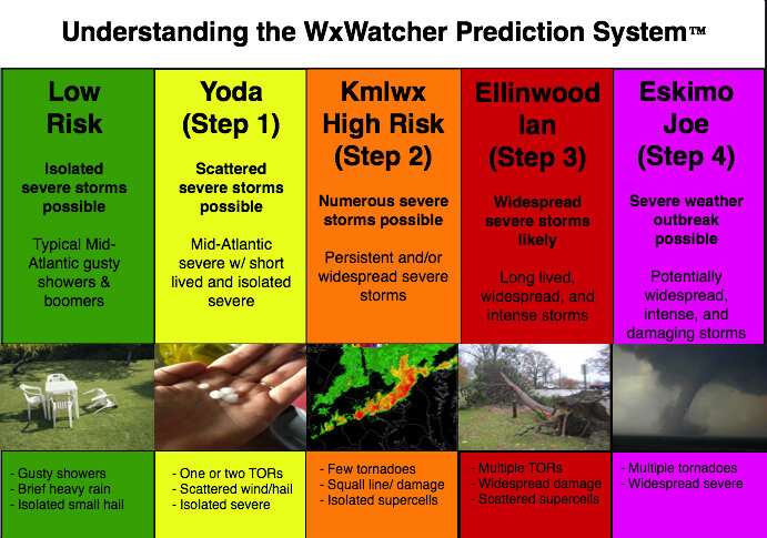
Mid February is usually when the early peeks at severe can sometimes start showing up. Judging by the models and the long range thread, looks like maybe a marginal threat for Thur night? General severe discussion, remembering past events, and all that usual stuff that goes in here each year can go in here again. Hopefully we get some good thunderstorms this spring and summer. Looking forward to plenty of copy and pasting from @yoda, downer posts from @Eskimo Joe, great analysis by @high risk, and plenty of sun obs that turn into nothing. Giddy up! And for humor sake - see below
-
This is around when I make the severe thread every year
-
Late January and February Medium/Long Range Discussion
Kmlwx replied to WinterWxLuvr's topic in Mid Atlantic
It's all the angles that are murdering us. F angles. The cold air angle, the sun angle - we can't catch a break.- 4,130 replies
-
- 1
-

-
- prime climo
- cold canada
- (and 1 more)
-
Late January and February Medium/Long Range Discussion
Kmlwx replied to WinterWxLuvr's topic in Mid Atlantic
The blazing sun angle will kill this threat before it even starts- 4,130 replies
-
- 1
-
-
- prime climo
- cold canada
- (and 1 more)
