Kmlwx
-
Posts
13,549 -
Joined
-
Last visited
Content Type
Profiles
Blogs
Forums
American Weather
Media Demo
Store
Gallery
Everything posted by Kmlwx
-

2022 Mid-Atlantic Severe Wx Thread (General Discussion Etc)
Kmlwx replied to Kmlwx's topic in Mid Atlantic
Some of the guidance has brought the activity earlier. A few CAMS even have the line entering around 17 or 18z. That's not going to work for severe weenies. 20z would be okay. -
2022 Mid-Atlantic Severe Wx Thread (General Discussion Etc)
Kmlwx replied to Kmlwx's topic in Mid Atlantic
It's not the sector that's centered over our area, but the SE sector from the 12z CIPS page at hr60 has June 1, 2012 as a pretty high analog. Doesn't show up at all on the sector centered over us. Taking a look at H5 it's not hugely different - but there are some key differences. It seems like the trough was more negatively tilting in 2012. We still have a couple days to adjust things - but I'm certainly not saying I expect that sort of result. But H5 is close enough to keep me interested. The 18z run of the NAM nest wasn't quite as impressive. -
2022 Mid-Atlantic Severe Wx Thread (General Discussion Etc)
Kmlwx replied to Kmlwx's topic in Mid Atlantic
Another thing I like about the models @high risk mentioned - is we seem to have a little wiggle room with timing. Even if it speeds up by 1-3 hours, we may be fine still as it currently has it around 0z Friday. The events we go full "meh" on tend to be ones where the stuff comes through at like 17-18z. Wiggle room is good! I think I like this threat more than I did the ENH day... -
2022 Mid-Atlantic Severe Wx Thread (General Discussion Etc)
Kmlwx replied to Kmlwx's topic in Mid Atlantic
Purely non-scientific/anecdotal - but on the NAM nest, the trajectory of those storms kind of matches some fun events if my memory hasn't completely failed yet. NAM nest has a pocket of good sig tor as well! -
2022 Mid-Atlantic Severe Wx Thread (General Discussion Etc)
Kmlwx replied to Kmlwx's topic in Mid Atlantic
YOU TAKE THAT BACK! lol -
2022 Mid-Atlantic Severe Wx Thread (General Discussion Etc)
Kmlwx replied to Kmlwx's topic in Mid Atlantic
This is the same timeframe, but for "at least 10 severe reports within 110km of a grid point"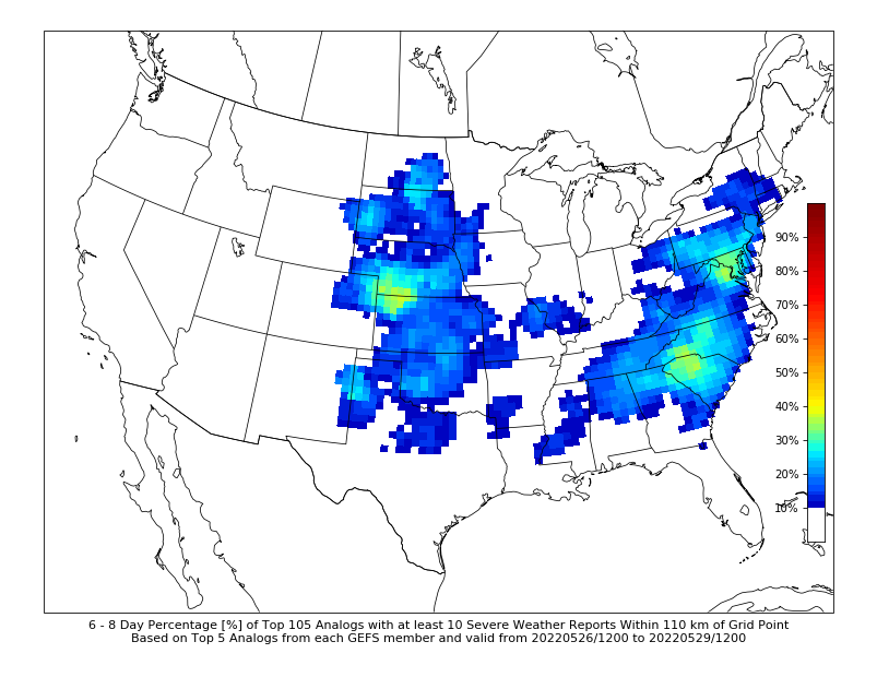
-
2022 Mid-Atlantic Severe Wx Thread (General Discussion Etc)
Kmlwx replied to Kmlwx's topic in Mid Atlantic
Extended CIPS analogs are honking for some severe potential at the 168hr frame. Strongest signal on that page I've seen so far this season/year for our region.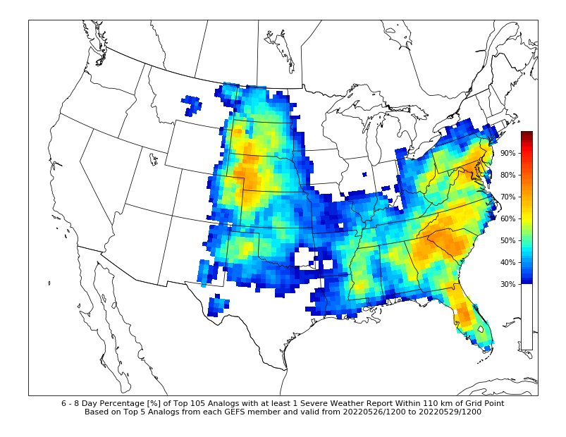
-
2022 Mid-Atlantic Severe Wx Thread (General Discussion Etc)
Kmlwx replied to Kmlwx's topic in Mid Atlantic
Yeah some of the guidance looks absolutely nothing like the actual radar at the moment. -
2022 Mid-Atlantic Severe Wx Thread (General Discussion Etc)
Kmlwx replied to Kmlwx's topic in Mid Atlantic
Maybe worth mentioning - or may be nothing - but that line entering western Maryland has not been well modeled on the short range guidance. Latest HRRR doesn't even have that line where it actually is. Probably will have a tendency to get tugged back into PA - but the area in the MCD could still get something out of this. -
2022 Mid-Atlantic Severe Wx Thread (General Discussion Etc)
Kmlwx replied to Kmlwx's topic in Mid Atlantic
Yep - definitely seems to be the case. Like @high risk said - only thing left for us is that it could be poorly modeled - but agreement has been pretty solid on the show being up in PA. No reason to expect otherwise right now. -
2022 Mid-Atlantic Severe Wx Thread (General Discussion Etc)
Kmlwx replied to Kmlwx's topic in Mid Atlantic
I'd feel better being up in @mappyland -
2022 Mid-Atlantic Severe Wx Thread (General Discussion Etc)
Kmlwx replied to Kmlwx's topic in Mid Atlantic
I saw a few model runs with good parameters but not much to show for it in terms of potential sensible weather. Maybe another day where we get one or two good cells but most of the area is meh. -
2022 Mid-Atlantic Severe Wx Thread (General Discussion Etc)
Kmlwx replied to Kmlwx's topic in Mid Atlantic
I think there's something to be said to timing of a threat too. For a nocturnal event, I can certainly see the merits of emphasizing a threat before average bedtimes since people may miss alerts ahead of time. But for a normal afternoon/evening severe events, there's plenty of time in the morning and even up to 12 or 1 for nowcasting and seeing how things like instability, CIN etc are playing out in real time before going big on an event. ENH for our area I truly believe is essentially the new moderate. It's still possible we'd get a moderate with hatching - but if you look at the breakdown of what is ENH vs MOD now - I think mod is going to be much harder for us to attain locally. -
2022 Mid-Atlantic Severe Wx Thread (General Discussion Etc)
Kmlwx replied to Kmlwx's topic in Mid Atlantic
If my memory is correct - a significant number of our *good* moderate days have come when SPC has added the moderate area at 13z or later. Without going to the SPC site, I believe June 4, 2008 was either bumped to a mod at 13z or 1630z. We call know June 29, 2012 was barely outlooked earlier that same day before going to a moderate risk as the line formed/approached. Am thinking there's other notable ones as well. I think the failure potential is just way too high to warrant moderate risks in this part of the country more than a few hours ahead. Too many variables. I don't envy SPC's job of course - and not digging on them - but elevating the risk area too far ahead of time can lead to public distrust over time...particularly in this day and age when SPC forecasts are all over social media and more widely seen by the public. -
2022 Mid-Atlantic Severe Wx Thread (General Discussion Etc)
Kmlwx replied to Kmlwx's topic in Mid Atlantic
83mph pixel showing up in Radarscope. TADW radar site took a beating it seems. -
2022 Mid-Atlantic Severe Wx Thread (General Discussion Etc)
Kmlwx replied to Kmlwx's topic in Mid Atlantic
There's gotta be some damage between Brandywine and Cedarville. TDCA is seeing almost 80mph winds. -
2022 Mid-Atlantic Severe Wx Thread (General Discussion Etc)
Kmlwx replied to Kmlwx's topic in Mid Atlantic
Outside of huge lines like derechos...this is how you can get some decent severe in these parts. Put up a lone cell that can pretty much have the environment to itself. That will definitely be the star of the show for today. -
2022 Mid-Atlantic Severe Wx Thread (General Discussion Etc)
Kmlwx replied to Kmlwx's topic in Mid Atlantic
GLM shows some lightning up to around Sterling that is not reflected on ENTLN. Maybe cloud-to-cloud. -
2022 Mid-Atlantic Severe Wx Thread (General Discussion Etc)
Kmlwx replied to Kmlwx's topic in Mid Atlantic
The NW side has expanded up to around Arcola, VA. If that heads more NE instead of E, DC proper could get in on some storminess. -
2022 Mid-Atlantic Severe Wx Thread (General Discussion Etc)
Kmlwx replied to Kmlwx's topic in Mid Atlantic
Lake Ridge is going to get walloped it looks like. Between Lorton and Woodbridge next. -
2022 Mid-Atlantic Severe Wx Thread (General Discussion Etc)
Kmlwx replied to Kmlwx's topic in Mid Atlantic
Now a warning for 70mph and half dollar sized hail. -
2022 Mid-Atlantic Severe Wx Thread (General Discussion Etc)
Kmlwx replied to Kmlwx's topic in Mid Atlantic
Pretty impressive cell! Pretty close (with some location differences) to what the HRRR was depicting earlier. -
2022 Mid-Atlantic Severe Wx Thread (General Discussion Etc)
Kmlwx replied to Kmlwx's topic in Mid Atlantic
Funny how earlier I thought best stuff would go north and east of me - now I'm worried about a miss south. Love weather. -
2022 Mid-Atlantic Severe Wx Thread (General Discussion Etc)
Kmlwx replied to Kmlwx's topic in Mid Atlantic
Yep - seeing growth now around Luray. -
2022 Mid-Atlantic Severe Wx Thread (General Discussion Etc)
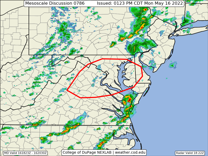
Kmlwx replied to Kmlwx's topic in Mid Atlantic
2nd Meso of the day (discussion above).