Kmlwx
-
Posts
13,549 -
Joined
-
Last visited
Content Type
Profiles
Blogs
Forums
American Weather
Media Demo
Store
Gallery
Everything posted by Kmlwx
-

2022 Mid-Atlantic Severe Wx Thread (General Discussion Etc)
Kmlwx replied to Kmlwx's topic in Mid Atlantic
-
2022 Mid-Atlantic Severe Wx Thread (General Discussion Etc)
Kmlwx replied to Kmlwx's topic in Mid Atlantic
And it was for 80% chance of watch. They are probably waiting longer to see convective trends/initiation. -
2022 Mid-Atlantic Severe Wx Thread (General Discussion Etc)
Kmlwx replied to Kmlwx's topic in Mid Atlantic
16z HRRR is advertising a decent complex of storms for extreme NoVA and into Central Maryland around 20z. -
2022 Mid-Atlantic Severe Wx Thread (General Discussion Etc)
Kmlwx replied to Kmlwx's topic in Mid Atlantic
I think there's two "issues" to watch. 1) As we've been hearing/saying all morning - the crapvection's impact on instability. I'm cautiously optimistic that the clearing is arriving soon enough that this may be mostly a negated issue. 2) Whether there's meaningful storms for us at all. It seems some of the guidance blows stuff up right along I-95 or east - so it's possible even if there is good convection that some of us get missed (isn't that always the case! lol) Guessing we'll still get a watch at some point, though. -
2022 Mid-Atlantic Severe Wx Thread (General Discussion Etc)
Kmlwx replied to Kmlwx's topic in Mid Atlantic
Well - here we go into the clearing. It's not quite to me in Colesville yet...but it's right on the doorstep. Should be solid for a decent amount of clearing. Temperatures elevated pretty quick in the clearing (seeing 76 degrees near Culpeper). Probably going to be a "garden variety+" severe day here. Perhaps a bit more widespread and intense than our true "meh" days but also not any sort of higher end/memorable event. -
2022 Mid-Atlantic Severe Wx Thread (General Discussion Etc)
Kmlwx replied to Kmlwx's topic in Mid Atlantic
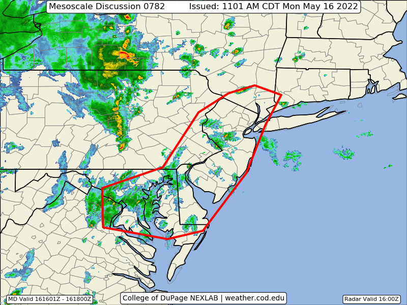
The 45% wind probs were removed at the 1630z outlook. The 5% tor probs were also removed. Adding those seemed iffy with the uncertainties. Let's see how the next hour or two plays out in terms of destabilization. The ENH as a whole was trimmed a bit in terms of areal coverage. -
2022 Mid-Atlantic Severe Wx Thread (General Discussion Etc)
Kmlwx replied to Kmlwx's topic in Mid Atlantic
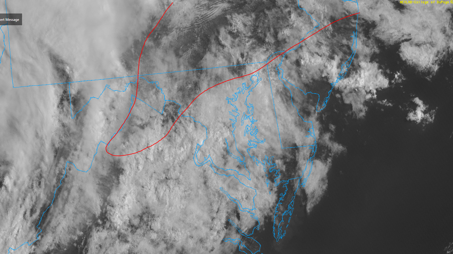
This is by no means locked in and not "obvious" - yes - the crapvection has lowered potential...but all it takes is a look at the visible satellite. There are big pockets of sunshine as close as Culpeper and breaks in the clouds already into the NoVA area as well. It's still possible the showers and isolated storms have stabilized us, but it's only 12:30 with clearing on our doorstep. Plenty of time for some sunshine to increase CAPE again. -
2022 Mid-Atlantic Severe Wx Thread (General Discussion Etc)
Kmlwx replied to Kmlwx's topic in Mid Atlantic
-
2022 Mid-Atlantic Severe Wx Thread (General Discussion Etc)
Kmlwx replied to Kmlwx's topic in Mid Atlantic
-
2022 Mid-Atlantic Severe Wx Thread (General Discussion Etc)
Kmlwx replied to Kmlwx's topic in Mid Atlantic
I'm hanging my hopes on the very nice area of clearing behind the crapvection - if that fills in for our area, I think we are out of the game for anything other than isolated instances of severe gusts.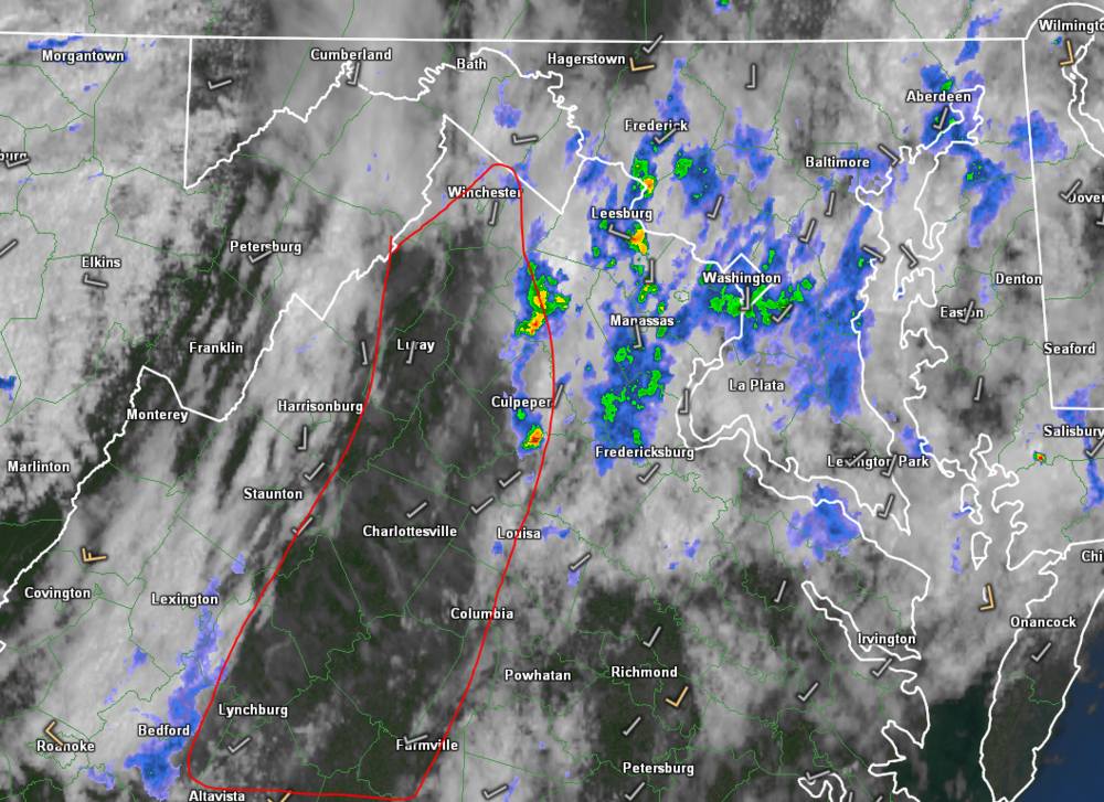
-
2022 Mid-Atlantic Severe Wx Thread (General Discussion Etc)
Kmlwx replied to Kmlwx's topic in Mid Atlantic
Decent breaks in the cloud cover are showing back near Lynchburg, Staunton and similar areas. If we can get the junky stuff out of here we could get a few hours of broken sunshine to get CAPE up again. -
2022 Mid-Atlantic Severe Wx Thread (General Discussion Etc)
Kmlwx replied to Kmlwx's topic in Mid Atlantic
All that cloudiness/shower activity just south of the area is heading north. Seems the area outlined in red is where the good sun is going to be. It's still early, though...and it's also possible the breaks in the clouds down near Farmville, VA can get up here after the junk moves through. I'm liking the area that SPC has in the 45% wind still. Matches relatively well with this more sunny area. I wouldn't be surprised to see it tugged just a bit more out of the DC/Baltimore area on the next update (maybe removing Baltimore.
-
2022 Mid-Atlantic Severe Wx Thread (General Discussion Etc)
Kmlwx replied to Kmlwx's topic in Mid Atlantic
One foot in and one foot out. Only way to be a weather enthusiast -
2022 Mid-Atlantic Severe Wx Thread (General Discussion Etc)
Kmlwx replied to Kmlwx's topic in Mid Atlantic
There is some junk stating to form in the cloudiness down in VA (Lynchburg to CHO area). That could really lower instability potential today. Still think odds are good at strong storms - but the usual routes to failure are present. Visible satellite does show a decent amount of clear areas from around Winchester up into the Frederick, MD area and then up into southern PA. -
2022 Mid-Atlantic Severe Wx Thread (General Discussion Etc)
Kmlwx replied to Kmlwx's topic in Mid Atlantic
HRRR the past few runs has been really stormy. Seems to be one of the most aggressive pieces of guidance at the moment. -
2022 Mid-Atlantic Severe Wx Thread (General Discussion Etc)
Kmlwx replied to Kmlwx's topic in Mid Atlantic
Have to keep the junky storms/showers out of the area until later. NAM nest shows some stuff out ahead that may dampen the threat. Even so, it still delivers a nice line around 20z. -
2022 Mid-Atlantic Severe Wx Thread (General Discussion Etc)
Kmlwx replied to Kmlwx's topic in Mid Atlantic
Definitely not sounding the "meh" yet, but tomorrow around 9am may be a different story. The curse of the day 2 ENH. Watch us wake up to a slight with 2/15/5 for tor, wind, hail. -
2022 Mid-Atlantic Severe Wx Thread (General Discussion Etc)
Kmlwx replied to Kmlwx's topic in Mid Atlantic
Point taken, but it's not the only product that doesn't look overly impressive. We'll see how things look tomorrow AM. -
2022 Mid-Atlantic Severe Wx Thread (General Discussion Etc)
Kmlwx replied to Kmlwx's topic in Mid Atlantic
Wish the models would be a little more enthused. HRDRPS looked decent, but a lot of the models are kind of anemic with activity tomorrow - at least compared to our higher end days. Not that I'm expected an outbreak...but for a day 2 enhanced - and one that @Eskimo Joe uttered the mod possible phrase...I'd expect more. I'm cautiously optimistic that I'm just reading too much into sim reflectivity and parameters - but the oranges and reds on supercell composite parameter just aren't there on the guidance that I'm looking at. No doubt that the area sees storm activity tomorrow afternoon...but I'm having some doubts as to whether it will be an ENH or MOD day. My mental storm prediction level is at a slight right now. -
2022 Mid-Atlantic Severe Wx Thread (General Discussion Etc)
Kmlwx replied to Kmlwx's topic in Mid Atlantic
Not that it means a ton 24 hours out, but some of the Sim reflectivity has left a little to be desired. Definitely a solid setup though. I'm a little concerned the best activity goes N of our area. @mappyville looks solid -
2022 Mid-Atlantic Severe Wx Thread (General Discussion Etc)
Kmlwx replied to Kmlwx's topic in Mid Atlantic
-
2022 Mid-Atlantic Severe Wx Thread (General Discussion Etc)
Kmlwx replied to Kmlwx's topic in Mid Atlantic
Large Day 3 Slight Risk from SPC for our region. Also runs south and way north into the northeast. -
2022 Mid-Atlantic Severe Wx Thread (General Discussion Etc)
Kmlwx replied to Kmlwx's topic in Mid Atlantic
Looking ahead - CIPS analogs still aren't really enthused with any severe potential for the next while. There does seem to be some uptick in the longer range analogs beyond 240hrs. That's way out there, though. We'll have to see if it's a snoozer of a spring severe season for the immediate DC area or if there is a rapid uptick as we get into our climo butter zone. We usually get a window from May into most of June where we can get some decent CAPE combined with still decent wind fields. Once we get to late June/July it tends to get more pulsey in nature as the shear is usually less impressive. -
2022 Mid-Atlantic Severe Wx Thread (General Discussion Etc)
Kmlwx replied to Kmlwx's topic in Mid Atlantic
PSA for GRAE users - version 3 is out and can be upgraded for a discount if you have v2. -
2022 Mid-Atlantic Severe Wx Thread (General Discussion Etc)
Kmlwx replied to Kmlwx's topic in Mid Atlantic
CIPS is relatively quiet for tomorrow - but does have May 13, 2000 and May 6, 1991 in the mix.