Kmlwx
-
Posts
13,549 -
Joined
-
Last visited
Content Type
Profiles
Blogs
Forums
American Weather
Media Demo
Store
Gallery
Everything posted by Kmlwx
-

2022 Mid-Atlantic Severe Wx Thread (General Discussion Etc)
Kmlwx replied to Kmlwx's topic in Mid Atlantic
Watch to the south of me boooooo -
2022 Mid-Atlantic Severe Wx Thread (General Discussion Etc)
Kmlwx replied to Kmlwx's topic in Mid Atlantic
Have gone form 65 or 66 back up to 69 now in Colesville. Getting little hints of sunshine now. Though it's not like high noon anymore. Not sure how much heating the sun will provide late in the day. -
2022 Mid-Atlantic Severe Wx Thread (General Discussion Etc)
Kmlwx replied to Kmlwx's topic in Mid Atlantic
I un-mehed as the line was rolling in earlier. Didn't hit severe here - and no damage IMBY - but it was a nice storm. -
2022 Mid-Atlantic Severe Wx Thread (General Discussion Etc)
Kmlwx replied to Kmlwx's topic in Mid Atlantic
Many of us aren't even in a slight risk anymore. -
2022 Mid-Atlantic Severe Wx Thread (General Discussion Etc)
Kmlwx replied to Kmlwx's topic in Mid Atlantic
Still stuck at 66 degrees here with full cloud cover. I may meh. -
2022 Mid-Atlantic Severe Wx Thread (General Discussion Etc)
Kmlwx replied to Kmlwx's topic in Mid Atlantic
The more recent HRRR runs have focused some better activity to the south in the next round but are a little less impressive than earlier runs in the immediate DC-Balt corridor. -
2022 Mid-Atlantic Severe Wx Thread (General Discussion Etc)
Kmlwx replied to Kmlwx's topic in Mid Atlantic
Showers running from SW of CHO down to Chatham, VA. Those could serve to increase cloud cover. We'll see how the pockets of clearing sustain or fill in in the NoVA/Central Maryland/DC areas in the next hour or two. The most recent mesoanalysis shows we are pretty worked over in terms of CAPE. -
2022 Mid-Atlantic Severe Wx Thread (General Discussion Etc)
Kmlwx replied to Kmlwx's topic in Mid Atlantic
Haven't really seen any sun here near Silver Spring. -
2022 Mid-Atlantic Severe Wx Thread (General Discussion Etc)
Kmlwx replied to Kmlwx's topic in Mid Atlantic
Other than glancing at the HRRR I haven't done a lot of looking at the next around yet. Finishing up some work stuff (was SUPPOSED to be a half day). Though from what I've seen on Twitter and on here - I'm intrigued. -
2022 Mid-Atlantic Severe Wx Thread (General Discussion Etc)
Kmlwx replied to Kmlwx's topic in Mid Atlantic
And warning fatigue is real - I think that's a solid call - especially in the DC area where (not ragging on LWX) but EVERYTHING seems to get a warning in severe season. -
2022 Mid-Atlantic Severe Wx Thread (General Discussion Etc)
Kmlwx replied to Kmlwx's topic in Mid Atlantic
Trend of having HRRR juice up that next line is a good one - I'll use the weenie-ism that maybe it's sampling the ground truth better with time -
2022 Mid-Atlantic Severe Wx Thread (General Discussion Etc)
Kmlwx replied to Kmlwx's topic in Mid Atlantic
Yeah - that's weird. I guess they are trying to get through the current batch - but that seems semi misleading for readers. They even trimmed probabilities as if this is it for the day. The new outlook has the "the front has cleared the area" kind of read to it. Maybe they are planning on just covering the remainder of the day with mesoscale discussions -
2022 Mid-Atlantic Severe Wx Thread (General Discussion Etc)
Kmlwx replied to Kmlwx's topic in Mid Atlantic
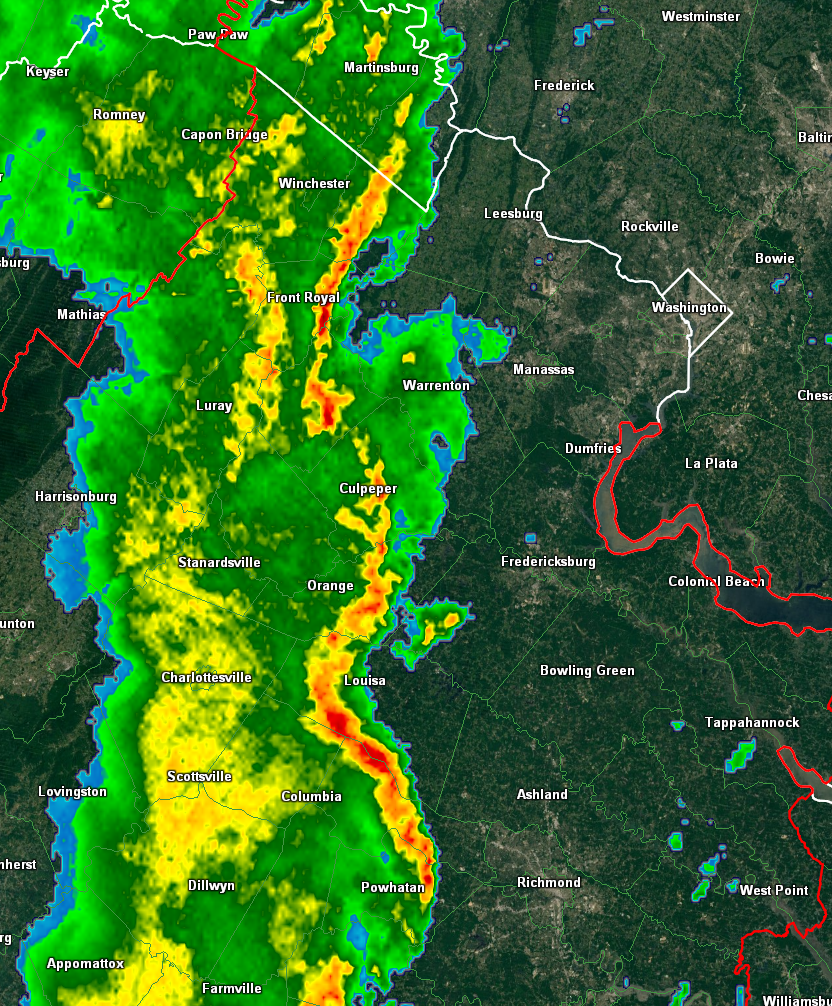
Pretty good storm - nice gusts of wind when it came through here in Colesville. Now we wait and see how the cloud cover does behind the line - looks like clouds will linger for a bit - but visible seems to suggest plenty of clearing ack towards Petersburg, Harrosonburg, even nosing into Luray area now. And even more west of there. -
2022 Mid-Atlantic Severe Wx Thread (General Discussion Etc)
Kmlwx replied to Kmlwx's topic in Mid Atlantic
Will be interesting to see trends with further HRRR runs as this line gets out of the way and the airmass behind it is ingested into the model. -
2022 Mid-Atlantic Severe Wx Thread (General Discussion Etc)
Kmlwx replied to Kmlwx's topic in Mid Atlantic
Looks LEWP-y for sure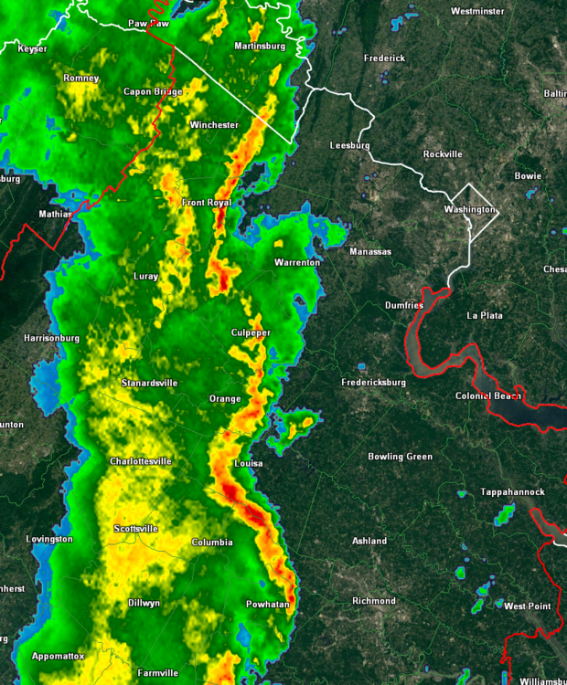
-
2022 Mid-Atlantic Severe Wx Thread (General Discussion Etc)
Kmlwx replied to Kmlwx's topic in Mid Atlantic
3hr SBCAPE change has been like +600 for most of us and even +1000 south of DC. Not bad. Even MLCAPE is +400 SE of DC. -
2022 Mid-Atlantic Severe Wx Thread (General Discussion Etc)
Kmlwx replied to Kmlwx's topic in Mid Atlantic
Seems like there has been an uptick in lightning on the part of the line down near/just south of Palmyra, VA. -
2022 Mid-Atlantic Severe Wx Thread (General Discussion Etc)
Kmlwx replied to Kmlwx's topic in Mid Atlantic
12 HRRR (still running now) really ramps us this early line and plows it through the area as scheduled. Should leave a decent amount of time for the airmass to recover/destabilize. Rare two round severe day seems more and more likely...though second batch I'd venture a guess won't be as severe. -
2022 Mid-Atlantic Severe Wx Thread (General Discussion Etc)
Kmlwx replied to Kmlwx's topic in Mid Atlantic
10z HRRR run suggests this is the main show between 16-18z and then we get some general thunderstorms/showers later on. ETA - the RAP indicates two distinct "tongues" of instability. One with the morning activity and then another surge of higher SB/MLCAPE values later on. -
2022 Mid-Atlantic Severe Wx Thread (General Discussion Etc)
Kmlwx replied to Kmlwx's topic in Mid Atlantic
Regardless of the end result - should be a lengthy day of tracking. Sometimes being able to track something throughout the day, rather than just waiting for initiation all day is fun. -
2022 Mid-Atlantic Severe Wx Thread (General Discussion Etc)
Kmlwx replied to Kmlwx's topic in Mid Atlantic
Honestly this is how we *could* get a full day under a tornado watch. Send this activity through by 16-18z and then we may be able to recover a bit of instability for a line around 0z. -
2022 Mid-Atlantic Severe Wx Thread (General Discussion Etc)
Kmlwx replied to Kmlwx's topic in Mid Atlantic
The hires FV3 runs a line through around 15z and then another more spotty one around 01z. I guess we could recover a bit between those two time periods...but 15z is prime time to ruin our instability IMO. Messy evolution. I'm about to meh. -
2022 Mid-Atlantic Severe Wx Thread (General Discussion Etc)
Kmlwx replied to Kmlwx's topic in Mid Atlantic
Yeah - lots are now hitting the 16-18z time period. That's too early for our hopes. We need 19z or later... -
2022 Mid-Atlantic Severe Wx Thread (General Discussion Etc)
Kmlwx replied to Kmlwx's topic in Mid Atlantic
When split between a meh and a yay, always go the EJ route of calling meh. I haven't had a chance to look at the 12z suite yet. -
2022 Mid-Atlantic Severe Wx Thread (General Discussion Etc)
Kmlwx replied to Kmlwx's topic in Mid Atlantic
04/2011 is shown in the analogs as well and That was our like 12 or 18 hours of tornado watches event.