

Kmlwx
-
Posts
13,549 -
Joined
-
Last visited
Content Type
Profiles
Blogs
Forums
American Weather
Media Demo
Store
Gallery
Everything posted by Kmlwx
-

2022 Mid-Atlantic Severe Wx Thread (General Discussion Etc)
Kmlwx replied to Kmlwx's topic in Mid Atlantic
Strong CIPS signal in the extended panels at 168hrs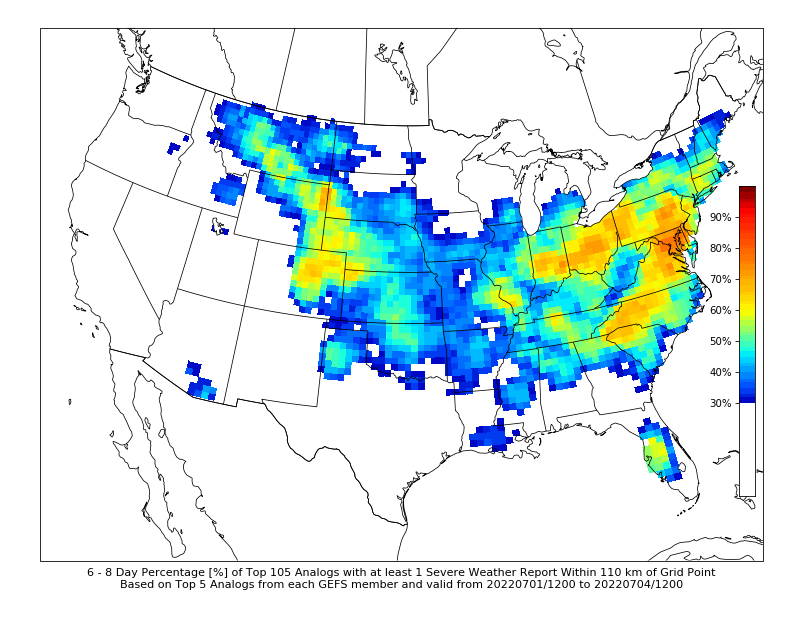
-
2022 Mid-Atlantic Severe Wx Thread (General Discussion Etc)
Kmlwx replied to Kmlwx's topic in Mid Atlantic
Rain intensity much lower now - band has weakened a good bit. Though it seems more activity will be off and on into the night. -
2022 Mid-Atlantic Severe Wx Thread (General Discussion Etc)
Kmlwx replied to Kmlwx's topic in Mid Atlantic
CLAM2 stream gauge is already seeing rises (as to be expected) with the heavy rain overhead. -
2022 Mid-Atlantic Severe Wx Thread (General Discussion Etc)
Kmlwx replied to Kmlwx's topic in Mid Atlantic
Looks like this N/S line is lined up roughly with the front. -
2022 Mid-Atlantic Severe Wx Thread (General Discussion Etc)
Kmlwx replied to Kmlwx's topic in Mid Atlantic
Flood warning for chunk of DC metro (including DC proper) -
2022 Mid-Atlantic Severe Wx Thread (General Discussion Etc)
Kmlwx replied to Kmlwx's topic in Mid Atlantic
Some really nice lightning and thunder here now. Loud cracks and rolling rumbles following. Let's see how long these training lines setup for and if they stay over the same general areas. Could be a long night for local first responders. -
2022 Mid-Atlantic Severe Wx Thread (General Discussion Etc)
Kmlwx replied to Kmlwx's topic in Mid Atlantic
Training potential now setting up for DC if this keeps up. Radar looks a lot more active locally than it has. Getting loud thunder here north of Silver Spring now. -
Could it be a volunteer fire dept? I know small towns use it to summon the volunteers back for calls. Or a weekly test of sorts?
-
2022 Mid-Atlantic Severe Wx Thread (General Discussion Etc)
Kmlwx replied to Kmlwx's topic in Mid Atlantic
That backdoor boundary seems to be killing us. -
2022 Mid-Atlantic Severe Wx Thread (General Discussion Etc)
Kmlwx replied to Kmlwx's topic in Mid Atlantic
Saw one on GR2AE as well. Wonder if some of that is due to the wind from the storms blowing up against the higher terrain and inducing some circulations. -
2022 Mid-Atlantic Severe Wx Thread (General Discussion Etc)
Kmlwx replied to Kmlwx's topic in Mid Atlantic
WPC frontal analysis shows the backdoor front running like this - Would certainly explain the death of activity in the DC/Baltimore corridor.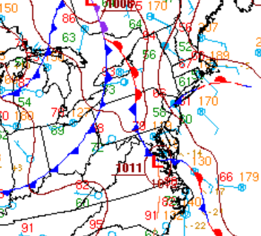
-
2022 Mid-Atlantic Severe Wx Thread (General Discussion Etc)
Kmlwx replied to Kmlwx's topic in Mid Atlantic
Yep - completely - but just in the sense that narrow corridors could see a decent amount of training. I could see a localized spot get sig flooding this evening even as most areas get garden variety heavy rain and some isolated cases of standing water -
2022 Mid-Atlantic Severe Wx Thread (General Discussion Etc)
Kmlwx replied to Kmlwx's topic in Mid Atlantic
It definitely seems like a setup where if you're in the right (or wrong) place, you could get trained over pretty good this afternoon and evening. I don't *think* it'll be anything like the training I saw in June 2006, but if the railroad tracks align it could be a hazardous afternoon for the usual standing water/flooding locations. Guessing at least 5 idiots will require water rescue from vehicles today. Will guess 3 pickup trucks and two minivans. -
2022 Mid-Atlantic Severe Wx Thread (General Discussion Etc)
Kmlwx replied to Kmlwx's topic in Mid Atlantic
Flood watch expanded -
2022 Mid-Atlantic Severe Wx Thread (General Discussion Etc)
Kmlwx replied to Kmlwx's topic in Mid Atlantic
Roughly along and west of I-95 there is some CAPE beginning to increase. Nothing ridiculous so far - but still an increase. LI values are actually not bad right in the metro area as well. -
2022 Mid-Atlantic Severe Wx Thread (General Discussion Etc)
Kmlwx replied to Kmlwx's topic in Mid Atlantic
The metro still gets some narrow "bands" or cells that go through but closer to 0-1z. The NAM nest still has some 2 inch amounts localized in that. It's definitely going to be a game of miles in some places today. -
And we aren't even to the climo hottest period of the year yet. We will torch in all likelihood - at least for a period and more likely for a long period sometime during July to early September.
-
2022 Mid-Atlantic Severe Wx Thread (General Discussion Etc)
Kmlwx replied to Kmlwx's topic in Mid Atlantic
My temperature is heading upward pretty fast now. Last 15-20 minutes I've gained like 3 degrees. I wouldn't be surprised if the flood watch gets extended maybe one more tier to the east - going to be an interesting day of radar-watching. -
2022 Mid-Atlantic Severe Wx Thread (General Discussion Etc)
Kmlwx replied to Kmlwx's topic in Mid Atlantic
Definitely one of the more strange sim reflectivity plots I've seen before. Still think a good chunk of the area will see precip - but I'm not sure there will be any sort of sustained severe threat for anyone in the immediate metro area. -
2022 Mid-Atlantic Severe Wx Thread (General Discussion Etc)
Kmlwx replied to Kmlwx's topic in Mid Atlantic
The NAM really focuses the threat west of the DC metro area. The Shenandoah region looks to have best chances on the latest 18z runs. -
2022 Mid-Atlantic Severe Wx Thread (General Discussion Etc)
Kmlwx replied to Kmlwx's topic in Mid Atlantic
Definitely ages away when it comes to severe weather prediction! But we will likely find a way to fail. Stood out to me as it's the boldest the colors have been over us in a while. -
2022 Mid-Atlantic Severe Wx Thread (General Discussion Etc)
Kmlwx replied to Kmlwx's topic in Mid Atlantic
Worth noting - solid CIPS severe signal at 168hrs on the 0z suite. -
2022 Mid-Atlantic Severe Wx Thread (General Discussion Etc)
Kmlwx replied to Kmlwx's topic in Mid Atlantic
Seems a good bet a good chunk of the area will see storms tomorrow. Intensity TBD. These past few days have been incredible from a comfort standpoint. -
2022 Mid-Atlantic Severe Wx Thread (General Discussion Etc)
Kmlwx replied to Kmlwx's topic in Mid Atlantic
Sim reflectivity has looked pretty consistently good on the CAMs. The one issue may be that some of us get missed to the west on a few models. We'll see how it looks tomorrow AM. I think it'll be a solid SLGT day. -
2022 Mid-Atlantic Severe Wx Thread (General Discussion Etc)
Kmlwx replied to Kmlwx's topic in Mid Atlantic
I'm watching tomorrow with interest so far.

