-
Posts
13,431 -
Joined
-
Last visited
Content Type
Profiles
Blogs
Forums
American Weather
Media Demo
Store
Gallery
Everything posted by Kmlwx
-

2022 Mid-Atlantic Severe Wx Thread (General Discussion Etc)
Kmlwx replied to Kmlwx's topic in Mid Atlantic
It's a real wait and see kind of thing. Really nice storms up there in IN/OH/MI -

2022 Mid-Atlantic Severe Wx Thread (General Discussion Etc)
Kmlwx replied to Kmlwx's topic in Mid Atlantic
Areas south are generally more favored to be warmer/more humid simply by being farther south. Humidity and heat are pretty crucial ingredients for severe weather and storms in general. Though every event is different - the climo for storms is higher south. -

2022 Mid-Atlantic Severe Wx Thread (General Discussion Etc)
Kmlwx replied to Kmlwx's topic in Mid Atlantic
Cappucci thinks it misses Maryland to the south and west it seems. -

2022 Mid-Atlantic Severe Wx Thread (General Discussion Etc)
Kmlwx replied to Kmlwx's topic in Mid Atlantic
Really no sig changes. -

2022 Mid-Atlantic Severe Wx Thread (General Discussion Etc)
Kmlwx replied to Kmlwx's topic in Mid Atlantic
Biggest thing I'm watching for now is timing. It's entirely possible we start to see the arrival time moved up as the storms unfold -

2022 Mid-Atlantic Severe Wx Thread (General Discussion Etc)
Kmlwx replied to Kmlwx's topic in Mid Atlantic
Yep. Not even close to having the same fuel available. -

2022 Mid-Atlantic Severe Wx Thread (General Discussion Etc)
Kmlwx replied to Kmlwx's topic in Mid Atlantic
WD index summer edition lol -

2022 Mid-Atlantic Severe Wx Thread (General Discussion Etc)
Kmlwx replied to Kmlwx's topic in Mid Atlantic
Probably safe to ignore weather until tonight. I personally still think something rather significant is possible - higher odds the farther north and west you go...but these things can surprise. -

2022 Mid-Atlantic Severe Wx Thread (General Discussion Etc)
Kmlwx replied to Kmlwx's topic in Mid Atlantic
SPC (in the day 4-8 outlook) mentions Thursday as a potential severe day as well - but low confidence at this range. Yoda may be tired of copy/paste soon. -

2022 Mid-Atlantic Severe Wx Thread (General Discussion Etc)
Kmlwx replied to Kmlwx's topic in Mid Atlantic
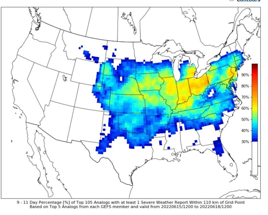
Also - looking at CIPS - it's pretty darn quiet and unenthused with anything in the short term (may not mean a ton). Around 100hrs and shortly after, there's a decent signal from the GL region/midwest and into our region. Bears watching since we are potentially entering a period with increased chances for a "ring of fire" pattern. -

2022 Mid-Atlantic Severe Wx Thread (General Discussion Etc)
Kmlwx replied to Kmlwx's topic in Mid Atlantic
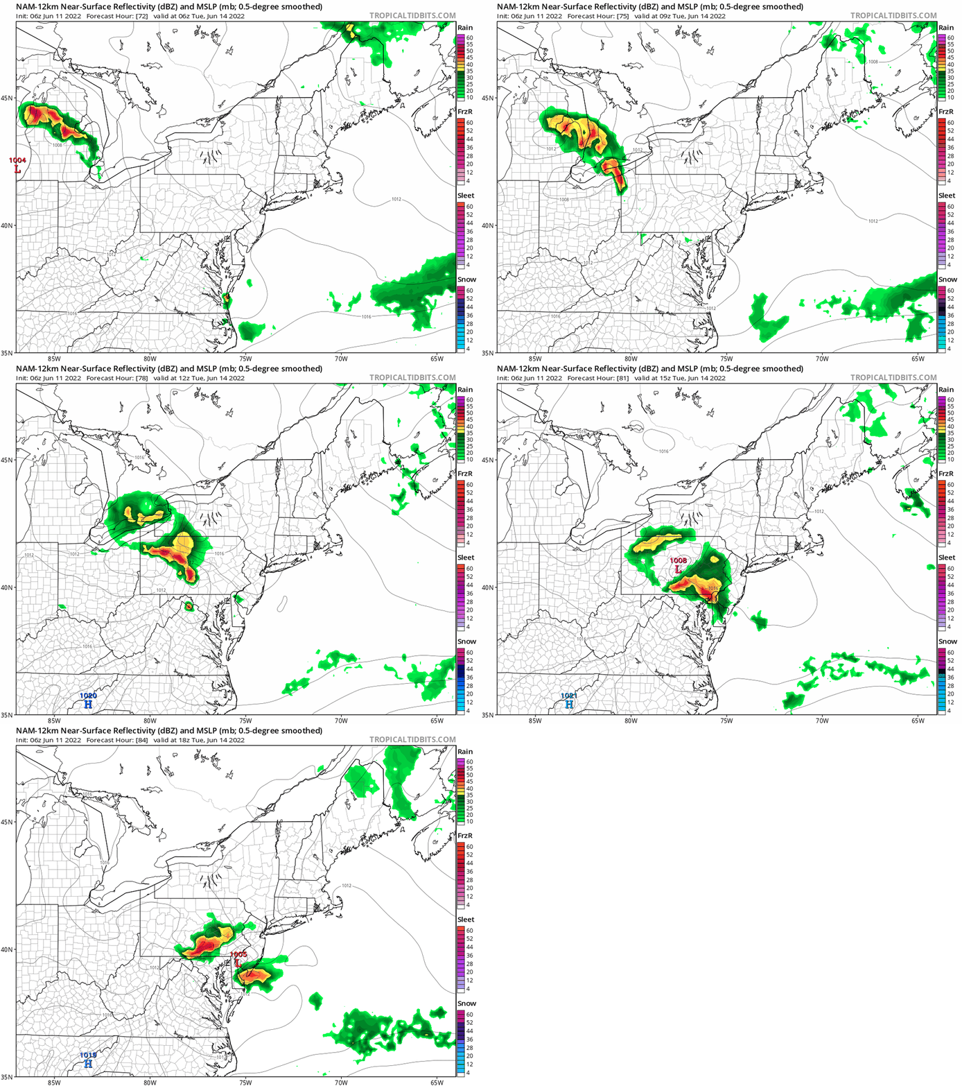
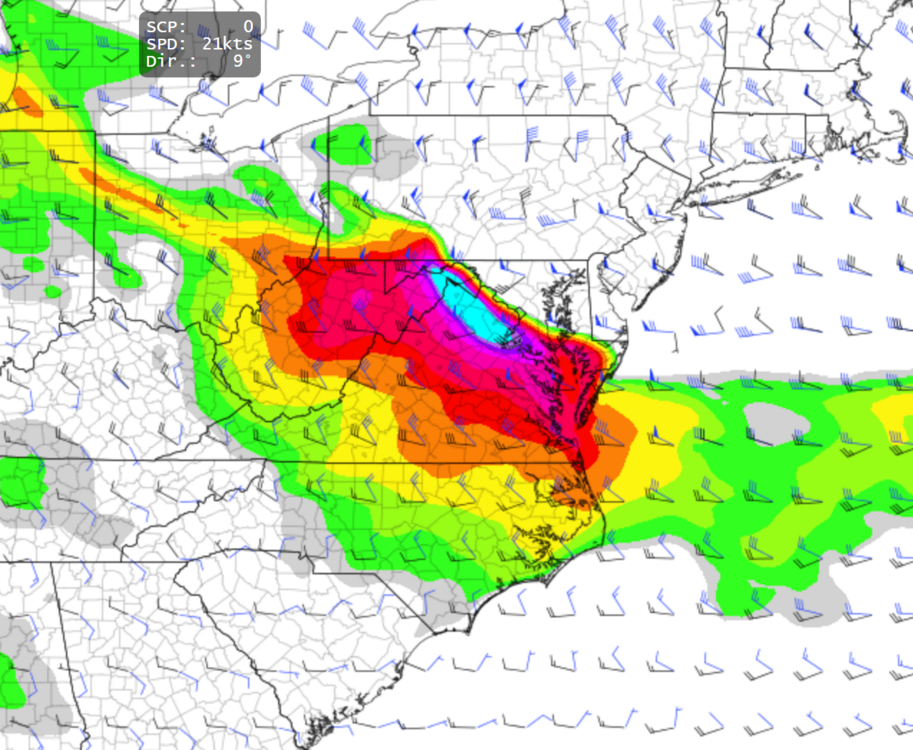
It's been a busy weekend...but I'm just now having a chance to come up for air and take a look at everything. We tend to get lines of storms ahead of schedule...not sure if this would apply to the D-word or large MCSs as well...but I'd assume so. Still, the current timing is well into the overnight period tomorrow night and even closer to 12z Tue AM on some of the models. That's not ideal as @high risk already said for true surface based activity. The 2012 derecho came through late into the evening - but it was also a ridiculously hot airmass area-wide and it was before midnight. 12z is like the worst time entirely for anything severe t'storm related (it's happened, yes...but it's rare). MCS activity (and particularly derechos) are insanely tough to model/predict...and when we are talking about sensible weather, a different of a hundred miles or two is going to mean a ton for your specific location. Few things that I'll be watching for - 1) how much instability is left if the line/complex comes through at that awful time in the diurnal cycle. 2) If the timing really is 12z Tue AM - I think even 6 hours earlier would increase the risk substantially - make it 8-12 hours earlier and even better for severe odds (I think 12 hours might be a tall task, though). 3) We'll need to see where the instability gradient sets up - it's a razor sharp margin on some of the models and if you're too far NE of that...game over. I think EVERYONE is in the game in this subforum for right now. That will obviously change as we get closer to (and into) the event. Doesn't mean anything - but that day 2 Outlook has "the look" of 2012...obviously not basing that on any other analog factor other than map drawings (which don't mean much). I think today will be a feast or famine - if a supercell or two form, somebody will get pummeled - but I'm punting. If something pops this evening, I'll track it of course. Buckle up...let's see what tomorrow holds as we get closer to the potential. -

2022 Mid-Atlantic Severe Wx Thread (General Discussion Etc)
Kmlwx replied to Kmlwx's topic in Mid Atlantic
All our eggs in tomorrow's basket I guess -

2022 Mid-Atlantic Severe Wx Thread (General Discussion Etc)
Kmlwx replied to Kmlwx's topic in Mid Atlantic
-

2022 Mid-Atlantic Severe Wx Thread (General Discussion Etc)
Kmlwx replied to Kmlwx's topic in Mid Atlantic
-

2022 Mid-Atlantic Severe Wx Thread (General Discussion Etc)
Kmlwx replied to Kmlwx's topic in Mid Atlantic
CIPS is pretty quiet. Does have some signature around hr168. -

2022 Mid-Atlantic Severe Wx Thread (General Discussion Etc)
Kmlwx replied to Kmlwx's topic in Mid Atlantic
The ensembles are still really liking a persistent NW flow pattern from 240 through the end of the runs. -

2022 Mid-Atlantic Severe Wx Thread (General Discussion Etc)
Kmlwx replied to Kmlwx's topic in Mid Atlantic
-

2022 Mid-Atlantic Severe Wx Thread (General Discussion Etc)
Kmlwx replied to Kmlwx's topic in Mid Atlantic
You can't. But the pattern fits. You also can't predict a KU 10 days out, but you can assess that the pattern could be favorable! -

2022 Mid-Atlantic Severe Wx Thread (General Discussion Etc)
Kmlwx replied to Kmlwx's topic in Mid Atlantic
As advertised...the GFS would seem to be a single day (maybe 2) potential and then things clear out. But you'd think if that ridge setup shop for any decent length of time, as the window gets closer more sustained chances could show up. Reminds me a bit of model watching for KU patterns in winter - if a window is real, threats show up later. -

2022 Mid-Atlantic Severe Wx Thread (General Discussion Etc)
Kmlwx replied to Kmlwx's topic in Mid Atlantic
12z GFS continues to look intriguing around the June 15th timeframe. Afternoon of June 15th on this run has 5000+ SBCAPE, nearly 4000 MLCAPE (over 4000 to the NW of the metro areas). Ripe supercell composite maps as well. Really impressive considering it's the GFS and not the NAM. Again, it's a eternity away at that timeframe...but it keeps the general potential on the table. Pulling a model forecast sounding from near the M/D line in northern Maryland yields this on the College of Dupage site - SFC CAPE = 5425 ML CAPE = 4554 SFC LI = -12 Sfc to 1km shear = 18kts Sfc to 3km shear = 32kts Sfc to 1km SRH = 116 Supercell Composite = 26.0 STP (cin) = 4.2 STP (fix) = 3.6 PWATS over 2 inches. -

2022 Mid-Atlantic Severe Wx Thread (General Discussion Etc)
Kmlwx replied to Kmlwx's topic in Mid Atlantic
We'll have to watch for the EML aspect of the upcoming period as well. The more recent GFS runs have sent most of the EML advecting north and east and not really into our region. However, the 18z GFS yesterday did move a pretty good EML for a big part of the east coast in the 270hr time frame. That stuff is far from being worked out. As stated above, the upper air pattern is the only thing I'm looking at with any seriousness this far out. Looking at where any EML is situated this far out is like tracking the rain/snow line in a fantasy 240+hr GFS snowstorm in winter. Guessing we have "higher than normal" odds at some decent severe...but whether the X-factors line up for us will determine (and luck, of course) whether it's something memorable or just a few days of hot weather afternoon storms with a pulsey nature. Reminder that our derecho climo around here is 1 derecho every 4 years (I think it's a bit higher to the north and west). -

2022 Mid-Atlantic Severe Wx Thread (General Discussion Etc)
Kmlwx replied to Kmlwx's topic in Mid Atlantic
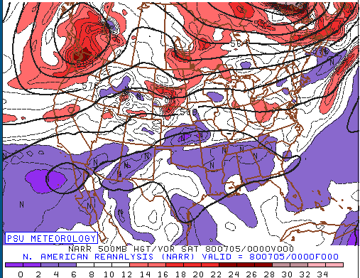
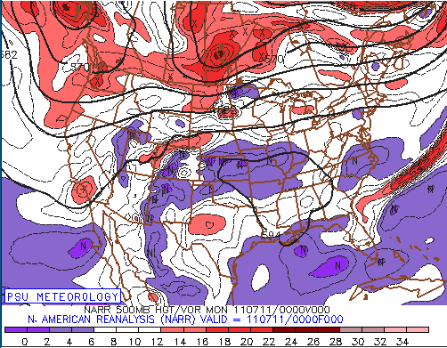
Here's some selected ones - along with the PSU Reanalysis maps for each. 1) July 4-5, 1980 - https://www.spc.noaa.gov/misc/AbtDerechos/casepages/jul4-51980page.htm 2) July 10-11, 2011 (I don't remember this one for some reason!) Not even going to include June 29, 2012 as we all know that one. -

2022 Mid-Atlantic Severe Wx Thread (General Discussion Etc)
Kmlwx replied to Kmlwx's topic in Mid Atlantic
@ravensrule would be in here in 2 seconds with a comment like that. I've just gone down the rabbit hole reading the "Noteworthy Derecho Events" page on the SPC site. -

2022 Mid-Atlantic Severe Wx Thread (General Discussion Etc)
Kmlwx replied to Kmlwx's topic in Mid Atlantic
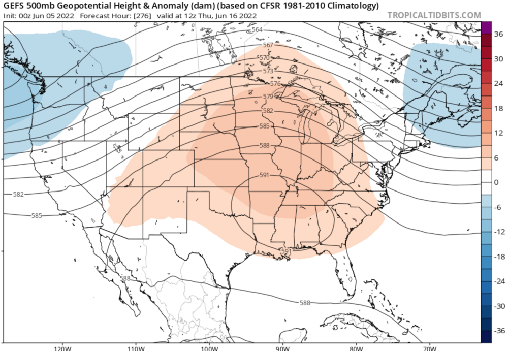
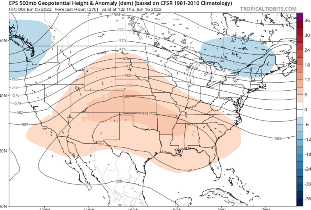
So my best friend CIPS isn't particularly exciting for anything both in the standard and extended range. HOWEVER, I'd be lying if I said i wasn't kind of excited for the day 10-15 period. GFS/Euro and their ensembles have some form of a big ridge to our west setting up. The exact position and "tilt" of this ride varies (of course...this far out it's to be expected). But almost all of them put us on the eastern side of a sprawling ridge...could be good for NW flow events if the stars align. Not saying the D-word this far out - but we might start to see some big time analogs on CIPS if the general looks keeps up. The 6z GFS has a high parameter day or two around the 270ish hour mark (usually GFS is pretty conservative on supercell composite paramter). This is from the 0z GEFS - I'd take this as a severe weenie And here's the Euro Ensembles So you can see the ridge axis and position varies - but on that EC ENS run it kind of wiggles around a bit before and after this frame. -

2022 Mid-Atlantic Severe Wx Thread (General Discussion Etc)
Kmlwx replied to Kmlwx's topic in Mid Atlantic
I finally have a weekend where I'm not running around a ton. Getting some outdoor activities in today, but hoping to look at the next period in more detail this evening


