

Kmlwx
-
Posts
13,203 -
Joined
-
Last visited
Content Type
Profiles
Blogs
Forums
American Weather
Media Demo
Store
Gallery
Posts posted by Kmlwx
-
-
I want a deep freeze to cut down on the annoying bugs in spring and summer. I bet we have a huge mosquito season if not.
-
 2
2
-
-
@csnavywx thanks for the great explanation for us weenies!
-
8 hours ago, Maestrobjwa said:
4 tornados...in one February day. Wow! (can't believe I'm posting in a severe thread in February, lol) Now...shall the old folklore about thunder and snow ring true this time? Stay tuned!

And in the morning no less. Very, very impressive event even by normal severe season standards.
-
1
-
-
20 minutes ago, NorthArlington101 said:
Did we just have our biggest event of the year? I totally missed this one.
This is only the beginning. Here's the seasonal projection from the weenie simulation -
Rest of February - Not much but maybe some gusty showers
March - Regular bouts of severe synoptic wind following behind monster lows with squalls and wedges rapidly raking the area.
April - Regular bouts of moist, warm air clashing with high shear events to warm us up for peak season.
May - Daily wedges
June - Daily wedges centered on the mall.
-
1
-
-
1 hour ago, WxWatcher007 said:
First biggie of the year.
Low CAPE, high shear events fail for us like 90 percent of the time.
-
1
-
-
Just now, yoda said:
Good amount of TW and STW for no watch this morning lol
Let's do this again with 80+ degree temps and 65+ dews.
-
We always seem to "luck" our way into at least one severe weather "event" every February. Then we usually go mostly dormant until April or May.
-
34 minutes ago, AdamHLG said:
Meanwhile, there are two tornado warning boxes in our CWA. Maybe the immediate focus should be an early start to severe season.
Come join the dark side over in my severe season thread!
-
1
-
-
Intense drive just now from the Colesville area to the Potomac/Rockville area. Wish I could have grabbed a picture of the clouds.
-
I looked at the CFS supercell composite maps on the COD page last night. This winter sucks.
-
 1
1
-
-
4 minutes ago, WarmNose said:
I don’t see a lot of upper air pattern maps posted in here. Probably because you guys are too busy chasing actual snowstorms. It seems us SE guys only chase patterns supporting snow and not the actual snow itself. Anyways, here’s a pattern map for you guys to mull over. Us southeastern guys like to call it “Spring”.
Upper air maps are posted here plenty.
-
1
-
-
2 minutes ago, Interstate said:
This is also 8 days away... Things will change.
No it's locked in. 8 days is the "rule" for whether something is happening or not.

-
1
-
 2
2
-
-
1 hour ago, Eskimo Joe said:
The "we are due" index is pretty high in several areas specifically:
1.) Derecho
2.) Tropical system/remnants
3.) EF-2 or greater tornado
4.) Large scale river flooding event
Sooner or later the pendelum is going to swing back on us.
EF-2 is exciting from a distance - but locally it's just too populated to hope for anything like that. Imagine if we pulled a prolonged ring of fire derecho pattern and then topped it off with a tropical system in the fall. Would easily make up for a dreadful winter (barring late turn around).
-
22 minutes ago, Eskimo Joe said:
From a climo perspective we are due for a derecho.
This is an excellent start to the thread. My only issue with derecho patterns is that they can be very hot ones...worth it for excitement I guess.
-
 1
1
-
-
It's only January...but with the winter season looking incredibly bleak...let's fire up the 2020 Mid-Atlantic Severe Disco Thread.
May our lack of winter weather this season forebode a spring and summer FULL of the folllowing
@yoda copying and pasting
@Eskimo Joe being bullish on events
@mappy getting to break out some GIS skills on something local
@Ian popping in to tell us the upcoming pattern looks ripe
@high risk with ample opportunity to educate us and keep our hopes high when it looks like we won't get sun before an event.
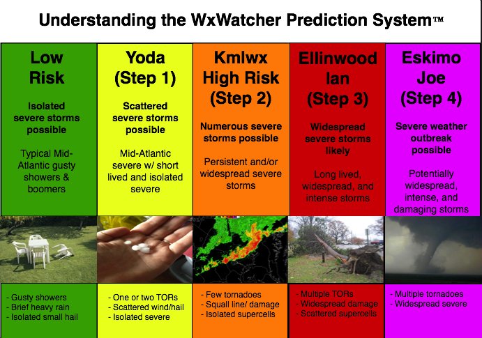
As a reminder - the Mid-Atlantic Severe Weather Reference Scale is displayed below - @WxWatcher007 to credit for this.
Let's shoot for a moderate risk in 2020.
-
5
-
 1
1
-
1
-
1
-
-
5 minutes ago, HighStakes said:
Then 2 drinks for every EPS probability map he posts that shows the red nowhere near us.
I'll be black out drunk by 10am...
-
2
-
-
2 hours ago, Weather Will said:
You may be right. But I got up at 345 to catch a train that is now an hour late because of a tree blown down on the track so I decided to look at the maps.
Can we start a drinking game? Each time Weather Will says "red flag" we take a drink
-
1
-
1
-
-
27 minutes ago, DCAlexandria said:
guys the front thump 3k is clearly a lot drier, a met just confirmed this JFC
You weren't addressing dry vs wet in your post. You said it showed all rain. (the ICON at least)
-
If the precip stays light - that *could* certainly lend some weight towards sig icing. Remember, with heavier rain it's tough to get icing due to the latent heat release. With a light (but perhaps semi steady) rain, fzra could more readily accumulate.
-
4
-
-
9 minutes ago, BTRWx's Thanks Giving said:
Trends in the MJO towards a null phase are concerning to me.
The phase it's in when it heads for the COD is important. A COD visit after going into phase 8/1 is different than it dying after being in the unfavorable ones.
-
4
-
-
Just now, Bob Chill said:
Warm front snow struggles to get 10:1 no matter what. High ratio stuff is with ULLs or CCBs. 8:1 is usually a good ratio to set expectations with warm fronts. The beginning can be high ratio but everything starts riming and clumping before pellets.
People also seem to have thought process that surface temps are the only thing that determines ratios. It is entirely possible (which I know you know) to have poor ratio snow and have the surface be 18 degrees.
-
1
-
-
5 minutes ago, yoda said:
Watch possible per latest MCD
Not for me. lol
-
1 minute ago, Prestige Worldwide said:
76 inside my house currently. Considering turning on the ac
Holy cow... Did the heat run or are you not very well insulated?
-
Assuming the most we'll get is a gusty shower. First meh of 2020 from me.
February Banter 2020
in Mid Atlantic
Posted
Why did NWS set the default radar view when you click the radar on the website to be composite? It's misleading IMO. It used to default to base reflectivity.