

Kmlwx
-
Posts
12,647 -
Joined
-
Last visited
Content Type
Profiles
Blogs
Forums
American Weather
Media Demo
Store
Gallery
Posts posted by Kmlwx
-
-
That storm is going bonkers right now...
-
50kft tops with it too! Impressive!
-
2 minutes ago, yoda said:
Golf ball sized hail and winds to 70mph on the supercell in NW VA just south of Stephens City
Question will become whether it will maintain strength as it crosses the boundary into the more stable airmass north of the front.
-
Just now, Eskimo Joe said:
How often do you see a box in a marginal risk?

This is extremely lame so far.
-
Tstm watch for areas west of the metro area.
-
The warned cell is exhibiting some supcellular qualities
-
Appears to be a boundary just south of the Potomac running across DC and then into Maryland. Visible nicely on satellite and even a bit on radar too.
-
15z HRRR keeps everything north and west of the cities. Doesn't get much at all into the metro corridor.
-
4 minutes ago, Eskimo Joe said:
Over the past 30 min or so we've gained some hazy sun in Gaithersburg and the winds aren't ripping out of the SE anymore. Maybe the front crawls north to a line along I-70 to Dover?
Definitely looks like a little "tongue" of clearing is working it's way into central MoCo.
-
Delmarva starting to erode the wedge but no such luck in the DC/Balt area.
-
30 minutes ago, Eskimo Joe said:
Gonna need to clear out ASAP if we want any chance at something today. Satellite reallly has the wedge holding firm.
Making a little progress - looks like DCA is out of the wedge and maybe even the southern parts of MoCo.
-
2 minutes ago, Eskimo Joe said:
Those are pretty silly parameters. Don't know why people use them.
I tend to just use them to get an idea of where the "best" activity might be - and also to look for consistency. Other than that I don't really think they have much use. I've seen days where they look crazy and we get nothing as well as days where just a little green shows up and we get multiple TORs
-
 1
1
-
-
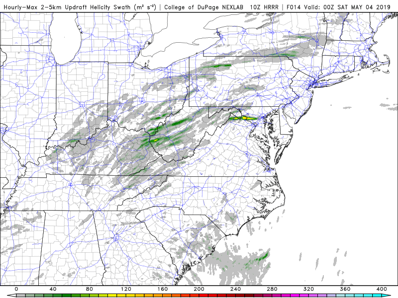
10z run of UD helicity swath map
-
The stupid UD helicity swath map
")
-
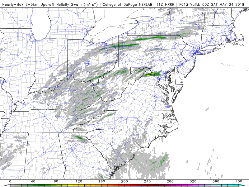
2 minutes ago, Eskimo Joe said:
Link?
Example from the 11z run - using the COD site - https://weather.cod.edu/forecast/
-
1
-
-
Consistency at least - of course it could be consistently wrong...
But 11z HRRR has almost the same thing. -
10z HRRR sends a legit looking supercell over Central Maryland this PM
-
2 hours ago, yoda said:
Sunday could be interesting if the NAM is right... Euro would make it meh
Are we looking at the same NAM? I don't see much of anything to get excited about on the NAM (18z OR 00z)
-
Tomorrow's threat appears to now be focused NW of the area by the longer range HRRR and the 3km NAM
-
Long range 12z HRRR (lol) has a streak of very nice UD helicity across the area tomorrow PM. Both today and tomorrow look good on simradar
-
2
-
-
Days and days and days of MRGL
-
34 minutes ago, yoda said:
I know I mentioned this in the April Banter thread -- but I will repost it here since mappy mentioned it in this thread:
To be honest- hearing my friends (non weather enthusiasts) and coworkers - most people still do not understand which is worse (watch vs warning). A lot of this is ignorance - watches don't trigger CMAS so it should be fairly obvious to the public that "TAKE SHELTER IMMEDIATELY" is more serious than "CONDITIONS ARE FAVORABLE"
-
1
-
-
The latest (11z) HRRR has essentially nothing
-
I'm right around 270 and Montrose - evil looking clouds but no tornado of course. Then heavy rain.
2019 Mid-Atlantic Severe Wx - General Discussion
in Mid Atlantic
Posted
Looking at LWX velocity scans I'm not sure i see much other than the abrupt windshift.